![]()
1 Introduction
Angela L. Coe
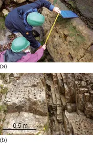
The main aim of field geology is to observe and collect data from rocks and/or unconsolidated deposits, which will further our understanding of the physical, chemical and biological processes that have occurred over geological time. Many of the basic observational principles used in field geology have not changed for hundreds of years, although the interpretation of the data, the scale of resolution and some of the equipment has advanced greatly. Fieldwork involves making careful observations and measurements in the field (Figure 1.1 a) and the collection and precise recording of the position of samples for laboratory analysis (Figure 1.1 b). The very act of collecting field data often raises questions about processes on Earth, which had perhaps not previously been envisaged. Furthermore, during fieldwork it is usual to initiate, or to build on, constructing and testing different hypotheses and interpretations based on the observations; this iterative process will help to determine the essential data and samples to collect.
This book is divided into 14 chapters. Chapter 2 covers the most commonly used field equipment and outlines field safety procedures. Chapter 3 explores the general objectives of fieldwork and how to make a start. Chapter 4 is devoted to the production of a field notebook (hard copy or electronic), as this is the key record of geological field data. The bulk of the book comprises five chapters covering the necessary skills for the collection of palaeontological (Chapter 5 ), sedimentological (Chapter 6 ), igneous (Chapter 7 ), structural (Chapter 8 ) and metamorphic data (Chapter 9 ). Chapter 10 uses the field techniques covered in the previous five chapters to introduce geological mapping, where it is usually necessary to deal with a range of rock types and different kinds of exposure*. The book concludes with short chapters on recording numerical and geophysical data (Chapter 11 ), photography (Chapter 12 ) and sampling (Chapter 13 ).
Field geology presents four main intellectual challenges. These are:
1. Deciding what data to collect in order to address the scientific question(s).
2. Finding the most suitable exposures from which to collect the data.
3. Making a good record of the data collected; preferably a record that can be understood by others and can be used years after the data were collected.
4. Understanding and interpreting the basic observations that you make.
This book deals with challenges 1, 2 and 3. Challenge 4, interpreting the observations, is to a large extent a matter of experience and having a good theoretical understanding of geology and geological processes. There are many general geological and Earth science textbooks on the market, a selection of which are included in the further reading lists at the end of each chapter. Deciding what data to collect relates directly to the objective of the fieldwork (Chapter 3 ). Some typical overall objectives are: constructing the geological history of a region (Chapter 10 ), collecting data on a period of climate change (Chapter 6 ), gathering evidence for a mass extinction event (Chapter 5 ), understanding a phase of igneous activity (Chapter 7 ) or mountain building (Chapters 8 and 9 ), together with finding and evaluating mineral or water resources and understanding natural hazards (e.g. landslides, earthquakes and fl oods; Chapters 6 and 8 ). Within each of these major objectives the fieldwork should be broken down into achievable daily tasks. Locating the most suitable exposures is crucial if the objective of the fieldwork is anything other than detailed mapping where ideally all exposures need to be examined. The different types of exposure are dealt with in Chapters 3 and 10, and more specific examples are given in Chapters 5 – 9. Throughout the book, but particularly in Chapter 4, we have provided ideas and examples for constructing effective field notebooks. We have also added practical tips in the margin, and fl owcharts for deductive thinking processes and tasks. In Chapters 5 – 10 we have used worked examples to demonstrate both the method of reasoning and the way in which particular problems have been tackled.
1.1 A selection of general books and reference material on geology
Allerby, M. 2008. A Dictionary of Earth Sciences, Oxford University Press, 672 pp.
Bishop, A., Woolley, A. and Hamilton, W. 1999. Minerals, Rocks and Fossils, Cambridge University Press, 336 pp. [Small book with colour photos and brief, reliable descriptions of minerals, rocks and fossils.]
Cockell, C., Corfield, R., Edwards, N. E. and Harris, N. B. W. 2008. An Introduction to the Earth - Life System, Cambridge University Press and The Open University, 328 pp. [Full colour book covering Earth system science at the Earth ’ s surface with particular reference to life systems.]
Grotzinger, J., Jordan, T. H., Press, F. and Siever, R. 2006 .Understanding Earth ( 5th edition ) W. H. Freeman & Co., 670 pp. [An outstanding, clearly written, widely used introduction to Earth sciences with many colour illustrations providing a global perspective.]
Keary, P. 2005. Penguin Dictionary of Geology, Penguin, 336 pp.
Murck, B. W. 2001. Geology: A Self - teaching Guide, John Wiley & Sons, 336 pp.
Rogers, N. W., Blake, S., Burton, K., Widdowson, M., Parkinson, I. and Harris N. B. W. 2008. An Introduction to Our Dynamic Planet, Cambridge University Press and The Open University, 398 pp. [Full colour book covering the solid Earth aspects of Earth system science, including planetary formation, the Earth ’ s structure, plate tectonics and volcanology.]
Rothery, D. A. 2010. Teach Yourself Geology ( 4th edition ), Hodder and Stoughton, 288 pp. [Covers all of the basics and is useful as either a primer or a refresher.]
Stanley, S. 2005. Earth System History, W. H. Freeman & Co., 567 pp. [Accessible look at the Earth as a system. Extensively illustrated in full colour.]
1.2 Books on geological field techniques
Compton, R. A. 1985. Geology in the Field, John Wiley & Sons, 398 pp. [Comprehensive but dense black and white book on basic geology and field techniques. Replacement of Compton ’ s Manual of Field Geology (1962).]
Freeman, T. 1999. Procedures in Field Geology, Blackwell Science, 93 pp. [Pocket sized, black and white book covering mainly mapping techniques, with particular emphasis on compassclinometer and trigonometric solutions for recording the geometry of geological features.]
Maley, T. S. 2005. Field Geology Illustrated, Mineral Land
Publications, 704 pp. [Book illustrating geological features and terms through hundreds of clear black and white photographs and line drawings.]
See also: Barnes and Lisle 2003 (Section 10.7 ); Fry 1991 (Section 9.5 ); McClay 1991 (Section 8.4 ); Stow 2005, Tucker 2003 (Section 6.6 ); and Thorpe and Brown 1991 (Section 7.5 ).
![]()
2
Field equipment and safety
Angela L. Coe
This chapter covers general geological field equipment and its use. It also provides an overview of the health and safety requirements in the field. More specialist field equipment and safety considerations are covered within Chapters 5 – 10 where appropriate. Sampling is covered as a separate topic in Chapter 13 and photographic equipment is briefly reviewed in Chapter 12. All the health and safety notes provided in this book are generic. Other sources and regulations will need to be consulted and followed depending on the field area, the country, the nature of the fieldwork and the regulations of your employer or educational institution.
2.1 Introduction
Before going out into the field it is necessary to: (1) assemble all of the field equipment that you might need; (2) assess any safety issues; and (3) if necessary obtain permission to visit the area. Both the safety and permission aspects may require documentation to be completed. Exactly what equipment you will need depends on the type of fieldwork you will be undertaking. The items required for most fieldwork tasks are listed in Table 2.1, and the equipment usually needed for sampling in Table 2.2 on p. 6. Optional equipment and that needed for more specialist tasks is listed in Table 2.3 on p. 6.
Quantification of geological observations
In almost all cases geological observations should be quantified because of the need to construct accurate and precise records. This is achieved through the use of measuring tapes, a compass - clinometer, rock comparison charts and more sophisticated geophysical equipment. This chapter provides information on how to master the basic geological measurements. More advanced techniques and those applicable to particular rock types are covered in the later chapters and more specialist books.
Table 2.1 Equipment required for most geological fieldwork. Clothing and safety equipment is discussed in Section 2.11 .
| Essential field equipment |
| Field notebook |
| Pencils, eraser, pencil sharpener |
| A few coloured pencils |
| Tape measure, surveyor ’ s tape or folding ruler |
| Hand lens |
| Compass - clinometer |
| Comparison and identification charts appropriate to the task |
| Relevant topographical maps |
| First aid kit and any personal medical supplies that might be required |
| Backpack/rucksack |
| Food and water sufficient for the fieldwork period |
| Emergency food supplies |
| Suitable clothing and footwear |
| Spare clothing and/or sunblock as appropriate |
| Mobile phone, radio or satellite phone |
| Safety equipment as appropriate |
How accurate the measurement needs to be, or whether an estimate is sufficient, depends on the objective of the exercise and the quality of the exposure. For example, if all you need is a general description of a sandstone body it may be sufficient to describe it as a sandstone with beds of variable thickness between about 10 cm and 2 m. However, if you need to sample the sandstone or determine how the thickness of the individual units varies laterally then it will be necessary to measure the thickness of each of the units. Equally in most cases there is a need to record the azimuth (direction relative to north) and the magnitude of the vertical angle or dip to the nearest couple of degrees rather than just the general direction. This is because of the need to convey important information on the direction of different processes (e.g. folding or palaeocurrents) and, importantly, enable an accurate record of the geometry of rock units to be calculated and recorded.
2.2 The hand lens and binoculars
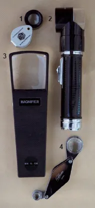
The hand lens is an essential piece of equipment for the detailed observation of all rock types and fossil material. Most have a lens with 10 × magnification and some contain both a 10 × and a 15 × or 20 × lens (Figure 2.1 ). If your eyesight is poor, a better quality lens will often help, especially a larger lens. It is also possible to obtain lenses with built - in lights, which can enhance the image considerably, e.g. Figure 2.1 ; lenses 2 and 3.
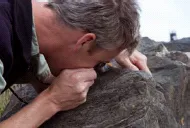
To use the hand lens, ensure that you are standing firmly or sitting down. Examine the specimen carefully first with the naked eye to find an area where it is fresh rather than weathered or covered in moss or lichens or algae, and also so that you can see where there are areas of interest such as well defined grains or crystals. If necessary, to ensure that when you look through the lens you have the correct area, place your finger tip or thumb tip as a marker adjacent to the area of interest identified with your naked eye. Place the lens about 0.5 cm away from your eye. Then, gradually move either the rock if it is a hand specimen, or yourself and the lens if it is an exposure, until the majority of the field of view comes into focus (usually about 1 – 4 cm away; Figure 2.2 ). Not all of the rock ’ s surface will be in focus at the same time because of its unevenness. You will need to rotate the hand specimen or move your position to look at different areas. In the case of some metamorphic rocks and carbonate sedimentary deposits it is also useful to examine a weathered surface because the minerals or grains sometimes weather out and are often easier to see.
Binoculars can be very useful during fieldwork. They can be used to assess access, for instance in mountain regions. However, their most common use is to obtain a better view of the details within parts of an exposure that are impossible to reach safely, or are simply better viewed from a distance (e.g. geometry of features such as faults and river channel infills). They are particularly useful for examining the detail of contacts between different units in vertical sea cliffs and quarry faces. A wide range of good quality lightweight binoculars is available on the market.
2.3 The compass-clinometer
The compass-clinometer is used to measure: (1) the orientation of geological planes and lineations with respect to north; and (2) the angle of dip of geological features with respect to the horizontal. This allows an accurate record of the geometry of the features to be constructed. The compass - clinometer can also be used in conjunction with a topographic map to accurately determine location.
There are two main types of compass - clinometer design on the market (Figure 2.3, pp...