![]()
North Yorkshire: The Dales
The Yorkshire Dales National Park extends over an area of 1,770 square kilometres (680 square miles) of limestone hills, covering most of north-west Yorkshire. There are no big towns, and most settlements are well separated and of great local character, without mills and industrial clutter. The land is mostly used for sheep farming, interspersed with cattle and arable in the more fertile areas.
The Dales contain much of the finest limestone scenery in the UK, with glacier-cut valleys, limestone pavements and crags, and stone-built settlements that merge with the landscape. Each valley or ‘dale’ has its own distinctive character, shaped over thousands of years by the people who have lived and worked there: building the dry-stone walls, stone barns and flower-rich hay meadows. There are also spectacular waterfalls, sparkling rivers and becks (streams), and ancient broadleaved woodlands to be explored. The area does possess some industrial heritage which can be found in the scattered remains of former mine workings and other rural industries high up on the moors.
Limestone is fine-grained grey rock comprised mostly of the chalky shells of marine organisms that sunk to the bottom of a shallow sea around 300 million years ago. The rock is mostly a form of calcium carbonate that dissolves slowly in water, creating cracks that, over millions of years, grow into caverns. Water flows down through these cracks, taking the soil with it, eventually creating areas of exposed rock which can become very extensive. Examples of this can be seen at Malham Cove, in the Ribble Valley, and around Ingleton.
It is fantastic country for ramblers, cyclists and climbers who can roam its lanes and byways, but there is also a world to explore underground. The Dales are riddled with caves and potholes which are a magnet for speleologists who can access the vast network through many entrances scattered over the hills. Squeezing through ‘The Cheese Press’ in the damp darkness underground may not seem like fun to most, but the adventure of exploring this hidden world attracts hundreds of devotees and guided pot-holing for beginners is available in towns like Settle and Ingleton.
The Yorkshire Dales are intriguing and accessible, and a landscape where every bend and summit reveals another ravishing view, beckoning the visitor on to discover more.
The upper reaches of Arkengarthdale at Langthwaite.
Overlooking Malham Tarn. The wood and marsh are owned by the National Trust wildlife study centre whose building is just out of the picture.
Malham, and the Mystery of Malham Cove
Malham is a small village surrounded by spectacular Dales countryside at the source of the River Aire. Although it is high and quite remote, people have lived here for a long time and traces of Iron Age boundaries and Bronze Age hunting are still to be found. The economy has always been rural, although a couple of small cotton mills provided employment during the 19th century, but they were too remote, so industry never got a foothold. Malham is exceptionally picturesque, with the young river running through the middle of the village, crossed by stone bridges and the green dales rising to the heights on either side. Sitting on its banks after a day’s walk, enjoying a drink while the birds sing is hard to beat.
Malham’s Waterways
As has been said, rainwater slowly dissolves limestone, forming cracks and caverns, and doing very surprising things to waterways. A stream, which must be one of the shortest in England, flows out of Malham Tarn (previous page) and runs for less than a kilometre before entirely disappearing down a crack in the rocky surface. 1.6 kms to the south lies Malham Cove, which was formed by a large ice-age river that fell 80 m (260 ft), eroding the limestone to form this spectacular cliff. The river flow decreased over the centuries as its water found other routes, until the Cove became a dry cliff. (Although, exceptionally, a waterfall reappeared for the first time in centuries in December 2015 following the extremely high rainfall that flooded much of north-west England.)
Malham Beck emerges from a cave at the bottom of the Cove, but this stream is NOT directly connected to the one leaving the Tarn above. So it seems that streams cross each other at different levels inside the cave system lying behind the cliff. Cavers continue to explore the system in an effort to solve the mystery of where the water goes on its journey.
Malham Beck is joined by Gordale Beck at Malham to form the River Aire, which flows south through Skipton to Leeds, before emptying into the Ouse at Goole, at the opposite end of the county. A steep climb up Gordale Beck from Malham is rewarded with waterfalls and the spectacular limestone formations of Gordale Scar.
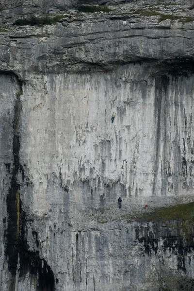
The vertical scale of the Malham Cove cliff can be judged from the image on the right where two climbers look like ants on the overhanging cliff face. Surprisingly, there are over 250 recognised climbing routes up the Cove, and climbers regularly reach the top without falling off!
Limestone-walled fields rising from Malham village.
Malham Cove with climbers.
The Ribble Valley
The River Ribble starts at Ribble Head, which is the spectacular location of the Ribblehead Railway Viaduct (see page 41), although its actual source is a little further up the dale at Gayle Moor. The Viaduct was built in the 1870s as an alternative north–south railway route by over a thousand men who lived along with their families in temporary villages nearby. It is 440 yards (400 m) long and 104 feet (32 m) above the valley floor, carrying the Settle to Carlisle railway line over the boggy solitude of Batty Moss.
The viaduct lies in the midst of The Three Peaks, which are Whernside (page 51) to the north, Ingleborough (page 47) to the south-west and Pen-y-Ghent (page 40) to the southeast. Climbing all three of these in a single day is one of the most popular challenges in England, involving a 25 mile walk and 5,000 feet of ascent. This is quite an achievement in a single day, although as Alfred Wainright pointed out, the countryside is so beautiful and full of interest that cramming too much into one day seems to be missing the point somewhat.
The River Ribble flows south between the slopes of Ingleborough and Pen-y-Ghent, through a limestone landscape where strangely-shaped pale grey rocks stick up in the middle of the grassy fields, and huge cliffs line the valley in which are found the entrances to potholes and caverns. The village of Horton-in-Ribbleside (page 40) lies halfway down the dale, and is a favourite starting point for the many hikers and cavers. The river tumbles down a small waterfall below the village where, in the autumn, salmon can be seen leaping towards their spawning grounds in the high fells. The image opposite shows a group of photographers by the river at Horton, waiting to catch the migrating fish on their cameras as they leap through the air.
This is a watershed, so the River Ribble flows down between the attractive town of Settle and Giggleswick village and then heads west to Preston and the Atlantic coast; while just a few miles away, the River Aire flows east.
Settle Market Place and the Olde Naked Man Cafe, which is reputed to be the oldest cafe in England. The market is open on Tuesdays and, like the town shops, is known for its local produce.
Photographers waiting for salmon to leap on the River Ribble at Horton.
St Oswald’s Church at Horton-in-Ri...