eBook - ePub
Forgotten World
The Stone-Walled Settlements of the Mpumalanga Escarpment
- English
- ePUB (mobile friendly)
- Available on iOS & Android
eBook - ePub
Forgotten World
The Stone-Walled Settlements of the Mpumalanga Escarpment
About this book
If you drive through Mpumalanga with an eye on the landscape flashing by, you may see, near the sides of the road and further away on the hills above and in the valleys below, fragments of building in stone as well as sections of stone-walling breaking the grass cover. Endless stone circles, set in bewildering mazes and linked by long stone passages, cover the landscape stretching from Ohrigstad to Carolina, connecting over 10 000 square kilometres of the escarpment into a complex web of stone-walled homesteads, terraced fields and linking roads. Oral traditions recorded in the early twentieth century named the area Bokoni – the country of the Koni people. Few South Africans or visitors to the country know much about these settlements, and why today they are deserted and largely ignored. A long tradition of archaeological work which might provide some of the answers remains cloistered in universities and the knowledge vacuum has been filled by a variety of exotic explanations – invoking ancient settlers from India or even visitors from outer space – that share a common assumption that Africans were too primitive to have created such elaborate stone structures. Forgotten World defies the usual stereotypes about backward African farming methods and shows that these settlements were at their peak between 1500 and 1820, that they housed a substantial population, organised vast amounts of labour for infrastructural development, and displayed extraordinary levels of agricultural innovation and productivity. The Koni were part of a trading system linked to the coast of Mozambique and the wider world of Indian Ocean trade beyond. Forgotten World tells the story of Bokoni through rigorous historical and archaeological research, and lavishly illustrates it with stunning photographic images.
Trusted by 375,005 students
Access to over 1.5 million titles for a fair monthly price.
Study more efficiently using our study tools.
Information
CHAPTER ONE
NEW IDEAS ABOUT OLD DATA
How we are learning about Bokoni

Photograph: Graeme Williams
Who lived there?
The term ‘Bokoni’ means the area of Koni settlement. We use it – though not exclusively – in preference to the term ‘Bakoni’, the Koni people, a formulation which tends to invoke images of static, bounded tribal cultures which certainly do not capture the social realities which prevailed in Bokoni.
The term ‘ Sekoni’ is used to describe the language which dominated in the area. For at least 200 years this language has been closely related and connected to North Sotho ( Sepedi). But language was not a fixed peak in this cultural landscape. Sekoni emerged out of a long historical interaction between individuals and groups. Indeed, it is likely that in the early phases of the development of Bokoni Nguni dialects predominated, giving way to Sotho forms after the arrival of new settlers, along with trade, intermarriage and Pedi political control.
Combining archaeological and historical sources has formed the core of new understandings of the stonewalled sites in Mpumalanga.1 Reconceptualising through collaboration has allowed us to explore beyond the boundaries of our disciplines, to use old data sources in new and exciting ways, and to link stone-walled sites and engravings with oral and written histories. But this collaboration has only been possible because of the particular insights and methodologies provided by the specific disciplines which have been involved. In this chapter we outline key forms of archaeological and historical evidence.
Buildings in stone
For archaeologists and historians who study these ancient settlements, the fact that stone was used for building is a great help. We can find out what kinds of structures the people built and the ways in which the buildings were arranged in relation to each other to produce the distinctive settlement pattern which characterises Bokoni society and distinguishes it from other black farming communities in southern Africa. We can also easily map the locations of these settlements because, as they are in predominantly grassy environments, the stone walls show up clearly on aerial photographs and even on satellite images.
Among the maze of stonewalling there are three main elements visible today: the homesteads, the terraced fields and the road networks. In precolonial southern Africa straight lines and right angles, drawing-board rigidity, were not part of people’s concepts of how to arrange the spaces they lived in. Instead, circular shapes dominated the arrangement of domestic space – the individual house, the cattle pen and the homestead as a whole – while the layout of paths, roads and fields followed the contours and other natural features of the landscape. At Bokoni, a homestead typically has a circular cattle pen in the centre with a variety of usually smaller structures around it, and sometimes there is a roughly circular outer wall enclosing the whole homestead.

Dense Bokoni settlement near Machadodorp with numerous circular homesteads, interconnecting roads and terracing.
(Photograph: Graeme Williams)
(Photograph: Graeme Williams)
Sometimes several homesteads cluster closely together whereas others are spaced quite widely apart. Some homesteads were built on open ground, but many are surrounded by terraces. An area of terracing may extend for several kilometres along the gentler slopes of a valley, covering as much as fifty square kilometres or more, and the homesteads, whether clustered or scattered, are often joined to one another by a system of roads defined by a stone wall on each side. The roads were evidently built to control the movement of livestock from the central cattle pen of the homestead through the terracing to the open veld beyond. In this way livestock could be moved out to the pastures each morning for grazing and watering, returning in the evening to the safety of the homestead, without the risk of the animals grazing on the crops growing on the terraces as they pass by.
Engravings
Apart from the stone walls themselves, there is another source of information that helps us to understand the pattern of these buildings, as some of the inhabitants made engraved pictures on rock surfaces. A few of these engraved images show animals and many are merely meandering lines which we can’t interpret, but the majority show homesteads and settlements as if seen from above.
Research has shown that many of the black farming communities which moved into the grassland areas of South Africa and adopted stone as a building material also made rock engravings. The adoption of stone for building seems to have been a stimulus for the making of images on exposed rock surfaces, for plans of settlements are the most common type of image produced. The emphasis seems always to be on the homestead, especially the cattle pen or pens at its centre, and the paths taken by the cattle. By contrast, those features of the settlement specifically associated with women – the granaries and individual houses – are seldom shown, and there are no cultivated fields. Since the management of cattle in these societies was exclusively reserved for males this suggests (and is the dominant explanation) that engraving was mainly done by boys and young men, whose responsibility it would have been to look after the livestock as they moved around the grazing areas.2 With plenty of time on their hands, it is not surprising that these youths sometimes turned their attention to depicting, on the rocks, the settlement patterns that gave order to their daily lives – as in children’s art today, where houses and familiar landscapes are some of the most frequently depicted images. And, again, as are today’s images, the rock engravings of settlements are not accurate maps of any actual buildings on the ground. Among the black farming communities the shape of the settlement closely reflects the structure of the family in terms of each person’s age, gender and status, as well as the importance of the family cattle herd, not only as food but also for its symbolic and religious values. So in the process of pecking out the shape of a homestead on a rock the artists are exploring and recording their understanding of the cultural space they live in.

Photograph: Riaan de Villiers
This helps us to understand one of the more complicated engraved rocks. The boulder is five metres across and covered by circular homestead images connected to each other by lines representing roads. One can see that the homesteads are mostly depicted as several concentric circles, like the pattern of the ruined homesteads themselves. Homesteads are placed on the flatter top part of the boulder or on small flat areas formed by the natural weathering of the rock. The interlinking lines depicting paths and roads avoid the steepest angles of the boulder, and some of them continue right down to where the boulder meets the ground. The positions of the homesteads and the routes chosen for the roads show that the artists were aware of how their settlements would have been laid out in reality. The artists were imagining the boulder as a model of a hill and placing the engraved images in places on it appropriate to where homesteads and interconnecting routes would have been placed on a real hill. They were not trying to draw a map of an existing settlement but, rather, using their imagination to show how a settlement might have been set out if this particular boulder was really a hillside.
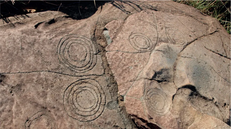
Large boulder with engravings depicting circular homesteads linked by interconnecting roads.
(Photograph: Riaan de Villiers, Drawing: Tim Maggs)
(Photograph: Riaan de Villiers, Drawing: Tim Maggs)


MATERIAL CULTURE
Archaeological reconstruction of any ancient way of life will always include an examination of the settlements where the people lived and the artefacts and other material (even the rubbish) they left behind. From the kinds of artefacts that have been recovered we can draw some conclusions about the daily lives of the communities which built these elaborate walling systems.
Ceramics
Pottery is one of the most useful types of artefact for archaeological research because the clay lends itself to the expression of very distinct styles peculiar to particular societies at particular periods. Even though the pots have usually broken up into small pieces, it is still possible to reconstruct their shapes and styles of decoration from the remaining sherds. Pottery was closely connected with many aspects of the work carried out by women, some of whom would also have made the pots.
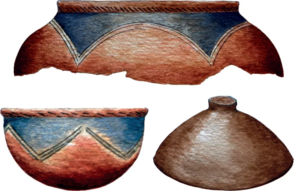
Well decorated pots of the Marateng style and a lid typical of the Bokoni sites redrawn from pottery excavated by Collett near Badfontein. (Drawing: Tim Maggs)
The style of pottery that has been found on the ground as well as excavated from homesteads on terraced settlements around Lydenburg, Badfontein and Machadodorp has been given the name Marateng by DP Collett, after a mountain close to his excavations.3 Most of the pots are coarsely finished and undecorated, or at best have a row of diagonal impressions just below the rim. These would have been the everyday vessels for fetching water, cooking and storage, but typically there are also a few pots which are beautifully decorated in contrasting colours. They also have the row of diagonal dashes on the neck but in addition there are broad arcades or triangles on the shoulder, marked out with grooved lines. The shapes are burnished to a dark, shining finish with graphite which contrasts with the bright red ochre burnish on the rest of the pot. These highly decorated pots clearly had a different use from the plain ones. Another commonly excavated item of household crockery is the pot lid, which is usually coarsely made and undecorated.
Some pottery styles may be closely identified with a particular ethnic group, but not so the Marateng style which was almost the same as that found among the Pedi people just to the north.4 Traditional Pedi ceramics, in fact, have all the features of pottery excavated at the terraced settlements and described above. A particularly interesting set of such pottery, now in the South African Museum, Cape Town, was collected in 1946 from the community living at Boomplaats near Lydenburg. Here again we find examples where the necks are decorated with a row of dashes and there are arcades and triangles on the shoulders, outlined by grooves and filled with graphite burnish which provides a vivid contrast to the red ochre of the neck and body.
The Boomplaats community included families of both Koni and Pedi descent who had a long association with this neighbourhood, and including some whose forbears lived in terraced settlements.
But the Marateng style is still more widespread than suggested by these examples. Similar pots were made in Sekhukhuneland, the heartland of the Pedi kingdom. Books on traditional pottery by JF Schofield and A Lawton tell us that during the twentieth century many of the potters in this area were Swazi women who were making pottery in the Pedi (or Marateng) style for sale to Pedi people (this is surprising since the style of traditional Swazi pottery is quite different and much simpler). Archaeological excavations by Alex Schoeman have also revealed Marateng-style pottery at eighteenth and nineteenth century settlements of the Ndzundza Ndebele in the Steelpoort valley, west of the terraced settlements.
Marateng-style pottery therefore seems to have been used by a wide variety of different communities living on and around the Mpumalanga escar...
Table of contents
- Cover
- Title Page
- Copyright
- Contents
- Preface
- Introduction
- Chapter One: New Ideas About Old Data: How We Are Learning About Bokoni
- Chapter Two: The Arrival Of Farming, The Growth Of Trade And Links To The Indian Ocean World
- Chapter Three: Making Of A Walled World: Context And Emergence Of Bokoni
- Chapter Four: A New Way To Manage Fields, Cattle And People
- Chapter Five: Neighbours And Raiders
- Chapter Six: The Old In The New: Legacies In The Nineteenth And Twentieth Centuries
- Conclusion
- A select bibliography
- Index
Frequently asked questions
Yes, you can cancel anytime from the Subscription tab in your account settings on the Perlego website. Your subscription will stay active until the end of your current billing period. Learn how to cancel your subscription
No, books cannot be downloaded as external files, such as PDFs, for use outside of Perlego. However, you can download books within the Perlego app for offline reading on mobile or tablet. Learn how to download books offline
Perlego offers two plans: Essential and Complete
- Essential is ideal for learners and professionals who enjoy exploring a wide range of subjects. Access the Essential Library with 800,000+ trusted titles and best-sellers across business, personal growth, and the humanities. Includes unlimited reading time and Standard Read Aloud voice.
- Complete: Perfect for advanced learners and researchers needing full, unrestricted access. Unlock 1.5M+ books across hundreds of subjects, including academic and specialized titles. The Complete Plan also includes advanced features like Premium Read Aloud and Research Assistant.
We are an online textbook subscription service, where you can get access to an entire online library for less than the price of a single book per month. With over 1.5 million books across 990+ topics, we’ve got you covered! Learn about our mission
Look out for the read-aloud symbol on your next book to see if you can listen to it. The read-aloud tool reads text aloud for you, highlighting the text as it is being read. You can pause it, speed it up and slow it down. Learn more about Read Aloud
Yes! You can use the Perlego app on both iOS and Android devices to read anytime, anywhere — even offline. Perfect for commutes or when you’re on the go.
Please note we cannot support devices running on iOS 13 and Android 7 or earlier. Learn more about using the app
Please note we cannot support devices running on iOS 13 and Android 7 or earlier. Learn more about using the app
Yes, you can access Forgotten World by Tim Maggs,Alex Schoeman,Peter Delius,Tim Maggs,Alex Schoeman,Peter Delius Delius in PDF and/or ePUB format, as well as other popular books in History & African History. We have over 1.5 million books available in our catalogue for you to explore.