![]()
Section 1. Background
Introduction
The site
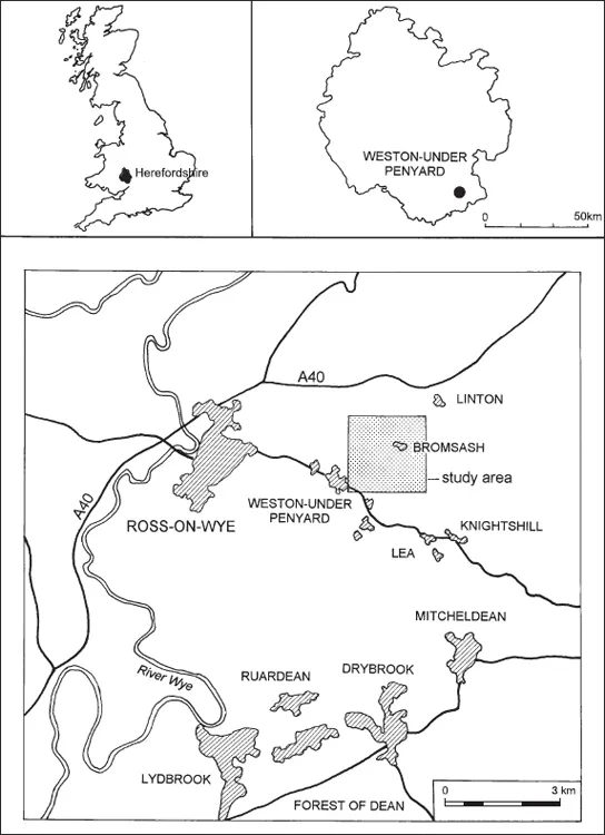
The Roman settlement at Weston-under-Penyard is located at NGR SO 645 240, a few miles to the east of Ross-on-Wye in south Herefordshire (Fig. 1.1). The site is generally recognised as the Roman ‘small town’ of Ariconium (Rivet 1970). Much of the former settlement is under regular arable cultivation although several minor roads cross it and its eastern side is affected by the small hamlet of Bromsash.
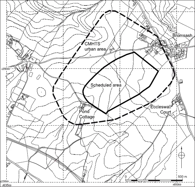
Ariconium is one of the most important Roman sites in Herefordshire and the region as a whole. Part of the settlement area is a scheduled ancient monument (County Monument number, Here. and Worc. 154; Fig. 1.2) and it has long been known as a major iron production centre. As such it has been identified as one of a group of specialised ‘small towns’ with an industrial function (Burnham and Wacher 1990). Of these Ariconium is probably one of the least well understood and, over the years, the general paucity of information has hindered synthetic studies (VCH I 1908; Crickmore 1984; Burnham and Wacher 1990; Dalwood 1994). The most recent of these was able to define an urban area (CMHTS; Dalwood 1994; Fig. 1.2). However, no details of the chronology, development or layout of the settlement could be identified.
The combination of poor understanding of the settlement allied to a threat from soil erosion mean that effective management and protection of the archaeological deposits has been identified as problematic (Jackson and Hancocks 1998).
The Arionium Project was consequently undertaken between 1998–2003 in response to this situation with the aim of assessing the current state of knowledge and establishing a framework for future research and management at the site.
Topography and geology
The focus of occupation lies between 85m and 125m OD on a fairly flat hilltop from which the ground falls away gently to the north and south (Fig. 1.2). A scarp forms the eastern side of the hill and slight promontories extend to the north and west. Drainage is predominantly westwards along three small streams. The focus of occupation lies on the western side of the hill with activity quite clearly extending down the hillsides towards the streams.
The solid geology consists of Breconian and Dittonian Old Red Sandstone (British Geological Survey 1990, 1:250,000 sheet 51ºN–04ºW) giving rise to well drained easily cultivated soils typical of the Eardiston 1 association (Soil Survey of England and Wales, 1:250000, Sheet 3, Midland and Western England). These soils are subject to erosion especially on cultivated slopes, where sheet and gully erosion often occur following heavy storms (Ragg et al. 1984). At Ariconium erosion of this type has been noted during fieldwork by both the Service and the Agricultural and Development Advisory Service (ADAS).
The project
Project design
The project was designed in recognition of the poor level of understanding of this nationally important site and, particularly, to address specific problems identified by the CMHTS (Dalwood 1994). These were considered to relate to both management and research frameworks. In addition, hillslope erosion has been identified as a potentially significant threat to archaeological deposits and one of the principal aims of the project was to assess the impact and extent of this problem.
Data has been drawn from a study area based upon a 2km2 centred on the scheduled area, thus covering the whole of the main cropmark complex and finds concentration as well as incorporating several areas of activity in the immediate hinterland (Figs 1.1 and 1.2). A wide range of sources have been consulted and reassessed, including aerial photographs, excavation and fieldwalking data, and museum collections. A significant amount of material has been available for study for the first time. In addition, data gathered from the area of the settlement by ADAS has been analysed and, in conjunction with archaeological evidence, has contributed to the development of an understanding of the nature, scale and causes of erosion at Ariconium. This has implications for the future management of this particular site as well as other sites in similar locations.
The project is seen as being particularly opportune, combining the study of both old and recently published evidence with analysis and incorporation of a large amount of data which had previously been unpublished. Assessment, analysis and discussion has lead to a synthetic overview of the archaeology of an important, but poorly understood, Roman industrial ‘small town’ and to an improved understanding of the impact of erosion on the site.
This has led to the creation of a better and more focussed management and research framework for this nationally important site.
Figure 1.1. Location of Ariconium project study area. Reproduced by permission of Ordnance Survey on behalf of HMSO. © Crown Copyright 2011. All rights reserved. Ordnance Survey Licence number 100051813
Aims and objectives
The original aims and objectives (CAS 1995) remained little changed throughout the project, falling under two headings management and academic. These largely arose from the Central Marches Historic Towns Survey report (Dalwood 1995) and from the preparation of the Project Design (CAS 1995, sections 4 and 5.1).
Figure 1.2. Study area showing CMHTS urban extents and scheduled area. Reproduced by permission of Ordnance Survey on behalf of HMSO. © Crown Copyright 2011. All rights reserved. Ordnance Survey Licence number 100051813
Academic objectives
These are grouped under five headings: character, development, morphology, economic activity and hinterland settlement. These were more specifically broken down as follows.
CHARACTER (SECTION 5)
1. What was the nature of pre-Roman occupation at the site?
2. What is character of the earliest Roman occupation?
3. Does the evidence support the suggestion of religious and military activity?
4. How does Ariconium compare with other Roman-British industrial ‘small towns’ in the area such as Droitwich and Worcester, and with the town of Kenchester? How can it contribute to the understanding of ‘small towns’?
5. What was the nature of post-Roman activity at the site?
MORPHOLOGY (SECTION 5)
1. Can an Iron Age occupation area be defined?
2. Can the area of the earliest Roman occupation be defined?
3. How was the settlement laid out in the Roman period and can roads and domestic and industrial zones be identified? Do these change through time? What implications do these have for the understanding of the settlement as a ‘small town’?
4. Can areas of military and religious activity be defined?
DEVELOPMENT (SECTION 5)
1. Can Iron Age origins be demonstrated and how do these relate to the subsequent Roman activity? What are the implications for the understanding of the Iron Age to Roman transition period?
2. What is the date of the earliest Roman occupation at the site?
3. Can the chronological development of the Roman settlement be established?
4. Can a date for the decline and desertion of the Roman occupation be established?
ECONOMIC ACTIVITY (SECTION 5)
1. What was the nature of the Roman ironworking industry? What were its sources of supply, its technology and products? What can this information contribute to the understanding of this highly important regional and national industry?
2. What does the other evidence for the economic function of the settlement tell us about it in terms of other industrial activities, agricultural base, and the evidence of its trading network?
HINTERLAND SETTLEMENT (SECTION 5)
1. What was the nature of the other Roman settlements (farmsteads etc) known in the immediate hinterland (within the study area; Fig. 1.2) of the site? Can these be related to Ariconium and if so what was this relationship?
2. What is the potential for reconstructing the surrounding landscape before and during settlement of the site? What impact did settlement, industry and agriculture have on, for example, woodland cover and soil erosion?
MANAGEMENT OBJECTIVES (SECTIONS 3 AND 6)
1. What impact has post-Roman activity had on Roman deposits?
2. What is the condition, survival and vulnerability of deposits and artefacts across the site?
3. How severe is hillslope erosion across the site and what are the factors which are causing it?
4. Can changes in the composition of the surface assemblage and visible cropmarks through time be detected and if so what contribution can they make to understanding the impact of erosion?
5. What are the effects of hillslope erosion and deposition on archaeological deposits and on approaches to identifying and interpreting them?
6. What is the role agricultural management plays in determining whether hillslope erosion occurs? What options are there for future management which would minimise the effects of such erosion?
7. What is the identifiable extent and potential impact of metal detecting in and around the scheduled area?
Focussing on these aspects of academic research and management has allowed the project to achieve the following:
• Contribute to the research framework and understanding of the site, with particular reference to its origins and chronological development.
• Revise definition of urban area and definition of components.
• Define immediate hinterland settlements and road network within study area.
• Contribute to the development of an effective site management framework.
• Contribute to the identification and understanding of the effects of hillslope erosion on archaeological sites.
• Enhance SMR and CMHTS.
• Disseminate the results through publication.
Related work
The project has been related to a number of other independently resourced areas of research, contributing to them and also drawing on them. Two particular areas of interest have been identified:
1. The information relating to erosion and its impact on a scheduled ancient monument is seen as having particular relevance to the long-term aims of the English Heritage funded Monuments At Risk Survey (MARS). Ariconium falls within one of the MARS field transects and it is envisaged that the project will provide information on causes and scale of the deterioration of preservation of deposits at this particular site over a period of time. This can potentially contribute to one of the key long-term focuses of investigation by the MARS project (Darvill and Fulton 1998).
2. Ongoing research as part of a PhD thesis and research programme being undertaken at Cardiff University into sourcing iron ores and products has fed into the project. Samples taken from Roman contexts and one potential Iron Age context at Ariconium on the Welsh Water pipeline were submitted for analysis as part of the University’s research programme (Thomas and Young 1999a; 1999b). In conjunction with data from work undertaken by English Heritage (AML) on slag from Ariconium resulting from the same project this has supported discussion of the character and scope of the ironworking industry at Ariconium and in the Forest of Dean. In particular this data has supported the production of tentative estimates of the potential output of the iron industry at...