![]()
CHAPTER 1
Phytodiversity of Burkina Faso
NACOULMA BLANDINE MARIE IVETTE, OUEDRAOGO ISSAKA, OUEDRAOGO OUMAROU, DIMOBE KANGBENI, and THIOMBIANO ADJIMA
University Ouaga1 Pr Joseph Ki-Zerbo, 03 BP 7021 Ouagadougou 03, Burkina Faso, E-mail:
[email protected]1.1 About Burkina Faso
Burkina Faso is a landlocked country located in the heart of West Africa with an area of around 274,200 km2. Its neighboring countries are Niger in the East, Benin, Togo, Ghana, and Ivory Coast (Côte d’Ivoire) in the South and Mali in the North (Figure 1.1). The relief is relatively flat with some sandstone cliffs in the West (Banfora) and the East (Gobnangou). The Mouhoun, the Pendjari, the Comoé, the Nazinon, and the Nakambé are the main rivers encountered in the country. The soils are predominantly ferruginous and raw mineral.
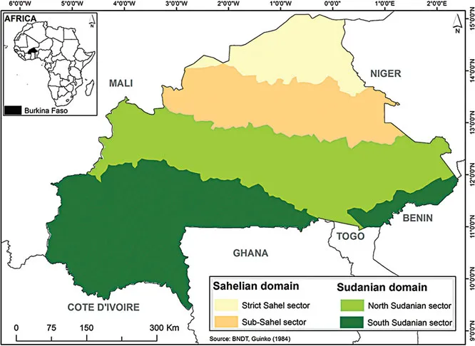
Figure 1.1 Phytogeographical map of Burkina Faso (Source: Guinko, 1984).
Based on annual average rainfall distribution Burkina Faso is divided into three ecoclimatic zones: the Sahelian zone in the northern part of the country, with annual rainfall of 300–600 mm; a transitional Sudano-Sahelian zone in the central region, with a total rainfall of 600–900 mm; and the Sudanian zone in the southern part, with annual rainfall of 900 to 1,100 mm. Therefore, the country’s landscape, vegetation types and species diversity reflected such climate gradient.
Regarding the vegetation, the country is subdivided into two phytogeographic domains (Sudanian and Sahelian domains) and each domain into two sectors (Figure 1.1). The Sudanian domain, which covers the Southern and Central parts of the country includes the South-Sudanian and North-Sudanian sectors. The northern part is covered by the Sahelian domain divided into two sectors (sub-Sahel and strict Sahel) according to the zonation done by Guinko in 1984. These vegetation types range from the shrubsteppe in the northern part, to the islands/patches of dense forests in the southern part of the country.
1.2 Status of Ecosystems in Burkina Faso
In the following paragraphs, the different vegetation types encountered in Burkina Faso from the south to the north are presented based on our own field observations and studies as well as on literature (Guinko, 1984; Ouédraogo, 2006; Ouedraogo et al., 2009; Thiombiano and Kampmann, 2010; Project BKF/015 – IFN 2 et IGB, 2015; Nacoulma, 2012; Gnoumou, 2013; Sambare, 2013; Traoré, 2013; MEEVCC, 2017).
1.2.1 Islands of Dry Deciduous Forests
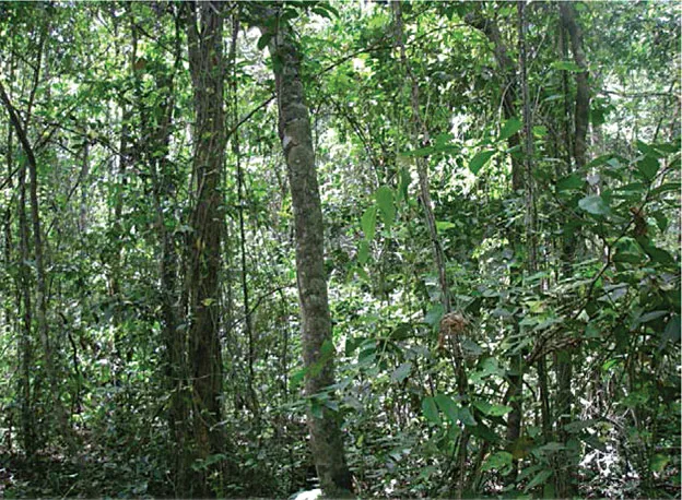
These stands are encountered in the wettest part of the country (southern part) where the annual rainfall can reach 1,000 mm with more than 90 rainy days. The main stands are located in protected areas, particularly in the classified forest and partial wildlife reserve of Comoé Léraba. At the country level, the area of these islands is quite negligible. These islands are the most dense vegetation types found in Burkina Faso (Figure 1.2) with about 1,000 trees or shrubs per hectare and a basal area of 38 m2/ha. The mean total height of trees is 16 m with a rate of cover ranging from 97 to 100% (Gnoumou, 2013). The flora of these particular forests is characterized by a rich group of woody species (Guibourtia copallifera, Gardenia nitida, Strychnos usambarensis, Alafia scandens, Landolphia hirsuta, Dalbergia hostilis, Salacia pallescens, Strophanthus sarmentosus, Ceiba pentandra and Mallotus oppositifolia) as well as herbaceous species (Cissus petiolata, Commelina africana, Commelina subulata, Cyathula prostrata, Cyperus diffusus, Doryopteris kirkii, Elytraria marginata, Malaxis chevalieri, Hibiscus surattensis, Oplismenus hirtellus and Pouzolzia guineensis). These forests are rich in azonal species, which are characteristics of wetter regions and are extremely vulnerable to disturbances such as bushfires and selective harvesting of wood. In unprotected areas, these forests were almost degraded by farmers in favor of farms and other plantations such as the cashew tree (Anacardium occidentale).
Figure 1.2 Islands of dry deciduous forests of Guibourtia copallifera (Photo Credit, Thiombiano A., 2010).
1.2.2 Woodlands
Woodlands occur mainly in the southern part of Burkina Faso with rainfall about 800 to 1,000 mm per year. According to the phytogeographical subdivision, woodlands are essentially confined to the south-Sudanian sector. In the protected areas of the Eastern region, cords of woodlands are found along the drains and valleys at river basins level (Ouédraogo, 2009). Woodlands represent the second most forested type of vegetation in the country (Figure 1.3) with sometimes densities reaching 556 trees per hectare and a basal area of 22 m2/ha (Table 1.1a). The density of juveniles is very heterogeneous. Values can be very variable from one woodland to another one (1,890 to 16,600 individuals/ha). The mean volume of wood is estimated at 28 m3/ha. Woodlands can store up to 52 Mg C/ha (Ouédraogo et al., 2009, Traoré, 2013; MEEVCC, 2017). The mean hei...