
eBook - ePub
Managing Ocean Resources
a Primer
Robert L Friedheim
This is a test
Share book
- 224 pages
- English
- ePUB (mobile friendly)
- Available on iOS & Android
eBook - ePub
Managing Ocean Resources
a Primer
Robert L Friedheim
Book details
Book preview
Table of contents
Citations
About This Book
This comprehensive collection of data and theory provides an essential resource base for intelligent ocean-management decisions. The book begins with essays on ocean science and technology, social and political organization theory relating to the oceans, and some of the problems of extracting energy from the oceans and monitoring oceans from space.
Frequently asked questions
How do I cancel my subscription?
Can/how do I download books?
At the moment all of our mobile-responsive ePub books are available to download via the app. Most of our PDFs are also available to download and we're working on making the final remaining ones downloadable now. Learn more here.
What is the difference between the pricing plans?
Both plans give you full access to the library and all of Perlego’s features. The only differences are the price and subscription period: With the annual plan you’ll save around 30% compared to 12 months on the monthly plan.
What is Perlego?
We are an online textbook subscription service, where you can get access to an entire online library for less than the price of a single book per month. With over 1 million books across 1000+ topics, we’ve got you covered! Learn more here.
Do you support text-to-speech?
Look out for the read-aloud symbol on your next book to see if you can listen to it. The read-aloud tool reads text aloud for you, highlighting the text as it is being read. You can pause it, speed it up and slow it down. Learn more here.
Is Managing Ocean Resources an online PDF/ePUB?
Yes, you can access Managing Ocean Resources by Robert L Friedheim in PDF and/or ePUB format, as well as other popular books in Scienze biologiche & Conservazione e Tutela dell'Ambiente. We have over one million books available in our catalogue for you to explore.
Information
Part I
The Nature of Ocean Space
1
Science and Engineering in the Ocean
Don Walsh is Director of the Institute for Marine and Coastal Studies at the University of Southern California. He specializes in ocean policy, law of the sea, and sea power. He is co-holder of the record for the deepest manned dive to 35,800 feet in the Marianas Trench.
Donald L. Keach is Deputy Director of the Institute for Marine and Coastal Studies at the University of Southern California and Director of the usc sea Grant Program. He specializes in ocean engineering and deep ocean research. Formerly he was Deputy Director of Navy Laboratories and Officer in Charge of Bathyscaph Trieste.
Introduction
Of all the planets in our solar system the one we live on is distinguished by two facts: people live on it, and 71 percent of our planet is covered by water. The Pacific Ocean alone covers 34 percent of our planet or more than all of the land masses put together. Yet man’s misunderstanding of ocean space is such that he gave it the name, “Earth.”
It was not until the astronauts were able to get into space with their cameras that we began to understand the concept of “The Big Blue Marble,” as the children’s television program is so aptly named.
Figure 1.1 shows the earth from several in space, photographed by unmanned satellite over the equator in the Pacific Ocean. The center of the picture is the equator. On the right is the northwestern coast of South America, Colombia, Peru, and Ecuador. Further south is the barren coast of
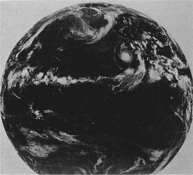
Figure 1.1 Earth Photographed from SEASAT Satellite
Source: National Aeronautics and Space Administration
Chile. To the right of the center is Central America, the Isthmus of Panama, and Mexico. Baja California is top center.
This planet is approximately 4 billion years old. Water was formed about 3.5 billion years ago, but the oceans’ age, determined from dating the sediments beneath the ocean floor, is only about 250–300 million years old.
Science of the Ocean
The average depth of the world ocean is a little over two miles, about 12,000 feet. The deepest place is in the western Pacific Ocean, the Challenger Deep, where the U.S. Navy sent the Bathyscaph Trieste in 1960 35,800 feet, about seven miles (Figure 1.2). However, less than 2 percent of the seafloor is deeper than 20,000 feet.
The total volume of the world ocean is 360 million cubic miles. To give it some meaning or scale, one cubic mile of seawater would hold all of the world’s population, about two billion people today.
The fluid solution that fills the ocean’s volume is water with a little salt. The average salinity (saltiness) of the ocean is about 3.5 percent. In other words, there are 3.5 pounds of salt for every 100 pounds of water.
The chemical oceanographer, who studies the chemical solution we call seawater, is concerned with the ocean’s chemical composition and the interaction of seawater with living organisms as well as its affect on seafloor materials.
In this cubic mile of seawater is a large volume of different basic substances, for example: 2 million tons of potassium, 4 million tons of sulphur, 6 million tons of magnesium, and enough gold to enrich many coffers. Some of these materials are extracted from sea water commercially.
The “bucket” that holds the world ocean is the world of marine geology and geophysics. Throughout the ocean floors of the world there are great systems of mid-ocean ridges and earth valleys, which essentially mark cracks dividing the earth’s surface into six major crustal plates. At the boundaries of these plates the cracks are marked by deep trenches or in other places by subsea mountain ranges which have rift valleys running down their center. The world’s longest mountain range (and
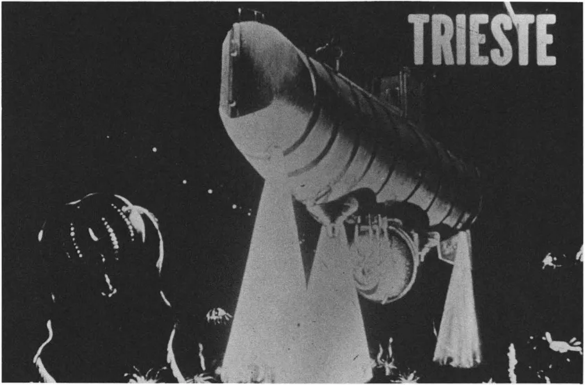
Figure 1.2 Bathscaph Trieste
Source: U.S. Navy
rift valley) is the Atlantic Ocean’s Mid-Atlantic Ridge. This mountain range is nearly 10,000 miles long as it curves around the tip of Africa into the Indian Ocean. Some of the mountain peaks which stick up above the sea surface are known to us as the Canaries, Madeira, Azores Islands.
Iceland sits right on the rift valley, where the seafloor is being formed. Crustal material is forced up from the earth’s interior, then gradually spreads to the east and west. Along the crack of the rift valley is extensive volcanic activity. Iceland’s very active terrain is a surface manifestation of this usually unseen seafloor activity. Occasionally it is seen, as when the entire Island of Surtsey pushed up out of the ocean floor near Iceland before the fascinated gaze of scientists and laymen. Iceland’s hot thermal springs and frequent volcanic eruptions help remind its people that they live on a crack in the earth.
The fact that the ocean floor is so young partially explains why it is continually being formed and destroyed. As the seafloor creeps out toward the continents it moves underneath the continental crustal masses. The continents are much lighter (less dense) than the ocean floor. They “float” on top of the denser ocean floor crust. The ocean floor crust at this point is “recycled” back into the interior of the earth and will appear millions of millions of years later back at the rift valley where it is again pushed out to form new seafloor.
This theory was debated for many years. It could not be proved until we developed a drill ship that could be used for geological research. In the rift valley the rocks and sediments should be very young because they would be newly formed. Moving away from the rift either east or west these materials would get progressively older. This would prove that it is the place of seafloor formation.
The Glomar Challenger a very sophisticated ship operated by the Global Marine Corporation for the National Science Foundation, was able to do this sort of drilling throughout the world along these coastal plate boundaries. They were able to determine the evolution and movement of the plates over the past ten years, and the theories have been proved correct.
The most important part of the ocean floor to us is the continental shelf. From the shoreline to a water depth of about 600 feet at its outer edge, the continental shelf represents only about 8.5 percent of total seafloor area. But there all offshore gas and oil is located, most of man’s fisheries activities are conducted, and most of the pollution damage takes place.
The “continental slope” is the transition slope from the continental shelf to the continental rise, and then finally to the deep ocean floor at an average water depth of about two miles. Here is the province of the physical oceanographer, the scientist who studies currents, waves, and tides,—“the motions of the oceans.” How do the great currents in the world ocean circulate?
Figure 1.3 is a drawing of the major surface currents. Along the U.S. Atlantic coast is the Gulf Stream, the largest and best-known current in the world. It comes up through the Florida straits and along the east coast of the United States before moving away from the coast and across the North Atlantic ocean.
The darker shading is the warmer climate; the white is the coldest water. The Gulf Stream carries the warm tropical water across the North Atlantic to Europe. England and Scotland, far to the north, are kept relatively warm by those bands of warm water from the Gulf Stream.
The surface circulation (currents) of the world ocean are technically called “wind-driven circulation.” In the northern hemisphere, the general circulatin is clockwise; in the southern hemisphere, counterclockwise. The patterns are quite symmetrical.
How does the system work? The planet’s principal energy source, the sun, heats up the ocean. The warm ocean water re-radiates part of this heat back into the atmosphere. In addition, the sun boils off (evaporates) some water from the ocean surface so both heat and moisture are put into the atmosphere, forming clouds and large convective cells of heated air. In the same way the atmosphere is being heated from the bottom by the solar energy that has been absorbed by the seawater. Water has great storage capacity for heat energy.
The sun stores up the heat in the ocean rather quickly, the ocean re-radiates that heat rather slowly, and vertical circulation of air above the ocean begins. As heated air rises from the sea surface it is replaced by cooler air drawn in along the sea surface. The friction of the air rubbing along the sea surface creates surface waves and currents.
Some of the water that is carred into the atmosphere goes over land, forms clouds, and falls
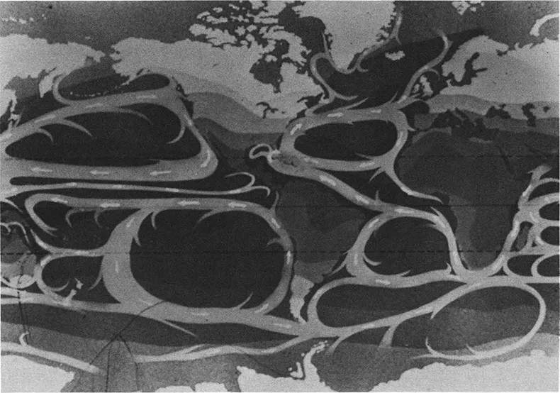
Figure 1.3 Major Ocean Surface Current
Source: U.S. Navy
out as fresh water. Most of it eventually returns to the sea in a continuous cycle. We call this process “the hydrologie cycle.” Water used on land for man’s needs also carries pollutants, nutrients, and other substances from the land back into the sea.
The importance of “the great river in the sky” is demonstrated by the fact that nearly two-thirds of all the rain, or precipitable water, that falls east of the Rockies in the United States comes from the Gulf of Mexico. This atmospheric flow of warm, moist air crosses the Gulf Coast of the southern United States, flows into the central plains states, and then falls out as water when atmospheric weather conditions are right to form rain.
The giant vertical circulations of this “boiling atmosphere” heated from below by the oceans, combined with the rotation of our planet, creates planetary winds. These permanent winds flow in fixed directional patterns across the ocean’s surface. In many regions the wind blows from one direction all year round with a very steady velocity, for example, the “trade winds.” As that wind pushes on the water surface, it moves and the surface circulation patterns, “the wind-driven circulation,” begin.
As noted earlier, the global surface circulation also acts as a giant global thermostat. The tropics have excess heat and excess energy. There needs to be some natural mechanism to keep this region from heating up. We know its density from weather records that go back hundreds of years. The earth’s temperature fluctuates very little over long periods of time.
The circulation of the ocean and atmosphere act as a natural mechanism (a kind of global-basic hot water central heating system). The boiler is in the tropics, the surface current circulations are piping, carrying heat up into parts of the planet where there is a heat deficit, such as the polar and subpolar regions. Heat is slowly released whenever the circulation enters a cooler region. The great wind-driven circulation is also a way of distributing, primarily through the circulating water, the earth’s heat throughout the planet to keep the planet’s climate in balance.
While the oceans’ surface waters are important to man, there are other, more complex deep current circulations in the oceans. These are the “density” currents.
Seawater in the oceans has varying degrees of buoyancy which are influenced by its temperature and salinity. More cold and more salt make heavier water. Cold, salty water is very heavy, and when it flows out into the ocean it tends to sink to the bottom. These flows are density currents—deep, very slow-moving currents propelled by gravity as the heavy waters try to flow “downhill.” The principal source of deep-density currents is the Antarctic, where very cold salty water is formed in the Weddell Sea. It sinks to the bottom and moves along the floor of the Atlantic and Pacific, flowing slowly north with remarkable extent. Remnants of “Antarctic Water” can be found at the bottom of the Gulf of Mexico. Another major source is in the straits between Labrador and Greenland.
A specialized case is the very warm Mediterranean Sea. As the sun evaporates the fresh water from its surface, not cold, but very salty water, is left. The heavy saline water sinks to the bottom of the Mediterranean, flows along the sea floor and out over the sill at Gilbraltar. Fresh Atlantic water flows in at the top, which in turn is “boiled off,” becomes heavy and flows back out at the bottom. This is a good example of a deep, as opposed to wind-driven, circulation.
There is another important circulation, more localized, called “upwelling.” It is found in certain coastal areas where the winds blow parallel to shore. Generally the coastal wind blows the surface layer away. Water from beneath comes up to replace the water that has been blown off at the top. The deep water is full of nutrients such as heavy dissolved minerals and organic matter. They gradually sink to the bottom, where there are few animals to consume them. When circulated, this “deep water” and its contents become the ocean’s food supply. “Recycling” through this vertical circulation provides surface waters that are extremely rich in nutrients, capable of supporting a high degree of biological activity.
Upwelling areas are not found everywhere in the world, but in places are very prominent, such as off the west coast of South America. Peru often ranks as one of the largest fishing nations in the world by catch tonnage, not because they have a high technology fishing industry but because of the hugh catch of anchovy within a few miles of the Peruvian coast.
The life cycle in the sea begins with sunlight, which stimulates the growth of microscopic plankton plants called phytoplankton—“grass of the sea.” The next larger plankton are called “Zooplankton”—microscopic animals which feed on that “grass.” Thus the “food chain” begins. Fish such as the herring, anchovy, and smelt feed directly on the plankton; they are in turn eaten by other fish, and so on. Figure 1.4 is a graphic example of the food chain.
This figure shows what it takes to put one pound of weight on a person. It takes 10,000 pounds of phytoplankton, the microscopic plants, to make a half ton of Zooplankton. And it takes a half ton of Zooplankton to make 100 pounds of anchovy. The anchovy in turn will make ten pounds of tuna which finally makes one pound of person. In other words, there is a ten-to-one reduction at each stage of the food chain.
Let us now consider where people prefer to live and relate that to those areas of the oceans that are usually the areas of greatest value and human activity. Historically pooulation clusters have concentrated near lakes, river valleys, and coastlines. There are many reasons for this, including ease of transportation, availability of food from the waters, recreational opportunities, and usually better weather than foud inland.
Ocean areas of greatest interest tend to be on and near the continental shelf areas of the ocean world. Until we begin to exploit the minerals of the deep ocean or find “exotic” biological biological resources there, man has comparatively few interests in the open oceans. They are, for example, not that productive for fisheries. The waters over the continental shelves are generally more productive in biological resources and the land beneath for oil and gas. Because these areas are near the coast and therefore accessible to large populations, we also find a high level of pollution. One of our most serious problems is the competition for use of the same areas on and over the continental shelf for fishing, producing oil and gas, shipping, recreation, and dumping grounds.
Studying the Sea
Man’s interest, formal and informal, in the oceans goes back centuri...