eBook - ePub
The Irish tower house
Society, economy and environment, <i>c.</i> 1300–1650
- 278 pages
- English
- ePUB (mobile friendly)
- Available on iOS & Android
eBook - ePub
About this book
This book examines the social role of castles in late-medieval and early modern Ireland. It uses a multidisciplinary methodology to uncover the lived experience of this historic culture, demonstrating the interconnectedness of society, economics and the environment. Of particular interest is the revelation of how concerned pre-modern people were with participation in the economy and the exploitation of the natural environment for economic gain. Material culture can shed light on how individuals shaped spaces around themselves, and tower houses, thanks to their pervasiveness in medieval and modern landscapes, represent a unique resource. Castles are the definitive building of the European Middle Ages, meaning that this book will be of great interest to scholars of both history and archaeology.
Trusted by 375,005 students
Access to over 1.5 million titles for a fair monthly price.
Study more efficiently using our study tools.
Information
1
Around the castle wall: The tower house complex and rural settlement
The ‘revisionist’ approach to castles, starting in the 1970s, has sought to place them within their managed environment. In this way, features such as formal gardens have been identified, and the symbolism of deer parks in particular, but dovecotes, rabbit warrens and artificial fishponds have also been discussed. The relationship of the castle to that other local landscape feature, the dependent settlement, has similarly been of interest (Creighton and Barry, 2012; Murphy and O’Conor, 2006). Arguably, this tradition of an integrated landscape study has a longer history in England than in Ireland. This is in no small part because extensive investigation of the immediate landscape context of tower houses has been hampered by a lack of material evidence. However, there is a significant body of work on different facets of Ireland's rural landscape, including study of medieval rural settlement. O’Conor (1998) has noted that since we see castles today as isolated in the landscape, we tend to lack the imagination to envisage how this was not always the case. Tower houses, too, have a tendency to be regarded as solitary within the landscape, a view assisted by the disappearance of the buildings that undoubtedly stood around many of them. Oram (2010) has gone so far as to say that castle scholars have misconceived these associated buildings as later additions, thus further obscuring the real picture.
Likewise, there is a long history in Ireland of investigation of deserted medieval, or post-medieval, settlements, commonly referred to as ‘deserted medieval villages’ (DMVs).1 Newtown Jerpoint, County Kilkenny, is probably the most famous and intensively studied DMV, but notable attention has also been paid to Piperstown in County Louth, Newcastle Lyons in County Dublin and to Rindoon in County Roscommon. An added complexity to the study of rural settlement in Ireland is that we cannot presume that all of it was nucleated. In fact, it is very likely that a significant proportion of the population of medieval Ireland, especially in Gaelic-Irish areas, lived in dispersed settlement. Even in the old Anglo-Norman areas there have been suggestions that Gaelic-Irish tenants lived separately from the main manorial settlement, in so-called betagh settlements on the outskirts of town lands, or in more isolated farmhouses.
Evidence is for a diversity of rural settlement forms neighbouring tower houses. The argument for a nucleating effect of tower houses, even in more sparsely populated Gaelic-Irish areas, is particularly convincing. In fact, the social differences between the Anglo-Irish and the Gaelic-Irish may be overstressed (O’Conor, 1998). That tower houses were constructed and occupied by both ethnicities with minimal (if any) architectural distinctiveness is testament to the tower house's unique role as a settlement form transcending common medieval social signifiers. It also suggests a shared material culture. Here, the tower house parallels the parish church, which is commonly studied in other European and British contexts as a built form transcending other divides (ibid.).
We need to view the castle and the landscape and settlement features in its vicinity as interconnected, and that is the approach of this chapter in examining the rural landscape elements surrounding the tower house. It broadens this territorial scope in stages, starting with the buildings we might find next to the tower itself, as components of a larger complex. Each tower house will have drawn from a personal hinterland; and in rural Ireland most likely from peasants or farmers toiling the land for their lord. Therefore, we can use the tower house as a starting point for uncovering ordinary people, and to study the socio-economics that nurtured it.
No solitary tower: The immediate castle complex
The small size of many tower houses combined with the varied social status of their inhabitants has led to the suggestion that the stone tower was merely the centre of a much larger complex, with not all functions housed within the tower (Creighton and Barry, 2012; O’Conor, 1998; Oram, 2010; Tabraham, 1997). The cabins recorded in such sources as the Civil survey probably resembled the small, rounded and windowless structures depicted by Richard Bartlett in Bird’s-eye view of Armagh city; Map of the fort at Mountnorris, between Armagh and Newry; and the Rath at Tullaghoge with the nearby stone inaugural chair of the O’Neills (NLI, MS 2656). Some evidence for buildings has come from excavation, and new non-invasive techniques are revolutionising our comprehension of what lay around the castle. Two case studies illustrating some of the methodology are employed: Ardmayle and Ballynahinch, both in County Tipperary. Combining this information with historical sources, we can achieve greater knowledge of the activities taking place in proximity to tower houses.
Preservation is a major problem though, as ancillary buildings were often constructed of impermanent materials. Based on his study of tower house halls, Sherlock comments that ‘the free-standing hall was a “soft building”, in the sense that it was constructed of materials other than stone and slate and it is important to acknowledge that physical evidence for such structures may be found only, if at all, through excavation’ (Sherlock, 2015: 105). Constructions made of impermanent and organic materials – such as peasant housing or buildings of secondary importance to the masonry tower house – frequently do not survive in the archaeological record. The contemporary historical and cartographical record for Ireland is similarly lacking in precise details. In terms of documentary evidence, aside from a few notable writers, such as Luke Gernon, Richard Stanihurst and the Gaelic bardic poets, the appearance of castles and the impression they made on those who saw them are little discussed (Barry, 2006). As a useful visual source concerning dependent settlement at castles, however, we have early modern campaign maps from English military actions in Ireland, the best known and most useful of these drawn by Bartlett.
Evidence provided by excavation is often lacking. Barryscourt Castle in County Cork is one of the very few tower houses that has had the area within its bawn excavated. The results suggested that the tower house and an associated kitchen building were constructed at the same time. A further building located against the bawn wall was interpreted as a gallery or hall, and there may have been an enclosed garden. The excavation did not seek to uncover the whole bawn area, so the finds are incomplete. Of interest, however, is the presumption by the excavators that most of the enclosure was occupied by farm buildings (Pollock, 2004). Excavations at Kilcolman Castle, County Cork, again targeted a limited area of the bawn, but tentative conclusions were drawn about its use, including that it had housed cattle (Klingelhofer, 2010). Buildings in the southern part of the bawn were identified, suggested to be a great hall, parlour, kitchen and other service buildings (ibid.). Comparative evidence from tower house excavations in Scotland does not provide much additional data. For example, excavations at Threave Castle in southwest Scotland only uncovered two additional buildings. One of these was interpreted as a hall, while the other structure as providing additional lodging and a chapel. As at Barryscourt, there were probably other ancillary buildings not exposed (Tabraham, 1997, 1998). Halls, kitchen blocks with service roles (for example, bakehouses and brewhouses) and chapels are the buildings most commonly found in association with tower houses in Scotland (Oram, 2011). As in Ireland, the limits of excavation mean these results are tentative, necessitating scholars of Scottish settlement to use interdisciplinary methods to recreate what once stood at the isolated towers (Oram, 2010). Another restriction is that determining function based solely on building foundations is very problematic, as use is often ascribed based on only scale, dimension and orientation (Oram, 2011; Tabraham, 1998).
Identification has furthermore been hampered by the low resolution of aerial imaging at many tower house sites, while lidar and three-dimensional imaging remain prohibitively expensive. An alternative is the digital elevation models (DEMs) that can be generated from drone-based survey. Two sites surveyed have returned potentially exciting results. Drone surveys were completed in winter 2017 at Ballynahinch and Ardmayle. Both sites have historical documentation attesting to the existence of burgesses in the same townland as the tower house. Ardmayle (figure 1.1) is described by Glasscock in his gazetteer of deserted Anglo-Norman settlement sites as being a small settlement outside Cashel on the east side of the Suir River, with the remains of a motte and medieval church. He even went so far as to describe it as the ‘perfect river-side site for Norman burgage settlement’ (Glasscock, 1971: 295). Ardmayle motte is located around two hundred metres north of the tower house, with a medieval parish church across the modern road from the tower house. In 1212 it was documented as having a recently constructed mill, granary, ditches and bridge (Davies and Quinn, 1941; Hennessy, 1996).
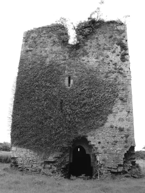
1.1 Ardmayle Castle, County Tipperary, is located in a shrunken settlement complex, along with a medieval parish church and motte castle. It has been the subject of drone-based investigations.
In 1305, probably before the tower house was built, Ardmayle was valued at over £34, making it at a minimum an important manor and borough (Hennessy, 1988, 1996). This 1305 extent, enumerating the assets of the landholding, states that there were burgesses who paid £17 3s. 3d. for their land, as well as two mills with fishing weir (gurgitibus), a town oven and a warren (Red book of Ormond). The surviving extent for Ardmayle records that the motte castle was located beside the ‘curia’, or the buildings comprising the manorial centre, the buildings serving partly residential and partly agricultural purposes (Murphy, 2015). Next to the curia was the garden, which may have been more akin to an orchard as the terms were used interchangeably (ibid.). An inquisition taken in 1338 states that there were no buildings in the manor and only a handful of free tenants and burgesses. The only features generating any revenue were a dovecote, a rabbit warren and a leased-out fish weir, as two water mills with fisheries were in disrepair (Inquisitions and extents). In total, the manor was valued at £20 15s. 3d., showing that it had declined considerably over the opening decades of the fourteenth century. That the tower house was later constructed suggests that some prosperity returned after the difficulties of that century, as by the time of the Civil survey it is recorded as a ‘good’ castle with several other small cabins (Civil survey: vol. 1).
The agricultural area by the castle was often referred to as a ‘haggard’, and could have been used for grain storage in lieu of a granary building. Many haggards were surrounded by ditches or walls and could be sizeable areas, potentially even larger than the rest of the curia (Murphy, 2015). Based on such documentary references, such an enclosure could, from an archaeological perspective, physically resemble a bailey, bawn or moated site, which complicates the identification of features based on fieldwork. One is described at Caherconlish in County Limerick, where houses were located on both sides of the enclosing ditches (ibid.).
If we compare the DEM-identified patterns at Ardmayle (see figure 1.2) to Lisronagh in County Tipperary, then some conclusions might be drawn. At Lisronagh there is also a medieval parish church around one hundred metres to the north of ...
Table of contents
- Cover
- Half-title page
- Series page
- Title page
- Copyright page
- Contents
- Figures
- Acknowledgements
- Introduction
- 1 Around the castle wall: The tower house complex and rural settlement
- 2 The medieval agrarian economy: Lifeblood of the tower house
- 3 Rivers in pre-modern Ireland: Environment and economy
- 4 Movement, transport and communication: Tower houses and waterways
- 5 ‘Urban’ tower houses
- 6 Tower houses, late medieval Ireland and the connection with the wider world
- Conclusion: The social, economic and environmental contexts of the Irish tower house
- Appendix: Sites referred to in text
- References
- Index
Frequently asked questions
Yes, you can cancel anytime from the Subscription tab in your account settings on the Perlego website. Your subscription will stay active until the end of your current billing period. Learn how to cancel your subscription
No, books cannot be downloaded as external files, such as PDFs, for use outside of Perlego. However, you can download books within the Perlego app for offline reading on mobile or tablet. Learn how to download books offline
Perlego offers two plans: Essential and Complete
- Essential is ideal for learners and professionals who enjoy exploring a wide range of subjects. Access the Essential Library with 800,000+ trusted titles and best-sellers across business, personal growth, and the humanities. Includes unlimited reading time and Standard Read Aloud voice.
- Complete: Perfect for advanced learners and researchers needing full, unrestricted access. Unlock 1.5M+ books across hundreds of subjects, including academic and specialized titles. The Complete Plan also includes advanced features like Premium Read Aloud and Research Assistant.
We are an online textbook subscription service, where you can get access to an entire online library for less than the price of a single book per month. With over 1.5 million books across 990+ topics, we’ve got you covered! Learn about our mission
Look out for the read-aloud symbol on your next book to see if you can listen to it. The read-aloud tool reads text aloud for you, highlighting the text as it is being read. You can pause it, speed it up and slow it down. Learn more about Read Aloud
Yes! You can use the Perlego app on both iOS and Android devices to read anytime, anywhere — even offline. Perfect for commutes or when you’re on the go.
Please note we cannot support devices running on iOS 13 and Android 7 or earlier. Learn more about using the app
Please note we cannot support devices running on iOS 13 and Android 7 or earlier. Learn more about using the app
Yes, you can access The Irish tower house by Victoria L. McAlister in PDF and/or ePUB format, as well as other popular books in Social Sciences & European Medieval History. We have over 1.5 million books available in our catalogue for you to explore.