![]()
Chapter 1
Introduction
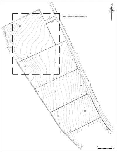
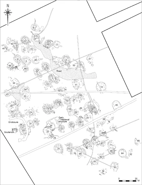
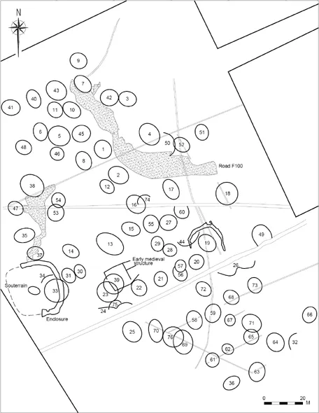
A total of 76 Bronze Age structures, including 74 roundhouses, were discovered at Corrstown, Co. Londonderry (site centre NGR 28609 43914), representing a site which is hitherto unique in the archaeological record of the British Isles (Illustrations 1.1–1.5). A number of additional contemporary features included a large cobbled road surface and numerous cobbled pathways as well as dispersed postholes and pits. Early medieval activity was represented by a ringfort, a rock-cut souterrain and a large square structure. A Neolithic presence on the site was represented by a small pottery assemblage.
1.1 Background to the archaeological excavation
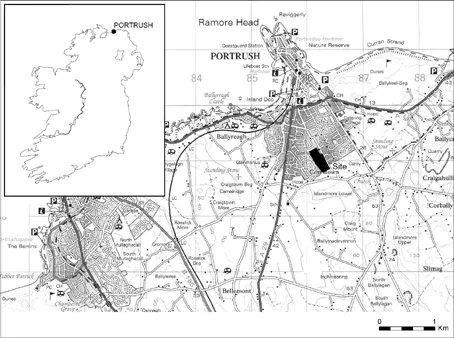
In 2001 and early 2002 small test excavations were carried out under the direction of Malachy Conway for Archaeological Consultancy Services Ltd (ACS) in the townland of Corrstown at the southern limits of the small town of Portrush, Co. Antrim, on the north coast of Northern Ireland. Portrush is typical of many towns along the north Antrim coast which were major tourist destinations in the late 19th and early 20th centuries but which have suffered from the mid-20th century onwards, partly due to the development of the overseas tourist market and partly as an effect of The Troubles in Northern Ireland which dissuaded holiday-makers from visiting the area. Following the cessation of violence in the mid 1990s Portrush, the adjacent coastal town Portstewart, and the larger inland town, Coleraine, began a significant period of redevelopment, based on re-invigorated tourism and the influx of students to the University of Ulster Coleraine Campus. Large housing and commercial developments were built in all three towns and archaeological investigations took place in advance of these developments, identifying and recording numerous new archaeological sites. The test excavations at Corrstown (Licence Number AE/01/82) were undertaken in advance of the construction of c. 200 new houses in four adjacent fields, representing a large sub-rectangular block of land measuring approximately 600m in length (north–south) and between 150m and 190m in width (east–west), giving a total area of 7.4 hectares. The area of excavation was delimited by pre-existing housing along its western and northern boundaries and the northern part of its eastern boundary along Hopefield Road. That the site had great archaeological potential was already known, as a large circular enclosure had been recorded in aerial photographs of the site and the enclosure was listed on the Sites and Monument Record (SMR LDY 003:26). In addition, excavations had been carried out in 1999 in the adjacent townland of Magheramenagh, immediately to the west of the Corrstown site. These excavations were carried out by Alan Reilly for Northern Archaeological Consultancy Ltd in advance of an earlier housing development and had uncovered several prehistoric houses, a sizeable early medieval souterrain and a large number of pits, postholes and other features (Reilly 2000, 130).
The archaeological testing of the Corrstown site was undertaken in two phases, the first of which comprised a fluxgate gradiometer survey conducted in order to locate the previously recorded enclosure. Phase 1 also incorporated the collection of artefacts from the ploughed surface of the fields, the excavation of four archaeological test trenches, and the archaeological monitoring of four engineering test pits. The fluxgate gradiometer survey successfully identified the enclosure, as well as several other features, including at least one possible souterrain. The second phase of archaeological testing included the excavation of 22 archaeological test trenches, further collection of artefacts from the ploughed surface, and the archaeological monitoring of topsoil removal in the two southernmost fields. The results of both testing phases indicated the presence of significant numbers of archaeological features in only two of the four fields, although large quantities of lithic material were recovered from the topsoil across the whole site. This indicated that the site had been heavily ploughed and suggested that the archaeological features may have become truncated as a result, a process confirmed during excavation. At this stage, a sizeable prehistoric occupation site was discernable, as well as evidence for an early medieval settlement. A full excavation of the archaeological features was scheduled for the later part of 2002 to be funded by the developer of the housing scheme, The Kennedy Group Plc.
1.2 Surprising results
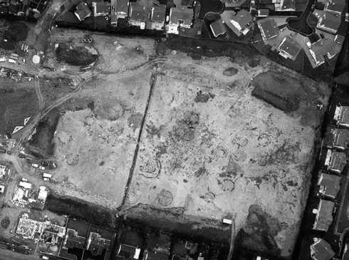
In October 2002 a small team of archaeologists consisting of the site director Malachy Conway, site supervisor Stuart Rathbone, and four site assistants arrived in Portrush to begin excavation of the small prehistoric settlement and the early medieval ringfort (Licence Number AE/02/100). Topsoil stripping began in the approximate centre of where the prehistoric settlement was deemed to be located and several large circular buildings were revealed. As excavation began on the first structures, Structures 1–4, topsoil stripping continued, slowly expanding the excavation area on all sides. Each day new building foundations were revealed and the estimated total number of buildings present was constantly being revised upwards. After several weeks of topsoil stripping it was clear that the settlement consisted of many more buildings than could have ever been expected and that the site was of far greater complexity and scale than had been previously envisaged for the Irish Bronze Age. It was clear that the assembled archaeological team was much smaller than was needed and while progress had been made with the first six buildings uncovered a considerably larger team would be required if the site was to be completed within the next decade! Late in December 2002 the number of identified houses had risen to above 30 and several emergency meetings were held between the developer The Kennedy Group Plc, the management of ACS, and various members of the archaeological staff at the Northern Ireland Environment Agency. In December 2003 the excavation team was increased by the addition of two new site supervisors, Chris Conway and Maria Lear, along with the addition of 15 new site assistants.
With increased team members excavations proceeded at a greater pace and progress on site could be measured on a daily basis, despite the incredibly hostile winter with its seemingly constant heavy rain and daily hailstorms. The level of the truncation and the effect it had on the extant archaeological evidence varied across the site. Early modern field boundaries and pipe drains also traversed the site and had an adverse effect on the archaeological remains, often obscuring and truncating the structures. Topsoil stripping continued throughout the early spring and it was then that the extent of the settlement was eventually revealed. In June 2003 Malachy Conway left the excavation in order to take up a position with the National Trust for Northern Ireland, and the rest of the excavation was directed by Audrey Gahan of Gahan and Long Ltd. Excavations at the site were finally completed in late August 2003 and all involved were aware that, at least in some small way, the Irish Bronze Age would never look the same again.
1.2.1 Bronze Age occupation
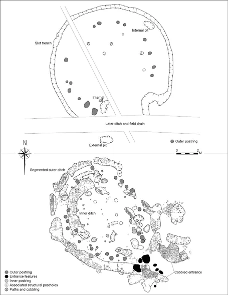
The excavated structures, described in Chapter 2, were oval or circular in shape and as such were classified as roundhouses (Illustrations 1.3–1.4). Large quantities of domestic pottery were recovered from most of the structures which suggested that they had functioned as houses. Seventy four of these roundhouses were revealed along with several more irregular groups of features, the exact nature and function of which have still not been established. Although a small number of the buildings were of a well-known Bronze Age type defined by a circular slot-trench with vertical sides and an internal postring (described in this volume as Type 2), the majority were of a type that had not been previously recognised (described in this volume as Type 1) (Illustration 1.6). These consisted of wide ditches of a peculiarly segmented form and a multitude of pits and postholes that formed no easily interpretable pattern. Several of the buildings consisted of concentric rings of these segmented ditches and one stood within a deep horseshoe-shaped enclosure. Some of the buildings were clearly grouped into pairs or short rows. Many of the buildings had long, sunken porches flanked by pits and postholes, with fine cobbling covering the base. Long, sunken pathways connected some of the entrances together and the bases of these pathways were also covered in the same fine cobbling. A large, roughly cobbled road surface (over 70m in length by 10m in width) ran through the eastern side of the settlement. A second un-surfaced road was suspected to be present along the western side of the site; it was defined by an absence of features in this area.
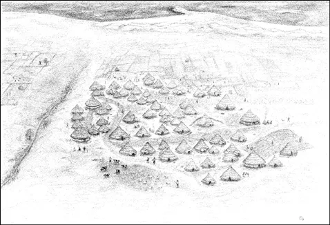
The manner in which the houses were connected by pathways and grouped into pairs and rows, as well as the very rare occurrence of individual buildings overlapping each other, suggested that much of the settlement was occupied contemporaneously. Twenty-four radiocarbon dates were obtained from 22 of the roundhouses and the dates were found to be tightly clustered in the Middle Bronze Age, supporting the excavation team’s impression that the majority of the buildings would have been in use at the same time, and that what had been excavated was the first indisputable evidence in Ireland and Britain of a large Bronze Age village. A reconstruction of the village is shown in Illustration 1.7 (no evidence for field systems was forthcoming from the excavations but these have been included by the reconstruction artist. A view to the sea from the site was discovered using Google Earth).
The artefact assemblage from the site was dominated by pottery and lithics. Over 9,000 sherds of mainly undecorated pottery were collected and identified by Helen Roche and Eoin Grogan. The pottery represents a highly significant assemblage of a newly recognised plain domestic ware, dating from the Middle Bronze Age, and deriving from the cordoned urn tradition. Bipolar reduced flint artefacts were recovered in such large quantities that it was not possible to assign a separate artefact number to each piece but it is estimated that over 16,500 pieces were collected. A sample comprising 65% of the total assemblage has been analysed by Maria O’Hare, and it represents one of the largest assemblages of Middle Bronze Age flint that has currently been examined in Ireland. Four stone moulds, two complete polished stone axes, five polished stone axe fragments, and a large polished stone macehead were recovered from the site, along with four stone moulds for casting bronze objects. Despite the presence of the moulds no metal artefacts were recovered and no slag was identified. These more elaborate stone artefacts were examined by Eoin Grogan and Stephen Mandal.
Unfortunately, animal bone – either burnt or otherwise – was almost completely lacking from the excavations. Therefore, little information regarding the diet or farming practices of the inhabitants was discerned, although a small quantity of carbonised seeds from the Bronze Age occupation was recovered. No waterlogged deposits were discovered that would allow for the preservation of organic material, although a small number of burnt stakes and timbers were discovered. No human bone was recovered from the site and it is not known if it was originally excluded from the site or has simply not survived. The reason for the poor representation of plant macrofossils, bone and metal artefacts from the site may be partly linked to post-depositional processes and to the general acidic soil environment in the area, both of which appear to have been significantly affected by the arable farming undertaken across the site over the recent decades and even centuries.
1.2.2 Early medieval occupation
In addition to the Bronze Age settlement the early medieval ringfort was fully excavated, along with a small partially rock-cut souterrain which was located in the interior. An unusual set of shallow ditches that formed a large rectangular arrangement possibly represented the foundations for a building and also dated to this period. It was associated with a large number of carbonised seeds which may indicate that it had a crop-processing or storage function. An early medieval kiln was also identified and excavated.
1.3 Post-excavation processing
The completion of the Corrstown excavations was a major achievement, but as with any excavation of this scale the fieldwork was only one part of a large and complicated process that would lead to the eventual publication of the results. In the years following the excavations, the stratigraphic report was slowly compiled, the massive artefact assemblage was processed and analysed, the environmental samples were studied, and the large archive of drawings was digitised and prepared for eventual publication. In 2004 the Council of British Archaeology recognised the importance of the site and the quality of the work that was undertaken. The excavations received a commendation for high standards in commercial archaeology at the annual British Archaeology Awards, held that year at Queen’s University Belfast. An initial account of the site was published the following year in Current Archaeology as part of the coverage of the awards (Conway et al. 2004) which complemented the summary accounts in Excavations Bulletin (Conway 2003, 2004). A further, succinct account was published in Archaeology Ireland in 2006 (Conway 2005). A brief discussion of the site was also included in Cleary’s article discussing Irish Bronze Age settlements (Cleary 2006, 20). Details of each of the Bronze Age buildings and a limited account of the site have been included in John Ó Néill’s recent Inventory of Bronze Age Structures prepared on behalf of the Heritage Council (Ó Néill forthcoming). In 2010 a summary account of the excavation report was also included in the Northern Ireland Environment Agency’s inventory of recent archaeological discoveries in Northern Ireland (Conway 2010).
A major milestone for the project was the submission of the full stratigraphic report for the site to the Northern Ireland Environment Agency, in 2008 (Conway et al. 2008); however, there was no illusion that that report could simply be reproduced for publication, primarily due to its size. It should be noted that the original post-excavation budget was entirely spent, and much more besides, on simply obtaining specialist reports detailing the artefacts and ecofacts and that publication of the results had not formed part of the original contract. Efforts were made to secure funding for the publication and The Heritage Council Ireland granted funding for the production of an education pack based on the site. This was compiled and freely distributed to schools and education bodies in Northern Ireland and in the border counties in the Repu...