Because of its natural wealth, India has long been a tempting prize for invaders, yet foreign forces such as the Mughal Empire and the British did not destroy India's vibrant spirit. Rather, external influences often became absorbed into the mix of different peoples, languages, religions, and regional traditions, creating a lasting culture of great depth. This book recounts the history of India and much of present-day Pakistan and Bangladesh as well as the factors that have contributed to India's epic economic successes in recent times. Memorable images texture the narrative and vividly animate the story of this unique nation.
- English
- ePUB (mobile friendly)
- Available on iOS & Android
eBook - ePub
The History of India
About this book
Trusted by 375,005 students
Access to over 1.5 million titles for a fair monthly price.
Study more efficiently using our study tools.
Information
Subtopic
Indian & South Asian HistoryIndex
HistoryCHAPTER 1
THE BEGINNINGS OF INDIA’S HISTORY
The Indian subcontinent, the great landmass of South Asia, is the home of one of the world’s oldest and most influential civilizations. In this book, the subcontinent, which for historical purposes is usually called simply “India,” is understood to comprise the areas of not only the present-day Republic of India but also the republics of Pakistan (partitioned from India in 1947) and Bangladesh (which formed the eastern part of Pakistan until its independence in 1971).
Since early times the Indian subcontinent appears to have provided an attractive habitat for human occupation. Toward the south it is effectively sheltered by wide expanses of ocean, which tended to isolate it culturally in ancient times, while to the north it is protected by the massive ranges of the Himalayas, which also sheltered it from the arctic winds and the air currents of Central Asia. Only in the northwest and northeast is there easier access by land, and it was through those two sectors that most of the early contacts with the outside world took place.
Within the framework of hills and mountains represented by the Indo-Iranian borderlands on the west, the Indo-Myanmar borderlands in the east, and the Himalayas to the north, the subcontinent may in broadest terms be divided into two major divisions: in the north, the basins of the Indus and Ganges (Ganga) rivers (the Indo-Gangetic Plain) and, to the south, the block of Archean rocks that forms the Deccan plateau region. The expansive alluvial plain of the river basins provided the environment and focus for the rise of two great phases of city life: the civilization of the Indus valley, known as the Indus civilization, during the 3rd millennium BCE; and, during the 1st millennium BCE, that of the Ganges. To the south of this zone, and separating it from the peninsula proper, is a belt of hills and forests, running generally from west to east and to this day largely inhabited by tribal people. This belt has played mainly a negative role throughout Indian history in that it remained relatively thinly populated and did not form the focal point of any of the principal regional cultural developments of South Asia. However, it is traversed by various routes linking the more-attractive areas north and south of it. The Narmada (Narbada) River flows through this belt toward the west, mostly along the Vindhya Range, which has long been regarded as the symbolic boundary between northern and southern India. The northern parts of India represent a series of contrasting regions, each with its own distinctive cultural history and its own distinctive population. In the northwest the valleys of the Baluchistan uplands (now largely in Balochistan, Pak.) are a low-rainfall area, producing mainly wheat and barley and having a low density of population. Its residents, mainly tribal people, are in many respects closely akin to their Iranian neighbours. The adjacent Indus plains are also an area of extremely low rainfall, but the annual flooding of the river in ancient times and the exploitation of its waters by canal irrigation in the modern period have enhanced agricultural productivity, and the population is correspondingly denser than that of Baluchistan. The Indus valley may be divided into three parts: in the north are the plains of the five tributary rivers of the Punjab (Persian: Panjab, “Five Waters”); in the centre the consolidated waters of the Indus and its tributaries flow through the alluvial plains of Sind; and in the south the waters pass naturally into the Indus delta. East of the latter is the Great Indian, or Thar, Desert, which is in turn bounded on the east by a hill system known as the Aravali Range, the northernmost extent of the Deccan plateau region. Beyond them is the hilly region of Rajasthan and the Malwa Plateau. To the south is the Kathiawar Peninsula, forming both geographically and culturally an extension of Rajasthan. All of these regions have a relatively denser population than the preceding group, but for topographical reasons they have tended to be somewhat isolated, at least during historical times.
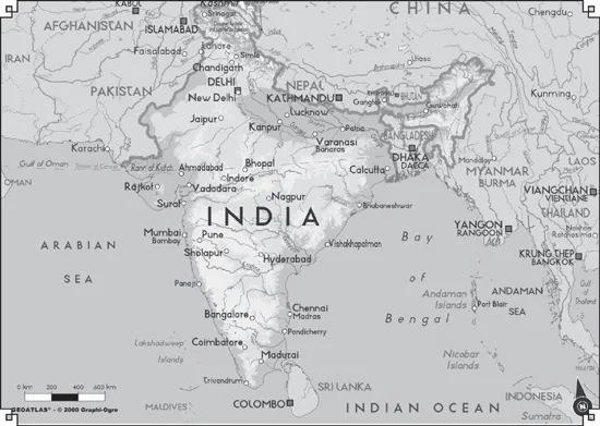
This map of India shows its major geographic features. © GeoAtlas
East of the Punjab and Rajasthan, northern India develops into a series of belts running broadly west to east and following the line of the foothills of the Himalayan ranges in the north. The southern belt consists of a hilly, forested area broken by the numerous escarpments in close association with the Vindhya Range, including the Bhander, Rewa, and Kaimur plateaus. Between the hills of central India and the Himalayas lies the Ganges River valley proper, constituting an area of high-density population, moderate rainfall, and high agricultural productivity. Archaeology suggests that, from the beginning of the 1st millennium BCE, rice cultivation has played a large part in supporting this population. The Ganges valley divides into three major parts: to the west is the Ganges-Yamuna Doab (the land area that is formed by the confluence of the two rivers); east of the confluence lies the middle Ganges valley, in which population tends to increase and cultivation of rice predominates; and to the southeast lies the extensive delta of the combined Ganges and Brahmaputra rivers. The Brahmaputra flows from the northeast, rising from the Tibetan Himalayas and emerging from the mountains into the Assam valley, being bounded on the east by the Patkai Bum Range and the Naga Hills and on the south by the Mikir, Khasi, Jaintia, and Garo hills. There is plenty of evidence that influences reached India from the northeast in ancient times, even if they are less prominent than those that arrived from the northwest.
Along the Deccan plateau there is a gradual eastward declivity, which dispenses its major river systems—the Mahanadi, Godavari, Krishna, and Kaveri (Cauvery)—into the Bay of Bengal. Rising some 3,000 feet (1,000 metres) or more along the western edge of the Deccan, the escarpment known as the Western Ghats traps the moisture of winds from the Arabian Sea, most notably during the southwest monsoon, creating a tropical monsoon climate along the narrow western littoral and depriving the Deccan of significant precipitation. The absence of snowpack in the south Indian uplands makes the region dependent entirely on rainfall for its stream flow. The arrival of the southwest monsoon in June is thus a pivotal annual event in peninsular culture.
FROM THE PALEOLITHIC PERIOD TO THE DECLINE OF THE INDUS CIVILIZATION
The earliest periods of Indian history are known only through reconstructions from archaeological evidence. Since the late 20th century, much new data has emerged, allowing a far fuller reconstruction than was formerly possible. This section will discuss five major periods: (1) the early prehistoric period (before the 8th millennium BCE), (2) the period of the prehistoric agriculturalists and pastoralists (approximately the 8th to the mid-4th millennium BCE), (3) the Early Indus, or Early Harappan, Period (so named for the excavated city of Harappa in eastern Pakistan), witnessing the emergence of the first cities in the IndusRiver system (c. 3500–2600 BCE), (4) the Indus, or Harappan, civilization (c. 2600–2000 BCE, or perhaps ending as late as 1750 BCE), and (5) the Post-Urban Period, which follows the Indus civilization and precedes the rise of cities in northern India during the second quarter of the 1st millennium BCE (c. 1750–750 BCE). The materials available for a reconstruction of the history of India prior to the 3rd century BCE are almost entirely the products of archaeological research. Traditional and textual sources, transmitted orally for many centuries, are available from the closing centuries of the 2nd millennium BCE, but their use depends largely on the extent to which any passage can be dated or associated with archaeological evidence. For the rise of civilization in the Indus valley and for contemporary events in other parts of the subcontinent, the evidence of archaeology is still the principal source of information. Even when it becomes possible to read the short inscriptions of the Harappan seals, it is unlikely that they will provide much information to supplement other sources. In those circumstances it is necessary to approach the early history of India largely through the eyes of the archaeologists, and it will be wise to retain a balance between an objective assessment of archaeological data and its synthetic interpretation.
THE EARLY PREHISTORIC PERIOD
In the mid-19th century, archaeologists in southern India identified hand axes comparable to those of Stone Age Europe. For nearly a century thereafter, evaluation of a burgeoning body of evidence consisted in the attempt to correlate Indian chronologies with the well-documented European and Mediterranean chronologies. As the vast majority of early finds were from surface sites, they long remained without precise dates or cultural contexts. More recently, however, the excavation of numerous cave and dune sites has yielded artifacts in association with organic material that can be dated using the carbon-14 method, and the techniques of thermoluminescent and paleomagnetic analysis now permit dating of pottery fragments and other inorganic materials. Research beginning in the late 20th century has focused on the unique environment of the subcontinent as the context for a cultural evolution analogous to, but not uniform with, that of other regions. Increasing understanding of plate tectonics, to cite one development, has greatly advanced this endeavour.
Most outlines of Indian prehistory have employed nomenclature once thought to reflect a worldwide sequence of human cultural evolution. The European concept of the Old Stone Age, or Paleolithic Period (comprising Lower, Middle, and Upper stages), remains useful with regard to South Asia in identifying levels of technology, apart from any universal time line. Similarly, what has been called the Indian Mesolithic Period (Middle Stone Age) corresponds in general typological terms to that of Europe. For the subsequent periods, the designations Neolithic Period (New Stone Age) and Chalcolithic Age (Copper-Stone Age) also are applied, but increasingly, as archaeology has yielded more-detailed cultural profiles for those periods, scholars have come to emphasize the subsistence bases of early societies—e.g., hunting and gathering, pastoralism, and agriculture. The terms Early Harappan and Harappan (from the site where remains of a major city of the Indus civilization were discovered in 1921) are used primarily in a chronological way but also loosely in a cultural sense, relating respectively to periods or cultures that preceded the appearance of city life in the Indus valley and to the Indus civilization itself.
THE INDIAN PALEOLITHIC
The oldest artifacts yet found on the subcontinent, marking what may be called the beginning of the Indian Lower Paleolithic, come from the western end of the Shiwalik Range, near Rawalpindi in northern Pakistan. These quartzite pebble tools and flakes date to about two million years ago, according to paleomagnetic analysis, and represent a pre-hand-ax industry of a type that appears to have persisted for an extensive period thereafter. The artifacts are associated with extremely rich sedimentary evidence and fossil fauna, but thus far no correlative hominin (i.e., members of the human lineage) remains have been found. In the same region the earliest hand axes (of the type commonly associated with Acheulean industry) have been dated paleomagnetically to about 500,000 years ago.
The Great Indian Desert, straddling what is now the southern half of the India-Pakistan border, supplied significant archaeological materials in the late 20th century. Hand axes found at Didwana, Rajasthan, similar to those from the Shiwalik Range, yield slightly younger dates of about 400,000 years ago. Examination of the desert soil strata and other evidence has revealed a correlation between prevailing climates and the successive levels of technology that constitute the Paleolithic. For example, a prolonged humid phase, as attested by reddish brown soil with a deep profile, appears to have commenced some 140,000 years ago and lasted until about 25,000 years ago, roughly the extent of the Middle Paleolithic Period. During that time the area of the present desert provided a rich environment for hunting. The Rohri Hills, located at the Indus River margins of the desert, contain a group of sites associated with sources of chert, a type of stone that is a principal raw material for making tools and weapons. Evidence surrounding these chert bands—in an alluvial plain otherwise largely devoid of stone—suggests their development as a major factory centre during the Middle Paleolithic. The transition in this same region to a drier climate during the period from about 40,000 to about 25,000 years ago coincides with the onset of the Upper Paleolithic, which lasted until about 15,000 years ago. The basic innovation marking this stage is the production of parallel-sided blades from a prepared core. Also, tools of the Upper Paleolithic exhibit adaptations for working particular materials, such as leather, wood, and bone. The earliest rock paintings yet discovered in the region date to the Upper Paleolithic.
Other important Paleolithic sites that have been excavated include those at Hunsgi in Karnataka state, at Sanghao cave in North-West Frontier Province, Pak., and in the Vindhya Range separating the Ganges basin from the Deccan plateau. At the latter, local workers readily identified a weathered Upper Paleolithic limestone carving as a representation of a mother goddess.
MESOLITHIC HUNTERS
The progressive diminution in the size of stone artifacts that began in the Middle Paleolithic reached its climax in the small parallel-sided blades and microliths of what has been called the Indian Mesolithic. A great proliferation of Mesolithic cultures is evident throughout India, although they are known almost exclusively from surface collections of tools. Cultures of this period exhibited a wide variety of subsistence patterns, including hunting and gathering, fishing, and, at least for part of the period, some herding and small-scale agriculture. It may be inferred from numerous examples that hunting cultures frequently coexisted and interacted with agricultural and pastoral communities. These relationships must have continually varied from region to region as a result of environmental and other factors. Strikingly, such patterns of interaction persisted in the subcontinent throughout the remainder of the prehistoric period and long into the historic, with vestiges still discernible in some areas in the 20th century.
Thus, chronologically, the Mesolithic cultures cover an enormous span. In Sri Lanka several Mesolithic sites have been dated to as early as about 30,000 years ago, the oldest yet recorded for the period in South Asia. At the other end of the subcontinent, in caves of the Hindu Kush in northern Afghanistan, evidence of occupation dating to between 15,000 and 10,000 BCE represents the Epipaleolithic Stage, which may be considered to fall within the Mesolithic. The domestication of sheep and goats is thought to have begun in this region and period.
Many of the caves and rock shelters of central India contain rock paintings depicting a variety of subjects, including game animals and such human activities as hunting, honey collecting, and dancing. This art appears to have developed from Upper Paleolithic precursors and reveals much about life in the period. Along with the art have come increasingly clear indications that some of the caves were sites of religious activity.
THE EARLIEST AGRICULTURALISTS AND PASTORALISTS
The Indo-Iranian borderlands form the eastern extension of the Iranian plateau and in some ways mirror the environment of the Fertile Crescent (the arc of agricultural lands extending from the Tigris-Euphrates river system to the Nile valley) in the Middle East. Across the plateau, lines of communication existed from early antiquity, which would suggest a broad parallelism of developments at both the eastern and western extremities. During the late 20th century, knowledge of early settlements on the borders of the Indus system and Baluchistan was revolutionized by excavations at Mehrgarh and elsewhere.
NEOLITHIC AGRICULTURE IN THE INDUS VALLEY AND BALUCHISTAN
The group of sites at Mehrgarh provides evidence of some five or six thousand years of occupation comprising two major periods, the first from the 8th through the 6th millennium BCE and the second from the 5th through the 4th (and possibly the 3rd) millennium. The earliest evidence occurs in a mound 23 feet (7 metres) deep discovered beneath massive alluvial deposits. Two subphases of Period I are apparent from the mound artifacts.
Phase IA, dating to the 8th–7th millennium BCE, was an aceramic (i.e., lacking pottery) Neolithic occupation. The main tools were stone blades, including lunates and triangles, some probably mounted in wooden hafts with bitumen...
Table of contents
- Cover Page
- Title Page
- Copyright Page
- Contents
- Introduction
- Chapter 1: The Beginnings of India’s History
- Chapter 2: The Development of Indian Civilization from C. 1500 BCE to 300 CE
- Chapter 3: Developments from 300 to C. 1200 CE
- Chapter 4: Northern India in the Early Muslim Period
- Chapter 5: Southern India in the Early Muslim Period
- Chapter 6: The Mughal Empire, 1526–1761
- Chapter 7: Regional States, C. 1700–1850
- Chapter 8: European Activity in India 1498–C. 1765
- Chapter 9: The Extension of British Power, C. 1765–1856
- Chapter 10: British India from the Mutiny to World War I
- Chapter 11: British India from World War I to 1947
- Chapter 12: The Republic of India
- Conclusion
- Glossary
- For Further Reading
- Index
Frequently asked questions
Yes, you can cancel anytime from the Subscription tab in your account settings on the Perlego website. Your subscription will stay active until the end of your current billing period. Learn how to cancel your subscription
No, books cannot be downloaded as external files, such as PDFs, for use outside of Perlego. However, you can download books within the Perlego app for offline reading on mobile or tablet. Learn how to download books offline
Perlego offers two plans: Essential and Complete
- Essential is ideal for learners and professionals who enjoy exploring a wide range of subjects. Access the Essential Library with 800,000+ trusted titles and best-sellers across business, personal growth, and the humanities. Includes unlimited reading time and Standard Read Aloud voice.
- Complete: Perfect for advanced learners and researchers needing full, unrestricted access. Unlock 1.5M+ books across hundreds of subjects, including academic and specialized titles. The Complete Plan also includes advanced features like Premium Read Aloud and Research Assistant.
We are an online textbook subscription service, where you can get access to an entire online library for less than the price of a single book per month. With over 1.5 million books across 990+ topics, we’ve got you covered! Learn about our mission
Look out for the read-aloud symbol on your next book to see if you can listen to it. The read-aloud tool reads text aloud for you, highlighting the text as it is being read. You can pause it, speed it up and slow it down. Learn more about Read Aloud
Yes! You can use the Perlego app on both iOS and Android devices to read anytime, anywhere — even offline. Perfect for commutes or when you’re on the go.
Please note we cannot support devices running on iOS 13 and Android 7 or earlier. Learn more about using the app
Please note we cannot support devices running on iOS 13 and Android 7 or earlier. Learn more about using the app
Yes, you can access The History of India by Britannica Educational Publishing, Kenneth Pletcher in PDF and/or ePUB format, as well as other popular books in History & Indian & South Asian History. We have over 1.5 million books available in our catalogue for you to explore.