- 208 pages
- English
- ePUB (mobile friendly)
- Available on iOS & Android
eBook - ePub
Land and Marine Hydrogeology
About this book
This volume represents an effort to bring together communities of land-based hydrogeology and marine hydrogeology. The issues of submarine groundwater discharge and its opposite phenomenon of seawater invasion are discussed in this book from the geophysical, geochemical, biological, and engineering perspectives. This is where land hydrogeology and marine hydrogeology overlap. Submarine groundwater discharge is a rapidly developing research field. The SCOR and LOICZ of the IGBP have recently established a working group for this research. IASPO and IAHS under IUGG also recently formed a new joint committee "Seawater/Groundwater Interactions" to collaborate with oceanographers and hydrologists. The other articles introduce frontier research topics in more typical land and marine environments, such as fluid flow in karst aquifers, the biological aspects of fluids in sedimentary basins and submarine sedimentary formations, respectively, and vigorous fluid flow in subsea formations and their significance in global tectonics. Geochemical characteristics of hydrothermal activities at a number of active continental margins are also reviewed, and multidisciplinary geophysical constraints of the permeability of young igneous oceanic crust are summarized. A variety of driving mechanisms for fluid flow is discussed in land and subsea formations; terrestrial hydraulic gradient, buoyancy driven free convection, tidally induced flow, flow induced by tectonic strain, flow due to sediment compaction.
Trusted by 375,005 students
Access to over 1.5 million titles for a fair monthly price.
Study more efficiently using our study tools.
Information
Assessment methodologies for submarine groundwater discharge
M. Taniguchia, W.C. Burnettb, J.E. Cablec and J.V. Turnerd, aDepartment of Earth Sciences, Nara University of Education, Nara 630-8528 Japan; bDepartment of Oceanography, Florida State University, Tallahassee, Florida 32306 USA; cDepartment of Oceanography and Coastal Sciences, Louisiana State University, Baton Rouge, Louisiana 70803 USA; dCentre for Groundwater Studies, CSIRO Division of Land and Water, Private Bag, PO Wembley, WA 6014 Perth, Australia. E-mail address: [email protected], [email protected], [email protected], [email protected]
Submarine groundwater discharge (SGD) in the coastal zone is now recognized as a potentially significant material pathway from the land to the ocean. This article provides an overview on several methodologies used to estimate SGDs. Measurements of SGD using “manual seepage meters” show that consistent and reliable results can be obtained if one is aware of and careful to prevent known artifacts. New “automated seepage meters” will help to understand the hydrological and coastal oceanographic processes with longer-term and higher-resolution measurements. Direct measurements of SGD by seepage meters and piezometers in local areas may be scaled up to a regional basis by use of natural geochemical and geophysical tracers. Water balance estimates, although useful for rough estimates, are usually not very precise because the uncertainties in the various terms used to construct the balance are often on the same order as the groundwater discharge being evaluated. Estimates of SGD via analytical and numerical methods depend mainly on the evaluations of the thickness of the aquifers and representative hydraulic conductivities, of which well-constrained values are usually difficult to obtain except in very well-studied areas.
1. INTRODUCTION
Submarine groundwater discharge (SGD), which occurs as springs and seeps in near-shore areas, is one of the pathways of water discharge from land to the ocean in the global water cycle. Submarine springs are found in many parts of the world and some of these are large enough to provide fresh water for human needs [Kohout, 1966]. The slow seepage of groundwater that flows out along most shorelines of the world may be even more important volumetrically than discrete springs. While it is difficult to detect groundwater seepage through sediments, this diffuse input may occur over broad areas and deliver potentially significant amounts of fresh water and dissolved components to the world’s coastal oceans.
The term “submarine groundwater discharge” has been used in different ways over the years [Taniguchi et al., 2002]. The definition of SGD with or without recirculated seawater has been ambiguous in the literature [Younger, 1996]. In this paper, we use the term SGD to represent all direct discharge of subsurface fluids across the land-ocean interface. The exact definition of SGD is described in detail by Taniguchi et al. [2002].
The direct discharge of groundwater into the coastal zone has received increased attention in the last few years as it is now recognized that this process may represent a potentially important pathway for material transport. One of the outcomes of this recent interest in SGD has been the establishment of SCOR (Scientific Committee on Oceanic Research)/LOICZ (Land – Ocean Interactions in the Coastal Zone) Working Group 112 [Burnett, 1999; Kontar and Zektser, 1999]. They recognized the need to define further and improve the methodologies of SGD assessment. As a consequence, SGD assessment intercomparison exercises have been organized in several “flagship” coastal sites. These experiments are being performed in order to compare directly several independent methodologies. The aim is to develop standardized approaches for the evaluation of SGD in coastal zones.
Several methods for direct measurements of SGD have been employed, including seepage meters [Carr and Winter, 1980], piezometers, and geochemical/geophysical tracers. Indirect methods, including water balance methods, hydrograph-separation techniques, theoretical analyses and numerical simulations, are used widely for basin-scale estimations of groundwater discharge into the ocean.
SGD has been reviewed by Fairbrige [1966], Stringfield and Legrand [1969, 1971] and Zektzer [1973], however, no overview work has been done since 1970′s. The objective of this paper is to review the most commonly used methodologies in estimating SGD: (1) seepage meters; (2) piezometers; (3) tracer methods; (4) water balance approaches; (5) hydrograph separation techniques; and (6) theoretical analysis and numerical simulations. Furthermore, we identify specific areas that require further analysis and study.
2. SEEPAGE METERS
Measurements of groundwater seepage rates into surface water bodies are often made using manual “seepage meters.” This device was first developed by Israelsen and Reeve [1944] to measure water loss from irrigation canals. Lee [1977] designed a seepage meter consisting of an end section of a 55-gallon (208 liters) steel drum fitted with a sample port and a plastic collection bag (Figure 1). The drum forms an open0bottom chamber that is inserted into the sediment. Water seeping through the sediment will displace water trapped in the chamber forcing it up through the port into the plastic bag. The change in volume of water in the bag over a measured time interval provides the flux measurement.
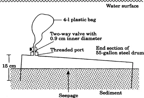
Figure 1 Lee-type manual seepage meter [Lee, 1977].
Studies involving seepage meters have reached the following general conclusions: (1) many seepage meters are needed because of the natural spatial and temporal variability of seepage rates [Shaw and Prepas, 1990a,b]; (2) the resistance of the tube [Fellows and Brezonik, 1980] and bag [Shaw and Prepas, 1989; Belanger and Montgomery, 1992] should be minimized to prevent artifacts; (3) use of a cover for the collection bag may reduce the effects of surface water movements due to waves, currents or streamflow activities [Libelo and MacIntyre, 1994]; and (4) caution should be applied when operating near the seepage meter detection limit [Cable et al., 1997].
The influence on seepage measurements of frictional resistance in the tube connecting the drum to the collector bag produces inaccurate seepage rates. These inaccuracies can be minimized by using larger (0.9 cm ID) diameter plastic tubes [Fellows and Brezonik, 1980]. Shaw and Prepas [1989] found an anomalous short-term influx of water occurred when water was entering the collection bags after the bags were attached to seepage meters. They also showed that pre-filling the bags with a measured amount of water (about 1000 mL) reduced this measurement artifact substantially. The effect of surface water flow over the seepage meter and collection bag was discussed by Libelo and MacIntyre [1994], because it altered the hydraulic head within the meter augmenting seepage flow. Surface-water flow due to waves, currents, or streamflow reduces the hydraulic head in the meter resulting in an anomalously high value of measured seepage flux. Covering the collection bag with a bucket to isolate it from overlying surface water flow significantly reduces this error.
Although the application of manual type seepage meters has had some problems as menti...
Table of contents
- Cover image
- Title page
- Table of Contents
- Copyright
- PREFACE
- Chapter 1: Assessment methodologies for submarine groundwater discharge
- Chapter 2: Radon Tracing of Submarine Groundwater Discharge in Coastal Environments
- Chapter 3: The chemical characteristics of submarine groundwater seepage in Toyama Bay, Central Japan
- Chapter 4: Prospects of engineering applications of submarine-groundwater-discharge research in Japan
- Chapter 5: Evaluation of seawater intrusion accompanying the coastal coalmine excavation in the Joban coalfield area, Japan
- Chapter 6: Natural tracing in karst aquifers
- Chapter 7: Abundance and Viability of Subsurface Microbial Communities in Sedimentary and Igneous Rock Aquifers
- Chapter 8: Stable isotopic compositions of bacterial light hydrocarbons in marginal marine sediments
- Chapter 9: Submarine hydrothermal activity in coastal zones
- Chapter 10: High Permeability of Young Oceanic Crust Constrained by Thermal and Pressure Observations
- INDEX OF AUTHORS
- SUBJECT INDEX
Frequently asked questions
Yes, you can cancel anytime from the Subscription tab in your account settings on the Perlego website. Your subscription will stay active until the end of your current billing period. Learn how to cancel your subscription
No, books cannot be downloaded as external files, such as PDFs, for use outside of Perlego. However, you can download books within the Perlego app for offline reading on mobile or tablet. Learn how to download books offline
Perlego offers two plans: Essential and Complete
- Essential is ideal for learners and professionals who enjoy exploring a wide range of subjects. Access the Essential Library with 800,000+ trusted titles and best-sellers across business, personal growth, and the humanities. Includes unlimited reading time and Standard Read Aloud voice.
- Complete: Perfect for advanced learners and researchers needing full, unrestricted access. Unlock 1.5M+ books across hundreds of subjects, including academic and specialized titles. The Complete Plan also includes advanced features like Premium Read Aloud and Research Assistant.
We are an online textbook subscription service, where you can get access to an entire online library for less than the price of a single book per month. With over 1.5 million books across 990+ topics, we’ve got you covered! Learn about our mission
Look out for the read-aloud symbol on your next book to see if you can listen to it. The read-aloud tool reads text aloud for you, highlighting the text as it is being read. You can pause it, speed it up and slow it down. Learn more about Read Aloud
Yes! You can use the Perlego app on both iOS and Android devices to read anytime, anywhere — even offline. Perfect for commutes or when you’re on the go.
Please note we cannot support devices running on iOS 13 and Android 7 or earlier. Learn more about using the app
Please note we cannot support devices running on iOS 13 and Android 7 or earlier. Learn more about using the app
Yes, you can access Land and Marine Hydrogeology by M. Taniguchi,K. Wang,T. Gamo in PDF and/or ePUB format, as well as other popular books in Physical Sciences & Geography. We have over 1.5 million books available in our catalogue for you to explore.