![]()
CHAPTER 1
HOW NOWHERE BECAME SOMEWHERE
THE AREA AROUND the Nevada Test and Training Range (NTTR) and the Nevada National Security Site (N2S2) is about the closest approximation to the idea of “the middle of nowhere” that can be found anywhere in the contiguous United States. One can easily drive for an hour with but scant evidence of human habitation and for a half hour on Highway 375 without passing another car.
For centuries, what is now southern Nevada, and indeed most of the state, remained largely empty because of its harsh climate and widespread lack of water. Only small numbers of Paiute and Shoshone lived here when Anglo Americans first passed through what are now the NTTR and N2S2 in the nineteenth century, and they lived only in the relatively few fertile valleys. Early in that century, westward-bound wagon trains generally avoided southern Nevada. Later, inspired by the Comstock silver boom in northern Nevada, prospectors established a scattering of mainly disappointing mines.
The abandoned homes of nineteenth century ranchers and prospectors can still be found in remote corners of the Nevada Test Site and the adjacent Nellis Range. DOE
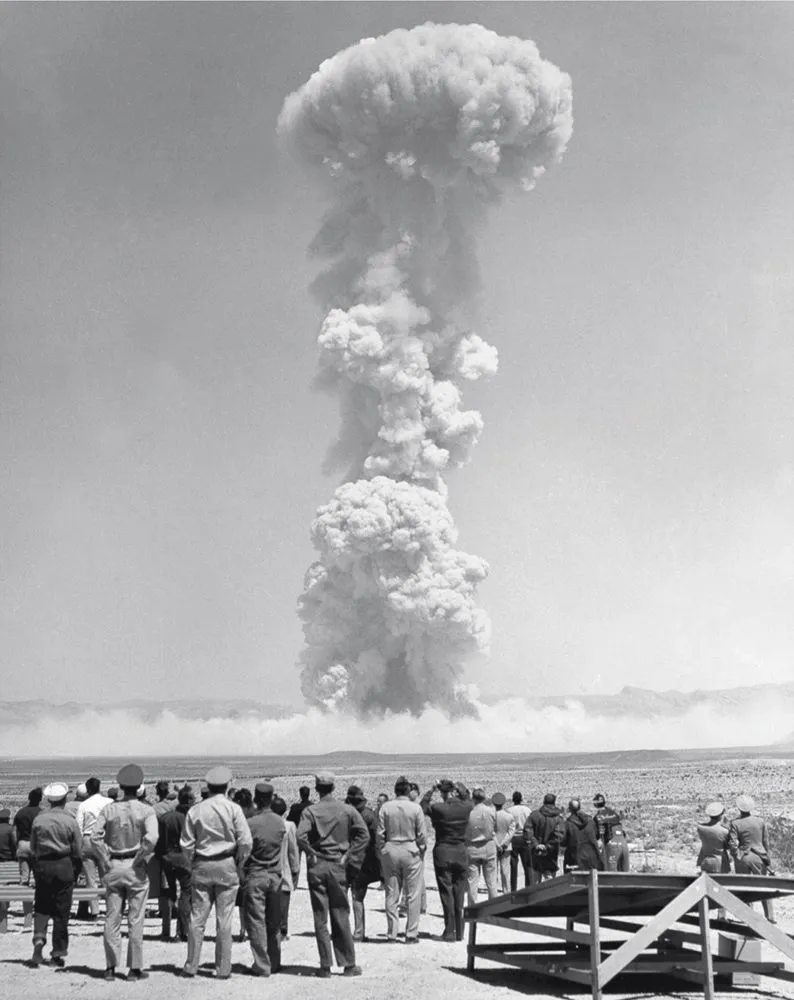
Military personnel casually observe a 22-kiloton blast at Frenchman Flat in Area 5 of the Nevada Test Site on April 15, 1955. NNSA/NSO
By the twentieth century, there were a few ranches and a few small towns, such as Tonopah, Goldfield, and Rhyolite. To the south, Las Vegas was incorporated in 1911. While Las Vegas flourished as a railroad town and later as a gaming mecca, places like Rhyolite withered into ghost towns as the mines became unsustainable.
In October 1940, President Franklin Roosevelt signed off on the idea of turning more than three million acres of government-owned land in the “middle of nowhere” north of Las Vegas over to the US Army Air Corps as the Las Vegas Bombing and Gunnery Range. The Las Vegas Army Airfield (now Nellis AFB) was established on the north side of Las Vegas in 1941 to manage operations over the range, which included the Army Gunnery School, started in 1942.
Additional auxiliary fields managed by the main base were set up at places such as Indian Springs, near Las Vegas on the southwest corner of the range, as well as at Pahute Mesa, Groom Lake, and near Tonopah. Las Vegas AAF was renamed as Nellis AFB in 1950, while Indian Springs became Creech AFB in 2005 and is now well known as the home to MQ-1 Predator and MQ-9 Reaper unmanned aerial vehicle operations. Tonopah is active, but mainly in secrecy, while Groom Lake officially does not exist.
The 24-kiloton “Nancy” test, seen here, was conducted on March 24, 1953, as part of Operation Upshot-Knothole. NNSA/NSO
Dr. Alvin Graves, scientific advisor for the nuclear tests at the Nevada Test Site, points out a location near Beatty, Nevada, for support director Seth Woodruff and test manager James Reeves in March 1955 during Operation Teapot. Graves served at Los Alamos during the Manhattan Project. NNSA/NSO
After World War II, another slice of the huge range became famous for another purpose. Even as the future Nellis AFB was finding its place in the postwar air force, the United States was assembling a growing arsenal of nuclear weapons. Managing this stockpile was the responsibility not only of the armed forces, but also of the new Atomic Energy Commission (AEC), which was set up in 1946 to oversee American nuclear programs.
These weapons required testing, which naturally required a place for the tests. The first test had occurred in New Mexico in July 1945, but the early postwar tests took place at remote islands in the Pacific Ocean for security reasons. However, the complex logistics required for the Pacific tests led the AEC and the services to move the testing to the contiguous United States. President Harry Truman initially disagreed with the AEC and supported a continuation of the Pacific tests, but against the backdrop of the Korean War, he reconsidered, and in October 1950, he gave the green light.
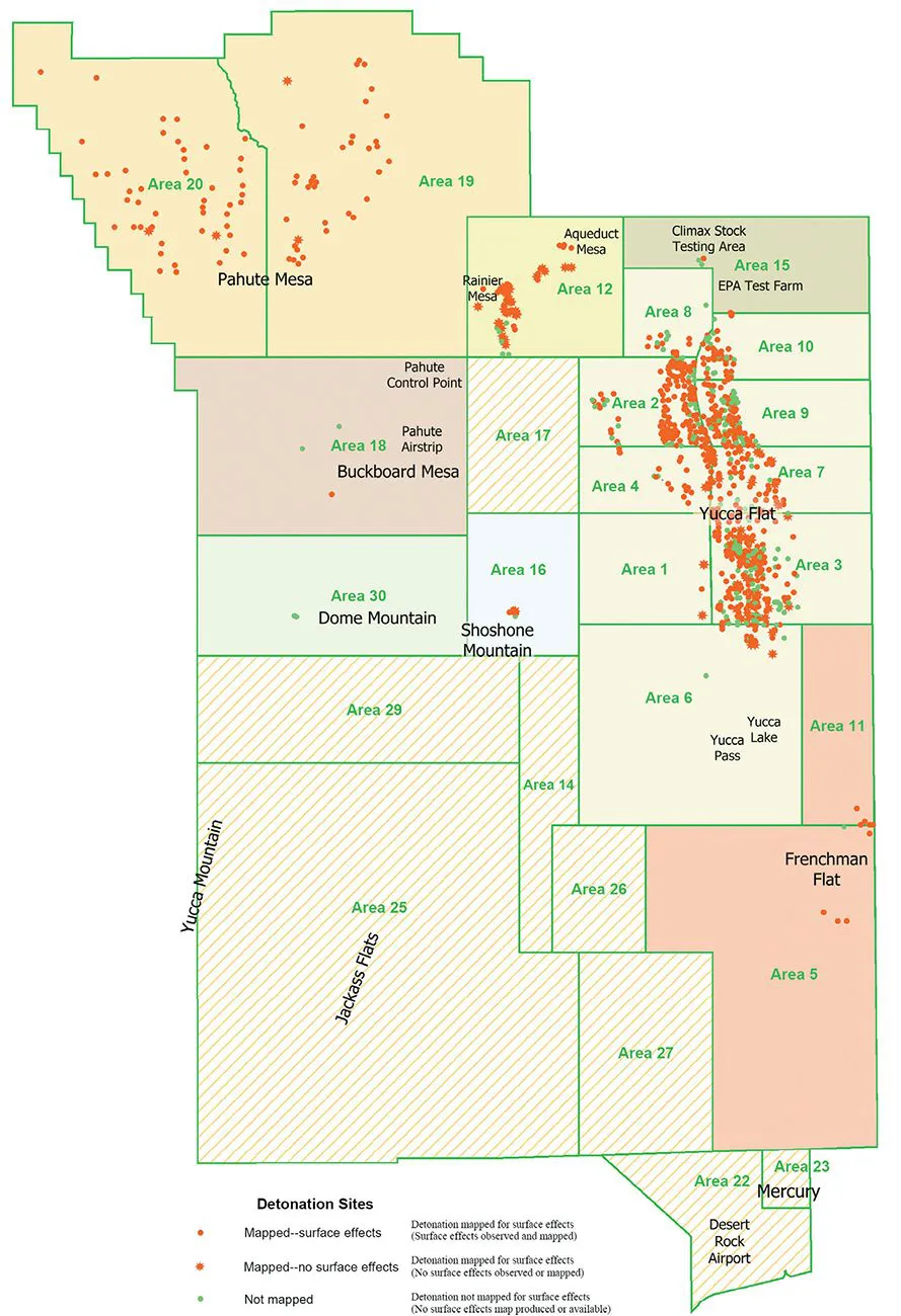
This map shows the numbered areas of the Nevada Test Site, as well as the specific locations of underground nuclear tests conducted here through 1992. Most above-ground nuclear tests took place in Areas 1 through 8, which include Yucca Flat, and in Area 25, which includes Jackass Flats. The segment of Nellis Range air space known as Dreamland (encompassing Area 51), overlays the northeast edge of the Nevada Test Site, including the eastern edges of Areas 15 and 10. The Pahute Airstrip in Area 18 remains active. This map was prepared in 2003 by Dennis Grasso as part of the Geologic Effects of Underground Nuclear Testing project. USGS
In 1947, the search for a site and the development of nuclear weapons doctrine was undertaken under the Armed Forces Special Weapons Project (AFSWP, pronounced AF-SWAP), codenamed Project Nutmeg.
According to Barton Hacker in his book Elements of Controversy, AFSWP Search Committee Director Howard Hutchinson was asked to assess the “physical feasibility [and the] how, when, and where” of conducting nuclear weapons tests in the continental United States without, and as Hutchinson himself put it, radioactive fallout causing “physical or economic detriment to the population.” Hutchinson concluded that “properly engineered sites, under proper meteorological conditions [such tests would] result in no harm to population, economy or industry.”
Remote locations across the desert Southwest were considered, but so too were areas along the coasts of Maine, Maryland, Delaware, Virginia, and the Carolinas. The most ideal of these was thought to be the area north of Cape Fear, an arguably appropriate name for a nuclear test site.
By this time, the Nutmeg team had essentially picked the best possible continental site. They had come to the Las Vegas Bombing and Gunnery Range, experienced its vast emptiness, and realized that this “middle of nowhere” would be a good place for the “somewhere” of American atmospheric nuclear testing. Title to the 1,360-square-mile slice of the bombing range was formally transferred from the US Air Force to the AEC, though the air force controlled the air space and dropped many of the early nuclear weapons.
The Atomic Energy Commission “company town” of Mercury, Nevada, was founded in 1950 within the Nevada Test Site as the spartan facility known as Base Camp Mercury. Within a year, a $6.7-million construction project was transforming it into the sprawling city seen here. NNSA/NSO
Security guards at the gateway to the Nevada Test Site south of Mercury stand ready to check passes of incoming and outgoing personnel in 1953. Security is still tight here, and tighter still at the classified US Air Force locations that officially do not exist. NNSA/NSO
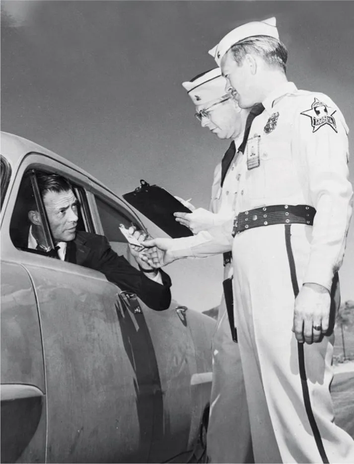
Guards Milton Miller and John Metcalf inspect the pass of a nervous Frank Waters at the entrance to the Nevada Test Site in 1953 (when it was still called the Nevada Proving Grounds). Waters worked for the Joint AEC-DOD Test Information Office. Miller and Metcalf were employed by Federal Services, Inc., a contractor that supplied security services. NNSA/NSO
Initially known as the Nevada Proving Grounds, and later as the Nevada Test Site (NTS), it was established due north of Indian Springs on January 11, 1951. The first nuclear test here took place as part of Operation Ranger just sixteen days later.
Initial uneasiness about the tests in Las Vegas gradually dissipated as the AEC undertook a massive construction program, pumping many federal dollars into a local economy that had yet to reinvent itself as a destination resort. The building boom included the new “company town” of Mercury, Nevada, 65 miles northwest of Las Vegas, which housed AEC staff. It eventually had a population of around 10,000. Indeed, Las Vegas even embraced the testing, with people gathering on rooftops for parties organized around the viewing of mushroom clouds rising from the distant test site.
During the years of extensive atmospheric testing at the NTS, little was done to conceal the program from the general public. Indeed, with mushroom clouds visible from Las Vegas, little could be done. However, many aspects of the program remained under wraps, many of them remaining secret through the end of the century and beyond.
One intriguing clandestine aspect of NTS operations during the atmospheric testing era involved the Lookout Mountain Laboratory, which remained classified for over a quarter century after it closed and is hardly spoken of even today. Indeed, Lookout Mountain barely registers on the radar of the Area 51 conspiracy theorists who passionately seek out shadowy government and contractor entities.
Amazingly, the Lookout Mountain Laboratory existed right under the noses of the national media in the Hollywood Hills! The laboratory was actually a state of the art motion picture studio that was secretly established in 1947 in a 100,000-square-foot building on Wonderland Avenue in Los Angeles. The facility was originally built in 1941 as an air defense radar coordination center. From 1947 to 1969 it operated secretly as the Lookout Mountain AFS, providing production services for classified motion pictures and still photography for the Department of Defense (DOD) and the AEC at the NTS, at the nuclear and missile test sites in the Pacif...