A comprehensive analysis of the various terrestrial natural landscapes and habitats within Japan, and the efforts to sustain and conserve them and sustain landscape services.
In 2011, Conservation International designated the Japanese islands collectively as one of the world's biodiversity hotspots. They are rich in biodiversity, but also densely populated and so human impacts have led to many species being classed as endangered though few have become extinct during recent decades. Sugimura evaluates the effects of landscape changes, government policies and economy on the forest ecosystems and services of Japan. He then contemplates how a rich variety of wildlife species have been able to survive, albeit in limited numbers, despite the rapid expansion of Japanese economic activities in the 20th century. In addition, there appear to be correlations between uniqueness of biodiversity, types of landscape use and the attitudes of local communities towards natural landscapes.
A vital introduction for international environmentalists, geographers and environmental scientists looking to understand Japan's unique ecosystems and their experiences with human activities.
Trusted by 375,005 students
Access to over 1.5 million titles for a fair monthly price.
1Terrestrial biodiversity and landscape use across the country
A brief overview
1.1 Geographical landscapes of Japan
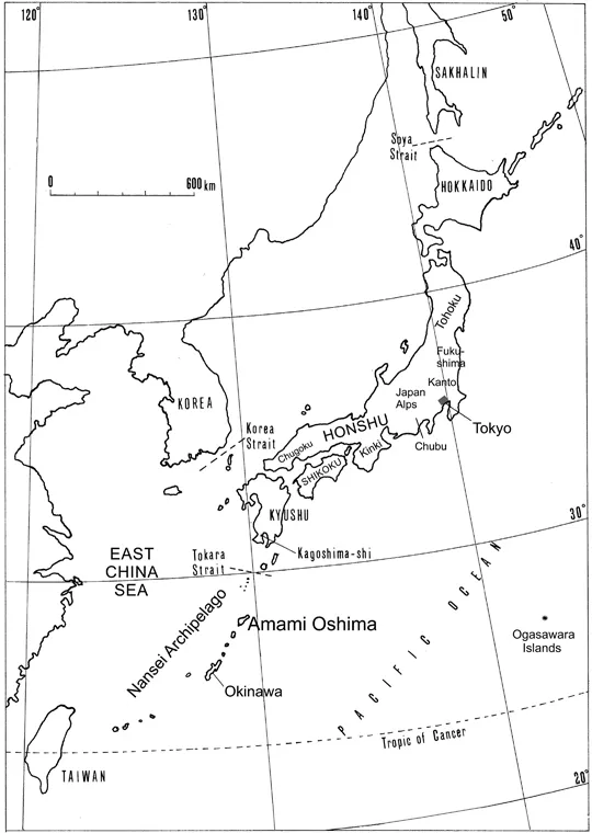
The land mass of Japan is about 378 thousand km2, consisting of four main islands: Hokkaido located in the north, Honshu in the centre, Shikoku and Kyushu in the southwest (Figure 1.1). Off the south shores of Kyushu expands a long chain of islands, the Nansei Archipelago, extending to the west of Taiwan. The archipelago of islands extends in a northeast-southwest direction, with approximately equal length of Honshu. The country is subdivided into 47 prefectures. Japanese people often feel a sense of belonging in a specific prefecture or region, occasionally an island, as a regional unit. The population was the 11th largest in the world in 2019, in contrast to total land mass, which ranks 62nd (United Nations, 2019), indicating high population density.
Figure 1.1 Geography of Japan: Names of key regions and locations described in the following chapters.
Honshu is administratively divided into five regions, namely Tohoku (northernmost part), Kanto (east-central, south of Tohoku), Chubu (central, west of Kanto), Kinki (west-central) and Chugoku (westernmost Honshu). Mountain ranges with high altitudes and steep slopes in a row demarcate the boundaries clearly between Tohoku, Kanto and Chubu regions. Chubu has high mountain ranges with some 3000 m class mountains. Its southern part of the border with Kinki is not very clear, located in the second-largest plain in the country. Fukushima Prefecture, which unfortunately became world-famous after the nuclear power plant accident, is located towards the southernmost border in the Tohoku region and just north of Kanto. The national government occasionally places regional administrative offices according to these geographical divisions to implement national policies into practice. In the case of environmental policies, an example is the Forestry Agency that retains a regional office in Kyushu to manage the national forests and subsidises many projects operated by local governments as well as those in collaboration with private woodlands across the regions of Kyushu and Okinawa. Amami Oshima, which is discussed extensively in the following two chapters, is one of the largest islands of the Nansei Archipelago, belonging to the Kagoshima Prefecture, which is located southernmost in Kyushu, though this region resembles Okinawa geographically, historically and culturally. The Ministry of the Environment, in the Okinawa regional office, declared the importance of the Nansei Archipelago for crucial biodiversity conservation in addition to the main Kyushu region.
Population size, density and distribution have large geographic variations. For example, Hokkaido has the lowest density of 64 people/km2, Tohoku ranks the second lowest of 134 and Kanto has the highest density of 1326 (Soˉmushoˉ Toˉkeikyoku, 2017). The Kanto Plain, the largest plain in the country, forms a metropolitan area with three neighbouring prefectures, including Tokyo, where the population is about 30 million people, about a quarter of the population of Japan. The second-largest metropolitan area, so-called Keihanshin, is in the western part of Kinki region, where half of the population of the Tokyo metro area lives in cities that have relatively low mountains nearby. Mountainous areas are popular sites for recreation, where people enjoy a good view from the top. The most remarkable difference between the two areas is that a few mountain peaks are far more crowded with visitors in the Tokyo area than in Keihanshin. The use is more dispersed in the latter because there are more mountains nearby. The Pacific Belt Zone has a high concentration of urban populations, extending from Tokyo to the northern part of Kyushu. It covers coastal areas of Pacific Ocean in Kanto and Chubu, the central Kinki and an inland sea (Setonaikai) between Chugoku and Shikoku regions. Excluding Hokkaido and Tohoku regions, the population density of a prefecture is, generally speaking, inversely correlated with the percentage of forested area. In the Kanto region including Tokyo, where population density is the highest at 1326/km2, forests cover only 43% of the land mass. In contrast, in the three prefectures west of Tokyo, the forests cover is vast at 80% of the land mass with a small population density of 173/km2.
Natural vegetation and ecosystems are immensely diverse from Hokkaido to the Nansei Archipelago due to the long length of Japan, from the most northern point of 45 degrees to the most southern point of 20 degrees North latitudes. The natural vegetation of Hokkaido represents either cool-temperate or subarctic climates in low-altitude plains, where deciduous broadleaf trees and conifer trees dominate. Hokkaido is cold in winter, and the average temperature in January in Sapporo (43 degrees N latitude), the largest city, is minus 3.6 degree Celsius. The wildlife fauna of Hokkaido is more similar to that of the Eurasian continent to the west than to the south (Honshu) as indicated below. Additionally, this region underwent a radical change in the use of natural landscapes, when the Japanese occupation drove out the indigenous people, the Ainu, during the last half of the 19th century. Consequently, from the traditional land use of natural resources by the Ainu, in the present day, much of the land use is now largely agricultural, and hence Hokkaido has lost much of its traditional use of landscapes, although its reminiscence can still be seen in the Tohoku region. Typically, the climate of the Tohoku region lends itself to deciduous broadleaf forests. These characteristic broadleaf forests vegetation zone gradually moves towards areas of high altitude from southern parts of Tohoku to southern Kyushu, where the zone near the mountain apex, such as that in Yakushima Island, can be above 1500 m high and equivalent to the Tohoku region (Kankyoˉ-shoˉ, 2010). Zones of lower elevations of the southern regions are often dominated by evergreen oaks (Quercus spp.), although formally, the natural vegetation would have been broadleaf evergreen forests. This is due to extensive replanting of commercial timber trees, such as sugi cedar Cryptomeria japonica and hinoki cypress Chamaecyparis obtusa, wherever soil conditions were deemed favourable in this zone. In the Chubu region, the apparent transition from the evergreen broadleaf forest to deciduous broadleaf forest occurs at altitudes of 500–600 m (Otsuka and Ozeki, 2015). In contrast, the Nansei Archipelago has canopy tree species not found in the mainlands, such as Schima wallichii and Distylium racemosum, suited to the subtropical to tropical climates. Epiphytes are common, and hence the forest interior looks similar to montane forests in Java (Chapter 6). Mangrove forests grow in coastal swamps, which are not found in mainland Kyushu.
1.2 Species richness
Japan is rich in biodiversity and has a broad range of ecological niches relative to its land mass. Four major factors contribute to species richness:
Wide range of latitude from Hokkaido to Okinawa
The elevation difference from sea level to mountain summits 2000–3000 m high
The connections of Japanese islands to the Asian continent during the last glacial periods by land bridges
Combinations of natural and anthropogenic disturbances
Japan extends from Cape Soya in Hokkaido, at 45 degrees 31 minutes N Latitude, to Yonaguni Island as the southwestern tip of the country, which is located east of Taiwan at 24 degrees and 27 minutes N Latitude. Two opposing ocean currents, a cold stream (Oyashio) and a warm stream (Kuroshio) flowing from the north and south, respectively, amplify the climatic differences. The Oyashio Cold Current flows northeast of Hokkaido to the south along the Pacific coast, which is strong in winter and cools Hokkaido down further contributing to the relatively cooler temperate conditions in the north. The Kuroshio Warm Current flows northward off the Pacific coast, and its strong summer current makes the Japanese summers significantly hotter and tropical. Thus, the climate differences between the north and the south are more distinctive than that of countries in Western Europe or the west coast of North America with similar land mass. The average temperature ranges from minus 3.7 degree Celsius in January and 17.3 in August in Nemuro, a city in the easternmost part of Hokkaido, while it is 18.4 degree Celsius in January and 28.5 degree Celsius in August on Yonaguni Island as the latest three-decade average (Kishoˉ-choˉ, 2019).
The vast differences in climatic conditions are reflected in the differences observed in the dominant canopy tree species between Hokkaido and the Nansei Archipelago. Okitsu (2003) reported that a boreal forest had conifers such as Picea jezoensis, Picea glehnii and Abies sachalinensis as well as deciduous L...
Table of contents
Cover
Half Title
Series Page
Title Page
Copyright Page
Contents
List of tables
List of figures
Preface
Acknowledgements
Introduction: aims and scopes
1 Terrestrial biodiversity and landscape use across the country
2 Amami Oshima
3 Amami Oshima (2)
4 Forest utilisation in Fukushima before and after the 2011 power plant accident
5 Forests and Satoyama landscapes in the suburb of a metropolitan area
6 Regional comparison and summary discussion
References
Index
Frequently asked questions
Yes, you can cancel anytime from the Subscription tab in your account settings on the Perlego website. Your subscription will stay active until the end of your current billing period. Learn how to cancel your subscription
No, books cannot be downloaded as external files, such as PDFs, for use outside of Perlego. However, you can download books within the Perlego app for offline reading on mobile or tablet. Learn how to download books offline
Perlego offers two plans: Essential and Complete
Essential is ideal for learners and professionals who enjoy exploring a wide range of subjects. Access the Essential Library with 800,000+ trusted titles and best-sellers across business, personal growth, and the humanities. Includes unlimited reading time and Standard Read Aloud voice.
Complete: Perfect for advanced learners and researchers needing full, unrestricted access. Unlock 1.5M+ books across hundreds of subjects, including academic and specialized titles. The Complete Plan also includes advanced features like Premium Read Aloud and Research Assistant.
Both plans are available with monthly, semester, or annual billing cycles.
We are an online textbook subscription service, where you can get access to an entire online library for less than the price of a single book per month. With over 1.5 million books across 990+ topics, we’ve got you covered! Learn about our mission
Look out for the read-aloud symbol on your next book to see if you can listen to it. The read-aloud tool reads text aloud for you, highlighting the text as it is being read. You can pause it, speed it up and slow it down. Learn more about Read Aloud
Yes! You can use the Perlego app on both iOS and Android devices to read anytime, anywhere — even offline. Perfect for commutes or when you’re on the go. Please note we cannot support devices running on iOS 13 and Android 7 or earlier. Learn more about using the app
Yes, you can access Wildlife, Landscape Use and Society by Ken Sugimura in PDF and/or ePUB format, as well as other popular books in Biological Sciences & Environmental Science. We have over 1.5 million books available in our catalogue for you to explore.