- 192 pages
- English
- ePUB (mobile friendly)
- Available on iOS & Android
eBook - ePub
About this book
The East End is one of the most famous parts of London and it has had its own distinctive identity since the district was first settled in medieval times. It is best known for extremes of poverty and deprivation, for strong political and social movements, and for the extraordinary mix of immigrants who have shaped its history. Jonathan Oatess handbook is the ideal guide to its complex, rich and varied story and it is an essential source for anyone who wants to find out about an East End ancestor or carry out their own research into the area.He outlines in vivid detail the development of the neighbourhoods that constitute the East End. In a series of information-filled chapters, he explores East End industries and employment the docks, warehouses, factories, markets and shops. He looks at its historic poverty and describes how it gained a reputation for criminality, partly because of notorious criminals like Jack the Ripper and the Krays. This dark side to the history contrasts with the liveliness of the East End entertainments and the strong social bonds of the immigrants who made their home there Huguenots, Jews, Bangladeshis and many others.Throughout the book details are given of the records that researchers can consult in order to delve into the history for themselves online sites, archives, libraries, books and museums.
Trusted by 375,005 students
Access to over 1.5 million titles for a fair monthly price.
Study more efficiently using our study tools.
Information
Chapter 1
WHAT IS THE EAST END?
We need to briefly examine the East End’s history in order to inform ourselves of the background to the material that is to be discussed in later chapters. As has already been made clear, it was not a homogeneous entity, but a number of distinct settlements which grew over time.
Origins and Medieval East End
Although there were some Roman settlements to the east of the City of London, the first fixed settlements of any size emerged after the Romans had left. The largest district was Stepney, which stretched from the eastern fringes of the City to the River Lea and from Mile End in the north to the Thames in the south, and takes its name from Stebunheath or Stebba’s landing. Central was St Dunstan’s church. This was the ancient manor, held by the bishop of London, a Saxon settlement, which was recorded in some detail in the Domesday Book of 1086. The population then stood at about 900 people, who worked on the land – arable, pasture, meadowland and woodland. There were also mills there. Hoxton was another East End Domesday manor.
One of the hamlets of the parish of Stepney was Bethnal Green, possibly of Saxon origin as Blithehale. Another was Whitechapel, named because there was a chapel there that was white. This began its existence as a medieval suburb of the City of London, on the main road to Essex.
To the east of Spitalfields, a mile along the main road, was, appropriately enough, Mile End. In this period it was dominated by the parish church of St Dunstan, surrounded by several large houses of the gentry. There were smaller clusters of housing around the manorial common land, where in 1381 Wat Tyler’s rebels massed before marching on London. A few days later there was the fatal encounter between Richard II and the peasant rebel, in which the Lord Mayor killed the latter and the young King then effectively ended the rebellion.
Bow (once called Stratford Bow) and Bromley (not to be confused with the place of the same name to the south of Lewisham and in the county of Kent until 1965) were to the east, both with crossings of the Lea as the road ran from London to Colchester. Bromley grew up around a medieval nunnery. The first stone bridge in England was built here in the early twelfth century because Henry I’s queen nearly drowned when crossing the ford. To the west of these was Bethnal Green. To the south were a number of hamlets on the north side of the Thames: Wapping, Ratcliff, Shadwell, Limehouse and Poplar, linked by the road named the High Way (so called because it was on higher ground than the riverside marshes).
Wapping, named after the Saxon Waeppa, was established as a settlement in the fourteenth century when the marshland had been reclaimed and water defences were built. Wharves then spread along the waterfront. Buildings had sprung up from the City to this district by the fifteenth century.
Limehouse was another small medieval Thameside settlement, which is known to have existed since the fourteenth century, though was initially known as Limekiln. This was naturally because of the lime kilns here when chalk was brought from Kent to be used in the London building business.
In the Middle Ages there were two major religious foundations in this part of London; the Cistercian priory of St Mary Graces, near the Tower of London, and St Mary Spital (from which the district Spitalfields takes its name). There was also the Royal Foundation of St Katharine’s, also known as the Priory of St Leonard’s in Bromley.
Hoxton and Haggerston were both mentioned in the Domesday Book and made up part of the manor of Shoreditch. The latter was at the junction of two old Roman roads but was not mentioned as an entity until 1148. As with neighbouring districts, there was a religious foundation, the Augustinian Priory of Holywell, which was also the major landowner here until the dissolution in 1539.
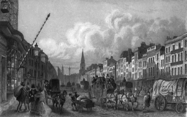
High Street, Whitechapel (collection of Lindsay Siviter).
All these places were quite distinct from another, with a great deal of open land between them – unlike the built-up area that was the cities of Westminster and London to the west. In the twelfth century Hoxton was described thus: ‘the fields for pasture and open meadows, very pleasant, into which the river waters do flow and mills are tarried about with a delightful noise. Next lieth a great forest, in which are woody places for game’.
Early Modern East End
This period saw what was once a collection of hamlets surrounded by fields and pasture begin to be transformed. The hamlets became small towns and London began to spread eastwards. Yet they were still desirable places to live in. The medieval hamlets expanded considerably in these centuries. By about 1700 there were about 3,000 houses in Whitechapel, including many Jewish immigrants. Limehouse’s population rose from about 2,000 in 1610 to 7,000 in 1710. Change, however, was variable as population growth in these districts was quite uneven.
These places were ruled by parishes and overseen, as was the whole of London (excepting the City) and Middlesex, by the Middlesex Quarter Sessions, a body of justices of the peace who dealt with disputes between the parishes and administrative matters as well as law and order. Growth occurred as the hamlets expanded in size. Stepney was no longer the principal body of local government as it had been in the Middle Ages when it had been the manor. Its size meant that it was too unwieldy a unit for administrative purposes. Instead its constituent parts formed their own self-governing parishes in the seventeenth and eighteenth centuries. These were Shadwell (1669), St George’s in the East (1727), Spitalfields (1729), Bow and Limehouse (1730) and Bethnal Green (1743).
One reason for this growth was that industries and trade grew up along the Thames, as part of a national expansion of overseas commerce. Coal from Newcastle and goods from elsewhere in Britain were transported up the Thames. Malt and grain were shipped down the River Lea from Hertfordshire. Mills and bakeries sprang up at Bow, though some had existed there since the eleventh century.
There were still many farms in the district even by the eighteenth century. In Bromley there were 60 acres of market gardens as well as arable and pasture land. In Bethnal Green there was even more land employed for agriculture: 190 acres of arable land, 160 acres of grassland and 140 acres of market gardens. Some of this produce was sold and eaten locally and the rest was sold in the London markets. There were also brickfields in Bethnal Green providing material for building houses locally and in London.
Some parts were quite prosperous, such as Mile End, which until the early nineteenth century was a select place for merchants and gentry. Spitalfields flourished as a centre of the silk trade, which, from the seventeenth century, was dominated by the Huguenots, strengthening an industry which was already in existence. It was a fashionable address and was convenient for businessmen working in the City. Other merchants made their homes here, including German sugar refiners in Whitechapel and Baltic timber merchants in St George’s parish. Handsome Georgian houses illustrated the prosperity of many residents in this district. Bethnal Green was once home to courtiers resident in mansions. However, Poplar was never attractive for the well to do. There were also theatres, new churches and from 1750, the London Hospital.
Shoreditch had a central role to play in London’s theatrical history. James Burbage founded the first theatre in England here. It was there from 1576 to 1592 before moving to Southwark where it was re-erected and named The Globe. There was another local theatre, in 1577, titled The Curtain, owned by one Henry Lanman in 1582. It existed here until 1625. Many actors lived in the vicinity and several were buried at the parish church.
The eighteenth century saw Britain’s overseas trade grow spectacularly and London became a central market for luxury goods. Because of this, shipyards and docks were established here by the major trading companies, such as the East India Company. Ropeworks and other maritime industries emerged along the waterfronts to cater to the shipping that docked on the Thames. Cable Street was so called because of the many rope yards in the St George’s district.
There was further industrial expansion in the following century. Enclosed docks made the place less confused. Secure storage was created to house bulky commodities such as sugar, tea and tobacco. Industry spread along the Lea and giant breweries at Spitalfields and Mile End were major employers of local labour. There were many small businesses, too, mostly in the clothing trade which had replaced the silk industry of the previous centuries. Much of this work was done in the home and employed many of the poor Jewish immigrants from Eastern Europe who arrived in the later nineteenth century, especially to Whitechapel, Spitalfields and Bethnal Green.
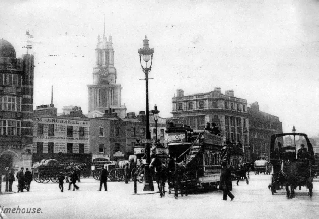
Limehouse (collection of John Coulter).
Many skilled artisans and craftsmen lived in St George’s, alongside market gardeners scattered among patches of housing and common land. Maritime suppliers dominated Wapping, as John Stow remarked about Wapping High Street with ‘alleys of small tenements and cottages, inhabited by sailors’ victuallers’. There were also homes of the prosperous shipbuilders here, at least until the eighteenth century.
Shadwell and Ratcliff, two of the hitherto tiny riverside communities, grew considerably in this period. By 1669, Shadwell had about 8,000 residents, many of whom were mariners. Ratcliff had about 3,500 people in this century. Most were employed in various industries such as glassmaking and others more obviously related to maritime matters.
Jews and the Irish began to settle in this district. One of Cromwell’s few pieces of liberal legislation was to allow the former to reside in England again (having been expelled from the country in the thirteenth century). A Jewish cemetery was established in Mile End in 1657. Danes and Swedes lived in St George’s in the East by the eighteenth century.
Poverty existed, though nothing on the scale that was to be reached in the nineteenth century. John Stow, in the sixteenth century, wrote thus of Mile End, ‘this common field, being sometime the beauty of the City on that part is so encroached upon by building of filthy cottages’. Of Whitechapel High Street he wrote that it was ‘no small blemish on so famous a city’. John Wesley wrote in 1771, ‘I began visiting those of our society who lived in Bethnal Green. Many of those I found in such poverty as few can conceive without seeing it’. Schools, almshouses and other institutions began to be erected in these parishes for the less well off. One of the first Nonconformist schools in the country was established in Hoxton in the later seventeenth century. Two almshouses were built in Bromley by 1613. In 1792 a Universal Medical Institute was in existence in St George’s to provide free medicine and medical advice, being funded by private donations.
The reverberations of national history were also felt here. In 1556, 13 heretics were burnt at Bow as part of Queen Mary’s campaign against Protestantism. Fortifications were built at Shadwell and Whitechapel to ward off any attack on London as Parliament defied Charles I when the civil war began in 1642.
The Nineteenth Century
It was in this century that the term ‘the East End’ was first coined. It was increasingly viewed by outsiders, often prosperous Londoners in the West End of London, as a centre of barbarism, poverty and vice. The hideous murders committed there in 1888 were held up as proof of this, but equally well-heeled reformers pointed out that this was a sign that reform – in health, housing and education – was vital. All agreed, though, that the East End was desperately poor. This was in contrast to the situation in previous centuries.
Social reformer Henry Mayhew wrote of Whitechapel, ‘The poverty of these workers compels them to lodge wherever the rent of the rooms is lowest’. Later in the century Charles Booth referred to ‘the eldorado of the East, a gathering together of poor fortune seekers; its streets full of buying and selling, the poor live on the poor’. According to him, in 1889, 45 per cent of the population lived below the subsistence level. The rector of Limehouse wrote in 1861, ‘the parishioners are for the most part poor … There’s an increase of low lodging houses for sailors ... and the removal of the more respectable families to other districts’. Apparently Shoreditch ‘ranks second among eastern area boroughs in the percentage of persons living in poverty’ because of the overcrowding and poverty in Hoxton.
By this time, the distinct villages that had made up the East End up to the eighteenth century had disappeared. In 1801 population had been about 142,000 and a century later it was almost 600,000. Furthermore, Shoreditch’s population rose from 35,000 in 1801 to 129,000 in 1861, though it had undergone a slight decline to 117,706 in 1901. The district was a continuous urban sprawl of small streets, interspaced by roads, railways and canals (the Limehouse Canal, opened in 1770, was London’s first, and locally it was followed by the Regent’s Canal in 1820), as well as factories, gasworks and breweries. Gone were the merchants of the past, and the population was predominantly working class.
However, in the north was a significant open space, created by government in 1845: Victoria Park. This was London’s first new park of the century and consisted of nearly 300 acres. Initially there were hopes that this would be part of a middle-class suburb.
The docks and industry were stimulated by the better transport links, such as the London and Blackwall Railway in 1840 and the North London Railway in 1850. The East Counties Railway ran though the district as far as Shoreditch by 1840 but there was no station locally until the 1870s. There were also new roads and canals linking the docks to their markets and sources of raw materials.
Some industries which had previously flourished were now in decline. Silk weaving was in depression, with foreign competition leading to factories moving elsewhere. What remained of the clothing trade was small-scale workshops reliant on ‘sweated labour’. The houses of the wealthy were sold as their owners moved out and were subdivided for poorer residents. There was also some decline in the docks, as the St Katharine Docks were deemed too small for the modern and larger shipping so the company relocated most of its business to the new and larger Victoria Dock after 1864, which was further eastwards.
In Bow and Bromley there were myriad industries: a distillery, a calico works, dye works, and many other noxious trades along the river. Bryant and May was a large factory making matchsticks, which was the subject of a famous strike by the female employees in 1888. But as elsewhere, many firms were small scale and people worked at home.
All this overcrowding created slum conditions for the impoverished masses, many of whom were poor immigrants from Eastern Europe, mainly Jewish. Around Artillery Lane there were 176 houses and these were lived in by 2,516 people. However, it was Bethnal Green that was first identified as the worst suburb in the district, with 82,000 people in small cottages there in 1851. A health reformer noted in 1848, ‘the enormous number of dwellings which have been constructed in defiance of every law and principle on which the health and lives of occupants depend’. Water supply was infrequent. Attempts were made by philanthropic movements and religious organisations, both Christian and non-Christian, to alleviate the lot of the locals. Better housing, pieceme...
Table of contents
- Cover
- Title
- Copyright
- CONTENTS
- Acknowledgements
- Introduction
- 1. What is the East End?
- 2. Working Lives in the East End
- 3. East End Poverty and Attempts at its Relief
- 4. Crime and Vice
- 5. War and Riot
- 6. Religions in the East End
- 7. Moving in – and out of – the East End
- 8. Leisure Activities
- 9. Schooling and Health
- 10. General Sources
- 11. Places to See and Visit
- Conclusion
- Bibliography
Frequently asked questions
Yes, you can cancel anytime from the Subscription tab in your account settings on the Perlego website. Your subscription will stay active until the end of your current billing period. Learn how to cancel your subscription
No, books cannot be downloaded as external files, such as PDFs, for use outside of Perlego. However, you can download books within the Perlego app for offline reading on mobile or tablet. Learn how to download books offline
Perlego offers two plans: Essential and Complete
- Essential is ideal for learners and professionals who enjoy exploring a wide range of subjects. Access the Essential Library with 800,000+ trusted titles and best-sellers across business, personal growth, and the humanities. Includes unlimited reading time and Standard Read Aloud voice.
- Complete: Perfect for advanced learners and researchers needing full, unrestricted access. Unlock 1.5M+ books across hundreds of subjects, including academic and specialized titles. The Complete Plan also includes advanced features like Premium Read Aloud and Research Assistant.
We are an online textbook subscription service, where you can get access to an entire online library for less than the price of a single book per month. With over 1.5 million books across 990+ topics, we’ve got you covered! Learn about our mission
Look out for the read-aloud symbol on your next book to see if you can listen to it. The read-aloud tool reads text aloud for you, highlighting the text as it is being read. You can pause it, speed it up and slow it down. Learn more about Read Aloud
Yes! You can use the Perlego app on both iOS and Android devices to read anytime, anywhere — even offline. Perfect for commutes or when you’re on the go.
Please note we cannot support devices running on iOS 13 and Android 7 or earlier. Learn more about using the app
Please note we cannot support devices running on iOS 13 and Android 7 or earlier. Learn more about using the app
Yes, you can access London's East End by Jonathan Oates in PDF and/or ePUB format, as well as other popular books in Social Sciences & North American History. We have over 1.5 million books available in our catalogue for you to explore.