![]()
1
EARLY COSMIC MAPS
In the beginning, the only instrument that humans had for observing the cosmos was their eyes. Mythos, not science, governed their interpretations, and they attributed the invisible, mysterious, superhuman forces that guided the planets and the stars to the actions of the gods. When the ancients looked at the heavens, they sought both utility and predictability. And much like we do today, they documented the cosmologies they created. They made maps.
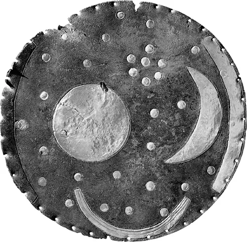
One of the first recorded images of the sky is a hammered copper and gold plate made sometime between 2000 and 1600 BCE, part of the Bronze Age Únětice culture. Discovered in the Saxony-Anhalt region of eastern Germany, it appears to depict the sun or the full moon, a lunar crescent, and stars. To our modern eyes, it also seems to feature the Pleiades—likely, as this star cluster is clearly and prominently visible to the naked eye in the night sky. This metal disk may have been a sort of observational notebook, with new information added over time. One such addition is two golden arcs along its sides, which seem to mark the positions of the sunset at the summer solstice and the winter solstice, thus tabulating the locations of the sun during the longest and shortest days of the year. Another is the arc at the disk’s bottom, from which multiple lines emanate and which is variously interpreted as the Milky Way, a rainbow, or a many-oared solar barge, the sun’s mythological means of transportation. We know so little about how this object was used. But we can speculate that those who employed it somehow connected what happened on earth to what happened in the heavens.
The Nebra Sky Disk (2000–1600 BCE) is an artifact from the Bronze Age Únětice culture, excavated in 1999 in Saxony-Anhalt, Germany. Courtesy Landesamt für Denkmalpflege und Archäologie Sachsen-Anhalt, Juraj Lipták (State Office for Heritage Management and Archaeology Saxony-Anhalt, Juraj Lipták).
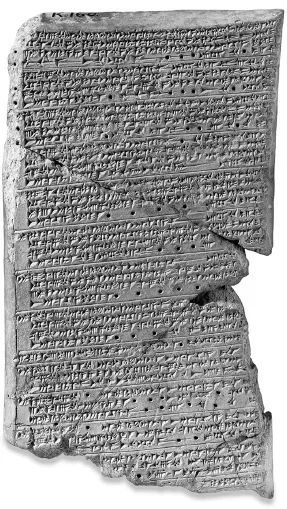
We also know that the Babylonians, who looked out into the sky some nine hundred years later, were sophisticated recorders of astronomical information. The British archaeologist Austen Henry Layard and his nineteenth-century expedition that aimed to unearth the great biblical cities in Mesopotamia excavated and recovered a rich haul of meticulously tabulated astronomical data. Their find included copies of even more ancient observations that the Mesopotamians had compiled and chronicled. Nestled among the thousands of cuneiform tablets that Layard and his team disinterred in what is now Iraq was a document recording observations of the planet Venus.1
The Venus Tablet (seventh century BCE), believed to be part of a longer Babylonian astrology text, Enuma Anu Enlil, that connects celestial phenomena to omens. © Trustees of the British Museum.
Archaeologists believe the Venus Tablet was created during the reign of King Ammisaduqa, and it is just one of several hundred thousand documents that reveal the extent of the Babylonians’ interest in recording astronomical data. Translations of the cuneiform show that Babylonians could distinguish between stars that twinkled and planets that shone as steady spots of light. They knew there were five such wandering points, which moved separately from the stars. The English word planet reflects this earliest description, originating from the Greek planētai, for “wanderer.” Relative to other stars, one orb moved from west to east every night. The strangest thing was that about every two years it reversed its motion entirely for some ninety days and then switched back to its eastward journey. The Babylonians recorded this object and its peculiar backpedalling. We now understand this apparent motion of Mars to be a result of the combined movements of that planet and ours—as Earth and Mars pass on their respective paths around the sun, Mars seems to go backward in the sky. The Babylonians were looking for orderliness and had detailed observations of the bizarre motion of the reddish planet, including its unusual backtracking. Comets, which can appear anywhere in the sky and are visible only briefly before vanishing into the darkness, were seen as harbingers of doom, bad omens portending disasters on earth. From their detailed chronicling of the movements of orbs in the night sky, it is clear that many ancient civilizations noted the regularity of the heavens and strove to predict future positions. Successfully doing so probably helped them to come to terms with nature. The maps of the ancients drew connections between the celestial and the terrestrial.2
Today we use astronomical data to support or overturn astrophysical concepts and models, but in ancient times human understanding of the heavens had a more intimate connection to quotidian events. Registering current celestial events was in the service of predicting future ones, but the ancients were not seeking to explain patterns or to arrive at their causes. Their goal was to record movements and to develop descriptions that would enable accurate future prediction. This is the root of astronomy—observation. Seeing and recording how objects move in the sky eventually gave birth to a science, even if the original explanation for these objects’ movements was anything but scientific. This early tradition that centered on taking data from the night sky was crucial. It gave society an instinct— to connect our place on our planet to our location in the cosmos.
Despite the Babylonians’ inability to scientifically understand the motion of the wandering orbs, their observational data had practical and religious purposes—patterns in the sky, for example, were of great importance to agricultural cycles on the ground. Consider this observation from the Venus Tablet: On the fifteenth day of the month, Venus disappeared from the heavens and remained unseen for three days. Then on the eighteenth day of the eleventh month it reappeared in the eastern sky. New springs began to flow, the god Adad sent rain, and the god Ea sent his floods.3 The retrograde motion of Venus meant downpours on earth. In Hindu mythology, Indra, the supreme deity and god of storms, is variously referred to as the Lord of Lightning, the Storm Gatherer, and the Bestower of Rain. He is eternally engaged in fighting demons from the underworld and battling evil on behalf of the forces of good. He is the demiurge—an artisan or worker figure who was believed to fashion and maintain the physical universe, responsible solely for the material world, not the creator—who pushed up the sky and released dawn, therefore requiring appeasement to keep up the regularity of night and day.
Because the data itself was not used to reveal physical causes at that time, the ancients, lacking advanced technology and theory, invented astrology. Ancient Indian astrological tradition, for example, partitioned the night sky into houses of the zodiac, replete with elaborate mythological stories that accounted for their shapes. Each planet had a ruling lord and an associated temperament. Mars, for instance, was warriorlike and made its natives (those born in its portion of the natal chart) aggressive, argumentative, lovers of weapons, and bestowed with technical and mechanical abilities.
The shift to a world view rooted in logic, data, and evidence had to wait for the ancient Greeks. The origin story that held sway when they appeared on the scene was one in which the world rested on the back of a turtle, which was supported below by yet another turtle . . . with turtles all the way down. This image (sometimes with minor variations) was the prevalent belief right up to the sixth century BCE. But compared to the established cities and kingdoms of antiquity, such as Jerusalem and Babylonia, there was something radical, novel, and dynamic about the emerging Greek world. Unlike ancient kingdoms, it consisted of several politically independent city-states, autonomous and fragmented. Marked by openness to question and debate, this burgeoning culture remade the pantheon that ruled the heavens. Gods were refashioned and more power and agency transferred from the divine to the human. In fact, the divine even reflected human flaws, narrowing the schism between godly perfection and human imperfection.
Into this setting, in 610 BCE on the Ionian coast in the town of Miletus, in present-day Turkey, Anaximander was born. He is attributed with seeing the earth as a cylinder floating in space surrounded by the heavens, not held aloft by any creature. He is acknowledged as the first person to deduce that the earth was freely suspended. This was a profound change in world view, an incredible leap that was emblematic of his entire take on the cosmos.
Supremely radical though this was, it wasn’t just what Anaximander thought about the relationship between the earth and the heavens that was so transformative, but also the intellectual process by which he arrived at his ideas. Although his teacher Thales is credited with abandoning mythological explanations, Anaximander is said to have set in motion the rethinking of our world, igniting a search for knowledge grounded in questioning and challenging what appeared to be fixed and certain. This kind of inquiry is a prerequisite and defining element of any form of critical thinking—but especially our current scientific approach. Anaximander’s attempt to explain nature and elucidate the origin of humans and the world with one encompassing account was one of the most imaginative and earliest, if not the first. If there is a moment in history that we can pick out as a turning point, it was then—when Thales and Anaximander, both residents of Miletus, were formulating a radical new world view. Anaximander did not passively accept the status quo; he sought knowledge and realized that it was continually evolving. His understanding was neither absolute nor static. It required questioning, scrutiny, and continual reformulation.4
One of the roots of the critical thinking that is the linchpin of all astronomy is the desire to question, driven by curiosity. Another is humanity’s continued desire to know and to represent what is known as a map. We cannot underestimate the importance of this literal and practical tie between the heavens and the earth, which developed with geodesy—the science of global positioning. One tool that eventually proved crucial for geodesy was the magnetic compass invented by the Chinese in about 200 BCE. Made of lodestone, a naturally occurring magnetic material found in the ore magnetite, these compasses align with the earth’s magnetic field. But at that time, lodestones were used only for purposes like feng shui, harmonizing oneself with the surrounding environment. It was not until around 1040 CE that the Chinese themselves used compasses for terrestrial navigation or military purposes, and it took another hundred years before their use spread to maritime navigation. How the knowledge of magnetism disseminated from China to the West is still a matter of debate among historians, but there is ample evidence that it was the Chinese who invented the compass. So the rest of the world had to wait for the compass, and the major impetus for mapping’s advancement in ancient times required more than the terrestrial—the heavens had to be mapped. Stars at night helped the ancients to navigate the oceans, and our sun allowed them to measure the size of the earth.5
One of the early milestones in mapping was the estimate in 240 BCE of the circumference of the earth by the Greek astronomer Eratosthenes, who noted that in the town of Syene (modern-day Aswan) on the longest day each year (the summer solstice) there was no shadow cast at noon. He was aware that the sun was not directly overhead on the same day in his hometown of Alexandria along the Nile in northern Egypt, so he estimated the discrepancy in its position by calculating the angle produced by the shadow of a tall tower in Alexandria. Using geometry and knowledge of the distance between the two cities, he arrived at a figure for the circumference of the earth that was just about 16 percent off the modern measurement of about forty thousand kilometers (twenty-five thousand miles).
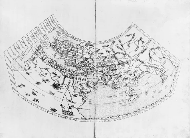
Mathematics allowed a radical new approach to thinking about the cosmos—a move away from mythos to logos, to a physical and geometrical conception of motions that allowed the characterization of regularities. Hipparchus of Nicaea (190–120 BCE) is considered one of the greatest ancient astronomers. Many credit him with the invention of trigonometry and with producing the first effective models for the motion of the sun and the moon. He likely had access to Babylonian records of eclipses and positions of the planets. Building on work they and the Mesopotamians had done, Hipparchus assembled an up-to-date star catalog and developed what are believed to be the first quantitative, geometrical and mathematical descriptions of astronomical data. In the second century CE, the Greco-Egyptian astronomer, mathematician, cartographer, and astrologer Claudius Ptolemy took the next major step toward understanding the motion of heavenly bodies. Inheriting Hipparchus’s three-hundred-year-old data, he collated all the astronomical tables and geometrical models of the Greeks into a comprehensive treatise, the Almagest. But he did more than just compile. He constructed a new model of the heavens, which was consistent with all the available data.6
A copy of Ptolemy’s world map (1478). Ptolemy knew that the earth was a sphere, and his projection measures latitude from the equator, a convention still in use today. Courtesy of the Library of Congress.
Ptolemy’s physical model consisted of nested spheres, and his comprehensive tables allowed the calculation of the future positions of planets. He used four observations spread out in time for each planet to obtain maximum leverage on the estimate of their periods. The oldest observation that he used, from 700 BCE, most likely came from Hipparchus’s compilation of Babylonian records. Given that the primary interest in planetary positions still lay in forecasting events on earth, unsurprisingly Ptolemy was drawn to map the earth as well. While his Almagest records the positions of planets in the heavens as well as periods of the moon, its counterpart, the Geographica, maps the locations of cities and landmarks on earth. Ptolemy conceived the two in tandem: just as he had ordered the celestial realm in enclosed spheres, he assigned locations to all known places on the earth on a grid. Since the planets and the sun move along the ecliptic, Ptolemy used ecliptic coordinates—an earth-centered grid as seen from outside the celestial sphere—to map the star catalog. From this time on, both the earth and the sky were projected with coordinates on the surface of a sphere. Ptolemy mapped the heavens with the stable reference of the ecliptic and the earth with latitude measured from the equator. The ability to predict positions of celestial objects lent the Almagest authority that prevailed throughout the Middle Ages.
The Greeks had also devised the mathematics to study arcs, portions of a circle and the angles subtended by chords that connect the center of the circle to the circumference. But the development of mathematics of course benefited from those beyond ancient Greece’s borders. The Indians expanded Hellenistic mathematics, and in particular the mathematician Aryabhata, working in the fifth century CE, is credited with describing trigonometric functions via infinite series, enabling him to develop extensive tables of values for the sines and cosines of angles. To map the heavens on a celestial globe and the earth on a terrestrial globe, two-dimensional Euclidean geometry needed to be extended to curved surfaces. The Arabs and Indians developed spherical trigonometry from the seventh to the eleventh century. The extension of geometry to describe the relationships between the sides and the angles of triangles on the surface of a sphere was critical to astronomy, to map the locations of stars on a globe; and to geodesy, to understand the impact of the curvature of the earth on navigation as distant locations on earth were now becoming accessible.
Thriving sea trade routes brought Persian and Arab mathematicians into constant contact with the principles of Indian mathematics, which they translated and widel...