![]()
CHAPTER ONE
All Features Great and Small: Landscape Archaeology in Herriot Country
Most people take two days to walk through Swaledale. It is a little less than 30 miles (48km) from the bustle of the market-place in Richmond to the end of the dale, the desolate spot near Hollow Mill Cross from which you may look across the upper valleys of the Eden and the Lyvennet to the mountains of the Lake District. Most of the walk can be done on public footpaths; and you should be on foot, and probably by yourself, to see the fox leap out of the heather a few feet in front of you, the flurry of young wrens in the lane, the brown hare leaving quietly through the gate at the top of the field. You may come here on a chill, still February afternoon, and see a deer standing still as a statue in a meadow beside the Swale; or on a warm and hazy July evening, with shadows lengthening across the shorn, flaxen hayfields. Out on the moors, the landscape is often bleak and forbidding. But in the dale, it is the familiar detail, crafted by people, that Swaledale’s visitors have come to love: the clustering of stone-built, slate-roofed houses beside the roaring beck, the neatly constructed stone stiles along the path through the fields, the smell of new-mown hay. This landscape has been created by past generations of Swaledale people, and in appreciating the dale’s beauty, we are celebrating its history.
Swaledale is marketed as ‘Herriot country’ (though the original Herriot country is forty miles to the east); it is a landscape which has come to symbolise the enduring virtues of Yorkshire folk – their tenacity, self-reliance and capacity for hard work, as well as the warmth of their hospitality. It is all very heartwarming. But as we purchase yet another pot of ‘Mrs Applethwaite’s Traditional Dales Marmalade’, we might just pause to question our fondness for this word ‘traditional’, and ask whether it is destroying our historical understanding. We may be thinking of the people of the Dales rather as we used to think of the Australian aborigines before archaeologists got on the case – as ‘timeless’ people who have practised a simple, unchanging way of life since time out of mind, people essentially without history.
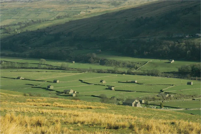
It isn’t true. In fact, Swaledale’s ‘traditional’ landscape of walls and field-barns (Fig. 1.1) is no more than three or four hundred years old. Most of the field-barns, like many of the houses, were built or, more likely, rebuilt in the nineteenth century, and we don’t know very much about what their predecessors looked like. Also, we have to remember that not very long ago this idyllic valley was beset by an industry notorious for noise, dirt and suffering. Whitaker, writing in the early nineteenth century, did not mince words:1
In Swaledale and the adjoining districts, where mining prevails, habits of subterraneous toil and danger, together with seclusion from light and society, while they harden the constitution in general, steel the nerves, and necessarily produce a degree of ferocity very formidable when highly excited. In the mining villages only of Richmondshire are to be found those appearances of squalid neglect about the persons of the inhabitants, and those external accumulations of domestic filth about their dwellings, which sicken every stranger in the worst parts of Lancashire and the West Riding of Yorkshire.
It is not unlikely that the hardships of mining were affecting the social attitudes of the miners and smelters; they were certainly affecting their health and life expectancy. And lead-mining did a great deal of environmental damage. Whitaker reported that ‘hushing’ (releasing water downhill to remove overburden from the ore) was:
detrimental to the spawn by impregnating the water with filth, poisonous minerals, and particles of lead. This for many miles in its descent so pollutes and discolours the river with its thick dirty mud; that it gives it very much the appearance of the washings of the turnpike road after a heavy shower of rain.2
Floods in Swaledale still have a tendency to poison the pastures.
When Whitaker was writing, there were over 1,500 people living in Arkengarthdale alone. And when they took the census in 1851, the little hamlet of Healaugh (pronounced ‘Hee-law’) was occupied by no less than 51 lead-miners, plus a further 11 men occupied in lead-smelting, ore-carrying or as mining agents. And these figures take no account of the women and girls working on the dressing-floors.3 It is all rather a far cry from winning the best-kept village competition! The demise of the lead industry, not much more than a century ago, with the inevitable emigration which followed, created social traumas as harsh as those resulting from the decline of coal-mining in other parts of Yorkshire today.
FIGURE 1.1. The classic Swaledale landscape: walls and haybarns.
So this is a landscape which is only ‘traditional’ up to a point. Traces of very different pasts are there to be observed, discovered and celebrated; even the number of holes in an old stone gate-stoop may have a story to tell (Fig. 10.3). Swaledale’s landscape is intricately bound up with Swaledale’s history, so that without some knowledge of landscape history, the visitor is half-blind – or perhaps we should say semi-literate, in the face of a landscape which is there to be read and understood. This book is about the landscape history of Swaledale. But I want to make it clear that the emphasis is on history rather than landscape, because I do not want to write simply about changing scenery. History is about humans. And landscape history may be rather a special area for writing about human history – especially long-term history – because it is a good meeting-ground for ideas and concrete data, for writing about fantasy as well as hard work; landscape is where, sooner or later, most historical changes and processes make their mark.
So how should we approach the task of reading and writing landscape? An archaeologist may use my own discipline, landscape archaeology, which deals with immensely variable kinds of evidence, from a collection of prehistoric flint implements recovered from a peat-covered moorland to the layout of an eighteenth-century garden. And Swaledale is full of opportunities for the landscape archaeologist. This is mostly because of the nature of the archaeological record here, and the way it has survived. The frequent use and reuse of stone makes archaeological features such as buildings and boundary-walls more durable and visible. On the steep daleside, it is often necessary to cut a platform before erecting a building or an enclosure; many such platforms can still be seen. In the early sixteenth century, John Leland wrote that ‘little corne growith in Swaledale’4 and although medieval ploughing has clearly been very destructive, particularly in Lower Swaledale, the regime of cattle and sheep-farming in recent centuries has allowed archaeological sites to survive as ‘humps and bumps’; their counterparts in lowland England have mostly been flattened by centuries of ploughing. For various reasons, Swaledale farming has tended to be fairly conservative, and landowners, who have usually lived elsewhere, have been more concerned to collect the rents than to promote advanced farming systems. The mining and smelting of lead have been destructive, but the impact of these activities has been mostly on the moorlands. In any case, the mines and associated structures are themselves a valuable and interesting part of the archaeological record.
Landscape archaeologists identify sites and study their relationships, building up historical sequences from humps and hollows. A set of old field boundaries maybe shown to pre-date an earthwork, which itself must be earlier than the roadway which cuts through it. More information can be obtained from these methods than most people imagine. We are still refining our powers of observation and deduction, enjoying the sense of fulfilment which comes from ‘decoding’ new landscapes. But these methods simply provide us with a framework, a stage set without people. Our challenge is to find ways of encountering the people of the past, of making them perform upon our stage. How can we meet this challenge?
For times for which written documents are available – text-aided periods, as archaeologists call them – we can turn to the archives in an attempt to make contact with the people of the past. For Swaledale, the contents of nine hundred years of documents have been summarised in A History of Richmond and Swaledale, published by Roger Fieldhouse and Bernard Jennings in 1978.5 This is a very useful book, the result of a great deal of hard work, much of it by evening class students – five hundred pages packed with information. But it is like quite a lot of document-based local histories. We encounter people as landowners and tenants, heirs and testators, litigants, recusants, traders and wage-earners. This is Swaledale of the scribes; there is not too much action, except in the court cases. We know enough past people’s names to keep the most assiduous Mormon happy, and there are numerous references to sums of money, which seem rather meaningless even after one has worked out what they mean at today’s prices. And how do these people relate to their landscape? It turns out that places are simply where named people happen to have lived or owned property; Swaledale itself is represented mainly by fourteen photographs, and the closest encounter with the material world is that fascinating bit where the authors work out the contents of seventeenth-century houses, room by room, using the wills made by their occupants.
And this, it seems to me, is how local history should be. Humans organise and manipulate their world. There is a great deal of meaning in the way a room is furnished and decorated, the layout of rooms within a house, buildings in a farmyard, houses on a street, settlements and parcels of land within a township. Places have many meanings, involving myth and history, work and recreation, hopes, fears and fantasies. Change in the layout of houses, fields and farms often reflects profound change in other spheres. Documents rarely convey the sense of a Swaledale township as a theatre for action, as a land for work and dreams, reaching from the meadows by the Swale to the cluster of houses around the green and out to the ‘stone men’ on the moorland horizon.
In this book, then, I will try to work with those bits of the documentary record which reflect the actions and thoughts of people in their landscape. But I have also been working with another source of evidence, one which has proved surprisingly interesting and informative – toponyms (the names of places), fields and natural features. Names have their own archaeology. The experts often remind us that names change drastically, so we must seek the early forms. The way Yorkshire surnames have changed over the centuries is a vivid illustration of this point, reminding us that common speech has no respect for history! Thus Baxenden can become Baxendale and then Bassinder, Catlowe becomes Tatlow, Stancliffe becomes Stankley and then Stankler, and so on.6 Swaledale place-names are much the same. One cannot guess that Barney Beck was once Bernopbeck (or Bernolfbeck), or that Straw Beck was once Trow Beck. A 1718 list of boundaries shows Little Pinsett Standard not far from Little Punshot Standard.7 It is disconcerting to realise that modern ‘Pinseat’ and ‘Punchard’ are probably versions of the same name, their bogus difference fixed a long time ago by lawyers’ clerks and mapmakers, who are liable in any case to mishear or misunderstand the names which they are given. There are pitfalls for the unwary here.
But we have to try to get to grips with place-names. As our leading expert, Margaret Gelling, has shown, they are not simply puzzles for linguists; knowledge of the local landscape can be crucial in deciding between different interpretations, or understanding the particular meanings of certain names. Individual place-names are like historical snap-shots, but they can also be grouped into patterns, forming a rich historical source. Unfortunately, the standard work on North Yorkshire place-names was published nearly seventy years ago.8 But the place-name study for Westmorland, a county with much the same history as Swaledale, was published in 1967; I have found that volume, and the one for Cumberland, much more useful.9
Toponyms are a fascinating, under-explored field of study. Finding out the meaning of individual names is rewarding in itself, especially when one is trying to think about the relationship between people and landscape in an area like northern England, where Britons, Angles, Scandinavians and Normans all made their linguistic contributions. There are several different words for woods, clearings and outlying pasture stations, for instance. What was important about a place, when it was named? Its physical character – the shape of a hill, for instance? Its vegetation – characteristic or unusual? Something distinctive about the wildlife of the locality? The names of its owners or occupiers? The use to which it was put? Or was it best defined by its man-made structures?
In Swaledale, names set puzzles. Why are there certain patterns in the way places have been given their names – and why the exceptions? Why do some places have more than one name? Why do some names not fit the places which they are supposed to describe, or seem to have got displaced? Why do old names hang around for hundreds of years after they have apparently been superseded – and, if they can do this, why are they supplanted at all? Some historians say that names stabilise when title to land starts to become document-based (‘book land’); but this is an oversimplification. (In west Wales, in the late twentieth century, the names of farms are still being changed.) Clearly, toponyms are not static things, to be pigeon-holed with the words ‘oh, so that’s what it means, then’. They are picked up in documents, but they reflect historical relationships between human beings, land and landscape which are very far from the concerns of clerks and mapmakers. These early recorded toponyms give documents their own form of prehistory. Landscape too has its prehistory, of course, and when we get back to the period which even place-names cannot reach, we have only archaeological evidence to work with – the results of archaeological excavat...