- English
- ePUB (mobile friendly)
- Available on iOS & Android
eBook - ePub
Trusted by 375,005 students
Access to over 1.5 million titles for a fair monthly price.
Study more efficiently using our study tools.
Information
Print ISBN
9781786575951
Around Yosemite National Park
Yosemite Gateways
South of Yosemite (Highway 41)
Eastern Sierra
Around Yosemite National Park
Why Go?
Though many consider Yosemite the crème de la crème of the Sierras, you may just find you prefer the flavor of other regions around it. You’ll find many who’d argue the unbeatable merits of the Eastern Sierra, which is home to sights such as Mono Lake, Mammoth Lakes, hidden hot springs, shimmering alpine lakes and some of the state’s most dramatic mountain scenery.
Heading to Yosemite by car or bus, you’ll travel along one of four primary approaches. To the west, Hwys 120 and 140 provide the main access routes, with wonderful little goldrush-era towns and groovy old-time saloons. To the south, Hwy 41 passes by pastoral fishing lakes and mountain roads, and the eastern route over Tioga Pass is the highest auto pass in California.
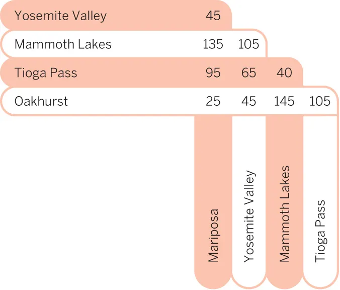
Road Distances (Miles)
Best Places to Eat
A Skadi
A Erna’s Elderberry House
A Erick Schat’s Bakery
A Convict Lake Resort Restaurant
A Ohanas 395
Best Places to Stay
A Hotel Charlotte
A Mammoth Mountain Inn
A Yosemite Bug Rustic Mountain Resort
A Tenaya Lodge
A Inn at Benton Hot Springs
Around Yosemite National Park

YOSEMITE GATEWAYS
Gateway towns to Yosemite National Park are spread over a large and disparate region. While they’re not unappealing in their own right, the towns are overshadowed by the parks nearby. Oakhurst is the least charming of the gateway towns, but it’s a logical choice if you’re combining a visit to Yosemite with a trip to Kings Canyon and Sequoia National Parks. Fish Camp is only 3 miles from Yosemite’s southern entrance, but its sleeping and eating options are comparably scarce. Groveland, the most northern gateway, offers access to lesser-visited sections of Yosemite. However, drives can be long if you plan to visit Yosemite Valley in summer. It’s the same with Mariposa, which has a busy Main St and several Old West museums. Scenic Merced River Canyon is the closest to the valley, but most of its lodgings are of debatable value.
Highway 140
The approach to Yosemite via Hwy 140 is one of the most...
Table of contents
- Table of Contents
- Welcome to Yosemite, Sequoia & Kings Canyon
- Yosemite, Sequoia & Kings Canyon Map
- Yosemite, Sequoia & Kings Canyon Top 16
- Need to Know
- What’s New
- If You Like…
- Month by Month
- Itineraries
- Activities
- Travel with Children
- Travel with Pets
- Yosemite National Park
- Around Yosemite National Park
- Sequoia & Kings Canyon National Parks
- Yosemite, Sequoia & Kings Canyon Today
- History
- Geology
- Wildlife
- Conservation
- Clothing & Equipment
- Directory A–Z
- Transportation
- Health & Safety
- Behind the Scenes
- Our Writers
- Map Legend