![]()
PART ONE
The Story of a Lake
![]()
1
THE MAKING OF A LAKE
Tidal Waves, Monsters, and Dead Zones
Compared to the millions of millennia that water has existed on Earth, Lake Erie is but a mere newcomer. Its current form is less than 4,000 years old. Nor will it remain thus for much longer.
Lake Erie is a product of the last ice age. For thousands of years, massive glaciers covered most of eastern Canada, and parts of the northeastern United States, an ice sheet that some scientists estimate may have been more than three kilometres thick in some places. What the land looked like before this big freeze is anybody’s guess. What is known is that the basins occupied by today’s Great Lakes likely existed in some form, and were deepened by the enormous scouring of the advancing ice sheets.
But some 20,000 years ago, when the earth began to warm again, and the ice began to melt, the glaciers did not recede in a uniform way. Rather, the mass broke into irregular lobes, one forming to the east of today’s lake, another to the north. As the ice melted, a lake formed, which scientists have named Lake Maumee.1 While its elevation varied during the melt, its waters flowed westward through today’s Michigan, and then down the Mississippi.
But the great glaciers weren’t done yet. A cold snap enlarged them once more, creating yet a different lake, one which was named Lake Whittlesey, but whose waters again flowed west through Michigan. Then the glaciers retreated once more and exposed a startlingly different outlet for the lake waters, through an earlier version of today’s Niagara Gorge. Then, when the ice sheets advanced yet again, and filled the gorge with glacial debris, that outlet became blocked and the waters were forced eastward through today’s Mohawk Valley in New York State.
Finally, the ice began to recede for good. As it did, the Niagara Gorge again became Lake Erie’s outlet. Because the original gorge was now filled with debris, the waters carved out a new channel. That channel is marked by today’s Niagara Gorge, where it begins its sharp bend at the famous whirlpool. The old gorge, now buried, lies between the whirlpool and the community of St. David’s.
But because the enormous weight of the ice continued to depress the land, that outlet was about fifty metres lower than it is today, and so too were the waters of Lake Erie. That lower elevation meant that much of the lake’s western section stood high and dry, an area that today lies west of Long Point. The islands of the western lake, Pelee Island, Middle Island, and the American islands formed a land bridge, allowing the passage of animals and some of the earliest human inhabitants.
Finally, about 4,000 years ago, with the ice far to the north, its weight gone, the land around the Niagara Gorge began to rise, allowing the lake to fill to almost its present levels.
But how much longer will it survive as a lake? As the great falls of the Niagara River continue to erode their way upstream, they will eventually reach Lake Erie itself, where as they erode farther into the lake bed, will lower the lake and turn it into a massive river.
The Shape of the Lake
Despite being one the smallest of the “Great” Lakes, Erie, at nearly 26,000 square kilometres, remains the tenth largest in the world. Among the Great Lakes, however, only Ontario is smaller by volume. Nearly 390 kilometres long, the lake at its widest is ninety-two kilometres. It is however, the shallowest of the lakes with an average depth of only nineteen metres. While its deepest points, east of Long Point, plunge to sixty-four metres, its western waters go down a mere thirteen metres. Still, it remains the only one of the lakes whose lowest point is actually above sea level.
With only a handful of rivers flowing into it, Erie’s waters are provided mainly by the Detroit River. The Niagara River remains its sole outlet. Because of its shallowness, the waters of the lake renew themselves completely once every two-and-a-half years.2
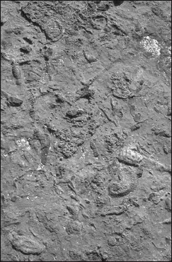
Rock Point Provincial Park offers fossil displays in its shoreline bedrock.
Of its total shoreline length of nearly 1,400 kilometres, slightly less than half lies in Ontario, the remainder laps the shores of the American states of Michigan, Ohio, Pennsylvania, and New York. Those states contain no fewer than three counties which bear the name “Erie,” while none of the six counties or regions on the Ontario side carry the name of the lake on which they lie.
Unlike the rocky Ontario northlands, Lake Erie’s physical shoreline characteristics have resulted directly from the forces of the last ice age, although moderated somewhat by wind and water. The eastern section of the shore is a level and poorly drained clay plain with few shoreline features. Beaches and sand dunes alternate with flat, rocky headlands, the latter often exhibiting spectacular fossil displays (Rock Point Provincial Park is one of the best sites from which to observe them). A flat, limestone shoreline surrounds the elusive Point Abino lighthouse. Inland lie extensive areas of peat bogs.
Port Colborne marks the entrance to the busy and historic Welland Canal, completed in 1927. Immediately to the west of the harbour looms a soaring dune locally named the Sugarloaf, a feature which still serves as a navigation aid for vessels plying the lake.
The only significant break in the shoreline comes at Port Maitland where the wide, sluggish waters of the Grand River seep into the lake. A heritage waterway, the Grand begins its run in a wide swamp north of Dundalk in a wide swamp known as the Osprey Wetlands. As it winds its way southward through cattle country it gradually picks up tributaries until, at Grand Valley, it begins to resemble a river. At Fergus it begins to tumble through the fairyland rockscapes of the Elora Gorge, where hole-in-wall and dry waterfalls rock formations have created an almost otherworldly waterscape. Beyond the gorge, it has carved out a wide, meandering valley where the water power gave rise to a string of mill towns with names like Conestoga, Galt, Glen Morris, Paris, Brantford, Caledonia, and Dunnville, which is situated at the mouth of the river. The river is wide, its banks marshy and home to a variety of wildlife species.
West of the Grand, the shoreline continues to be low and occasionally rocky, interrupted only by a few small creeks, such as Stoney Creek, which provided mill sites for the community of Selkirk, and Nanticoke Creek, which performed the same role for the village of Nanticoke. In the latter community the cove created by the creek’s entrance into the lake was large enough to spawn a small harbour.
Finally, west of Nanticoke, the typical cliffs of Lake Erie begin to appear, inspiring the appropriately named Port Dover, named after the famed cliffs in England. Here, the confluence of the Lynn River and Black Creek have cut through the cliffs, creating water power for mills and allowing a deep and protected harbour for schooners and fishing boats. It is here that the shoreline enters a region known as the Norfolk Sand Plain. This historic area is the result of an extensive delta laid down when the waters of the melting ice sheets poured into the waters of a higher Lake Whittlesey. Here, the cliffs of sand and clay reach heights of twenty-five to thirty metres. Along the way, creeks have carved deep valleys and spawned little ports such as Normandale and Fishers Glen.
One of the highest points overlooks Turkey Point, a promontory that briefly proved useful for a military role. Inland, the sandy soils attracted a community of farmers, grateful for the stone free and tillable soils. However, the sands quickly lost their fertility and by 1900 were largely abandoned. Winds turned extensive stretches of farmland into a blowing sand desert. Reforestation halted much of the erosion until it was discovered, in the early 1920s, that these conditions were ideal for tobacco and the region soon became Ontario’s most productive tobacco belt.
The next stretch of shoreline contains one of the lake’s most prominent natural features, Long Point, and is now a UNESCO World Biosphere Reserve. The reserve boundary incorporates both the long spit and Turkey Point, as well. The two points of land nearly encircle a shallow bay, with the latter spit extending to the southwest and the former to the southeast.
The point, which juts thirty kilometres into the lake, contains the most extensive and varied collection of ecosystems among the entire Great Lakes shorelines. Ever shifting, it continues to be formed by sands and silts swept easterly by the lake’s currents. The Turkey Point section, however, owes its orientation to currents circling from the east. Beyond the intense development of cottages near the neck of Long Point, the protected section harbours more than 270 species of birds and 700 plant species, 90 of which are classified as rare. Shallow bays, sandbars, dunes, scrublands, ponds, and marshes are all found along the extensive spit.
Designated in 1986 as a UNESCO World Biosphere Reserve, it is one of only three in Ontario and one of six in all of Canada. With most of it now under the ownership of the Canadian Wildlife Foundation, the reserve consists of the core protected zone, and a wider buffer zone that extends into the lake as well as along the shoreline.
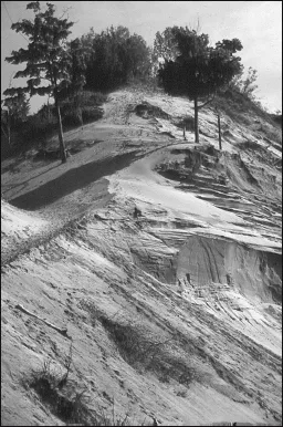
As Lake Erie’s shoreline continues west from Long Point, the bluffs resume once more. But among them lies one striking anomaly, the Houghton Sand Hills. Unlike the uniformity of the cliffs to this point, silt and sand, the sand hills are nothing but sand. It has earned its local nickname, Ontario’s “biggest sand pile.” For a stretch of about two kilometres, these mounds of pure sand loom nearly one hundred metres above the lake. As with much of the Erie shore, the sand pile traces its origins to the massive stream of meltwater which poured from the glaciers into the higher waters of Lake Whittlesey.
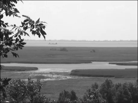
The Turkey Point marshes contain a vital ecosystem and form part of the Long Point
UNESCO World Biosphere Reserve.
Again, the bluffs lower until they reach yet another of the Erie spits, Point aux Pins. This 1,800-hectare peninsula of early Carolinian forests curves eight kilometres into the lake enclosing a large, shallow bay known as Rondeau Bay.
The stretch of shoreline between these two points is also notable for the lack of rivers or major creeks that flow into the lake. A series of beach ridges and remnants of Lake Whittlesey force most drainage northward into the Thames River watershed, which parallels the Erie shoreline in this area.
The next Erie spit is probably the lake’s most famous, better known than even Long Point. That is Point Pelee. It is known especially for being the most southerly point of mainland Canada, with a latitude more southerly than northern California. It is known too, even among non-naturalists, as being one of the most spectacular gathering places for the monarch butterfly as they annually migrate to the mountains of central Mexico.
At ten kilometres long, it extends almost straight into the lake, formed by currents that attack it from both east and west. Beaches line both sides, culminating in a pencil point of sand that stabs into the lake before narrowing and slipping beneath the waves. The length of this spit can vary from year to year. It can stretch two kilometres from the edge of the forest, or it can disappear entirely as it did in 2007, following a particularly stormy spring.
The Houghton Sand Hills were once a massive sand delta when Lake Erie’s water levels were much higher.
Its natural makeup is outstanding. It contains dense Carolinian forests of silver maple, black walnut, red cedar tulip, and honey locust trees, many of them wrapped in vines of Virginia creeper and poison ivy. Open savannahs display rare grasses and cactuses. An enclosed marsh is covered with water lilies, bulrushe...