2017 Gertrude H. Dyke Award — Nominated The history of Lake Nipigon, where the Great Lakes begin. The name Nipigon is evocative of storied brook trout, cold clear waters, elusive woodland caribou, sweeping vistas, and spectacular scenery. Situated in the heart of Northwestern Ontario, almost every map of North America shows Lake Nipigon as a significant geographic feature, yet few people know its story. As the primary watershed that flows into Lake Superior, Nipigon is the headwaters of the Great Lakes. This, the first inclusive historical account of Lake Nipigon, provides a fascinating overview of its extensive natural history, including information on species at risk, and interprets the story of human incursion into the area, from its aboriginal prehistory to the colourful fur trade, the harvesting of resources, the coming of the railway, recreational fishing, eventual settlement, and the communities that remain today.
- 307 pages
- English
- ePUB (mobile friendly)
- Available on iOS & Android
eBook - ePub
About this book
Trusted by 375,005 students
Access to over 1.5 million titles for a fair monthly price.
Study more efficiently using our study tools.
Information
One
Background on the “Mother of the Great Lakes”
Heaven meets Earth on Lake Nipigon.— author unknown
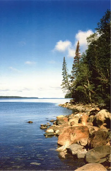
There is a place in Northwestern Ontario where the Great Lakes begin — a vast and remote lake of primeval beauty, set in a wild and rugged landscape. It is epic and immense, a near-pristine wilderness of crystal-clear waters, trophy brook trout, towering cliffs, hulking islands, brooding headlands, expansive forests, and spectacular vistas. Here at the northern edge of civilization lies this primitive lake, full of mystery and possibility, with seemingly limitless opportunities for extended exploration and profound wilderness experiences — truly a place of grandeur and beauty.
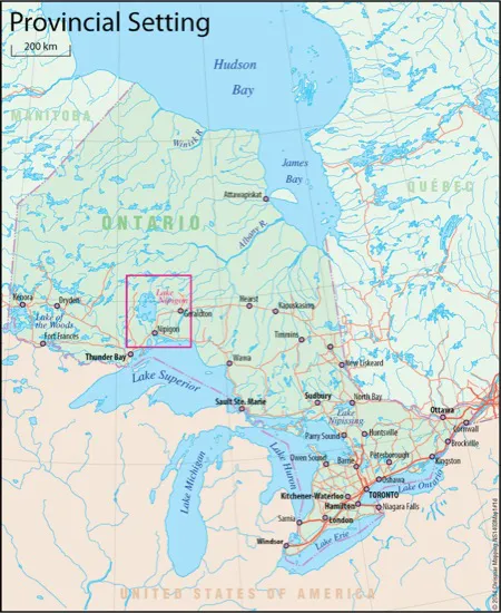
This is Lake Nipigon, sometimes called the “First Great Lake.” Lying to the north of Lake Superior, this magnificent body of water and its surrounding basin comprise the first and the largest watershed flowing into the Great Lakes chain. Fed by Lake Nipigon and its surrounding watershed, the Nipigon River is Lake Superior’s most northerly and largest tributary. It is indeed fitting that Lake Nipigon is sometimes referred to by First Nations elders as the “Mother of the Great Lakes,” since, given its geographic position, Lake Nipigon is the true headwaters of the Great Lakes.
Lake Nipigon, located in Northwestern Ontario, is the largest inland lake in the province. © Chrismar Mapping Services Inc.
Nipigon — the name has long designated the geographic features of a lake, a river, a town, and a bay in Lake Superior. But where did this name come from? In the tongue of the seventeenth-century Ojibwa, the word for Lake Nipigon was Animi-bee-gong (or Anemebegong), which became anglicized to Annimipegon. This Ojibwa name translates loosely as “the lake that extends over the horizon” or, alternatively, “the lake that you can’t see the other shore,” or, most commonly, “the lake you have to cross to get somewhere else.”[1]
The first references to Lake Nipigon by Europeans occurred in the mid-1600s. Throughout the next centuries, it was subsequently referred to by a wide variety of names. Most of these were based on variations of the Ojibwa word. During the early years of the French fur trade, the lake was known by variations of the Ojibwa name Annimipegon, sometimes shortened to Lac Ste. Anne. After his visit to the area in 1683, the French explorer Daniel Greysolon, Sieur Du Lhut, called it Lac Alemipegon, but a host of variations were also used, such as Alimbig, Alemembigon, and Alimibon.[2]
In 1703, LaHontan’s general map of New France shows the name of Lake Nipigon as Lac Menipogong. A later French map, produced by Henri Chatelain in 1719, shows the lake as being called Lac de le Nempigon. In 1755, yet another French map, this one by Jacques-Nicolas Bellin, refers to it as Lac Alimipegon.
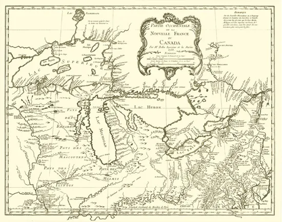
A map from 1755 showing Lake Nipigon as Alimepigon, entitled Partie occidentale de la Nouvelle France ou Canada, was created by cartographer Jacques-Nicolas Bellin in 1755. Courtesy of Library and Archives Canada, H2/903/1755.
With the proximity of Lake Nipigon to Trans-Canada Highway 11 and other lesser roads to the south and west, it is remarkable that the lake has not seen more development. There is still no road connection that traverses the area north of the lake. © Chrismar Mapping Services Inc.
Even as late as the 1970s, local indigenous peoples would still sometimes refer to the lake as a shortened version, Nimbik, meaning “big water.” Following a long evolution spanning several centuries, around 1900, the word Nepigon finally developed into its present form, Nipigon.[3]
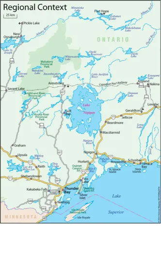
Situated in the heart of Northwestern Ontario, Lake Nipigon is shown on almost any map of North America as a major feature of the continent.[4] With a perimeter of about 1,050 kilometres and a total surface area of 4,848 square kilometres, Lake Nipigon is the largest inland lake in Ontario, and the only lake in the Great Lakes Basin that’s contained entirely within Ontario and Canada. Measuring one hundred kilometres long and seventy kilometres wide, Lake Nipigon is the thirteenth largest lake in Canada and, by area, the thirty-second largest lake in the world.
Located in the Precambrian Shield, Lake Nipigon lies some fifty kilometres north of Lake Superior and the town of Nipigon, and about one hundred kilometres northeast of Thunder Bay. With an elevation of 260 metres above sea level, and seventy-six metres above the level of Lake Superior, the shape of Lake Nipigon reflects its geological and glacial origins. Situated mid-continent, the lake lies on the fiftieth parallel (fifty degrees latitude) and at eighty-nine degrees longitude, and is therefore nearly at the zero meridian (the line where there is zero declination of the compass).
While this vast and wild lake is renowned for its breathtaking beauty and legendary sport fishing, the area is also well-known for its vast resource potential and extraordinary opportunities for wilderness recreation. The lure of such diverse and inspiring recreational experience makes Nipigon Country an area of enormous fascination and appeal, offering a wide variety of hiking trails, canoe routes, campsites, and sea kayaking opportunities. But its famed fishery continues to be its prime attraction, with its lake and brook trout fishing and trophy northern pike fishery considered to be among the finest in the world.
The natural Lake Nipigon watershed covers an area of about 11,050 square kilometres and extends from Lake Superior in the south almost to the Albany River in the north. The Lake Nipigon watershed lies in the Atlantic watershed but is located just south of the height of land that separates the Atlantic and Arctic watersheds. However, due to the Ogoki Diversion, the Nipigon drainage area now includes the diverted waters of the Ogoki River watershed (including the expansive Wabakimi Provincial Park), which, geographically, is part of the Albany River Basin.
This spectacular image, looking north up Pijitiwabik Bay along the shores of the former Lake Nipigon Provincial Park, depicts land that is now part of the Bingwi Neyaashi Anishinaabek Reserve. Photo by author.
The irregular shoreline with many jutting peninsulas and the numerous islands dotting the lake lend interest to the geography of Lake Nipigon. © Chrismar Mapping Services Inc.
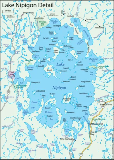
Slightly oblong in shape, the lake has an irregular shoreline with several large bays and jutting peninsulas. The cold, deep, oligotrophic (nutrient-poor) lake has vast expanses of open water with a few protected areas of shallow, somewhat warmer waters. Lake Nipigon contains hundreds of islands, of which about fifty-five are greater than twenty-six hectares in size. The highest island, Inner Barn, towers up about 170 metres above the lake’s surface, while the cliffs and headlands can rise up to over 180 metres.
The waters of Lake Nipigon make up about 90 percent of the lake’s area, leaving an island area of around 10 percent of the entire lake. Although Lake Nipigon has never been completely sounded, to date the lake’s maximum recorded depth is 166 metres. Meanwhile, the average depth is estimated to be forty-six metres.[5] The water-renewal time for Lake Nipigon is thought to be about twenty-five years, meaning that, if drained, it would be twenty-five years before the lake would refill to its present level.
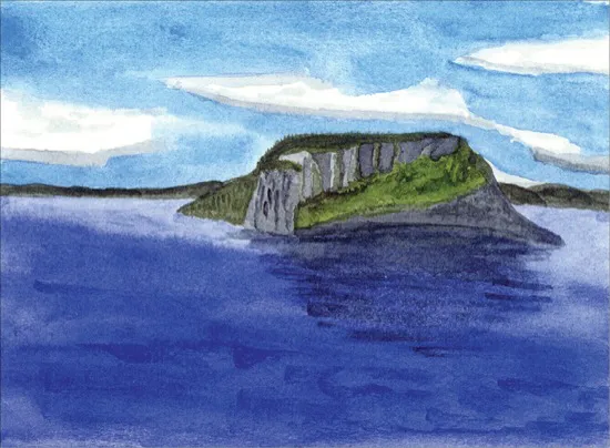
This watercolour of Inner Barn Island, showing its distinctive elevation above the surrounding lake, is the work of Dr. Michael Whittier. An avid paddler, he has spent much time on the waters of Lake Nipigon. Reproduced with permission of Dr. Michael Whittier.
The natural wealth of Nipigon Country has supported a long history of resource use, including fishing, logging, mining, trapping, and tourism. Moreover, the waters of the Lake Nipigon watershed have been harnessed to become a major contributor of hydroelectric power in this region of Ontario. It would seem that such development would have compromised the near-pristine qualities of the area. Remarkably, however, Lake Nipigon appears to have remained relatively unchanged since the days of the coureurs de bois. For the most part, it is still wild and remote; one of the least-developed water bodies in a road-accessible part of Ontario. Given its long history of Aboriginal habitation, the fur trade, and European exploration, as well as the commercial fishery, logging, and mining development in the area, Lake Nipigon has likely seen more activity in bygone years than it does today.
Lake Nipigon’s rich cultural heritage includes numerous archaeological and historic sites. Significant in the prehistory of human culture, the lake has a very extensive Aboriginal history, some of which lives on in pictographs, legends, and Native spiritual sites. Lake Nipigon played an important role in the fur trade, and various fur-trading posts were established here.
That Lake Nipigon has somehow remained relatively inaccessible and wild is indeed astonishing given its location adjacent to a short span of Trans-Canada Highway 11, its proximity to the town of Nipigon and the junction of Highways 11 and 17, as well as being close to the city of Thunder Bay. Despite the lake’s size, location, and rich resource and recreational potential, it is a place that the world seems almost to have passed by.
Only a few settlements and access points dot Lake Nipigon’s untamed shores. In the twenty-first century, the area remains relatively pristine due to limited access, virtually no industry, and remarkably little shoreline development. Throughout its history, there has been little land disposition here, so nearly all the Lake Nipigon area, including the shoreline, islands, and surrounding area, has remained Crown land.
Historically, Lake Nipigon served as a natural corridor for human travel through the region, from pre-settlement times, through the era of early exploration and the fur trade, to the present time. It was the last lake in the Great Lakes chain to be reached by the Europeans, with the Jesuit priest, Father Jean Claude Allouez, being the first to ascend the Nipigon River in 1667.
Likely the most active and colourful historical period was the fur-trade era, which was centred in the Nipigon region where competition for control of the trade was waged for over two hundred years. Between 1679 and 1924, as many as twenty fur-trading posts, belonging to a combination of French traders, the British Hudson’s Bay Company (HBC), Montreal’s North West Company (NWC), and various independent traders, were established throughout Nipigon Country. During the early period, rivalry was often fierce, with various traders and posts trying to out-compete one another in this fur-rich region.[6] Aggressive competition ended in 1821, with the amalgamation of the companies into a Hudson’s Bay Company monopoly. The fur trade in Nipigon Country continued well into the 1900s.
The major staging areas were along Lake Nipigon’s north shore, where trading posts and habitations were established to intercept the HBC furs destined for Albany River and, eventually, Hudson Bay. Posts were built at strategic locations on the major waterways of the fur-trade routes, at the mouths of the Little Jackfish and Onaman Rivers on Ombabika Bay, and farther west, at the Pikitigushi (Mud) River.[7] Apart from a few clearings and the occasional artifact, little remains of the colourful fur-trade era on Lake Nipigon.
In addition to its significant cultural heritage, the Nipigon watershed has one of the most impressive arrays of geological, landscape, and vegetation assemblages in Northwestern Ontario, making it a very special and unique part of the province. Its natural values, both geological and biological, include a wide variety of distinctive and intriguing landforms, wildlife, and plants, some of which are provincially unique and very rare. Such significant and sensitive features include its renowned fishery, threatened woodland caribou, rare plants, important bird habitat for bald eagles and pelicans, and intriguing geological and post-glacial landforms. The lake is also significant for its cold, clear, trout-filled waters, an increasingly scarce resource in the world today.
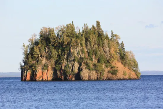
This distinctive island in Castle Bay, in the northwest reaches of the lake, is one of about five hundred islands on Lake Nipigon. Photo by Dr. Michael Whittier.
Among the most striking geological features within the Nipigon Basin are the landmark flat-topped hills and precipitous cliff faces, which are found in many shoreline areas as well as on several of the lake’s islands. These spectacular and distinctive landscapes have been shaped by the lake’s unique geological and glacial past. The myriad of majestic flat-topped hills (mesas) and immense diabase cliffs (cuestas) were sculpted more than a billion years ago when deep rifts formed the Lake Nipigon Basin. As the glaciers were receding, around 9,000 years ago, the Lake Nipigon area was occupied by a northern embayment of glacial Lake Algonquin, and this prehistoric lake separated what is now Lake Nipigon from the developing Lake Superior. During the later stages of this most recent glacial era, the Nipigon Basin was occupied by glacial Lake Kelvin, which formed along the disingrating edge of glacial ice, and was filled with the cold, clear waters of the melting glaciers. Lake Kelvin occupied the rift that formed the entire Lake Nipigon Basin, and drained into Lake Superior. Subsequently, when the water level dropped, it evolved into the present configuration of Lake Nipigon, and the epic lake was born.[8]
While the lake’s scenic and characteristic shoreline is comprised of hills and headlands, there are numerous bays that often contain rocky or sand beaches — a few with unusual black sand. These distinctive black-sand beaches are derived from the surrounding diabase rock, which erodes and is then washed into the lake and then onto the shores by waves. In 1964, Lake Nipigon Provincial Park (as it was later known) was established as Blacksands Provincial Park, this original name reflecting the coal-coloured sands of the park’s main beach, although the intensity of the colour has somewhat diminished here over time.
Much of the area’s distinctive scenery is created by horizontal diabase “sills,” which form a “cap rock” that is resistant to weathering, thus creating plateau mountains skirted by massive cliffs more than 180 metres high. At the base of these mountains are layers of fallen rock known as “talus.” This characteristic and unique mesa-cuesta topography is found throughout the Lake Nipigon area and western Lake Superior. On Lake Nipigon, these features are best exemplified in the prominent box-like shoreline hills and headlands, the imposing distinctive shape of the islands (such as Inner and Outer Barn), and, most notably, the Pijitawabik Palisades.
The palisades are an especially prominent and impressive geological feature, located in the southeast corner of Lake Nipigon at Orient Bay, just east of Highway 11. Named for nearby Pijitawabik Bay, these dramatic cliffs tower more than fifteen storeys and extend for a stretch of about sixteen kilometres. This impressive escarpment was formed about 1.2 billion years ago by a geological process known as vertical “columnar” jointing. Throughout the millennia, frost and water action worked the cracks of the ancient rock, gradually breaking and eroding it, eventually forming these distinctive cliffs with their angular massive stone columns or pillars into their present-day grandeur.
The area around the Pijitawabik Palisades was once a major glacial spil...
Table of contents
- Cover
- Dedication
- Epigraph
- Table of Contents
- List of Maps
- List of Tables
- Acknowledgements
- Introduction
- Part 1
- One
- Part 2
- Two
- Three
- Four
- Five
- Part 3
- Six
- Seven
- Eight
- Nine
- Part 4
- Ten
- Eleven
- Twelve
- Part 5
- Thirteen
- Fourteen
- Part 6
- Fifteen
- Appendix 1
- Notes
- Bibliography
- About the Author
- Copyright
Frequently asked questions
Yes, you can cancel anytime from the Subscription tab in your account settings on the Perlego website. Your subscription will stay active until the end of your current billing period. Learn how to cancel your subscription
No, books cannot be downloaded as external files, such as PDFs, for use outside of Perlego. However, you can download books within the Perlego app for offline reading on mobile or tablet. Learn how to download books offline
Perlego offers two plans: Essential and Complete
- Essential is ideal for learners and professionals who enjoy exploring a wide range of subjects. Access the Essential Library with 800,000+ trusted titles and best-sellers across business, personal growth, and the humanities. Includes unlimited reading time and Standard Read Aloud voice.
- Complete: Perfect for advanced learners and researchers needing full, unrestricted access. Unlock 1.5M+ books across hundreds of subjects, including academic and specialized titles. The Complete Plan also includes advanced features like Premium Read Aloud and Research Assistant.
We are an online textbook subscription service, where you can get access to an entire online library for less than the price of a single book per month. With over 1.5 million books across 990+ topics, we’ve got you covered! Learn about our mission
Look out for the read-aloud symbol on your next book to see if you can listen to it. The read-aloud tool reads text aloud for you, highlighting the text as it is being read. You can pause it, speed it up and slow it down. Learn more about Read Aloud
Yes! You can use the Perlego app on both iOS and Android devices to read anytime, anywhere — even offline. Perfect for commutes or when you’re on the go.
Please note we cannot support devices running on iOS 13 and Android 7 or earlier. Learn more about using the app
Please note we cannot support devices running on iOS 13 and Android 7 or earlier. Learn more about using the app
Yes, you can access Lake Nipigon by Nancy Scott in PDF and/or ePUB format, as well as other popular books in History & Historical Geography. We have over 1.5 million books available in our catalogue for you to explore.