- 128 pages
- English
- ePUB (mobile friendly)
- Available on iOS & Android
eBook - ePub
Grant County
About this book
The large number of immigrants traveling along the Oregon Trail bypassed Grant County because of its location. Most wagon trains used the northern route to the Columbia River. A few used the southern route toward southern Oregon. Grant County was left in between. When gold was discovered in the Canyon Creek area in 1862, the population swelled from scarcely 200 to more than 5,000, many of them Chinese. Today, Grant County's population is approximately 7,500, with John Day, the largest city, at slightly less than 2,000. From the 1860s to near 1900, gold and the mining industry reigned, as upward of $26 million worth of gold was mined. As the supply of gold diminished, so did the population, and timber became the number one industry. Settlers from the East saw potential in the large stands of tall, straight ponderosa pine, and many sawmills came into existence. The sawmills have since greatly declined, but other settlers discovered that the acres of bunchgrass provided excellent cattle feed. Today, cattle is king. In the spring, the cattle herds are moved off their winter grounds to higher elevations; in the fall, they are herded back into the valley. In the past, these movements often took them through the heart of many cities.
Trusted by 375,005 students
Access to over 1 million titles for a fair monthly price.
Study more efficiently using our study tools.
Information
One
THE TOWNS AND PEOPLE
OF GRANT COUNTY
OF GRANT COUNTY

This photograph of John Day was taken around 1904 to 1910. It is looking west from the end of Main Street at the corner of Dayton Street. The image shows the Grant County Bank, Johnson and Parrish, and Blue Front Livery Stable. Today the population is around 2,000, much less than the estimated 5,000 that inhabited Canyon City to the south shortly after gold was discovered in June 1862. John Day was often referred to as “Lower Town” or “Tiger Town.”

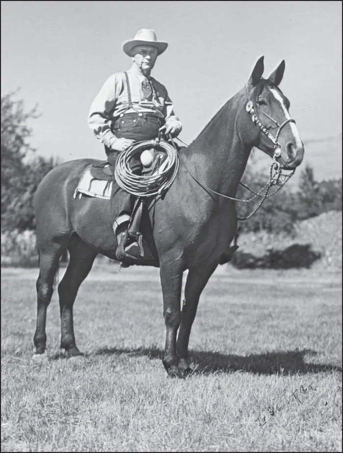
Herman Oliver is considered by many to be the best-known cattleman in Oregon. His name not only brings back memories but also innumerable favorable comments. His methods of breeding, feeding, and pasturing cattle were new and progressive, which attracted professors from Oregon State University. He also served on several state boards and committees. During the country’s hard times in the 1930s, he was principal owner of the Grant County Bank, which stayed open when many other banks closed their doors. His ranch east of John Day, above, at one time stretched over 50,000 acres. He is shown at left riding his favorite horse.

There are and have been many other well-known ranches in Grant County. The Southworth ranch near Seneca in Bear Valley is one. The Southworths go back to the early days of Grant County. The Southworth ranch was started by Jack Southworth’s great-grandfather William Sawyer Southworth in 1885 as a 160-acre homestead. Today, their grazing rights encompass over 25,000 acres. The Southworths are some of the more progressive ranchers in the area. The ranch practices of preserving the environment have won them numerous awards, including Grant County Stockgrower of the Year in 2010 and Conservation Farm Award in 2009. Once, when Jack planted willows along the streams, he was scolded by his father. Those willows now provide needed shade for the streams and the inhabitants. The Southworth spread is shown above. (Courtesy of the Grant County Ranch and Rodeo Museum.)

This early-1900s photograph of the John Day area was taken looking toward the northeast. It shows Highway 26 running from the upper right to the lower left. The Advent Christian Church is in the left foreground, the Methodist church is at right, the Johnson and Parrish building is in the center, and the Basford Roller Mill is at the top center.

This is an earlier photograph of the town of John Day, taken in 1888. Note the Methodist church in the center of the photograph and how the town had changed in less than 20 years. The photograph was taken looking northeast, with the John Day River running through the grove of trees near the top.

John Day is the largest city in Grant County. It is located along the John Day River and lies at the intersection of Highway 26, going east and west, and Highway 395, going north and south. This view was taken around 1910 looking east along the route of Highway 26 today. The large number of people wandering around and the flag suggest some sort of celebration, perhaps around Easter.

This photograph shows John Day around 1910 looking south, with Canyon Creek in the background and the John Day River in the foreground. Main Street runs east to west through the center of the photograph. On the right, it is intersected by Canyon Creek Boulevard.
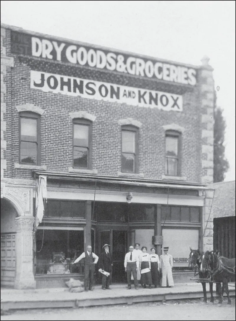
The Johnson and Knox dry goods store was a popular shopping place in the early 1900s in John Day. It was located along Main Street and served the area within 50 miles. Note below all the canned goods on the shelves and the jewelry items in the case with a display of hats on top. From left to right are E.L. Knox, Carl Tucker, and, behind the counter, Theron Knox and Louise Conner.


Travel in the area in the 1800s was generally by stagecoach. This c. 1880 photograph shows the stage in front of the post office in John Day. Stage lines ran from The Dalles to John Day, John Day to Baker City, and John Day to Burns. The trip from The Dalles to John Day took three days, with overnight stops generally in Antelope and Mitchell. These times and stops depended heavily on the weather. Travel was by what was called the Military Road, but to call it a “road” was perhaps a misnomer. The teams of horses, be it four or six, had to be changed often. Stops were often at farm houses. Rivers and creeks had to be forded, as there were no bridges. The driver was in charge, and riders did what he told them to do. He was accompanied by one other person, usually another man with a rifle.

The stagecoach line to Baker City always stopped at Austin in the mountains. Whether going east or west, it had to cross two summits of over 5,000 feet. This stage, sitting in front of Austin House, will soon wind its way down the mountains to Prairie City after the travelers have been served a sumptuous feast.

Mule and horse teams were the only means of bringing goods to the miners. They were also how any commodities left the area. The trip to and from The Dalles traveled the same route along the old Military Road. Mostly six-horse teams were...
Table of contents
- Cover Page
- Half-Title
- Title Page
- Copyright Page
- Dedication
- Table of Contents
- Acknowledgments
- Introduction
- 1. The Towns and People of Grant County
- 2. Mining and the Chinese
- 3. Cattle, Sheep, Farming, and Timber
- 4. Schools, Churches, and Social Organizations
- 5. Recreation and Festivities
- 6. When Disaster Struck Grant County
- 7. Federal and Protective Organizations
- Bibliography
Frequently asked questions
Yes, you can cancel anytime from the Subscription tab in your account settings on the Perlego website. Your subscription will stay active until the end of your current billing period. Learn how to cancel your subscription
No, books cannot be downloaded as external files, such as PDFs, for use outside of Perlego. However, you can download books within the Perlego app for offline reading on mobile or tablet. Learn how to download books offline
Perlego offers two plans: Essential and Complete
- Essential is ideal for learners and professionals who enjoy exploring a wide range of subjects. Access the Essential Library with 800,000+ trusted titles and best-sellers across business, personal growth, and the humanities. Includes unlimited reading time and Standard Read Aloud voice.
- Complete: Perfect for advanced learners and researchers needing full, unrestricted access. Unlock 1.4M+ books across hundreds of subjects, including academic and specialized titles. The Complete Plan also includes advanced features like Premium Read Aloud and Research Assistant.
We are an online textbook subscription service, where you can get access to an entire online library for less than the price of a single book per month. With over 1 million books across 990+ topics, we’ve got you covered! Learn about our mission
Look out for the read-aloud symbol on your next book to see if you can listen to it. The read-aloud tool reads text aloud for you, highlighting the text as it is being read. You can pause it, speed it up and slow it down. Learn more about Read Aloud
Yes! You can use the Perlego app on both iOS and Android devices to read anytime, anywhere — even offline. Perfect for commutes or when you’re on the go.
Please note we cannot support devices running on iOS 13 and Android 7 or earlier. Learn more about using the app
Please note we cannot support devices running on iOS 13 and Android 7 or earlier. Learn more about using the app
Yes, you can access Grant County by George R. Miller in PDF and/or ePUB format, as well as other popular books in History & Agribusiness. We have over one million books available in our catalogue for you to explore.