- 128 pages
- English
- ePUB (mobile friendly)
- Available on iOS & Android
eBook - ePub
Mount Rainier
About this book
Mount Rainier began its history as an incorporated town in 1910 with the merging of several subdivisions that straddled Bunker Hill Road, a major route between the ports of Georgetown and Bladensburg. Before the Civil War, Thomas and Anna Clemson owned a 100-acre farm fronting that important road. Their family letters provide some of the earliest writings about the area. In 1891, Elizabeth and Estcourt Sawyer purchased the Clemson farm and named their subdivision Mount Rainier. In 1899, the real estate became especially attractive to commuters when the District of Columbia's streetcar system was extended through the heart of the present-day city; the route, now known as Rhode Island Avenue, later became part of US Route 1.
Trusted by 375,005 students
Access to over 1.5 million titles for a fair monthly price.
Study more efficiently using our study tools.
Information
One
A STREETCAR SUBURB’S
EARLY YEARS
EARLY YEARS

Potts Hall, built by Robert Potts in 1909, has been literally and figuratively at the center of Mount Rainier even before incorporation. The first town council meetings were held there, as were the initial services of several churches. In 1921, the Order of the Eastern Star purchased the building—making it Star-Potts Hall. This photograph was likely taken during the 1932 celebration for the opening of the newly paved Rhode Island Avenue. The building to the left served as town hall for several decades. (Courtesy of Adah Chapter 25 Order of the Eastern Star.)

By the beginning of the 19th century, the area that would become Mount Rainier had been divided into large tracts of farmland, purchased out of the Yarrow Head, Scotland, and Barbador colonial land patents. This map shows the locations of those patents in relation to today’s geography. By the 1850s, the land was divided into farms ranging in size from 7 to 120 acres, some of which included acreage in both Prince George’s County and the adjoining area of the District of Columbia, which had been part of Maryland until 1790. The specific configuration of those farms would later directly affect the boundaries of the future Mount Rainier and its street grid. Through the 19th century, the area was sparsely populated. Until the founding of Hyattsville in the 1870s, the entire area was considered the western part of Bladensburg. (Courtesy of M-NCPPC.)
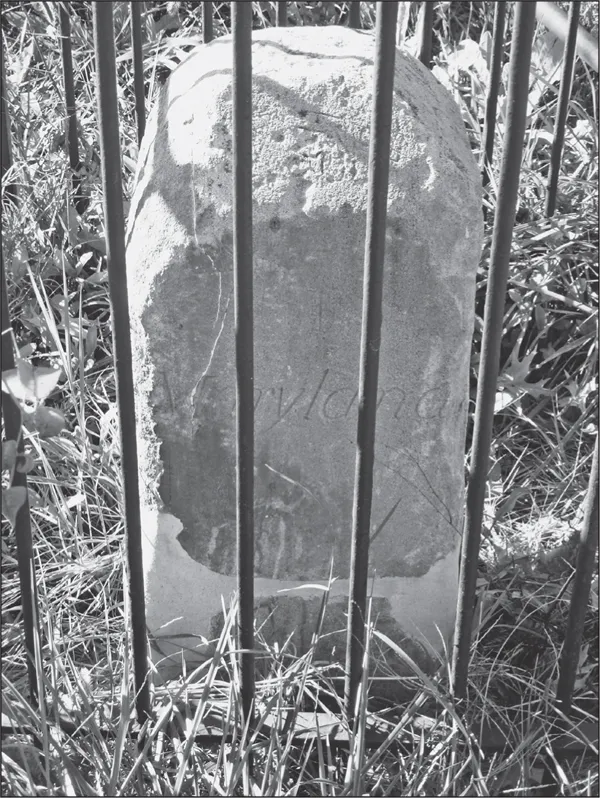
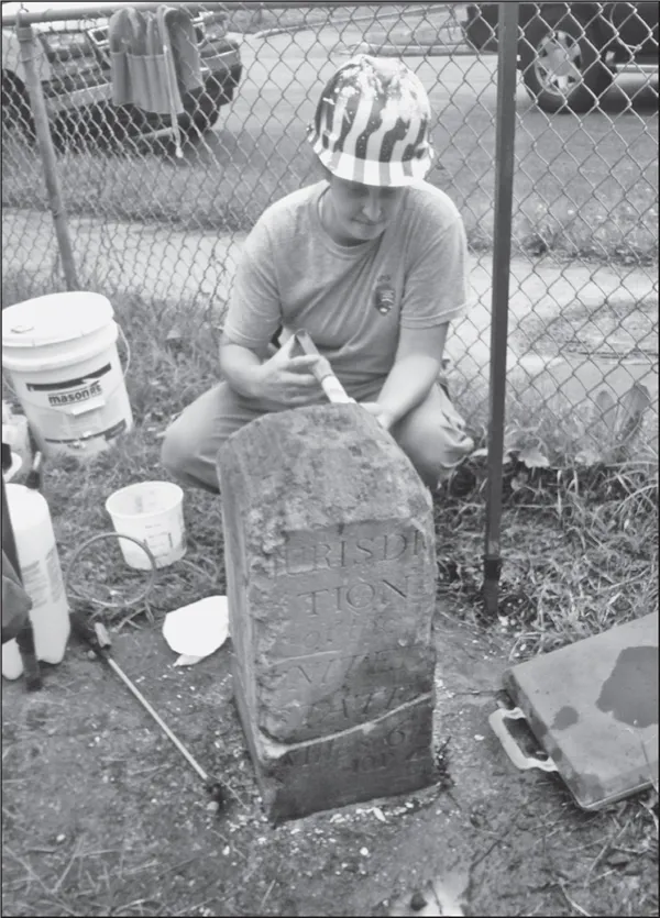
In 1792, the District of Columbia border was marked with stones made of Aquia Creek sandstone set at one-mile intervals. The stones, each of which has an identifying number, are the oldest federal monuments. Stone NE6 is located at the corner of Eastern Avenue and Thirty-fourth Street (right). Eastern Avenue did not, of course, exist in 1792, but when built, it was placed several feet inside the District boundary, meaning that the front yards of Eastern Avenue homes are partially in the District. On each stone, the side facing the District displays the inscription “Jurisdiction of the United States” and a mile number. Stone NE5 is located just north of Varnum Street on Eastern Avenue. The Daughters of the American Revolution installed protective iron fences around the stones in 1915. In 2012 (below), the National Park Service initiated a restoration effort. (Courtesy of Jimmy Tarlau.)
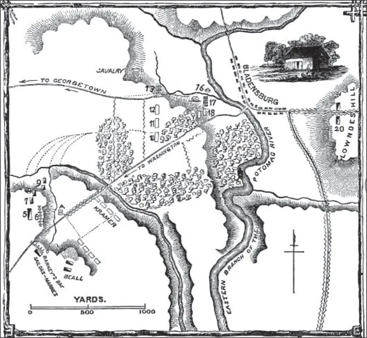
The Battle of Bladensburg took place August 24, 1814. Some American troops (numbers 5, 6, 7, 8, and 9 on the left edge of the map above, drawn in 1869 by Benson Lossing for his Pictorial Field-book of the War of 1812) were stationed along what today is Mount Rainier’s Newton Street, which runs along a defensible ridge above the headwaters of Dueling Creek (now diverted into a storm drain alongside Otis Street). Adm. Joshua Barney positioned his men in the middle of Bladensburg Road at the District of Columbia border. He was wounded, fell from his horse, and was taken to a nearby spring that became known as Barney’s Spring (seen below in a 1909 W.R. Ross photograph). Archeological research determined that the lost spring was south of Bladensburg Road just inside the District of Columbia. (Above, courtesy of Brian Knedler; below, courtesy of DC Public Library Special Collections.)
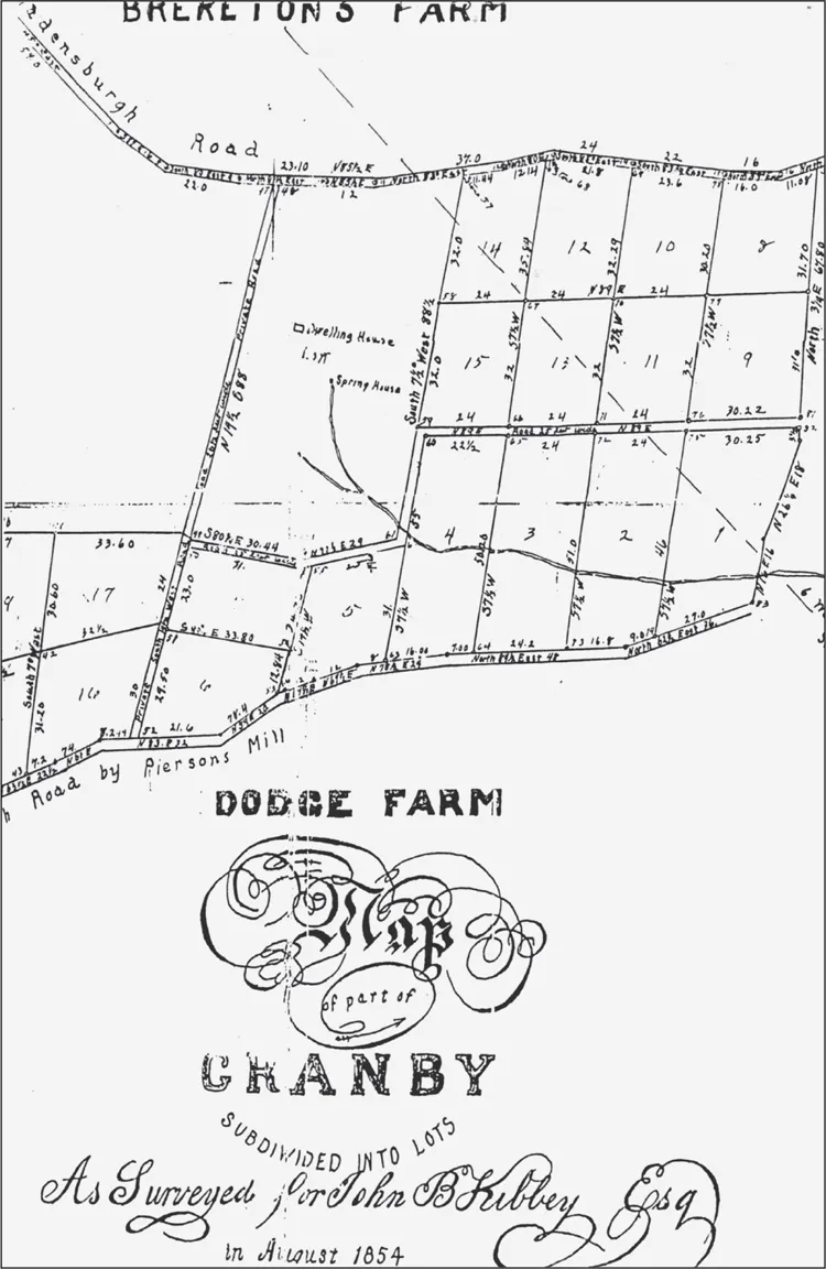
The 1853 survey of “Granby” places it both in the District of Columbia and in Maryland south of Bunker Hill Road. In 1927, St. Joseph’s Orphanage (below) was built on the hill just to the west of today’s Eastern Avenue, within what was the Granby tract. The Dodge Farm, south of Granby, belonged to Francis Dodge, a wealthy Georgetown resident engaged in shipping in the West Indies, who was an early land speculator in the area. Ten acres of his vast holdings were located in the southern part of present-day Mount Rainier. Originally, as on this survey, Bunker Hill Road was known as the “North Bladensburg Road” (later renamed after the Civil War–era fort in the District) to distinguish it from the Bladensburg Road that still exists today. (right, courtesy of M-NCPPC; below, courtesy of Bryan Knedler.)


In 1853, Thomas and Anna Clemson purchased 100 acres fronting on Bunker Hill Road. Anna’s father was Sen. John C. Calhoun. Their residence, “The Home,” seen in this c. 1856 watercolor, stood at the area’s highest point near Thirty-first and Shepherd Streets. Their farm was sold to developers in the 1890s and became the subdivision of Mount Rainier. Published correspondence between Anna and daughter Floride provides a glimpse of antebellum life, including accounts of their slaves, neighbors, and politics. They socialized with the Calverts at Riversdale and the Brookes in the District of Columbia (whose mansion still stands in the Brookland neighborhood). After the Civil War, the Clemsons returned to the South Carolina family estate that later became Clemson University. The Washington Post in 1890 described the long-abandoned farm: “The house is on a high hill and is surrounded by several acres of the largest forest trees in this section and was, and is today, one of the most beautiful places around Washington despite the rack and ruin the place is in.” (Courtesy of Fort Hill: Home of John C. Calhoun & Thomas G. Clemson, Clemson University.)
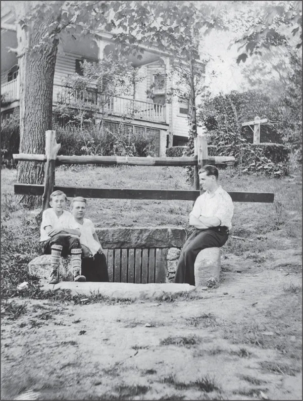
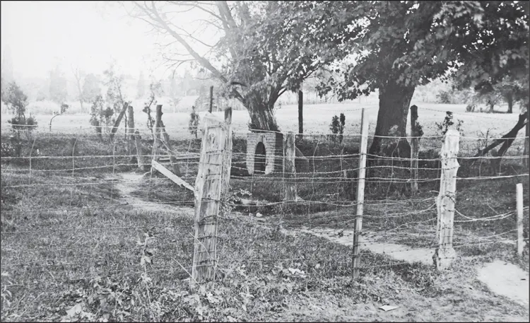
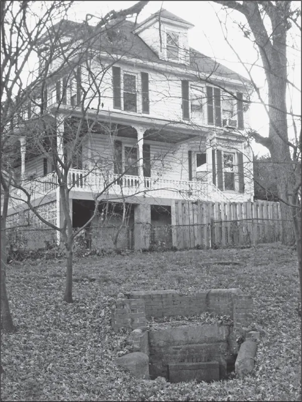
Homes clustered around the old spring at Shepherd and Thirty-third Streets used it to supply a small water system, but most homes at first depended on individual wells and outhouses. The origin of the brick and stone structure is lost to history, but the spring likely supplied the Clemson home in the 1850s and may have been the site of their bathhouse mentioned in letters. In 1917, bonds were issued and construction began on a town water system, but litigation slowed completion. In 1922, the system, including the springs and pumping station on Columbia Avenue (now Hamilton Street), was sold to the Washington Suburban Sanitary Commission. The Clemson spring was diverted into an underground storm drain system in 1947. The boys in the early photograph to the right are, from left to right, Norman Gill, Norman Venning, and Walter Pryor. (Right, courtesy of James R. Rice Jr.; below, courtesy of Jimmy Tarlau.)
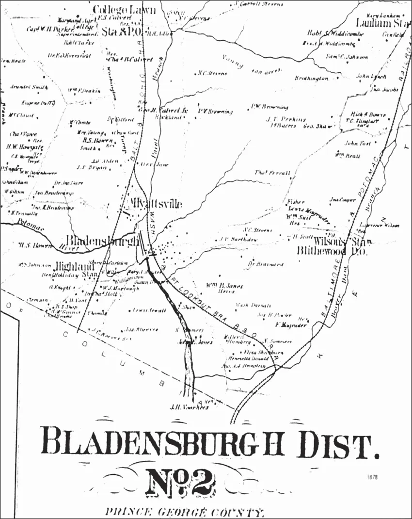
In the mid-19th century, the Mount Rainier area was included in the Bladensburg District. In this 1878 Griffith M. Hopkins map, the Baltimore & Ohio (B&O) Railroad slices through the middle of the map from College Lawn (now College Park) at the top to the bottom where it enters the District of Columbia. Present-day Mount Rainier is to the left of where the rail line enters the District to the left edge where Queens Chapel Road is visi...
Table of contents
- Cover Page
- Title Page
- Copyright Page
- Table of Contents
- Acknowledgments
- Introduction
- 1. A Streetcar Suburb’s Early Years
- 2. The Roaring Twenties and the Great Depression
- 3. World War II and the Baby Boom
- 4. Mid-Life Crisis
- 5. Debates and Decisions, New Direction
- 6. City on the Move
- Index
Frequently asked questions
Yes, you can cancel anytime from the Subscription tab in your account settings on the Perlego website. Your subscription will stay active until the end of your current billing period. Learn how to cancel your subscription
No, books cannot be downloaded as external files, such as PDFs, for use outside of Perlego. However, you can download books within the Perlego app for offline reading on mobile or tablet. Learn how to download books offline
Perlego offers two plans: Essential and Complete
- Essential is ideal for learners and professionals who enjoy exploring a wide range of subjects. Access the Essential Library with 800,000+ trusted titles and best-sellers across business, personal growth, and the humanities. Includes unlimited reading time and Standard Read Aloud voice.
- Complete: Perfect for advanced learners and researchers needing full, unrestricted access. Unlock 1.5M+ books across hundreds of subjects, including academic and specialized titles. The Complete Plan also includes advanced features like Premium Read Aloud and Research Assistant.
We are an online textbook subscription service, where you can get access to an entire online library for less than the price of a single book per month. With over 1.5 million books across 990+ topics, we’ve got you covered! Learn about our mission
Look out for the read-aloud symbol on your next book to see if you can listen to it. The read-aloud tool reads text aloud for you, highlighting the text as it is being read. You can pause it, speed it up and slow it down. Learn more about Read Aloud
Yes! You can use the Perlego app on both iOS and Android devices to read anytime, anywhere — even offline. Perfect for commutes or when you’re on the go.
Please note we cannot support devices running on iOS 13 and Android 7 or earlier. Learn more about using the app
Please note we cannot support devices running on iOS 13 and Android 7 or earlier. Learn more about using the app
Yes, you can access Mount Rainier by Bryan Knedler,Jimmy Tarlau in PDF and/or ePUB format, as well as other popular books in History & North American History. We have over 1.5 million books available in our catalogue for you to explore.