Occasional Paper No.2, Department of Anthropology, University of Manitoba.
- 166 pages
- English
- ePUB (mobile friendly)
- Available on iOS & Android
eBook - ePub
The Arctic Small Tool Tradition in Manitoba
About this book
Trusted by 375,005 students
Access to over 1.5 million titles for a fair monthly price.
Study more efficiently using our study tools.
Information
Subtopic
Native American StudiesIndex
Social SciencesChapter 1
The Thyazzi Site
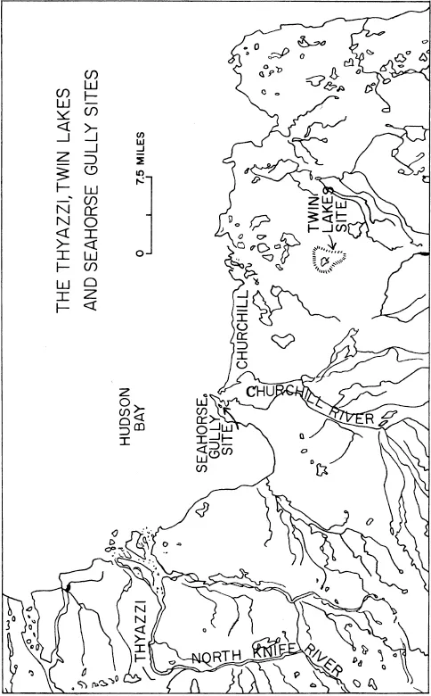
Figure 1. Site location map, northern Manitoba.
The Natural Setting
The Thyazzi site is situated in the northeastern corner of Manitoba, near the first large bend in the North Knife River (Fig. 1). Today it is about fifteen miles inland from the coast of Hudson Bay and just over thirty air miles northwest of Churchill, Manitoba.
In 1953, Dr. J. L. Giddings, accompanied by Mr. T. Jawbone, visited Thyazzi and made a surface collection of flint tools. The description and location of the site in Gidding’s article (1956a) is accurate except that the site is too far south on his sketch map of the Churchill region. Thyazzi was relocated by helicopter in 1965 with Mr. Jawbone again serving as guide. Part of the large bend in the North Knife River is shown in Fig. 2, 2 while one of the Chipewyan winter cabins, which Giddings mentioned as bordering the river, is shown in Fig. 2, 1.
The Thyazzi site is situated on a sandy ridge surrounded by a swamp and marsh low relief area of Pre-Cambrian bedrock and on the edge of an area classified physiographically as the Hudson Bay Lowland. The site is near the tree line and adjacent to the coastal-tundra zone. Surface deposits of marine and alluvial materials are overlain by podzolic and tundra soils supporting sporadic conifer stands.
Marine strand lines at this latitude extend sixty miles inland. Following the glacial retreat, uplift of the land left a series of beaches along the coast of Hudson Bay. The sandy ridge on which the site is located may be one of these beaches or an offshore bar (Fig. 3). The fact that the ridge is sloped sharply on only the eastern side and the fact that eskers are not abundant along the coast, indicates that the ridge is not a glacial feature; its structure and distance from the river indicates that it is not a river terrace. Probably at the time of its formation, there was a tidal flat where the North Knife River entered Hudson Bay.
In the aerial photograph (Fig. 3), the North Knife River occupies the lower right-hand corner, the larger Seal River the upper-left, while the streams in the upper right-hand corner drain into Hudson Bay which is off the photograph to the right. The oblique arrow points to the main occupation area of the site, the area visited by Giddings. The sandy ridge runs north and south, while just below the arrow is another, shorter ridge extending eastward at a right angle. This eastern extension of the site is five to ten feet lower in elevation. The vertical arrow which points approximately north, shows the southern extension to the site. The straight-backed series of lakes to the north of the site are the result of bedrock control. To the north and east of Thyazzi is a ridge 30.5 meters in elevation. It meets the midpoint of the tail of the oblique arrow.
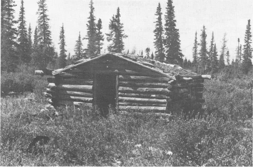
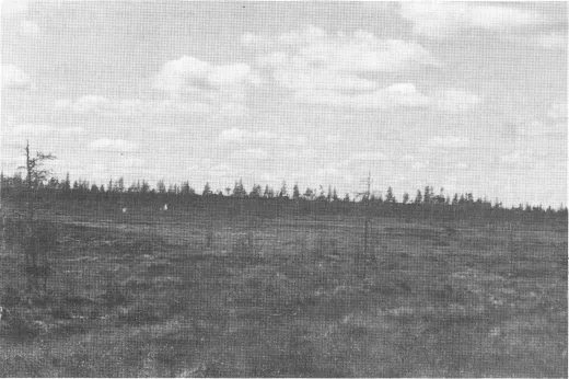
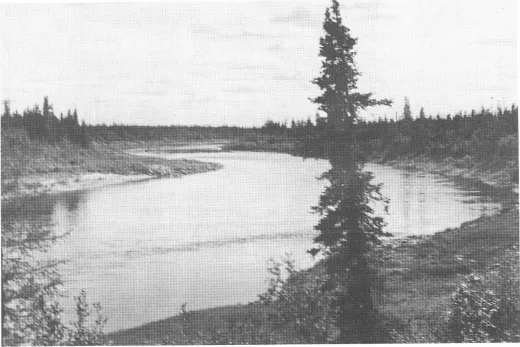
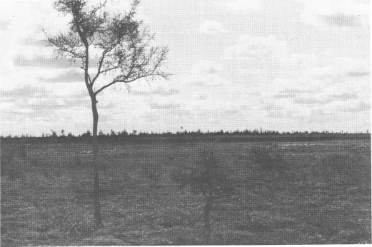
Figure 2. The North Knife River and Thyazzi.
1. (Upper) Chipewyan winter cabin on North Knife River.
3. (Lower) View of the Thyazzi ridge.
2. (Upper) The North Knife River near the Thyazzi site.
4. (Lower) The southern extension to the Thyazzi site.
Detailed topographic maps do not extend far enough west to include Thyazzi. Thyazzi is, however, west of the 30.5 meter ridge and the land rises to the west. The ridge is also higher than the river banks which, for most of their southward length, have an elevation of 30.5 meters. These factors, plus the height of the ridge (Fig. 4) and the known proximity of the 38 meter contour line on adjacent topographic maps, suggest that the elevation of the top of the Thyazzi ridge is 35 to 38 meters above sea level, with the eastern extension around two meters lower.
The Thyazzi ridge is less than a mile from the North Knife River and separated from it by a flat marshy plain. The cultural material is found on the ridge which rises for the most part five meters above the plain. A westward looking view of the ridge (Fig. 2, 3) also shows a white object below the ridge. This object, actually about two meters high, is part of a Chipewyan canvas tent used during winter caribou hunting in 1964. The University of Manitoba tent can be seen on top of the ridge. The general contours of the ridge, excluding the sourthern and eastern extensions, are shown on Fig. 4.
In 1965, two extensions to the site (Fig. 3) were discovered in forays made from the base camp on the main ridge. One extension protrudes eastward from the south end of Thyazzi proper. The bulk of the material on this subsidiary ridge was found on exposed gravelly areas 180 to 230 meters east of the south end of the main Thyazzi ridge. A few flakes were found still further east at the end of the ridge in an area of large sand blowouts. Compared with the main ridge, however, the eastern extension is more completely covered with moss and lichen. The area was probably never shown to Giddings, possibly because Mr. Jawbone had never collected artifacts there, but more likely because a Chipewyan graveyard is located at the eastern tip.
The southerly extension is about 900 meters south of the southern end of Thyazzi. This ridge runs roughly east-west and is somewhat weakly connected to the Thyazzi ridge. The ridge, which may be slightly higher than that of Thyazzi, has a fine gravel and heavy moss covering which, however, yielded a few artifacts in exposed areas. The ridge, seen from the nearby lake to the north (Fig. 2, 4), continues to meander to the north and west where additional material may yet be found. As at Thyazzi, there were numerous recent brush shelters and evidences of caribou hunting.
The main part of Thyazzi is characterized by sand and gravel blowouts, possibly the result of moss removal due to the trampling of caribou. The artifacts are distributed on the ridge for 600 meters north and south and 50 or more meters east and west. West of the blowout areas there is muskeg and beyond this is a lake about 540 meters long. The east end of the ridge is lined with spruce trees, which as Giddings (1956a: 258) has noted, are often slow-growing and gnarled, unlike the same types bordering the river. Two granite boulder fields cut across the site, the smaller one at about 275 meters south of the north end and the larger about 100 meters further to the south (Fig. 5, 1). These boulder fields may have been advantageous to the hunter in slowing the caribou in their movement along the high ground. Generally, the ridge rises...
Table of contents
- Cover
- Title Page
- Copyright Page
- Acknowledgments
- Contents
- Tables
- Figures
- Introduction
- Chapter 1 The Thyazzi Site
- Chapter 2 The Twin Lakes Site
- Chapter 3 The Seahorse Gully Site
- Chapter 4 Thyazzi,Twin Lakes and Seahorse Gully in the Circumpolar World
- Statement of Problems
- References
Frequently asked questions
Yes, you can cancel anytime from the Subscription tab in your account settings on the Perlego website. Your subscription will stay active until the end of your current billing period. Learn how to cancel your subscription
No, books cannot be downloaded as external files, such as PDFs, for use outside of Perlego. However, you can download books within the Perlego app for offline reading on mobile or tablet. Learn how to download books offline
Perlego offers two plans: Essential and Complete
- Essential is ideal for learners and professionals who enjoy exploring a wide range of subjects. Access the Essential Library with 800,000+ trusted titles and best-sellers across business, personal growth, and the humanities. Includes unlimited reading time and Standard Read Aloud voice.
- Complete: Perfect for advanced learners and researchers needing full, unrestricted access. Unlock 1.5M+ books across hundreds of subjects, including academic and specialized titles. The Complete Plan also includes advanced features like Premium Read Aloud and Research Assistant.
We are an online textbook subscription service, where you can get access to an entire online library for less than the price of a single book per month. With over 1.5 million books across 990+ topics, we’ve got you covered! Learn about our mission
Look out for the read-aloud symbol on your next book to see if you can listen to it. The read-aloud tool reads text aloud for you, highlighting the text as it is being read. You can pause it, speed it up and slow it down. Learn more about Read Aloud
Yes! You can use the Perlego app on both iOS and Android devices to read anytime, anywhere — even offline. Perfect for commutes or when you’re on the go.
Please note we cannot support devices running on iOS 13 and Android 7 or earlier. Learn more about using the app
Please note we cannot support devices running on iOS 13 and Android 7 or earlier. Learn more about using the app
Yes, you can access The Arctic Small Tool Tradition in Manitoba by Ronald J. Nash in PDF and/or ePUB format, as well as other popular books in Social Sciences & Native American Studies. We have over 1.5 million books available in our catalogue for you to explore.