The Till-Tweed river catchment areas in Northumberland contain outstanding archaeological and palaeoenvironmental remains which have been in general only poorly understood. This study has assembled detailed data that will provide a platform for future landscape-based research and site-based investigation. Written from a landscape, or geoarchaeological perspective, this study develops a methodology and management tool that will allow planners, curators and developers working in the region to to easily access information across sectors, and provide a transparent and easily comprehended record of sensitive archaeological and palaeoenvironmental sites.
eBook - ePub
Managing Archaeological Landscapes in Northumberland
Till Tweed Studies Volume 1
- 416 pages
- English
- ePUB (mobile friendly)
- Available on iOS & Android
eBook - ePub
Managing Archaeological Landscapes in Northumberland
Till Tweed Studies Volume 1
About this book
Trusted by 375,005 students
Access to over 1.5 million titles for a fair monthly price.
Study more efficiently using our study tools.
Information
Subtopic
ArchaeologyIndex
Social Sciences1 INTRODUCTION
Here is abundant business for an antiquary; every place shows you ruined castles, Roman altars, inscriptions, monuments of battles, of heroes killed, and armies routed…
(Defoe 1726, describing Northumberland in his travelogue ‘A Tour Through the Whole Island of Great Britain’)
SETTING THE SCENE
Managing archaeological remains presents an ongoing challenge for curators given the almost infinite diversity of deposits and their condition of preservation. In recent years the shortcomings of protecting individual sites, usually through a combination of designation and management agreements, has become apparent as many sites survive within what can be better understood as archaeological landscapes. Devising practical methods for the day to day management of landscapes that are considered archaeologically sensitive requires an approach that attempts to reconcile the unknown potential of discrete landscape areas with established records from similar landscape settings. Accordingly, the starting point for this study has been the recognition of the need for: 1) a ‘landscape’ scale approach to underpin management and decision making, and 2) an explicit and systematic way of partitioning the landscape according to archaeological potential. As the survival of all archaeological and palaeoenvironmental remains is ultimately dependent on geoarchaeological circumstances (e.g. Renfrew 1976; Butzer 1982; Waters 1992) it follows that by understanding the landscape as a patchwork of landform elements, each with its own distinctive geological, geomorphological, archaeological and palaeoenvironmental associations, a map-based characterisation of a given landscape can be constructed. In this study we have applied this approach to an area in North-East England and have classified a suite of landform elements that correspond to the age and character of the region’s landscape. However, the general approach can be applied to any other region subject to acquiring an appropriate understanding of the geomorphology and archaeological resource specific to that area. It is hoped, therefore, that this study will serve as an illustration of an approach to archaeological landscape management that might usefully inform practice in other regions of the UK and beyond.
This volume, the first of two, presents the results of over a decade of geoarchaeological investigation by the two authors in north Northumberland, an area with outstanding archaeological remains but in a remote and somewhat neglected region abutting the Anglo-Scottish border. The work has been primarily funded by English Heritage in recognition of the sensitivity of the archaeological landscape to development pressures and the pressing need for a coherent management framework. Originally established as ‘The Milfield Basin Geoarchaeology Project’, the research was subsequently expanded to include a second ‘Till-Tweed Geoarchaeology Project’ and has drawn together data sets from a programme of research including fieldwalking, test pitting, evaluation trenching, aerial photographic interpretation, landform mapping, sediment coring and palaeoenvironmental analysis. In combination these investigations facilitate a multi-disciplinary analysis of the development of Late Quaternary landscapes and their archaeological associations in the valleys of the Till (known as the Breamish in its upper reaches), and lower Tweed, a continuous valley reach that extends from the uplands of the Cheviot massif to the North Sea coast at Berwick (Fig. 1.1). River valleys in this region appear to have provided foci for prehistoric and early historic communities since the arrival of the first hunter-gatherers, and the overarching geoarchaeological context of the research is intended to provide a conceptually sound basis for understanding landscape development, land use and settlement across north Northumberland from hill to coast. This theme will be developed in much greater detail in the second volume arising from the work (Passmore and Waddington in prep); the focus of this volume is the presentation of the project methodology, data and the development of a practical management framework for the Till-Tweed archaeological landscape.
The study area encompasses the valleys of the lower Tweed from Coldstream to Berwick, and the tributary valley of the Till from its confluence with the Tweed at Tweedmill upstream to Ingram (Fig. 1.2). The area of the Milfield Basin, in the middle reaches of the Till valley, has provided a key focus for agricultural production, settlement, strategic strongholds, centres of political power and historic battles. The area forms a large expanse of floodplain and upstanding sand and gravel terraces that are encircled by the steeply rising Cheviot Hills and Fell Sandstone escarpments. The fertile lands of the valley floor have been dubbed the ‘breadbasket’ of Northumberland as they provide a wide expanse of productive farmland that enjoys the effects of a warmer and drier microclimate than adjacent areas (Payton 1980).
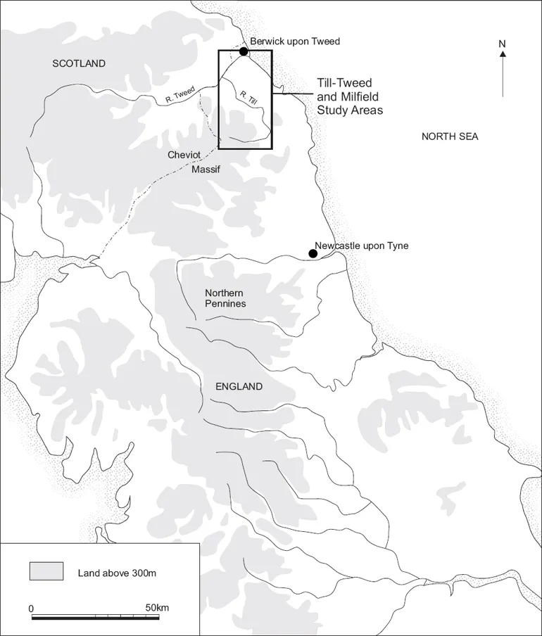
Fig. 1.1. Location of the Till-Tweed study area in North-East England.
Northumberland has become increasingly well known for its wealth of archaeological remains dating from the Mesolithic through to the medieval period (e.g. Harding 1981; Frodsham 2004; Hope-Taylor 1977; Miket 1981; 1985; Waddington 1999; 2007; Waddington and Passmore 2004), with many of these sites considered to be of national and international importance. The valley floor areas of the Till and Tweed form the largest sand and gravel deposits in North-East England and it is these free-draining and fertile surfaces, situated above the floodplains of the rivers, that contain the bulk of the known archaeological sites (Waddington 1999; Passmore et al. 2002) and most of the scheduled monuments.
Fig. 1.2. The Till-Tweed study area.
At the heart of the project is a landscape perspective that has focused on the characterisation of landforms and their archaeological associations. By using landforms to drive the fieldwork strategy (see below) and the mapping of archaeological remains, characterisation of the landscape takes place in relation to topographic features that have corresponding geological, soil, drainage and vegetation characteristics. This approach assumes that most human land use over the past 10,000 or so years is related to such features. Over the longue durée prior to the industrial revolution this is almost certainly the case, but it assumes a certain degree of environmental determinism as it is predicated on the view that human use of landscape is to some extent a response to landscape configuration. Nevertheless, this approach allows a consistent framework to be developed that can characterise large areas over long time spans. It also recognises, and allows for, variation in the distribution of soil types, drainage, vegetation, raw materials and land suitable for settlement or other uses. While it is acknowledged that social, political and economic considerations will have exerted important influences on past patterns of human settlement and land use, this approach considers the landscape itself, comprising the landforms, soils and vegetation cover, to form the basis for understanding the geographic context of human behaviour through time. Linking the past use of the physical landscape into the social, political, economic and ideological arenas of human behaviour provides an avenue into understanding past human groups, particularly in relation to observations based on geographical patterning of the data and increasingly accurate chronological control.
An important outcome of this approach is that characterising the landscape in this way allows modern landscape management, planning and development to be explicitly assessed according to their impact on different landforms. With each landform category having associations with particular types of archaeological and palaeoenvironmental sites, conditions of preservation and sensitivity to different evaluation techniques, the potential impacts on the archaeological and palaeoenvironmental resource can be gauged and appropriate evaluation and mitigation measures employed (see Chapters 6 and 7).
PROJECT BACKGROUND
Currently the sand and gravel deposits of the Till-Tweed catchment are subject to large-scale gravel extraction (e.g. Cheviot Quarry, Lanton Quarry, Hedgeley Quarry, Brandon Quarry and Wooperton Quarry) and there are applications in hand for new quarries at a number of sites including Brandon West, Hedgeley Haugh, Mains Hill and Marleyknowe (Northumberland Minerals Local Plan; Draft 1996). Ongoing, planned and potential aggregate extraction in the Till-Tweed catchment presents, therefore, a potential threat to the archaeological and palaeo environmental record developed on, and potentially buried within and beneath, catchment sand and gravel deposits. This threat is particularly acute in the Hedgeley Basin and Milfield Basin, where glaciofluvial and fluvial gravel terraces constitute the single most important landform type in the North-East region for archaeological remains, including the nationally important sites of Yeavering, Maelmin, and the Milfield henge complex. However, with the exception of work conducted in the Milfield Basin (Passmore et al. 2002), the landform, sediment and archaeological associations in catchment valley floors were until now poorly understood.
There has therefore been a pressing need to assess the nature and extent of the archaeological and palaeoenvironmental resource across these areas and to provide a management framework for inclusion in the Local Development Framework which can then be used by archaeological curators, planning officers, developers and the Northumberland Sites and Monuments Record, hereafter referred to as the Historic Environment Record or HER. Furthermore, the wealth of archaeological and palaeoenvironmental information from the sand and gravel deposits of the study area has seldom been made widely accessible to the general public. This is because much previous research work has remained confined to academic publications (e.g. Yeavering, the Milfield henges, Thirlings etc.), and there has been little attempt to coordinate and disseminate research findings to the wider non-academic community. Accordingly, a further component of this study has been the production of a series of popular books (e.g. Waddington and Passmore 2004) and the enhancement of interpretation facilities and the visitor experience at the Maelmin Heritage Trail in Milfield village (Waddington 2004a; www.maelmin.org.uk). This important strand of work lies beyond the scope of this volume but aspects of the wider outreach activity have been covered in other publications and reports (e.g. Waddington 2004a; Johnson and Waddington in press).
AIMS AND OBJECTIVES OF THE PROJECT
The broad aims of the project were supported by a suite of objectives that were refined and developed as the project evolved over several years. Although ambitious in the first instance, the emergence of early project outcomes and the availability of further resources led to an expansion of the geographical scope of the project as well as an enhancement of the management guidance provision.
Aims
1. | Establish the spatial extent and character of landscapes associated with glaciation and deglaciation (including ice-contact meltwater deposits) and glaciofluvial sand and gravel terraces on the valley floor of the Till-Tweed study area. |
2. | Establish the spatial extent, character and, where possible, the chronology of Holocene landforms and sedimentary sequences within the study area. |
3. | Identify and evaluate the extent and preservation of deposits of palaeoenvironmental and archaeological value developed on glacial and post-glacial landscapes within the study area. |
4. | Enhance the understanding of past human land use and settlement in the study area through analysis of aerial photographs and a programme of archaeological fieldwalking, limited excavation and test pitting. |
5. | Develop an archaeological evaluation and management guidance framework for the Till-Tweed study area. |
Specific Objectives
1. | Undertake geomorphological mapping and (where possible) dating of Late Pleistocene and Holocene landforms throughout the study area. This was intended to differentiate valley floor landscapes into spatially delimited ‘landform elements’ that share similar geomorphic and topographic characteristics (cf. Passmore et al. 2002). Experience in the Milfield Basin and elsewhere in northern England (Passmore et al. 2002; Passmore and Macklin 1997) suggested that valley floor landform and sediment assemblages were most likely to be classified on the basis of their mode of formation as ice-contact meltwater deposits and glaciodeltaic, glaciofluvial or Holocene fluvial terraces. Smaller features associated with these landform elements, where evident as enclosed or channelled depressions (e.g. palaeochannels and kettle holes), were also differentiated, given their potential to act as foci for organic-rich sediment over Holocene timescales. |
2. | Assess organic-rich sedimentary sequences identified during the project for their potential to yield radiocarbon dates and palaeoecological records of vegetation and land use changes. |
3. | Conduct a high-resolution archaeological survey (using a combination of aerial photograph transcription and fieldwalking) of lithic scatters and monuments across landform elements identified by Objective 1. This was intended to extend the knowledge base gained from previous archaeological work in the Milfield Basin into hitherto unsurveyed areas, and thereby augment research priorities set out in the North-East Regional Research Framework (Petts and Gerrard 2006). It also responded to needs identified in national research frameworks such as ‘Exploring Our Past’ (3rd Draft, http://www.english-heritage.org.uk/upload/pdf/bericht4.pdf). |
4. | Assess the extent of past human activity across Till-Tweed landscapes through time in order to allow predictive modelling of the potential range and character of archaeological and palaeoenvironmental deposits liable to be encountered prior to new aggregate extraction proposals. This combined ... |
Table of contents
- Cover
- Title Page
- Copyright
- Dedication
- Contents
- List of Figures
- List of Tables
- Acknowledgements
- Summary
- Résumé
- Zuasammenfassung
- Samenvatting
- Sammenfatning
- Chapter 1: Introduction
- Chapter 2: Past and Present Landscapes in the Till-Tweed Region
- Chapter 3: The Stone Age Landscape: Fieldwalking and Test Pits
- Chapter 4: Monuments in the Landscape: the Aerial Photographic Resource
- Chapter 5: Uncovering the Past: Evaluation Trenching of Cropmark Sites
- Chapter 6: Managing the Historic Environment
- Chapter 7: The Landform Element Approach in Practice: Case Studies from the Till and Tweed
- Appendices
- References
- Index
Frequently asked questions
Yes, you can cancel anytime from the Subscription tab in your account settings on the Perlego website. Your subscription will stay active until the end of your current billing period. Learn how to cancel your subscription
No, books cannot be downloaded as external files, such as PDFs, for use outside of Perlego. However, you can download books within the Perlego app for offline reading on mobile or tablet. Learn how to download books offline
Perlego offers two plans: Essential and Complete
- Essential is ideal for learners and professionals who enjoy exploring a wide range of subjects. Access the Essential Library with 800,000+ trusted titles and best-sellers across business, personal growth, and the humanities. Includes unlimited reading time and Standard Read Aloud voice.
- Complete: Perfect for advanced learners and researchers needing full, unrestricted access. Unlock 1.5M+ books across hundreds of subjects, including academic and specialized titles. The Complete Plan also includes advanced features like Premium Read Aloud and Research Assistant.
We are an online textbook subscription service, where you can get access to an entire online library for less than the price of a single book per month. With over 1.5 million books across 990+ topics, we’ve got you covered! Learn about our mission
Look out for the read-aloud symbol on your next book to see if you can listen to it. The read-aloud tool reads text aloud for you, highlighting the text as it is being read. You can pause it, speed it up and slow it down. Learn more about Read Aloud
Yes! You can use the Perlego app on both iOS and Android devices to read anytime, anywhere — even offline. Perfect for commutes or when you’re on the go.
Please note we cannot support devices running on iOS 13 and Android 7 or earlier. Learn more about using the app
Please note we cannot support devices running on iOS 13 and Android 7 or earlier. Learn more about using the app
Yes, you can access Managing Archaeological Landscapes in Northumberland by D. G. Passmore, Clive Waddington in PDF and/or ePUB format, as well as other popular books in Social Sciences & Archaeology. We have over 1.5 million books available in our catalogue for you to explore.