The fall of the Soviet Union was a transformative event for the national political economies of Eastern Europe, leading not only to new regimes of ownership and development but to dramatic changes in the natural world itself. This painstakingly researched volume focuses on the emblematic case of postsocialist Romania, in which the transition from collectivization to privatization profoundly reshaped the nation's forests, farmlands, and rivers. From bureaucrats abetting illegal deforestation to peasants opposing government agricultural policies, it reveals the social and political mechanisms by which neoliberalism was introduced into the Romanian landscape.
Two Centuries of Ecological and Socio-economic Transformations
‘The fight between man and nature, the desperate efforts to grab from the land a morsel of food, all these are of Homeric proportions.’ —G. Bogza, Ţări de piatră, de foc şi de pământ (Countries of Stone, Fire, and Earth)
When the bus turned right off the main road that links Piteşti, the Argeş county capital, to the northern part of the county, a rural landscape opened up before my eyes: a hilly village crossed by a small but still lively river, with small patches of orchards and pasture on the left side of the road and agricultural fields on the right. Patches of forest alternating with plots of deforested land still covered the peak of the hill. The bus had to make a slalom between the deep holes in the asphalt which looked ‘like it had been bombed’ as my host described it a few hours after my arrival in the commune. The state of the road, which links Dragomireşti commune to the city capital Piteşti, located 26 kilometres away, transformed travel to and from the commune into an adventure.1 When I arrived in Dragomireşti I was still able to see the signs of what used to be a region famous for its very fine orchards. The contrast between green, healthy trees and the shrivelled trees now standing in the orchards along the road was a sign that the local economy no longer puts the same value on its fruit trees.
This chapter is intended to guide the reader through the history of land use and of the local economy in Dragova and Dragomireşti, the two communes from Walachia where I carried out fieldwork in 2004.2 It sets the scene of the whole book by moving back and forth through time from the early nineteenth century to our times in order to describe the changes in the landscape. I have other reasons for conducting the reader through two centuries of local history: one is that I link changes in the agrarian landscape to the political and economic changes, showing their close interdependency. Another reason is to show that agriculture and forestry in the area were part of a national economy beginning in the nineteenth century. The rise of the socialist state, land collectivization and forest nationalization did not disrupt connections between the local economy of Dragomireşti and the national and international markets. As I will show in the second part of this chapter, socialism only changed the forms and conditions of those connections to the national economy. As for Dragova, the location of the commune at the border between Walachia and Transylvania transforms it into a place of passage for people and goods. Besides, the natural scenery, spectacular forests and caves scattered throughout the area made it ideal for rural tourism, one of the pursuits that have radically transformed the local landscape.3
Dragomireşti, a Hilly Commune
Today, Dragomireşti commune comprises three villages and numbers 2,852 people. Vâlceni and Costeşti are located along the river Argeşelu on the surrounding terraces while Dragomireşti, the administrative centre of the commune, lies along the 733 County Road. The commune comprises three ethnic groups: 933 Romanians, who represent the ethnic majority, 593 Roma people (ţigani) and Rudari, and 99 persons belonging to other ethnic groups.4 Out of 593 people designated as Roma, around 300 are Rudari. Roma people are designated under the generic term ţigani lăutari (Roma fiddlers).
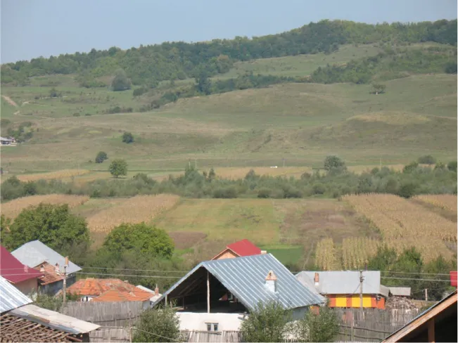
On ascending one of the surrounding hills one can see the landscape of the commune. The commune has 4,181 hectares. The plain along the river, 405 hectares, is the crop field. Villagers grow cereals, mostly maize and some wheat, potatoes and vegetables, all for subsistence purposes, on highly fragmented cropland. The cropland is segmented into narrow long strips of around 12 metres in width and as long as 2 kilometres. The strips cross the river and extend up the hills. This is a clear sign of the lack of any agricultural association and shows that individuals work the crop fields.
The county road that links Mioveni, a small town of slightly more than 30,000 inhabitants, to the communes along Argeşelu River divides the inhabited area into two parts. Dragomireşti village developed mostly along this road. Most of the households in Dragomireşti village have large backyards, some of the villagers owning up to one hectare of land of mixed cultivation. The orchards, totalling 208 hectares, grow in the middle of the pastures. Small gardens are planted next to the house. Tomatoes, onions, garlic, red and green peppers, carrots, cabbage and parsley all come from these small gardens and consumed by villagers. At the end of the pasture begins the 2,553 hectares of forest. The hill peaks, once covered by forests, look like a patchwork: the dense forest is interspersed with large deforested areas.
Most of the 698 hectares of pastures and meadows lie outside the inhabited area. Here the eye is met with the same patchwork as rather large areas of the pastures are covered with newly constructed houses. Bushes advance year by year as outposts of the forest. Cows, no more than a few dozen, graze among the bushes.
Illustration 1.1. The Fragmented Landscape in Dragomireşti
Not all households have large backyards. If the spectator turns her eyes to the southeast or northeast she will notice that most households in Costeşti and Vâlceni have rather small backyards packed in next to each other. Both villages lie on the hillside, on the eastern side of the river, and sometimes the small backyards are packed very close to one another on the slope of the hills. This contrast has its origin in pre-socialist times. Today, people from Dragomireşti village proudly emphasize their origins as free landholders (moşneni) while with a slight irony sparkling in their eyes they call villagers from Vâlceni and Costeşti clăcaşi (serfs). Most of the former clăcaşi are rather poor, Dragomireştens claim, as they never had much land or forest. In retaliation, inhabitants of these two villages are ready to say to any stranger that ‘people in Dragomireşti are conceited and even lazy’, as even though they have enough land and forest they still complain about the harshness of life.
The hilly region is suitable for the forest, natural pastures and the growing of fruit trees. Small creeks, dry for most of the year, cross the surrounding hills creating terraces suitable for fruit trees. The hills protect the village and the long strips of cropland along the river from powerful winds. The climate is temperate with no long droughts, blizzards or long wet periods. The soil constituting the flood plain was created by alluvial deposit and is well-suited to growing crops. The slopes of the surrounding hills are made of layers of clay, sand and gravel. These are not suitable for anything else but pasture. The peaks of the hills are covered with forest. The most common trees are oak (Quercus robur), beech (Fagus), hornbeam (Carpinus betulus), maple (Acer platanoides), elm (Ulmus), birch (Betula) and sycamore maple (Acer pseudoplatanus).
Free Small Landholders, Serfs and Land Use Practices
To some extent the area’s patchy landscape and social stereotypes originate in its local history. There are few documents older than 1838 describing the village’s economy and social relations in sufficient detail.5 Until 1857, the agricultural land belonging to Dragomireşti village was collectively owned by 76 of the 130 families living in the village at that time. The other 54 landless families received small plots through the agrarian reform in 1864.6 Beginning in 1857 the collective land was shared among three ancestors (moşi), representing the first settlers and founders of the village. All native families are descended from these three ancestors. Further, the families that had the same ancestor shared the land in long narrow strips called chingi (meaning ‘belt’ in Romanian). There was logic in having such long strips as they covered several sorts of land: cropland for cereals, hemp and flax, lower slopes for orchards and pasture and forest at the top of the hill. In this way, every family was able to obtain all types of agricultural products ranging from cereals, especially maize, to fruits, mostly plums, and hay. An area of forest as great as 574 hectares was also owned collectively until 1948, when the socialist state nationalized it.7
In the same period, Costeşti – including 86 families of serfs and 37 Roma slaves (ţigani robi) – belonged to a nobleman.8 The serfs were living on the nobleman’s land and they had to deliver taxes both to the state (king) and to the nobleman. They also worked their master’s land. The numbers illustrate the villagers’ poverty: the 482 inhabitants, counting both serfs and slaves, were living in 63 huts, 23 of which were constructed underground (bordeie). They worked some 430 hectares of land and the orchards counted 6,110 fruit trees and 23 mulberry trees. The main crops cultivated were hemp, flax, maize, wheat and grape. These families received between 2.5 hectares and 1.5 hectares of agricultural land through the 1864 land reform.
In 1838 Vâlceni was a mixed village composed of serfs, free landholders and one nobleman. The 67 families worked 150 hectares of land, had 13 hives and, important to the local economy and that of the other two villages, 2,910 plum trees. The nobleman’s land measured 1,560 hectares of cropland, pastures and orchards.
In 1864, Ioan Alexandru Cuza’s land reform, the first important land reform in the Romanian history, granted land to peasants based on their agricultural inventory (the number of oxen and cows). Those who owned four oxen and a cow received five hectares in Walachia and seven hectares in Moldavia. Those with two oxen and one cow received three hectares in Walachia and five in Moldavia. Finally, villagers with no agricultural inventory received two hectares in Walachia and three in Moldavia. Peasants had to pay a certain amount of money for the land they received which was finally borrowed by the state. They had to pay back their debt in maximum 30 years. Noblemen who lost the control of up to two thirds of the arable land – although they had the right to choose the best quality land they kept – received financial compensation.9
Not only serfs benefitted from the 1864 land reform but the villages too. From the nobleman’s land Costeşti village received 48 hectares of pasture, which had to be used communally by the inhabitants (called islaz). Further, the village was rewarded with another 144 hectares of pasture through the 1921 land reform, to be used communally by villagers. Dragomireşti village received 48 hectares of communal pasture in 1921 only.10 The communal pasture was very useful as in the second part of the nineteenth century the number of animals in the three villages grew significantly. In 1838 the 320 families from the three villages owned 1,810 head of cattle (cows, oxen for work, sheep, goats and horses). By 1890 the three villages counted 2,093 head of cattle. It is true that there was also a population explosion, with 2,252 families recorded at the end of the century.11 While the number of sheep decreased significantly from 444 to 87, the number of cows grew from 295 in 1838 to 601 heads in 1890. A possible explanation for the growing number of cattle is the land reform and the new communal pastures at the villagers’ disposal. After 1864 it was easier for a family to keep a cow, having gained the right to graze their animal on the communal pasture. Besides, it was economically more viable to have cows, which give milk almost all year round, rather than sheep, which give milk for around five months in a year.
However, there were other changes in land use that were maybe more important than this one. In 1838 there were 547 draft animals (oxen and horses) while in 1890 the number increased to 730.12 This is the sign of change in the local economy. Agriculture most probably brought some economic advantages. The local fairs, the place where people from neighbouring villages gathered to buy and sell their agricultural produce, dated from this period. Local memories of the mixture of fun – gypsy musicians playing different instruments, members of families scattered throughout the region meeting up – and commercial activities are still vivid. However, a new activity seemed to be more lucrative than agriculture and this was the exploitation of forest. This new ...
Table of contents
Cover Page
Title Page
Copyright Page
Contents
List of Illustrations
List of Figures
Preface
List of Abbreviations
Introduction. Privatizing the State and the Transformation of the Agrarian Landscape
Chapter 1. Dragomireşti and Dragova: Two Centuries of Ecological and Socio-economic Transformations
Chapter 2. Postsocialism as Neoliberalism: Reorganizing Society and Nature
Yes, you can cancel anytime from the Subscription tab in your account settings on the Perlego website. Your subscription will stay active until the end of your current billing period. Learn how to cancel your subscription
No, books cannot be downloaded as external files, such as PDFs, for use outside of Perlego. However, you can download books within the Perlego app for offline reading on mobile or tablet. Learn how to download books offline
Perlego offers two plans: Essential and Complete
Essential is ideal for learners and professionals who enjoy exploring a wide range of subjects. Access the Essential Library with 800,000+ trusted titles and best-sellers across business, personal growth, and the humanities. Includes unlimited reading time and Standard Read Aloud voice.
Complete: Perfect for advanced learners and researchers needing full, unrestricted access. Unlock 1.4M+ books across hundreds of subjects, including academic and specialized titles. The Complete Plan also includes advanced features like Premium Read Aloud and Research Assistant.
Both plans are available with monthly, semester, or annual billing cycles.
We are an online textbook subscription service, where you can get access to an entire online library for less than the price of a single book per month. With over 1 million books across 990+ topics, we’ve got you covered! Learn about our mission
Look out for the read-aloud symbol on your next book to see if you can listen to it. The read-aloud tool reads text aloud for you, highlighting the text as it is being read. You can pause it, speed it up and slow it down. Learn more about Read Aloud
Yes! You can use the Perlego app on both iOS and Android devices to read anytime, anywhere — even offline. Perfect for commutes or when you’re on the go. Please note we cannot support devices running on iOS 13 and Android 7 or earlier. Learn more about using the app
Yes, you can access Disrupted Landscapes by Stefan Dorondel in PDF and/or ePUB format, as well as other popular books in Economics & Environmental Economics. We have over one million books available in our catalogue for you to explore.