THE PRE-PATRIARCHAL PERIOD
Garden of Eden (Genesis 1–3)
The book of Genesis, using terse yet picturesque language, recounts the history of the world from the time of creation until Jacob’s journey into Egypt. The second section of the creation account (Gen 2:4–25) focuses on the creation of the first humans, who were placed in a perfect environment called the garden of Eden.
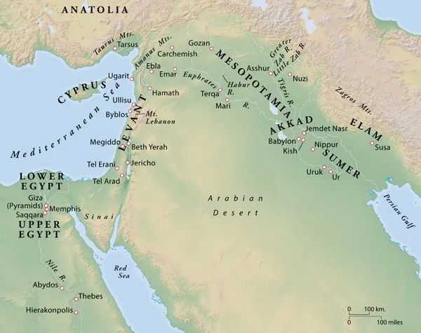
The name Eden in Hebrew means “delight.” Some scholars have suggested that Eden is related to the Sumerian/Akkadian word edin(u), meaning “plain,” and that this is a description of the location of Eden. It seems that Eden was the name of a locality, and the special garden planted in the eastern portion of it (Gen 2:8) is described as containing trees and an abundance of water. We can infer that it was in a warm climate—note the mention of fig trees and the lack of clothing (3:7). The major river that watered Eden separated into four headwaters, called Pishon, Gihon, Tigris, and Euphrates (2:10–14). The latter two rivers are well known, but the identities of the first two are not.
One view places Eden in eastern Turkey near the headwaters of the Tigris and the Euphrates. If this is correct, then the Pishon and the Gihon might be identified with the Araxes and Murat Rivers. Another view places Eden in southern Iraq. It has the advantage of placing the garden in a warmer climate in the vicinity of the two identifiable rivers, the Tigris and the Euphrates. The Pishon and the Gihon could then have been tributaries of the Tigris and/or Euphrates or canals that branched off these rivers.
The identification of Havilah and Cush (Gen 2:11–13) is difficult. “Havilah” may have been a region located in Sinai and/or Arabia (25:18), a locality in which there were supplies of gold, aromatic resins, and onyx. The “land of Cush” usually refers to the land south of Egypt but north of Ethiopia, although it might also refer to a portion of Arabia or even a territory in the mountains east of the Tigris River. Even though the exact location of Eden continues to elude modern interpreters, its theological and spiritual significance has certainly been appreciated by both ancients and moderns alike.
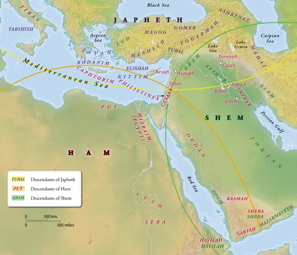
The Table of Nations (Genesis 10)
The biblical text describes the progress of the sinfulness of humankind that was judged climactically in the flood (Gen 6–9). Genesis 10 describes how the nations of the then-known world were derived from Noah’s three surviving sons—Japheth, Ham, and Shem. Their seventy descendants mentioned in Genesis 10 are considered to have been the ancestral heads (= eponyms) of the clans and nations that bore their names (v. 32). The list is divided into three major sections, beginning with those peoples farthest removed from Israel’s horizon and moving toward her nearest neighbors.
First, the fourteen descendants of Japheth are listed (10:2–5); special attention is given to the “sons of Javan,” with whom the Israelites came most often into contact.
Genesis 10:6–20 lists the thirty-one descendants of Ham. In general, these descendants settled in and around the land of Israel but also to the southeast and in Africa. The list gives special attention to the descendants of Canaan (vv. 15–19), with whom the Israelites came into close contact, and to the cities associated with the warrior Nimrod (vv. 8–12).
The final section (Gen. 10:21–31) contains the twenty-six descendants of Shem. As is typical in Genesis, this list, the most important line, occurs last; Abram/Abraham was a descendant of Shem. The list gives special attention to the descendants of Joktan, people who evidently were the eponymous heads of various Arabian tribes.
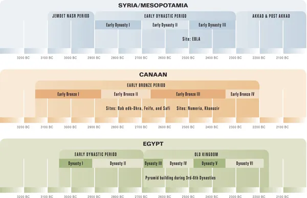
Mesopotamia—Early Bronze Age
In Mesopotamia during the Jemdet Nasr Period (3100–2900 BC) writing began, and large cities containing temples, palaces, and fortifications were first built near the Tigris and Euphrates Rivers. Copper tools came into use, and the population grew significantly. This was the era, according to the Sumerian King List, during which the long-lived members of the pre-flood dynasties ruled.
During the Early Dynastic Period (2900–2300 BC) leadership passed between great cities such as Kish, Uruk, and Ur. These city-states had a unified culture, religion, and language, known as Sumerian. The religious center of this civilization was the city of Nippur. During this period much of the Akkadian epic literature originated.
The Early Dynastic Period ended when Sargon of Akkad conquered the old city-states and established the first empire in the region. His grandson, Naram-Sin, seems to have been especially active in the west, even reaching the Mediterranean coast. During this time the arts flourished and literature developed. The Sargonic Empire (2300–2100 BC) came to an end because of internal and external pressures.
Egypt during the Early Bronze Age
At the beginning of the Early Dynastic Period (3050–2700 BC), Lower and Upper Egypt were united into a single state. Memphis became the capital and remained as such throughout the Old Kingdom Period (2691–2176 BC).
The first king of the First Dynasty was Narmer, and his pallet shows him wearing the crowns of both Upper and Lower Egypt. Egypt had contact with Palestine during his reign because pottery inscribed with his name/symbol has been found at seven different sites. Archaeology also shows that Egypt had contacts with Mesopotamia during this time.
During the Old Kingdom Period the traditional southern boundary at the first cataract was established, the symbols of hieroglyphic writing were stabilized, administrative structures were put into place, and artistic compositions assumed their stylized forms.
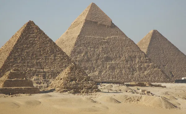
This period is known as the age of the pyramid builders (34 pyramids, out of a total of 47, were built). The pyramids are thought to symbolize the power of the king as well as to emphasize his association with the sun god Re. They were not only burial places but also religious centers of the cult of the deceased god-king. The pyramids of three of the kings of the Fourth Dynasty—Cheops, Chephren, and Mycerinus, located at Giza—are the most famous.
Although the Old Kingdom is well known because of the pyramids, not many documents have been preserved. We know there were extensive contacts with Nubia to the south, from which luxury items such as gold, ivory, and ebony were obtained. To the north, Egyptian gold work has been found in Turkey, and Egyptian artifacts have been found in Lebanon and Syria.
Egypt began to crumble during the Seventh and Eighth Dynasties. Internal factors, such as the cost of maintaining the pyramid cults, weak kings, and possibly a series of below-normal inundations of the Nile that led to famine seem to have led the country into the turbulent days of the First Intermediate Period.
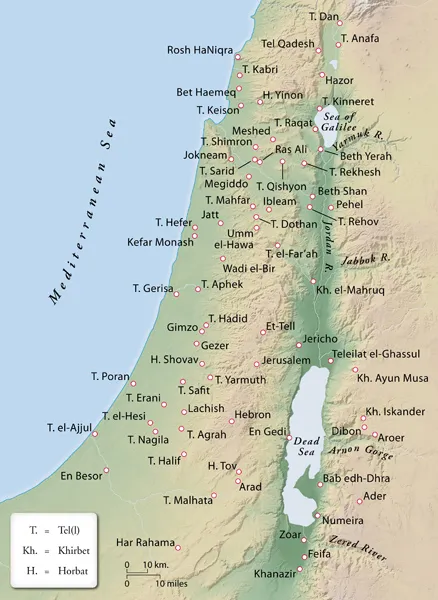
The Southern Levant during the Early Bronze Age
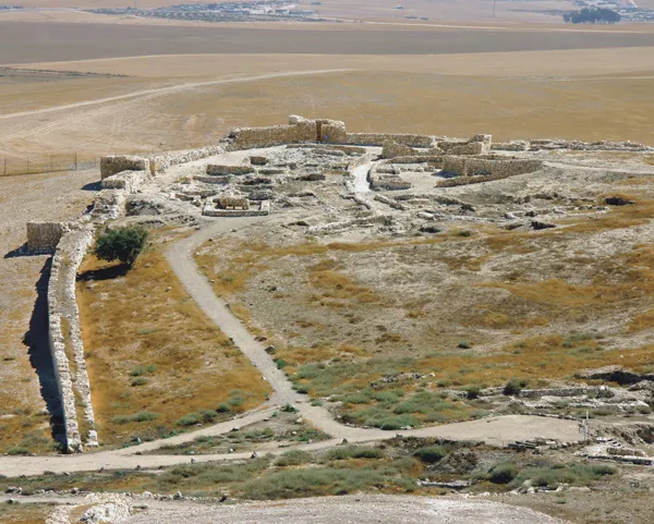
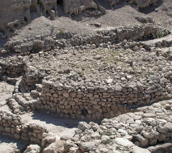
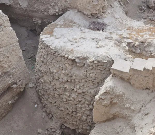
Although human settlement in the southern Levant has had a long history, it was not until the Early Bronze Age (3150–2200 BC) that we begin to see large urban centers. Strong city walls with protruding defensive towers protected most of the large urban centers. At Arad it is estimated that forty such towers were placed at intervals along the 3,840-foot wall.
Typical houses from this period were rectangular in shape, with the entrance placed close to the center of one of the long walls—hence the name “broad house.” The clay model of an Early Bronze house, found at Arad, indicates that the buildings were flat-roofed and windowless. At Megiddo, Arad, and elsewhere, large public buildings, all in the shape of broad houses, appear to have served as temples. At Megiddo four such buildings were discovered in the sacred area along with a large circular altar.
Large burial grounds have been found. At Bab edh-Dhra, for example, it is estimated that some 20,000 tombs contain the remains of 500,000 people. Since there are more burials than the number of people who could have lived in these cities, these cemeteries were probably common burial sites.
In contrast to Egypt and Mesopotamia, no written archives have been found in the southern Levant. One meager reference to the area was found in the tomb inscription of Uni at Abydos in Egypt. H...