![]()
Part 1
THE MOUNTAINS
![]()
CHAPTER 1
Shuffled Texts of Stone
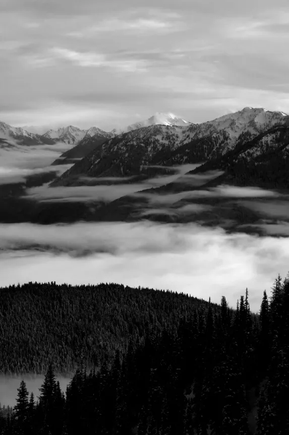
THE Olympic Mountains must have come as a shock to the early European explorers who sailed the west coast of North America. For a thousand miles the coast ranges rose in gently folded hills, sere and treeless to the south, progressively greener and more deeply forested as seafarers sailed north. Suddenly, just past the forty-seventh parallel, the coast hills erupted into a high, rocky jumble of snow-clad summits, ice fields gleaming in the windy light.
Though explorers had plied Pacific Northwest waters since the mid-sixteenth century, the first sighting of the Olympic Mountains wasn’t recorded until 1774. On a clear day in August that year, Spanish seafarer Juan Perez sighted the ice-bound summit of the Olympics’ highest peak and recorded it in his ship’s log as El Cerro de la Santa Rosalia. Fourteen years later, in 1788, British sea captain John Meares spotted the same peak from the Strait of Juan de Fuca to the north. Remote and hidden behind a retinue of ridges and peaks, the mountain struck the captain as a suitable dwelling place for the gods of this new land, and he named it Olympus after the mountain that was home to the gods of Greek mythology. British captain George Vancouver, who explored the inland waters of Puget Sound four years later, extended the name to the range of mountains that surrounded Meares’s Olympus, and the title stuck.
Since “Mount Saint Rosalie” was the first geographic feature to be named by Europeans in what is now Washington State, one might suspect the Olympic Mountains would be among the first in Washington to be explored. Instead, the mystery that shrouded the mythic Greek Mount Olympus prevailed in this far corner of the New World for most of the next century. It wasn’t until the late 1880s, at the close of the American frontier, that systematic explorations of the Olympic Mountains got under way. Although the native people who lived on the peninsula had developed a rich body of myths recounting the creation of this land, the veil of mystery surrounding the geological origins of the Olympic Mountains would remain until quite recently.
In his 1888 report to the secretary of the interior, Washington Territorial Governor Eugene Semple included a section on the Olympic Peninsula:
The mountains seem to rise from the edge of the water, on both sides, in steep ascent to the line of perpetual snow, as though nature had designed to shut up this spot for her safe retreat forever…. In tradition alone has man penetrated its fastness and trod the isles of its continuous woods.
The Seattle Press picked up the call for an expedition that would at last unlock “the mystery which wraps the land encircled by the snow capped Olympic range,” and the following year, a group backed by the Press began a celebrated exploration of the Olympics. It was not the first party to venture into the heart of the interior Olympics, nor the best organized or equipped, but the members of the Press party achieved lasting notoriety for their dogged and persistent traverse through the heart of the range during one of the worst winters on record. Three grueling months after starting up the Elwha River in December 1889, expedition leader James Christie and Captain Charles Barnes slogged through deep snow to a ridge crest north of Mount Wilder and at last laid eyes on the interior mountains. Barnes described the scene in his journal: “Range after range of peaks, snow-clad from base to summit, extended as far as the eye could reach, in splendid confusion.”
The confusion was more Barnes’s than the mountains’; his party had just spent weeks ascending a tributary divide only to realize they had to descend 3,000 feet back to the main valley of the Elwha. But his words would prove prophetic in more ways than the captain could know. A splendid confusion reigned among geologists banging away at Olympic rocks for the better part of the next century.
Field geology, like all natural science, is a process of building on past knowledge, evaluating new data, reexamining assumptions, questioning earlier hypotheses. The knowledge that geologists have gained to date about the origins of the Olympic Mountains, though extensive, is certainly not the last word—as new dating techniques applied to Olympic rocks have recently shown. Nonetheless, the past few decades have proved a watershed in our understanding of the geologic story of the Olympics. The plate tectonics revolution of the 1960s shattered prevailing theories of the Olympics’ origins—as it did all of theoretical geology—and the pieces are still being reassembled. Its impact on geology at the time was equal to that of Darwin’s theories on nineteenth-century biological science. Suddenly, the young, rough-hewn rocks of the Olympic Mountains were seen through a new lens, and the deeper story of this rugged range, so recently added to the North American continent, began to come to light.
Geologists now know that the Olympic Mountains were formed of sedimentary and volcanic rocks, both laid down over millions of years on the abyssal plain of the ocean floor and submerged continental shelf. Seafloor sediments were rafted in, crumpled against the volcanics, and the whole mix plastered onto the edge of the continent like a massive barge running aground on a quiet shoal. But how we’ve come to know this story, and the painstaking work by which geologists pieced together the scrambled puzzle of the Olympics’ orogeny, is as compelling as the sheer heights and shaded canyons of this long-hidden range. That story opens a window into the depth and beauty of these mountains as surely as an evening alone on a ridgetop, listening for the first star.
PIECES OF THE GEOLOGICAL PUZZLE
Early observers in the Olympics assumed that, like many other mountain ranges, bedrock of the mountainous core of the Olympics must be made up of granite and gneiss. These rocks were commonly found as pebbles and boulders in streams flowing north and east out of the mountains. The Press party explorers brought back a first glimpse of the real story; Barnes in particular was able to correctly identify much of the core rock as slate and sandstone. But the specimens they had gathered and packed during months in the mountains were lost when their raft hit a logjam and capsized in the Quinault River. Barnes somehow managed to save his field notes.
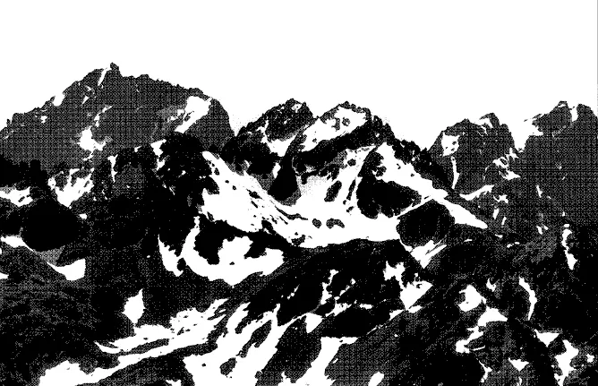
Mount Constance and the rugged east Olympics are carved from marine lavas that flowed onto the continental shelf and seafloor during the Eocene. As the ocean plate collided with the continent, these lavas and associated sedimentary rocks were upended and shoved against the continent’s edge to form the Crescent Formation. PHOTO BY JANIS BURGER.
From such inauspicious beginnings, the story of the origin of the Olympics slowly began to unfold.
In his 1888 report, Governor Semple had described the “continuous array of snow-clad peaks” that bordered Hood Canal to the east and the Strait of Juan de Fuca to the north as composed of basalt, a tough, dark, volcanic rock common to ocean floors. Bulbous “pillow” structures the size of giant watermelons in the eastern Olympics suggest that the lava that formed these rocks erupted underwater and cooled quickly. By the 1930s, Charles Weaver, a geologist from the University of Washington, had identified these basalt rocks as part of the Crescent Formation, a thick horseshoe of basalt that rings the mountains on their north, east, and south sides and extends from Central Vancouver Island in British Columbia south into Oregon. Crescent Formation basalts form the bedrock of some of the Olympics’ most visible and dramatic peaks: Storm King, Mount Angeles, and Tyler Peak to the north; Mount Constance and the double summits of the Brothers on the east; and Mount Tebo and Colonel Bob to the south.
By piecing together the Crescent basalts with the sedimentary rocks of the interior Olympics and the younger sediments that lie outside the basalt horseshoe, Weaver reasoned that the Olympic Mountains formed an anticline, that is, a giant upward fold in the earth’s crust that also tilts down toward Seattle. Subsequent erosion “unroofed” the Olympics, exposing the sedimentary rocks of the interior. This theory neatly explained how the basalt horseshoe of the Crescent Formation formed around what were believed to be the older rocks of the interior. Fossils found in the Crescent rocks dated to the Eocene epoch, about 45 million to 60 million years ago, but no fossils had been located in the sedimentary core rocks. Weaver’s anticline theory of the Olympics’ formation, the mountains’ folding and uplift caused by “tectonic forces deep in the earth’s crust,” would remain intact for the next forty years. But throughout that time, the story became increasingly complex, and continuing field research brought almost as many questions as answers.
Natural oil seeps, first noted in Olympic sea cliffs in 1881, touched off an oil rush at the turn of the twentieth century. All of the more than a hundred wells drilled were unsuccessful, but company geologists located fossil foraminifera in the sedimentary rocks. These microscopic, chambered protozoa were ubiquitous in the earth’s oceans over a long period of time, and they evolved rapidly. This enabled paleontologists to date layers of marine rock with a high degree of accuracy. The age of these fossils showed that some of the core rocks were actually younger than the Crescent basalts. This finding cast doubt on the anticline theory. If the theory was to hold, it would need serious modification. The plot was beginning to thicken.
Studies of the Olympics’ rocks intensified in the years leading to World War II when manganese was in great demand. With work done by Charles Park Jr. of the U.S. Geological Survey, additional pieces of the puzzle began to fall into place, and an improved geologic map of the Olympics was developed. Park found even younger fossils in the core rocks. They dated from the Oligocene epoch, around 22 million to 38 million years ago. The core rocks were incredibly faulted, broken up, and restacked, so geologists assumed the basalts were that way too. Park’s work and research done later by Wilbert Danner and other geologists from the University of Washington established the age and distribution of many of the Olympics’ rocks. Scientists now knew what the mountains were made of, how the rocks came to be, and when some of them were deposited. Some of Barnes’s splendor was beginning to wear off the confusion. But the larger story of how the mountains were born remained hidden.
THE FLOOR OF AN ANCIENT SEA
Throughout Tertiary time, which began about 60 million years ago, the coast of North America was located farther to the east than it is now. The area that was to become the Olympic Peninsula lay quietly beneath the waves of a coastal sea. Rivers pouring off the western edge of the continent carried silt, sand, pebbles, and rocks. Rivers, or perhaps a great single river—an ancestral Fraser or Columbia—eroded the low mountains of old northwestern North America. Where rivers met salt water they slowed, dropped their load of materials and formed deltas on the continental shelf, just as they do today.
As river deltas stacked higher and steeper, earthquakes regularly triggered massive collapses. Undersea landslides of sediments peeled off deltas and flowed out over the shelf onto deep ocean floors in dense riverine slurries called turbidity currents. These undersea rivers formed channels and fans across the deep ocean floor. Propelled by the density of sediment-heavy water, they flowed in some cases for hundreds of miles. The current Cascadia channel, fed by the Fraser, western Olympic and Columbia rivers, extends 1,300 miles across the Pacific Ocean basin. Depending on the frequency and nature of the submarine landslide events, most sands were deposited in thick beds in deep channels. Some sands, silt, and mud overflowed the channels and fanned out over miles; these became interbedded with layers of finer sediments as they settled through calm water. As the process repeated over millions of years, and layers thickened in the cold depths of the sea, sedimentary rocks formed. Sands compacted into sandstone, finer sediments into siltstone and shale. Occasionally slurries would contain pebbles, forming conglomerate, or broken chips of mud and rock, which became breccia. These black chips are ubiquitous in sandstone pebbles scattered over western Olympic rivers and beaches.
Thick, erosion-resistant beds of sandstone in “fossil” sea-bottom channels have been tilted on end and now compose the bedrock of the highest peaks of the Olympics’ inner core, including Mount Olympus, Mount Anderson, and most of the Bailey Range.
Between the turbidity channels, thinner, weaker beds of sandstone, siltstone, and shale stacked up in layers. These formations are more subject to erosion, but evidence of these rhythmic beds is found today throughout the mountains. Particularly noticeable outcrops appear on Blue Mountain along the Deer Park Road. Sandstones, made up of grains of quartz, feldspar, and mica can be easily distinguished. Shales, made up of clay minerals, are composed of grains much too fine to see. Very few of the sedimentary rocks of the Olympics were buried deep enough or long enough for intense metamorphism to occur. It is estimated that sedimentary rocks accumulated on the seafloor off the continental coast in the area to become the Olympic Mountains were five miles deep.
Geologists working in the Olympics marveled at the intensity of deformation in the sedimentary core rocks. Instead of neat beds stacked up chronologically like the rocks of the Grand Canyon, strata laid out horizontally along the ocean floor were bent, broken, smashed, smeared, and restacked as though kneaded by a very large baker. Rarely do rocks become this deformed without having undergone extensive metamorphism. The degree of deformation of the Olympic rocks bears witness to the tremendous forces that built these mountains. But before plunging into that part of the story, we’ll need to step back a few decades and revisit the state of geological knowledge as it stood in the 1950s.
THE PLATE TECTONICS REVOLUTION
World War II has been described as a technological piñata. Among other breakthroughs, sensitive technologies developed for locating German submarines proved a windfall for oceanographers mapping the ocean floor. In the years that followed the war, detailed topographic maps of the sea bottom revealed some fascinating features. Long mountain ranges marked by central rift valleys traversed the centers of most ocean floors. Seafloors rippled off along either side of these ridges, then dropped into deep trenches that bordered the edges of continents. Geologists were able to measure the orientation of the earth’s magnetism as recorded in ocean floors. They discovered some surprising patterns.
Ocean floors are composed of basalt, and basalts are rich in iron. As molten lava cools to form basalt, its iron-oxide magnetite crystals align with the earth’s magnetic field. Scientists have long known that the earth reverses its magnetic field every several hundred thousand years; the last magnetic reversal was about 780,000 years ago. Cooling basalt retains the magnetic polarity of the earth at the time it solidifies. Scientists working in the north Pacific discovered a striped pattern of magnetic reversals spreading out symmetrically along both sides of the ocean ridges. The north-south-running patterns were identical to each other. Geologists identified similar magnetic reversals within older lavas on land. Later core dating showed that ocean floors became progressively older the farther one progressed from midocean ridges, with the oldest dates near the edges of continents. But the ocean floor dates in general were curiously young. At 150 million years, the oldest dated seafloors proved much younger than the oldest rocks on the continent, which are 3.8 billion years old. This raised an obvious question: What happened to the older seafloors?
By the mid-1960s, an explanation emerged. It became clear that seafloors are formed along central spreading ridges by lava upwelling from the earth’s mantle. As r...