![]()
Chapter 1
Physical Landscape and Natural Surroundings
Denver is an improbable city. Its origin is a bit unlikely as it lacked several of the favorable conditions from which cities typically emerge. There was no natural abundant water source to support a large, successful agricultural settlement, nor a navigable waterway. It was not located along any major trade route. In fact, the impenetrable Rocky Mountains forced the early east-west routes to traverse through Santa Fe, New Mexico, to the south, and Cheyenne, Wyoming, to the north. Nor did the region have an ideal balance of proximity to resources, markets, labor, and transportation networks central to the emergence of so many eastern U.S. industrial towns. But as it became an “instant city,” Denver’s founding and continuance to thrive rests on its hinterland and the inextricable economic ties to its natural surroundings. This chapter details several physical geographic characteristics central to answering the question: what is Denver today, and how did it evolve historically?
Denver’s Hinterland
Understanding Denver’s hinterland begins with placing the city in the larger context of the state of Colorado. A map of Colorado can generally be divided into three sections that approximate the state’s primary natural regions. Each region contains distinctive topography, natural resources, vegetation, and climate, helping to create a diverse landscape (Figure 5).1 These regions not only shaped Denver’s early economic and social fortunes but also remain integral today.
Figure 5. Colorado regional map. (Map created by E. Eric Boschmann and Court Ballinger; map data sources: Esri, NOAA, USGS.)
The Eastern Plains
The eastern section of Colorado is characterized as a large, relatively flat terrain of plains and prairie landscape, with dominant vegetation of low grasses and few trees except deciduous cottonwoods and willows that follow the paths of streams and rivers. Its elevation between four thousand and six thousand feet above sea level gradually inclines westerly toward the base of the Rocky Mountain range.2 For contemporary travelers driving into Colorado from the east, this vast expanse is often seen as an unpleasant car ride that must be endured to reach the mountains. But while much emphasis is placed on the natural amenities of the Rocky Mountain region in Colorado, the eastern plains had significant impacts in shaping the Front Range urban corridor, of which Denver forms a part.3
Denver was founded much later than many West Coast and southwestern cities including Santa Fe (1610), Albuquerque (1706), San Diego (1769), Tucson (1775), San Francisco (1776), Los Angeles (1781), Seattle (1851), and Portland (1851). While the Rocky Mountains did create an impenetrable barrier during early westward expansion of the United States, it was the conditions and early perceptions of the eastern plains that made the area more likely to be avoided than explored.
The eastern plains, on which Denver is situated, was once described as “parched country,” a land “almost wholly unfit for cultivation, and uninhabitable by people depending upon agriculture for their subsistence.”4 So strong was this assessment of the area as an inhospitable, arid, and barren landscape that early maps of the region labeled it the “Great American Desert.”5 No explorer in the early 1800s would have predicted that a thriving metropolitan area with over 2.6 million people would blossom in this seemingly unproductive land.
Also at that time, great fear of Native American peoples living in the eastern plains gave pause to European American pursuits in the area. The longest continuous inhabitants of Colorado are the Utes, with ancestral roots reaching back ten thousand years and extending to today’s Southern Ute Indian Reservation in southwestern Colorado.6 They are considered the only Native Americans indigenous to Colorado. Other First Coloradans were the Anasazi (Ancestral Puebloans), who resided in western Colorado from approximately 600 to 1300 C.E. Together, these First Coloradans demonstrated adaptability and resourcefulness in the sometimes harsh and changing Colorado landscape. Through creativity and pragmatism, they understood what was possible from the local environment. It is estimated that in 1100 C.E. nearly thirty thousand Ancestral Puebloans lived in a land of abundance. They learned the seasonal variations of water and used capture and conservation strategies to maintain maize, beans, and squash crops with only sixteen inches of annual rainfall. A great drought descended on the region in the mid-1200s. In this period of scarcity and fragility, the Ancestral Puebloans established cliff dwellings (preserved today at the Mesa Verde National Park) and ultimately abandoned the region by 1280.
Along the Denver Front Range the region was most likely used by a series of different tribes over time, including the Ute, Apache, Cheyenne, and Arapaho. Given the semiarid climate and the extremes in seasonal weather, it was an area best suited for nomadic existence of hunters and gatherers, often transitioning between the plains, the foothills, and the mountains. Evidence today shows that the protected alcoves created by the hogback ridges and red rock uplifts along the Front Range served as temporary shelters during times of transition. Hunting in the foothills and mountains consisted largely of elk, deer, and bighorn sheep, with more bison and black-tailed prairie dogs on the plains.7 At the time of European contact and expansion in North America during the 1500–1600s, the Utes occupied the mountain region of Colorado, while the Apaches occupied the plains. When Denver was settled by European Americans in the 1850s, the Cheyenne and Arapaho dominated in the plains. As was true for much of the westward expansion era, fear of Native Americans often escalated into great catastrophes, losses, and forced displacement. In Colorado’s history, both the 1864 Sand Creek Massacre and the 1879 Meeker Massacre represent horrific actions taken in pursuit of settling this region (see Chapter 2).
Across Colorado, place names (toponyms) reflect the local history of First Coloradans, including counties (e.g., Arapahoe), cities (e.g., Pueblo, Ouray), and street names (e.g., Zuni and Navajo in Denver). In addition to the snow-capped mountain peaks, many teepees would have dotted the plains landscape when European American settlers first arrived.8 The historic legacy of First Coloradans remains important today for understanding regional history and reconciling with the events of domination and displacement. But also, as Coloradans today consider how to live in Colorado with changing environmental conditions, there are lessons to be learned from First Coloradans, who made hard decisions and adapted in times of scarcity.
By the 1870s, perceptions of the eastern plains as the Great American Desert changed. Southern and western Colorado regions had already utilized Spanish acequia irrigation techniques, a community-based system of shared building, maintenance, and management of irrigation ditches. These practices were adapted and transferred to the eastern plains where a network of ditches and canals were built along the Rocky Mountain–fed South Platte and Arkansas River valleys. Along the South Platte River in northeastern Colorado, early cattle ranchers supplemented grassland grazing with irrigated cattle crops (hay or alfalfa). This region also became important to sugar beet farming, where the Great Western Sugar Company dominated. Similarly, in the southeastern Arkansas River valley cattle feed crops were irrigated, as were melon crops and small fruit orchards. The eastern plains also developed dry-land agricultural industries, particularly in wheat and barley grains. Since the 1950s, center pivot irrigation has pumped water up from the Ogallala Aquifer, creating a new economy of water-intensive crops (soybeans, corn) that fetch higher market values. And in addition to crop cultivation and cattle ranching, these resources grown on the eastern plains were also processed for export through numerous canneries, sugar refineries, breweries, meatpacking plants, and flourmills. As discussed later (Chapter 2), this agricultural industry in Denver’s hinterland of the eastern plains has long been central to the city’s economy and identity.
The Mountains
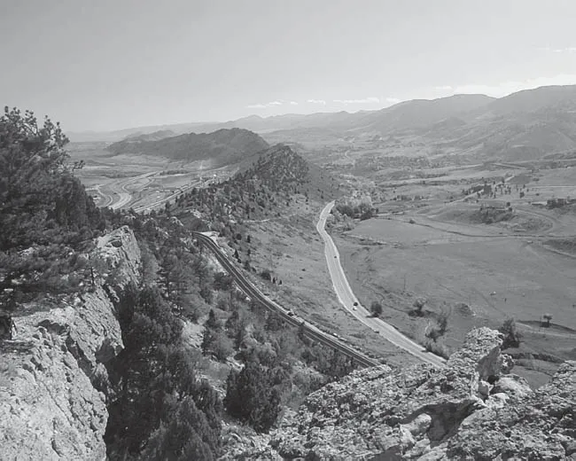
Denver sits in the geologic transition zone where the eastern plains give way to the Rocky Mountains. The Rockies were formed eighty million years ago by tectonic plates sliding under the North American plate at a shallow angle of subduction, causing uplift. The mountains were further shaped by ongoing tectonic activity and erosion, resulting in a series of extraordinarily broad and high mountain ranges. The foothills are considered the higher terrain between six thousand and nine thousand feet immediately to the west of Denver and the rest of the Front Range urban corridor. This area contains many interesting geologic structures such as the Dakota Hogbacks, a ridge outcropping of steeply dipping sedimentary rock where sandstone tilts at a sixty-degree angle after millions of years of uplift and erosion. What was once a prehistoric ocean floor is today a geologic wonderland and includes dinosaur tracks and fossil segments from the Jurassic period 160 million years ago (Figure 6). Within these sandstone outcroppings humans have created many iconic parks, including the Red Rocks Amphitheater and Roxborough Park in the Denver area, or the Garden of the Gods in Colorado Springs.
Figure 6. Dakota Hogback geologic formation, west of Denver. (Photo courtesy of Jeremy McCreary.)
This mountain region of Colorado is where the long Rocky Mountain range running the length of North America reaches its highest. It creates a diverse montane, subalpine, and alpine landscape of mountain peaks separated by river canyons and valley plains. Rather than a single range of mountains, there are several north-south-running ranges, such as the Front Range, Sangre de Cristo, Sawatch, or the San Juan Mountains. The Continental Divide runs through here separating mountain water runoff between westward flow to the Pacific Ocean and eastward flow to the Gulf of Mexico. The natural forest landscape is dominated by coniferous trees such as spruce-fir, ponderosa pine, lodgepole pine, piñon-juniper, and the deciduous aspen. With moisture fronts flowing in from the Pacific Ocean, the high country receives between twenty-five and fifty inches or more of precipitation annually, usually in the form of snowfall. This creates Colorado’s snowcapped landscape, fuels the snow-based industries of skiing and snowboarding, and provides municipal water supply to millions of western U.S. residents. These mountains are the headwaters for many major rivers that flow through surrounding western, southwestern, and central plains states.
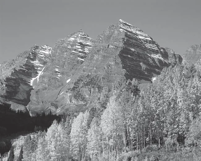
This region contains more mountain peaks (fifty-four in all) above fourteen thousand feet (referred to as “fourteeners”) than anywhere else in North America, and with a relatively high average elevation throughout Colorado, it is often considered the rooftop of the continent. For tourists, residents, and adventurists alike, the picturesque mountain peaks have come to symbolize an idealized natural world (see Chapter 4). Specific physical landscape scenes, such as the oft-photographed Maroon Bells near Aspen, create iconic identities of place (Figure 7). And through time many of Colorado’s peaks evolved into cultural icons for local communities (such as Mount Evans and Longs Peak as the peaks of identity for Denver), while others, such as Pikes Peak, foster a larger national identity. The majestic nature and vastness of the mountains have long inspired a sense of awe and wonder; it was atop Pikes Peak in 1893 that Katharine Lee Bates wrote a poem that would become the lyrics for America the Beautiful. Today, outdoor recreation including hiking, camping, biking, skiing, and water rafting establish a centrality of activity in this mountain landscape. The allure of the mountains and an ethos of recreationalism foster many urban-based adventurist subcultures. For instance, “peak baggers,” who may live and work in Denver, are individuals that spend their weekends and free time aspiring to hike up every fourteener mountain for the thrill of mountaineering, skill, and endurance.9
Prior to the mountain landscapes’ role in tourism and recreational industries of Denver and Colorado, their importance rested in the abundance of natural resources. From 1820 to 1840 the fur trade peaked in the Rocky Mountains and helped provide supply to the popular fashion of beaver fur hats in the eastern United States and across Europe. Eventually silk hats became more fashionable and decimated the fur trade. But it was the abundance of mining opportunities in the mountain region that brought about the greatest economic change, as Colorado contains over seven hundred minerals. Some of the most historically important and heavily mined have been gold, silver, lead, zinc, molybdenum, copper, and tungsten. Today’s mountain landscape is dotted with both abandoned and active mines, and many old mining mountain towns live on as destinations for tourists seeking the old ghost town mystique. Across all regions of Colorado exist energy sources of oil, natural gas, oil shale, coal, and uranium.10 All these extractive industries in the mountains were instrumental to the economic success of the Denver region and the state as a whole. But they are also at the core of modern environmental tensions, between traditional economies of resource extraction, and the economies dependent on protecting a clean environment and ensuring the preservation of picturesque scenery.
Figure 7. The Maroon Bells, near Aspen, Colorado. (Image source: Jesse Varner, Creative Commons CC-BY-SA-2.0.)
The Western Slope
The westernmost section of the state is known as the Western Slope—where the Rocky Mountain range meets the high Colorado Plateau. Here the physical landscape transitions from the rugged mountain peak and valley system to one of more mesas, canyons, escarpments, and floodplains. Geologic time is highly evident in many colorful rock formations and visible stratigraphy. The city of Grand Junction serves as the historical regional center where uranium, molybdenum, and oil dominate the extractive resource economy. With less alpine terrain, there is limited downhill skiing in the Western Slope, but tourism exists for biking and water rafting sports, as well as visiting natural hot springs, such as at Glenwood Springs. The Grand Valley River project of 1925 diverted the Colorado River to supply water to agricultural lands in the counties surrounding Grand Junction for the sugar beet industry; today it creates a bountiful landscape of fruit tree orchards, including apples, cherries, peaches, and numerous vineyards. While geographically remote from the Denver urban area—much of it over a half day’s drive away—the important agricultural, mining, and tourism economies of the Western Slope keep Denver inextricably tied to this region.
Climate
Denver’s climate is influenced by three major features: the city is situated at a high elevation on the high plains, it sits along the east side of the Rocky Mountains where jet streams flow west to east, and it has a deep interior continental and midlatitude location. The regional climate is classified as a semiarid st...