![]()
1
A Life Aquatic?
Looking at the relationships between settlements, rock art and sea levels in the Himmelstalund region of eastern Sweden
Per Nilsson
The existence of rock-art panels surrounding the Motala River to the west of the city of Norrköping has been well known among Scandinavian Bronze Age researchers since the late 19th century. Abundant and varied motifs can be found at locations such as Himmelstalund, Fiskeby and Ekenberg. One of Sweden’s largest prehistoric settlements was discovered in the same area, at Pryssgården, during the early 1990s – the settlement having been densely inhabited in the Late Bronze- and Early Iron Age. Recent excavations south of the settlement show that areas previously regarded as marshland, or even submerged land, were also settled. In this article I present some of the results of these excavations, including one made in close connection to the most famous rock-art site, Himmelstalund. The major rock-art sites are often interpreted as possible meeting-places where both religious ceremonies and trading activities took place. It is suggested here that one of the main reasons why such gatherings occurred at this special place was that the river offered exceptionally good seasonal fishing opportunities.
Introduction
This article aims at a discussion of Bronze- and Early Iron Age settlements, shore displacement and livelihood in one of the best known rock-art regions of southern Scandinavia; the area surrounding the former outflow of the Motala River, situated to the west of Norrköping in the south-eastern part of Sweden. The region is well known for its number of rock-art sites, examples of which include Himmelstalund, Ekenberg and Fiskeby (Figure 1.1).
In this article I present and discuss results of excavations closely connected with some of the rock-art sites. New C14-datings indicate that there was more dry land during the Bronze- and Early Iron Age than has previously been estimated. Excavations made in recent years also show that settlements from this period can be found at lower levels than were earlier thought possible. This is interesting, because it provides useful data for addressing the question of what kind of landscape surrounded the rock-art sites and their eventual connection to water or marshlands. It now seems possible to find settlements, and perhaps even rock-art sites, at levels as low as 10–15 metres above the present sea level. Although it seems that there was more inhabitable land during this period than previously estimated, this ground must have been quite damp for parts of the year. In this article I aim to discuss some of the possible reasons why people chose to settle in these periodically hostile environments.
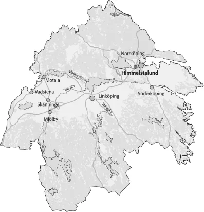
Figure 1.1: Map showing the geographical location of Himmelstalund.
Rapids and research
During the Bronze Age, an isthmus to the north of the river separated a deep gulf of the Baltic Sea in the east from Lake Glan in the west (Figure 1.2). It was a place where inland routes met the Baltic Sea, and the region has been depicted as the main entrance to this part of Sweden (Larsson 1993, 137, Stålbom 1995, 57). About a kilometre east of the rapid-flowing currents at Fiskeby, the waters became calmer. The most famous rock-art site, Himmelstalund, is to be found here close by the river. This area has been pointed out as a possible anchorage for ships that were providing Scandinavia not only with bronze, but with symbols and a symbolism inspired by the material culture of Central Europe and even the Mediterranean (Larsson 1993, 109 ff, Kristiansen and Larsson 2005).
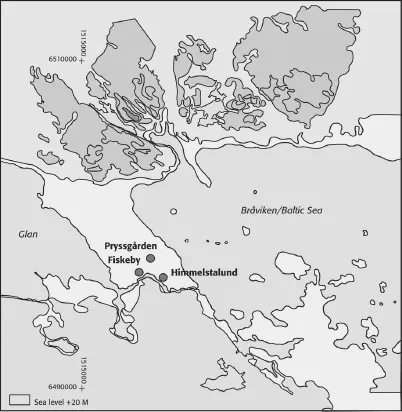
Figure 1.2: Reconstruction of the landscape with a sea-level of 20 metres above the present one. Based on a map from Borna-Ahlkvist 2002. Scale 1:100 000.
Lately, however, questions have arisen as to whether the Motala River really was a suitable route, particularly as the falls and rapids at Fiskeby are seen rather as gateways out of the country – the falls being the passage you had to physically or symbolically go through on your way towards the unknown (Hauptman-Wahlgren 2002, 29). The idea that rock-art sites were some kind of trading places has also been challenged, from the point of view that excavations have failed to show any clear connection between rock-art sites and trade (Hauptman-Wahlgren 2002, 29). Issues concerning Bronze Age societies in this region have been of special interest in recent years, with dissertations focussing both on the rock-art site and the large settlements found in the area (Borna-Ahlkvist 2002, Hauptman-Wahlgren 2002 and Fredell 2003). At Pryssgården, less than a kilometre north of the river, one of the largest prehistoric settlements in Sweden was excavated in the 1990s (Figure 1.2). The settlement contained over 90 houses, most of which are datable to the Bronze Age and the Early Iron Age (Borna-Ahlkvist et al. 1998).
The Fiskeby settlement
A few years ago, The Swedish National Heritage Board completed major initial excavations in the area between the river to the south and the Pryssgården-settlement to the north (figures 1.2–3). While these excavations revealed a site that was structurally very similar to the large settlement previously found at Pryssgården, there was a difference in the kind of ground chosen for habitation. At Pryssgården the ground consisted of sandy, thoroughly drained soil, while the newly discovered settlement at Fiskeby was established on a clay soil that retains its moisture for long periods of time (Nilsson 2005a, Nilsson 2007a). Radiocarbon datings from the excavation site range from Late Bronze Age to Early Roman Iron Age, i.e. from about 600 BC to 300 AD. The settlement seems to have been established during the latter part of the Late Bronze Age and at its most intense during the Pre-Roman and Early Roman Iron Age.
At Fiskeby, just a few hundred metres southwest of the newly discovered settlement, a large grave-field with more than 500 burials was excavated in the 1950s (Figure 1.3) (Lundström 1965, 1970). This grave-field appears to have been in use from the Late Bronze Age to the Late Iron Age. Because of the close connection in both time and space between the settlement and the grave-field, we have chosen to call it the Fiskeby Settlement (in Swedish: Fiskebyboplatsen).
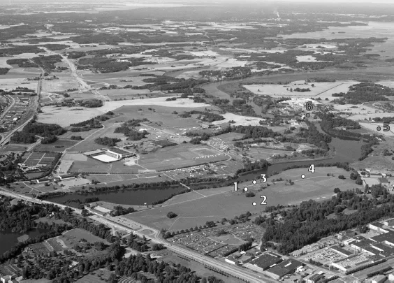
Figure 1.3: The landscape surrounding immelstalund with the Lake Glan to the right. 1. The Himmelstalund-rock 2. Late Neolithic/Early Bronze Age settlement. 3. House and hearths. 4. Larger settlement. 5. The Fiskeby Settlement. 6. Rapids and grave-field at Fiskeby. Photo by Jan Norrman.
Initial excavations have shown that the complex of prehistoric settlements was even larger than had been estimated by, for example, Borna-Ahlkvist (2002, 14). The excavations also showed that extensive settlements were situated between the river to the south and the Pryssgården-settlement to the north – an area previously regarded as marshland, or at best waterlogged pasture during prehistoric times (Borna-Ahlkvist 2002, 15). In order to understand why settlements were located here, it is important to discuss how shore displacement changed the environment during the Bronze Age and Early Iron Age. With regard to the region as a whole, the sea level is supposed to have been about 20 metres above the present sea level during the Early Bronze Age and about 15 metres during the Late Bronze Age (Borna-Ahlkvist et al. 1998, Hauptman-Wahlgren 2002, 27). These levels have been used in landscape reconstructions by researchers working in this area for some years. The results of C-14-datings from several excavations now show that these estimated levels have to be questioned. Before turning to the subject of sea levels and the question of why people chose to settle here, however, I would like to discuss some of the region’s settlements that are similarly situated.
Settlements by the river
At Himmelstalund, about 100 metres north of the rock-art site, remains of a prehistoric settlement were found at an altitude of about 22–26 m.a.s.l. (Figure 1.3) (Persson 1998). A minor excavation revealed post-holes, hearths, cultural layers, etc. Two features were dated to the Late Neolithic/Early Bronze Age at a level of + 22.80 m.a.s.l. (3370±60 BP, 1970–1510 cal BC) and + 23.42 m.a.s.l. (3520±60 BP, 1770–1510 cal BC). The foot of the rock is at a level of about 26 metres.
It has previously been estimated that during the Bronze Age the Himmelstalundrock was situated on a small island (Kaliff 1997, 40), or at least located in a kind of marshland that was almost inaccessible for parts of the year (Hauptman-Wahlgren 2002, 47). Weapon-motifs like swords, daggers and some of the axes have been interpreted as being the oldest rock-carving motifs of this region. Some of them probably date back as far as the Early Bronze Age Period II, around 1600 BC (Hildebrand 1869, Nordén 1925, Larsson 1986a, 143, Hauptman-Wahlgren 2002, 178). If this dating is correct, then the site to the north of the rock may be contemporary with, or even older than the oldest motifs on the Himmelstalund-rock. The early dating of the settlement north of the rock thus raises doubts about the previous conception of the environment surrounding the rock-art site. The fact that people were using the site at about the same time or even before the first motifs were cut into stone is also of considerable interest.
A few years ago, another excavation was made close to the rock-art site at Himmelstalund, this time between the rock and the nearby Motala River (Ericsson and Nilsson 2007, Nilsson 2008b). The excavation was made because a new road for cyclists and pedestrians was to be built. At two places along the planned road we found traces of prehistoric settlements (Figure 1.3). About ten metres beneath the rock, a small house and some hearths were found. The house was three-aisled, about 7.5×3 metres in diameter and C14-dated to 2000±30 BP (45 cal BC–55 cal AD). Some 100 metres to the west of the rock with the carvings, excavations revealed a minor part of what appears to have been a larger settlement. In an area of not more than 15×10 metres there were three large wells, hearths, an earth oven and some cooking pits. The features contained plenty of pot-sherds, animal bones, pieces of slag (not from metalworking) and several rubbing stones, and on top of one of the filled-in wells was a grinding stone. Both the features and the finds speak in favour of a stable settlement. The C14-datings from the larger settlement range from 2140–1820 BP (350 cal BC–235 cal AD). Five of the seven samples were dated to 2010–1950 BP. It seems clear that a more stable settlement was established in close proximity to the rock-art site in the late Pre-Roman Iron Age. An obvious question is naturally whether the people living in this settlement were still creating (or perhaps re-using) rock-art? Were the rock-art site long-forgotten ones, or were they still in use in some context during this period? Later research has shown that the Bronze Age tradition of making rock-art in Scandinavia was probably still in existence in some areas also during the Pre-Roman Iron Age (500–0 BC) (Kaul 1998, 104f, Hauptman-Wahlgren 2002, 179). Two hearths dated to the Early Iron Age found in close connection to one of the panels at Himmelstalund speak in favour of such an interpretation (Nilsson 2008a–b). I aim to explore these topics further in a forthcoming article (Nilsson in press).
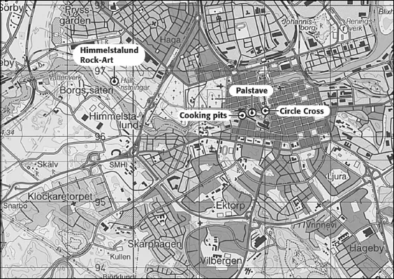
Following the river further to the east, we move to what is today the central part of the city of Norrköping (Figure 1.4). As has previously been mentioned, the sea level in this region is supposed to have been about 20 metres above the present level during the Early Bronze Age and about 15 metres during the Late Bronze Age. A sea level of 20 metres above that of today would have meant that the Lake Glan was separated from the Baltic Sea and the rapidly flowing currents would have formed at Fiskeby. As the sea level fell to 15 m.a.s.l., falls and torrents would have formed where central Norrköping is now situated. Not far from the torrents, along the Kungsgatan road on the south bank of the river, prehistoric settlements have been located, preserved beneath the cultural layers of the town (Figure 1.4). Here, three cooking pits were excavated and C-14 dated to the Bronze Age; two being dated to the Early Bronze Age, 3130±70 BP (1500–1310 BC) and 3070±65 BP (1430–1210 BC) while one was dated to the Late Bronze Age, 2765±70 BP (1000–830 BC) (Lindgren-Hertz 1999). The cooking pits were found close to the river at an altitude of only 17 metres above the present sea level. Not far from the pits, a palstave with spiral ornaments was found at the bottom of the river. It has been dated to the Early Bronze Age, Period II (1500–1300 BC) and may thus be contemporary with two of the cooking pits (Oldeberg 1974, 292f).
Figure 1.4: Map showing the central part of Norrköping. Scale 1:50 000.
Another interesting site is Wilhelmsberg, located less than two kilometers north of the Pryssgården settlement. Here a cooking-pit has been C14-dated to 800–400 cal BC at an altitude of only 7.86 m.a.s.l. (Petterson and Ulfhielm 2000).
More detailed studies of the shore displacement in this region are necessary. But considering these early datings and the location of the above mentioned features low altitude above the sea level, I think it is reasonable to suggest that during the Early Bronze Age, sea level was about 15 metres above the present one and about 10 metres during the Late Bronze Age. In the transitional period between the Late Bronze/Early Iron Age, it is possible that the sea level may even have been below 10 metres. The difference in sea-level of just a few metres may seem insignificant, but since the Norrköping district is largely composed of flat land, changes in sea level would have had a considerable effect on the landscape.
The circle-cross at Knäppingsborg
The cooking pits in central Norrköping were found close to the site of the region’s earliest documented rock-art figure. A treatise from the 1740s describes a now lost circle-cross figure located on the so-called Knäppingsborg rock, which was situated beside the river in the centre of the town (Figure 1.4) (Lithzenius 1742, 46). In 1925, the well-known Swedish Bronze Age researcher, Arthur Nordén, used this circle-cross as a landmark to reconstruct the sea-level in this area during the Bronze Age (Nordén 1925). The circle-cross would have been situated a mere seven metres above sea level, which is why most later researchers have assumed that it could not have been made during the Bronze Age. In view of the new estimations of sea levels in this region, this assumption must also be challenged. Another possibility is that the circle-cross was only visible during periods of extremely low water, e.g. during certain parts of the year. If this is true, it would parallel the carvings at Nämforsen and Norrfors in northern Sweden. At both these sites, a number of rock-carvings are below the surface at high water, and some of them are even eroded by the prevailing streams and currents (Goldhahn 2002, 63). This can be compared with a passage from the 1740s document which states that the circle-cross at Knäppingsborg: ...