![]()
1
Introduction
The site
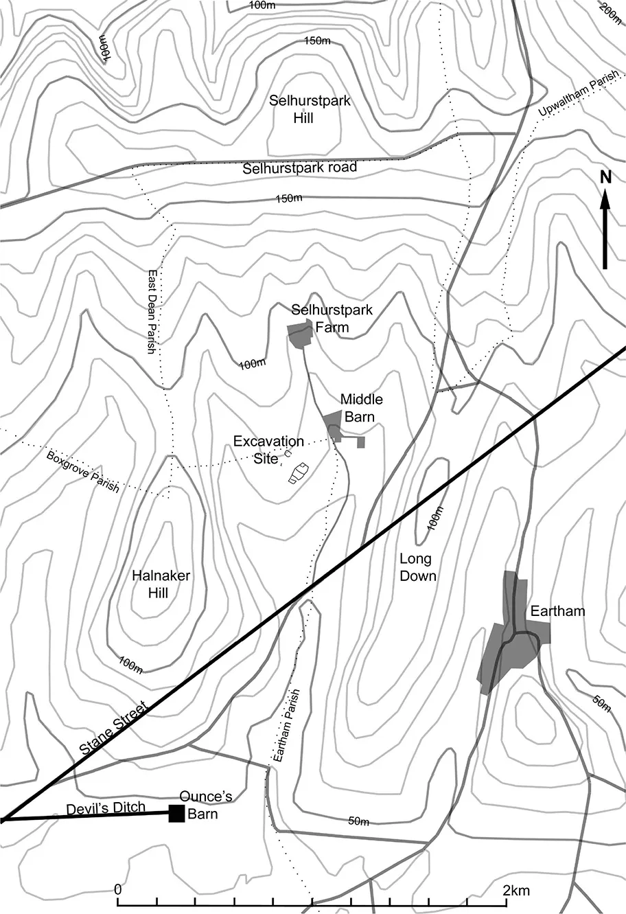
The site of the Iron Age and Roman settlement at Middle Barn, on the South Downs in West Sussex, is centred at SU927 51030. It lies at 75 m aOD and is set upon a spur of land, facing south-south-east and projecting into the head of a small valley running almost due south from Selhurstpark Hill (see Figs 1.1 and 1.2). The underlying geology consists of Cretaceous Upper (Newhaven) Chalk, overlain by flinty shallow well drained calcareous silty soils of the Andover 2 association (British Geological Survey 1996; Soil Survey of England and Wales 1983).
Figure 1.1 The location of the site
Figure 1.2 The Selhurst Park valley
The valley as a whole is approximately 3 km long from its head, just south of Selhurstpark road at 150 m aOD, to its entrance, as it emerges onto the Sussex coastal plain, at 50 m aOD. Its width, as measured between the summits of Halnaker Hill, which forms its west side, and Long Down, along its east side, narrows from c. 1.75 km wide at its head, to c. 1 km wide at its entrance (see Fig. 1.2). It is crossed obliquely by the line of Roman Stane Street which, ignoring the natural contours, passes over the ridge of Long Down about half way down its length, and exits across the lower slopes of Halnaker Hill, to run on to the city of Chichester, 7.5 km to the south-west.
The south-west part of this valley, including the site of the settlement, lies within the modern parish of Boxgrove, whilst the remainder is within the parish of Eartham. However, until the late 20th century the whole of the northern half of the valley was included within the neighbouring parish of East Dean.
Historic maps
The earliest depiction of the area of the site upon historic mapping is that from a map dating to the late 16th or early 17th century which is held in the archives of Arundel Castle (Arundel Castle Archives PM193). This shows it lying within the medieval deer park of Selhurst, with the park pale following the southern edge of the field within which it is now situated. A subsequent map, dated 1629, indicates that 74 acres (c. 30 ha) of the park, including the settlement site, formed part of the manor of Oldburie and Sebeach, within the Tithing of Halnaker and parish of Boxgrove, which was held under lease from King Charles I by Sir William Morley (West Sussex Record Office Goodwood Archive E4982). The area containing the site is shown on this map as fenced off from the remainder of the park, and appears to be wood pasture. A subsequent map of 18th century date shows this fenced-off area as an arable field (West Sussex Record Office Par 27/6/7), a land-use which was to continue, with periodic reversions to pasture, until the present day.
Aerial photographs
The identification of an historic settlement at Middle Barn was made by Jerome O’Hea in the very dry summer of 1976, who captured a series of oblique aerial photographs. In 1978 an interpretative transcription of one of the photographs was made by Fred Aldsworth, then County Archaeologist with West Sussex County Council. This formed the basis for Chichester District Council’s Historic Environment Record (HER) description of it as “the remains of lynchets and fieldways serving a ‘banjo’ enclosure and several sub-rectangular enclosures” (HER No: CD2660). A further series of oblique aerial photographs was taken in August 1995 under the auspices of English Heritage. These are now held at the Historic England Archive in Swindon (HE No. SU9210/2–8).
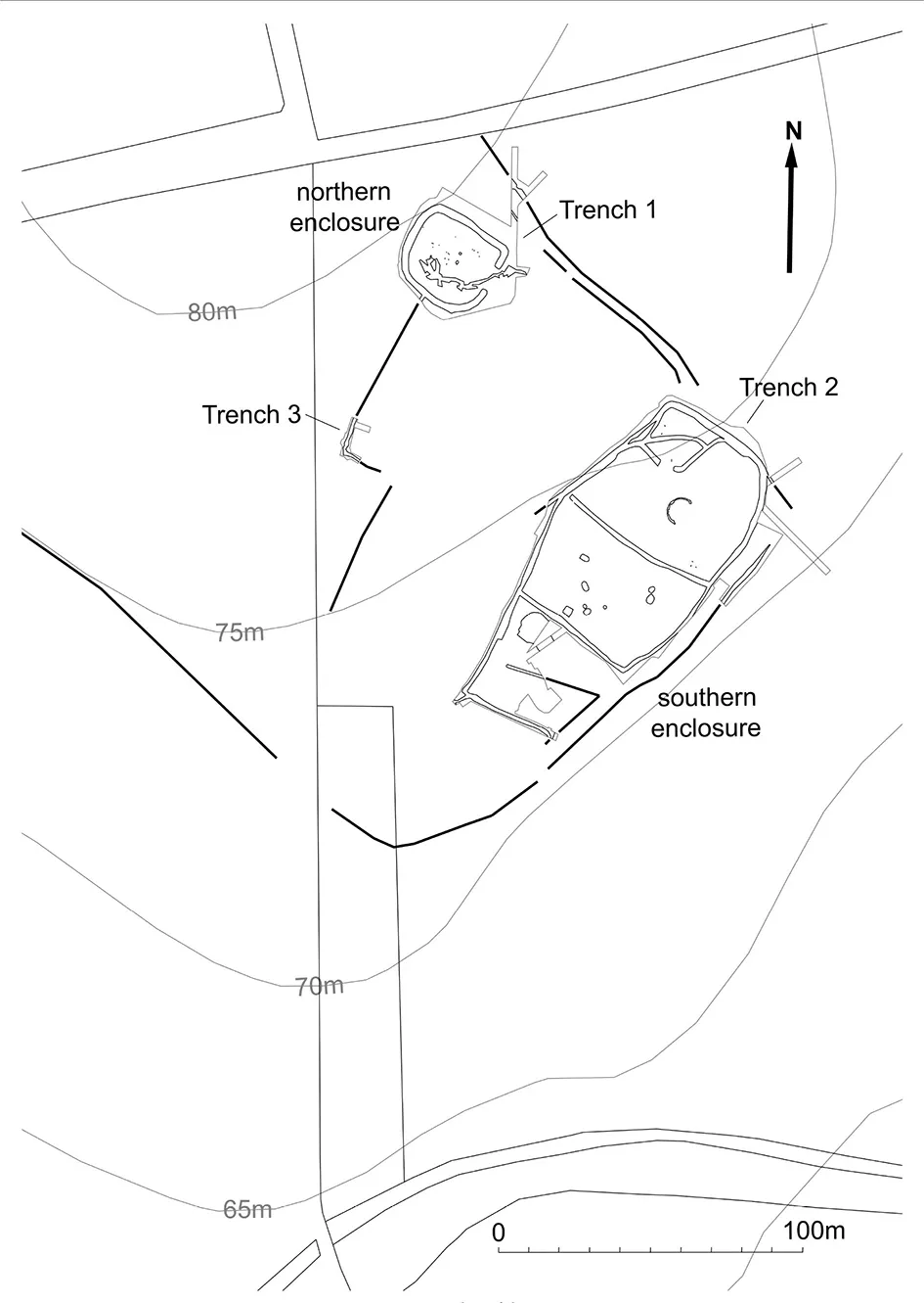
On the evidence of all these aerial photographs it was apparent that both the northern and southern enclosures sat within a curving cropmark, following the contours of the spur, the downslope line of which runs just to the south-east of the southern enclosure before bending round to the north-west and running into the adjacent field (see Fig. 1.3).
The excavations
The excavation project was initiated in 2005 as part of a programme of archaeological projects undertaken by Chichester District Council which ran from 2005 until 2010. The purpose of these projects was both to involve members of the public in archaeological projects and to inform the archaeological record.
The excavations were conducted over three seasons: in April 2005 the northern “banjo” enclosure was partially stripped of its ploughsoil and four sections were cut into its ditch; in August 2006 this northern enclosure was completely topsoil-stripped and the remaining sections excavated (Trench 1), together with a series of trial trenches over the “sub-rectangular enclosures” to the south; and in September 2008 the entire area of these southern enclosures was stripped of its topsoil and its features investigated (Trench 2), together with a small trench to the northwest over the parch mark of a ditch visible on the aerial photographs (Trench 3) (Fig. 1.3).
In all three seasons the same method was used to prepare the site for archaeological investigation. In advance of any of the public volunteers arriving on site, the topsoil was stripped down to the surface of the chalk using a mechanical excavator fitted with a toothless grading bucket under the supervision of the author. Excavations were then carried out by volunteers under the direction of the author and the supervision of Ken Mordle and John Wildman.
In May 2008 the Volunteer Archaeology Projects Trust was established in order to raise and supply funds for that year’s excavation and for the on-going post-excavation work, leading up to the publication of this final report.
Metal-detecting
During the course of the excavations, and in subsequent years, a small team of metal-detectorists, under the direction of Ken Mordle, has been active in the area of the site and over the wider Selhurst Park estate. All their findings have been reported to, and logged by, successive Portable Antiquities Scheme Finds Liaison Officers for Sussex, with the exception of those objects found by them during the course of the excavations themselves. Artefacts of an Iron Age or Roman date from the field within which the excavation site lies, and in the field immediately to the west, are reported on in chapter 4 alongside those from the excavations.
Figure 1.3 Plan of the site
Geophysical surveys
During the course of the 2006 excavation Andy Payne, of English Heritage (now Historic England), led a geophysical su rvey of part of the site, followed in 2010 by a further survey of areas to the south, led by Neville Haskins on behalf of Chichester District Council. Both of these are reported on in full in chapter 2.
![]()
2
The geophysical surveys
Neville Haskins and Andrew Payne
The 2006 survey
Introduction
During the second season of excavation at Middle Barn in 2006, English Heritage conducted a training exercise in geophysical survey with a team of some 13 volunteers from the Chichester District Archaeological Society (CDAS). The survey was undertaken over the area of the southern enclosure to provide information for future investigation at Selhurst Park and it was hoped that the volunteer training would enable the CDAS team to develop a capability to undertake further non-destructive research through geophysical survey to support its wider aims.
Over the course of the 4 days of training, practical tuition was provided in the use of fluxgate magnetometer, twin electrode earth resistance and differential Global Positioning System (GPS) survey techniques. Following the completion of the training, the initial magnetometer survey was expanded to the south with a further strip of 30 m grid squares by CDAS working independently.
The survey was carried out during a lengthy period of warm and dry weather with the occasional scattered shower. The site was under pasture at the time of the survey in 2006, but the area is also periodically under arable cultivation.
Method
The magnetometer survey was conducted using Geoscan FM36 fluxgate gradiometers over a grid of 30 m grid squares set out using a Trimble 4800 series GPS. Readings were recorded on the 0.1 nanotesla (nT) resolution setting of the instrument at 0.25 m intervals along successive parallel traverses aligned north south and spaced 1.0 m apart. Earth resistance data was recorded with a 1.0 m reading interval using a Geoscan RM15 resistance meter and a PA5 electrode frame in the Twin-Electrode configuration, with a mobile probe spacing of 0.5 m. The data collected by the volunteers was periodically downloaded and plotted on the screen of a portable computer using Geoplot version 3.0 to monitor progress and to display the data as the survey progressed.
Processing was carried out on the magnetometer data to selectively remove the strong localized magnetic effects of near surface iron objects by the use of a 1.5 m radius thresholding median filter (Scollar et al. 1990, 190–1) followed by the application of a frequency domain bandpass filter to remove periodic motion induced noise. The resulting magnetic data clarifies the main archaeological responses from buried ditches and is presented in the form of a greyscale plot in Figure 2.1.
Graphical summaries of significant geophysical anomalies discussed in the text are identified by the prefix ‘m’ on Figure 2.2 for the magnetic survey. Due to the variable quality of the data some caution has been applied to the interpretation of the results as the wide-scale presence of noise precludes overly detailed analysis of more tentative magnetic anomalies.
Results
Magnetometer survey
The magnetometer survey has clearly mapped the layout of the in-filled ditches defining the southern enclosure system as a series of positive linear magnetic anomalies (m1–5) with a maximum magnitude of 2.5 (nT). T...