![]()
1
Introduction
David Griffiths
Orkney: Landscape and history
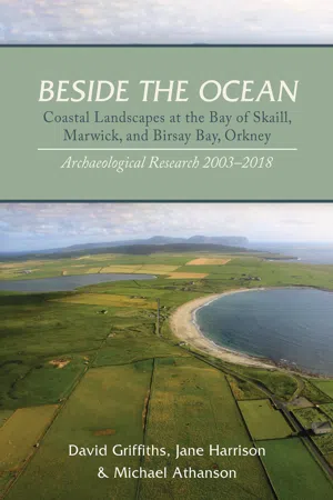
Orkney (or the Orkney Isles) is an archipelago off the north coast of Scotland (Fig. 1.1), with a population of c. 21,000 inhabiting 20 of around 70 islands and skerries. The topography of the central and largest island, Mainland (ON Hrossey, probably ‘Horse Island’), together with many of the outlying isles, is predominantly agricultural and rolling. The upper slopes of the hills and some inland bogs remain the province of heather and gorse, with peaty soils conferring a brownish, purplish hue contrasting with the lush green of the lower-lying farmland. On Orkney’s west-facing coasts, towering sandstone sea-cliffs meet the Atlantic, their wall interrupted by bays and inlets backed by areas of windblown sand, wetland and links. Towns and villages are few, and are mostly clustered around harbours, whereas farms and crofts are predominantly dispersed in the landscape.
Orkney has been inhabited since Mesolithic peoples moved north after the end of the last Ice Age. The remarkable floruit of Neolithic Orkney is seen in its exceptionally well-preserved ritual and funerary monuments, which are distributed throughout the islands, but occur in their greatest concentration along the spine of land between the inland Mainland lochs of Stenness and Harray, including the megalithic rings of Brodgar and Stenness, the spectacular chambered cairn of Maeshowe, and the complex of buildings and other structures on the Ness of Brodgar. Across the archipelago, Neolithic and Bronze Age cairns, brochs of the Iron Age, together with settlements of the Pictish, Viking and medieval periods, may be seen dotting the landscape, either as fenced, gated and signposted guardianship monuments, or (more numerously) as sandy, stony or grassy mounds and hummocks in fields, or perched above beaches. Some ancient sites underlie later buildings. Orcadian farmhouses and steadings are often replicated on much the same spot from generation to generation. It is not uncommon to pass by a farm where a modern double-glazed house stands next to an older stone one with cracked and cobwebbed windows, now in use as a shed or byre. Beside these might be a yet earlier tumbledown roofless drystone-built structure, once a dwelling, which serves today as an animal pen or is merely overgrown with nettles. In some cases, a cluster of farm buildings will appear to rise up out of the landscape upon a hillock, where the natural topography has been modified by centuries of human activity and the disposal of human and animal refuse. Settlement mounds (known in some accounts as ‘Farm Mounds’) are found throughout Orkney, most notably on Sanday and North Ronaldsay where the flat natural topography enhances their visual presence. Elsewhere, the patterns of deposition and surface creation which give rise to them are also present, but blend more invisibly into a naturally undulating landscape. Not all such mound sites remain inhabited. Centuries of climatic, economic and population change have seen the depopulation, settlement shift, abandonment, and in some cases reuse of earlier sites.
Dominated by ‘improved’ farmland delineated by ruler-straight roads and rectilinear fields divided by drystone dykes (walls), much of Orkney’s countryside is well-ordered and intensively-farmed. Orcadian agriculture is prodigiously productive, and its dairying, beef and whisky in particular are widely celebrated well beyond the isles. The primacy of these products confers a particular visual signature on the Orkney landscape, characterised by pasture, grass cropping, and barley fields with some continuing peat workings on the hillsides. The roots of improvement go back two centuries and more to the desire of the Lairds to harness a better return on their land, reaching its zenith when the industrial revolution transformed production, technology and society across Britain. The social and economic crisis caused by the price crash and sharp decline of kelp-making from around 1830 (Thomson 1983) prompted the most widespread and systematic re-drawing of the Orkney farming landscape, connecting settlements to new roads, mills, harbours and telegraphs. Two hundred years ago, there was considerable rural poverty. For poorer Orcadian folk, kelp-making provided a precarious and unenviable living; a grim, polluting, arduous process undertaken on and around the shoreline, the presence of which is yet marked by round, shallow, stone-lined pits about a metre in diameter. Inside these modest features, large quantities of wind-dried seaweed were burnt to create a residue of soda and iodine for export to industrial centres in Scotland and England. Kelping continued at the Bay of Skaill in 1858, given its role in the discovery of the Skaill Hoard (Chapter 21). Thereafter it waned yet further in importance as a source of income, although some small-scale sporadic kelp-burning continued into the first decades of the 20th century.
Fig. 1.1 Orkney, location of project area © Crown Copyright 2018. An Ordnance Survey/EDINA supplied service
Large-scale improvement got under way between the first and second productions of a nationwide inventory known as the ‘Statistical Account of Scotland’, a parish-by-parish survey written by kirk ministers in response to standard questions about geography, population and agriculture. These subsequently became widely known as the ‘Old’ Statistical Account or OSA of 1790–95, and the ‘New’ Statistical Account or NSA of 1834–45. The ‘improvement’ period of the 1830s saw the first systematic measured maps made in order to plan the Orkney landscape (e.g. Fig. 2.6). Prior to this, sea charts, beginning with the Dutch surveyor Joannes Blaeu’s 1654 map of Orkney and Shetland, Murdoch Mackenzie’s charts of the mid-18th century, and antiquarian artistic depictions, gave but a glimpse of the landscape (e.g. Figs 2.1 and 2.2). The first Ordnance Survey map editions covering the area at 25 and 6 inches to 1 mile were published in 1882, only after which we have a more consistent cartographic record.
The pre-improvement landscape remains to some extent visible in those areas that preserve a pattern of smaller, less obviously planned and re-drawn infields and landholdings. Its legacy is also preserved in the place-names of the islands. Orkney’s geography and everyday language are freighted with Old Norse-derived terms, many of which refer to topographical features, such as –a, –ay or –ey (øy – ‘island’), –wick (–vik –‘bay’), –ness (–nes – ‘headland’) or Howe (haugr – ‘mound’). From the earldom farms named in Bu (bý), and the significant district head farms named in Skaill (skáli), to the medium-ranking ones in Garth (garðr); Stove (stofa); –bister (bólstaðr); and –ston or –sta (staðir), and the comparatively minor or outlying –quoy (–kví) and –setter (sætr), Orkney place-names convey a complex picture of past settlement hierarchy, land-use and expansion, the chronology and extent of which continues to be fiercely debated. The majority of Orkney’s Scandinavian place-names have survived and been adapted throughout the last five centuries of Scots and English linguistic influence. As such, they provide a link to the Norse or Norn-speaking centuries of the Earldom of Orkney, although the precise date of their origin is in most cases hard to prove. An identification of the imprint of Scandinavian place-names on the Orkney landscape with the earliest Viking presence (often almost uncritically termed the ‘Viking take-over’) is becoming harder and harder to sustain. Favoured by the historians of the early to mid-20th century, the extent of early Viking cultural dominance is now being questioned in many different ways. A more recent generation of historical writers, exemplified by William Thomson, have stressed the long timescales and nuanced local patterns of naming and landscape development, seeing many apparently ‘Viking’ innovations in the landscape not as the direct result of violent conquest in the 8th or 9th centuries, but as products of ongoing cultural influence, within and outwith Orkney, in the 10th, 11th and 12th centuries, and even later (e.g. Thomson 1995a).
A major problem in attempting to assert the chronology and extent of early historic influences on the landscape is that few surviving documentary sources for Orkney pre-date the impignoration or transfer of sovereignty of the Northern Isles from the Danish to the Scottish Crowns in 1468–71. The Earldom of Orkney, which at its height in the 13th century encompassed Shetland and Caithness as well as the Orkney archipelago itself, was a semi-independent fiefdom originally associated with Norway (and after the Kalmar Union of 1397, Denmark). Linguistic and historical sources for the history of the earldom have been described in many recent publications, which it would be superfluous to repeat here (e.g. Crawford 1987; Thomson 2008; Crawford 2013). The pre-Scottish historical record for Orkney is dominated by one source above all, which has influenced every aspect of historical thinking about the islands beyond measure. Orkneyinga Saga, a conflation of writings originally known as Jarl’s Saga which were composed in Iceland around 1200, contains a history and genealogy of the earls of Orkney, and much colourful and spectacular detail on the struggles for power in the Northern Isles. It purports to record that the earldom began in the mid-9th century AD, with a legendary voyage and visit of Harald Fairhair of Norway who gifted the islands to Earl Rognvald of Møre who then passed them on to his brother Sigurd, whom the Saga names as the first Earl of Orkney. Coinciding with the age of Viking attacks across the Irish and North seas, this date is superficially an attractive one for those who would see the Orkney earldom as a straightforward ‘colonial’ expression of early Scandinavian westward territorial expansion. Some Viking presence in the Northern Isles at this time undoubtedly there was. However, much of Orkneyinga Saga’s most detailed and praise-laden coverage is concerned with the lives and exploits of leading personalities, notably in the period 975–1065, which Barbara Crawford calls ‘The Age of the Earls’. Two key figures dominated this period: Sigurd II ‘The Stout’ (c. 985–1014) who fought and died at the Battle of Clontarf in Ireland, and his son Thorfinn ‘The Mighty’ (d. 1064), who oversaw the Christianisation of the islands, founded the bishopric and Christ Church at Birsay, and consolidated the earldom as a powerful and durable political entity. Given the propensity of Icelandic saga-writers to ‘rewrite history’ to embellish the achievements of the ancestors of their own patrons, it is possible to caution that the accepted chronology of the achievements of the earldom prior to AD 985 is a mixture of fact and fantasy resting on the sparsest of historical foundations. The full impact of Scandinavian culture in Orkney cannot be comprehensively documented for prior to the mid-10th century. By converting claim and legend into historical reality, and therefore artificially ‘back-dating’ a picture of full established control by the Norwegian earls by at least a century, ‘Saga-History’ has made it more difficult to envisage a subtler, intermediate phase involving a limited Scandinavian presence with locally-based leaders who oversaw interaction with existing populations, but perhaps did not exercise overall dominance, between the later 8th and mid-10th centuries.
The last Norwegian earl died in 1231, when the earldom title passed by inheritance into a succession of Scottish lineages: Angus, Stratherne, Sinclair and Stewart, ending with the execution of the last of the Stewart earls, Patrick, in 1615. The Sinclair and Stewart periods provided one of the most important historical groups of sources for later medieval and early post-medieval Orkney in the form of the rental assessments of 1492 (Thomson 1996), 1500 and 1595 (Peterkin 1820). The compiler of the 1492 and 1500 rentals, Lord Henry Sinclair, had inherited the lease or ‘tack’ of the earldom estates from his grandfather William Sinclair, who was earl from 1434 to 1470. Given the degree of continuity of landed authority at a local level, and the apparent lack of any dispute or hostility surrounding the transfer from Denmark to Scotland, it is hardly surprising that the institutions and conventions of later Scandinavian landholding passed almost unchanged into the period of Scottish sovereignty. The taxes or ‘skats’ maintained their earlier character – butter skat (which did not merely include butter); malt skat; ‘forecop’; and ‘wattle’ which derived from the Old Norse viezla or obligation to provide hospitality to the lord. ‘Ley’ referred to skat, which continued to be levied on untenanted or abandoned land. Orkney remained divided into Earldom, Bishopric and Udal or freehold taxable land. Bishopric land, which included Birsay, was not included in the 1492 or 1500 rentals. Pennylands, which approximated to one farm, formed the basic unit of taxable land assessment, eighteen of which counted as an Ounceland (or ‘Urisland’). Townships were sub-parish units, fundamental to the distribution of agricultural land types between households, which occurred with varying multiples of pennyland values. As with the majority of place-names, it is less than clear how far back in time prior to their occurrence in written record that these land apportionments may be taken chronologically. The view popular amongst an earlier generation of historians, that they represent an unchanged inheritance from the Viking period, has been refuted in recent years.
Thomson’s most recent account preferred the 12th century as the period when this system crystallised across Orkney (Thomson 2008). In his preface to his translation of the 1492 rental, Thomson cautions: ‘rentals ought not to be regarded as describing a system which stretched back virtually unchanged to the days of King Harald Fairhair, as was at one time supposed’ (Thomson 1996, vii). The documented form of 15th-century Orkney landholding is clearly later medieval in character, and the boundaries may have been revised numerous times before 1492, in particular through subdivision. However, there are hints in the values of different townships of older, simpler, land divisions that may help us to interpret patterns of landholding and settlement in earlier times (below, Chapter 25).
With a relative dearth of pre-15th century accurate historical information to hand, runic inscriptions can assist in the search for location, status and power amongst the settlements of Norse Orkney. With the exception of the splendid series of thirty inscriptions in the interior of Maeshowe (Barnes 1994), few of these express more than a few letters of words of relatively abstruse personal (or in some cases purely devotional) meaning. Moreover, many which were carved on stone are no longer in their origin...