![]()
1. Area C, the east gate
Andrew Poulter
Introduction
The location of the east gate was readily identifiable before excavations commenced. From the base of the hill a track-way, revetted into the side of the steep eastern slope, ascended to the summit where it met the west/east street (street 1). In the first year of fieldwork (1996), an area 12m north/south and 8.0m east/west was laid out and excavation began. In 1997, excavation continued through the Period 3 occupation level down to the Period 1 prehistoric soil. In 1998, the area was extended south by 4.0m to investigate the upstanding remains of the curtain-wall and the ascensus which was found to abut its northern, internal face. Work in this area was concluded after a final redrawing of the sections in 1999.
Period 1
A black/brown humic clay deposit (52097) extended across the entire area and was cut by the foundations for the curtain-wall (Fig. 1.1). Its contents included copious fragments of late Bronze Age and early Iron Age pottery, which suggests that the soil had been disturbed before the fort was built, presumably by cultivation. With the possible exception of the hand-made spindle whorl (SF720), metal finds recorded as coming from this deposit were probably intrusive and came from the dump deposits which directly overlay it.1
Uniquely, the lowest level of the Period 3 demolition deposit (52132 and 52127) contained, not only residual prehistoric sherds, but also crushed Roman red wares and brick fragments (Fig. 1.1). Too small to be closely dated, the pottery must be earlier than 400 but is most probably 2nd/3rd century in date.2 Moreover, within the core of the tower wall, broken brick fragments were reused; surely salvaged from a Roman occupation deposit (Fig. 1.2).3 Within the gateway a massive limestone block (52016) must have come from a monumental Roman structure (Fig. 1.8). It measured 1.36m in length and was square in profile (0.66m × 0.66m), cut by two Lewis holes for raising the stone into position. Together, these finds indicate that the site had been occupied in the Roman Period, before the fort was built, but that its use had been limited; no structural remains in situ, predating the late Roman fort, have been found during the excavations.4
Period 2
Excavation uncovered the surviving remains of a section of curtain-wall (52040), the gateway together with the upstanding portion of its northern side (52035), which were of one build with the southern side of a rectangular tower (Figs 1.3 and 1.4). To the south of the gate, the curtain-wall was abutted, on its inside face, by a staircase (ascensus) (52039), providing access to the wall-walk.
South of the gate, the upstanding portion of the curtain-wall (52040), 0.90m high and 1.80m wide, had a solid core of sandstone blocks, bonded with white mortar and stood four courses high, faced with regularly shaped sandstone blocks (each c. 0.40m long and c. 0.10m wide), above a deep foundation of mortar and roughly cut blocks of sandstone (Fig. 1.2).5 A rectangular extension to the foundation (1.0m × 0.80m) was bonded with the curtain-wall, projecting to the west and inside the fortified area (Fig. 1.3). The function of this addition, part of the original design for the wall, must have been to anchor the curtain more firmly into the side of the hill, above the precipitous slope which plunged sharply down to the base of the hill, immediately to the east of the gate (Fig. 0.3).6
Abutting the inside face of the wall (and built around the buttress), a second portion of superstructure (52039), still stood 0.80m above its foundations, its inner western side faced with regularly spaced sandstone ashlars, bonded with the same white mortar which was used in the construction of the curtain-wall (Fig. 1.5). The foundation, which was 1.70m wide, was traced for 5m before it, and the remains of the curtain-wall (52040), entered the baulk, continuing beyond the southern limit of the excavation (Fig. 1.3). Its foundation trench cut the Period 1 soil and the internal mortared face butted close up against the western side of the cut. This structure supported a staircase (ascensus), no doubt built immediately after the erection of the curtain (52040), and as part of the original design. The location of the first three steps is clearly visible at its northern end leading up from the gate entrance (Figs 1.3, 1.4 and 1.5). Each step must have been formed by placing stone blocks upon the mortared substructure.7 Because the full length of the stairway was not excavated, it is not possible here to determine the full height of the curtain. Where the full length of foundations for another ascensus were identified on the western side of the circuit (area F), the slabs which formed the steps were in situ and the angle of ascent could be estimated, proving that the wall-walk must have been c. 9.50m above the contemporary ground surface.8 The same was probably true for the curtain-wall on either side of the gate.
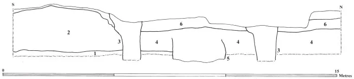
Fig. 1.1A. The west section, Area C.
Fig. 1.1B. Interpretation of the western section, area C. 1, Soil level, Period 1. 2, The mudbrick demolition deposit (Period 3). 3, Robber-trenches. 4, Make-up deposits for Period 3 surface. 5, Rectangular pit cut during the reconstruction of the site (Period 3). 6, Occupation level covered by robbing material (Period 4).
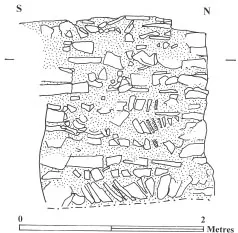
Fig. 1.2. Elevation across the surviving, south side of the tower, Area C.
The curtain-wall foundation continued north beneath the gateway and bonded with a short section of surviving curtain (52035) which was of one build with the southern side of a rectangular tower (Fig. 1.3). Within the gateway, responds, on each side of its outer face, must have supported the springing of an arch over the entrance and would have protected the pivot sockets for two wings of a timber door, narrowing the eastern, outer entrance to 1.70m. To the rear, the full width of the gate-chamber measured 2.40m.
The back wall of the tower (52045) was only 1.20m wide, appreciably narrower than the southern wall (52035) which was 1.75m thick (Fig. 1.3). Although completely robbed out, it is likely that the eastern and northern sides of the tower matched the strength of the preserved southern tower wall which was 1.80m wide (Fig. 1.2).9 It presumably had at least two upper floors; its foundations were in excess of 1.70m deep.10 Although the tower walls had been completely robbed on its northern and eastern sides, their location was defined by the deep robber-trench which had removed all but the stub of its southern wall. The tower must have measured c. 5m north/south and c. 5.5m west/east. Both in detail (the narrower inside wall) and in plan, the tower mirrored the design of another tower (area E) on the western side of the defences; it also straddled the curtain-wall, projecting both beyond the defences and extending back into the fortified area. The internal clay make-up for the floor of the tower (52043) survived intact, covered by a partially preserved mortar layer. The tower internally measured 2.70m north/south and 2.0m west/east. Two flat stones lay on this compacted surface: proof that the tower originally had a slabbed floor, although most of the stones had been removed before the area was back-filled with demolition material at the beginning of Period 3 (Fig. 1.3).11 The southern side of the tower stood to a height of 0.70m and was internally plastered and rendered in imitation of ashlar masonry.
Evidently, the gate, curtain-wall, the ascensus and the tower were all built as parts of the same original plan. To the south of the area, a robber-trench follows the line of the curtain-wall as far as the south-eastern corner tower (Fig. 0.3).12 To the north, the curtain wall must have continued slightly below the modern crest of the hill, almost as far as the north-eastern corner, where a short length of robber-trench on the edge of the summit denotes its course.13
There was a drain (52065) beneath the gate, built from mortared blocks (0.22–0.45m in length and 0.25m thick). It stood two courses high (0.15m) and was 0.25m in width (Fig. 1.3). Immediately inside the gate, two limestone slabs (52041 and 52066) remained in situ, covering the channel. East of the gate, another section (52065) survived where it changed direction and headed north-east past the tower (Fig. 1.3). No other traces of the drain were excavated to the west, although, since it certainly functioned in Period 2, it must have continued up the slope and into the site.
Period 3
West of the ascensus, the relationship between Period 1 and the overlying Period 3 demolition deposit was particularly clear (Fig. 1.1). However, unexpectedly, there was no sign of a primary occupation surface for Period 2. Instead, the Period 1 soil formed an even but uncompacted level, immediately overlain by the demolition deposit of mudbrick (52092), dumped behind the ascensus at the beginning of Period 3. The same lack of a compacted surface was true for th...