A Guide for Urban Designers, Architects and Town Planners
Jonathan Tarbatt, Chloe Street Tarbatt
This is a test
This is a test
Compartir libro
160 páginas
English
ePUB (apto para móviles)
Disponible en iOS y Android
eBook - ePub
The Urban Block
A Guide for Urban Designers, Architects and Town Planners
Jonathan Tarbatt, Chloe Street Tarbatt
Detalles del libro
Vista previa del libro
Índice
Citas
Información del libro
The block is no more than the land and building area defined by streets. It is the nature of the interface between the two, which has a critical impact on the quality of the spaces between those buildings. The importance of the block to city life is well rehearsed, and in any case, we seldom find ourselves in the business of making cities from scratch. But we are in the business of making new houses, neighbourhoods and new local centres, and we need lots of them: 250, 000 a year to be imprecise. Against the background of a burgeoning housing shortage in the UK, there are varied issues to be reconciled. The Urban Block charts the fall and rise of the perimeter block as the staple of urban form and structure from ancient times. It takes you through the process of understanding, defining, structuring and designing the block. Carefully selected urban and suburban case examples explain "do's and don'ts" of good block layout and will help you to produce better masterplans, while staying in touch with commercial realities.
Preguntas frecuentes
¿Cómo cancelo mi suscripción?
Simplemente, dirígete a la sección ajustes de la cuenta y haz clic en «Cancelar suscripción». Así de sencillo. Después de cancelar tu suscripción, esta permanecerá activa el tiempo restante que hayas pagado. Obtén más información aquí.
¿Cómo descargo los libros?
Por el momento, todos nuestros libros ePub adaptables a dispositivos móviles se pueden descargar a través de la aplicación. La mayor parte de nuestros PDF también se puede descargar y ya estamos trabajando para que el resto también sea descargable. Obtén más información aquí.
¿En qué se diferencian los planes de precios?
Ambos planes te permiten acceder por completo a la biblioteca y a todas las funciones de Perlego. Las únicas diferencias son el precio y el período de suscripción: con el plan anual ahorrarás en torno a un 30 % en comparación con 12 meses de un plan mensual.
¿Qué es Perlego?
Somos un servicio de suscripción de libros de texto en línea que te permite acceder a toda una biblioteca en línea por menos de lo que cuesta un libro al mes. Con más de un millón de libros sobre más de 1000 categorías, ¡tenemos todo lo que necesitas! Obtén más información aquí.
¿Perlego ofrece la función de texto a voz?
Busca el símbolo de lectura en voz alta en tu próximo libro para ver si puedes escucharlo. La herramienta de lectura en voz alta lee el texto en voz alta por ti, resaltando el texto a medida que se lee. Puedes pausarla, acelerarla y ralentizarla. Obtén más información aquí.
¿Es The Urban Block un PDF/ePUB en línea?
Sí, puedes acceder a The Urban Block de Jonathan Tarbatt, Chloe Street Tarbatt en formato PDF o ePUB, así como a otros libros populares de Architektur y Architektur Allgemein. Tenemos más de un millón de libros disponibles en nuestro catálogo para que explores.
Understanding the history of urban form, and particularly the urban block, is essential to understanding the urban context within which we are designing today. Without an understanding of what works and why, we cannot hope to exert a positive influence on the urban fabric. Following this premise, this chapter outlines a short history of urban form, explaining how certain historical processes have affected patterns of urban development and consequently, the formation of urban blocks.
THE BLOCK, THE PLOT AND THE STREET
The traditional urban block cannot be understood as a discrete entity. Rather it is one element of a system that depends both on its symbiotic relationship to the street and on the substrate of subdivisions that divide it into smaller, more or less independent units of land holding known as plots or lots. In turn, these plots can be occupied by different buildings and potentially have different uses or combinations of uses. This underlying structure implies a ‘built in’ capacity for change, for which the plot is the underlying framework. As Panerai et al. put it: ‘To think of the block as a whole would be missing the point, and reducing it to a continuous and homogeneous built up area surrounding an empty centre…risks showing the outward appearance of urbanity without ensuring the conditions that allow it to happen.’1 Put simply, the fabric of older towns and cities has evolved through this superimposition of several structures operating at different scales to produce different yet coherent urban forms.
This historic practice, to masterplan by plot and block together, where the owner of every plot is left to their own devices, has been superseded in the modern era by a tendency to masterplan by block alone, where the block is produced by the space left over after the street has been defined, and each block or series of blocks is developed by a single entity (the developers). Contemporary masterplanning practice tends to reduce the block to a single ‘super plot’ to be occupied by a single building (or sometimes a group of buildings which are nonetheless ‘joined at the hip’ by means of a shared basement or podium). In this new normal, the plot is no longer part of the development equation, and so an invisible yet fundamental structuring element of the ‘old town’ has been removed. Once this is understood, we can begin to understand why historic blocks have managed to evolve and change to meet new conditions, and why modern blocks are more likely to be replaced in their entirety when they are no longer fit for purpose.
THE BLOCK IN ANTIQUITY
This potted history begins around the turn of the common era (CE) at the outset of the Roman Empire, during which the significant term ‘insula’ (plural ‘insulae’), meaning ‘island’, was coined to denote both an apartment building and an urban block. The term ‘island’ is instructive because the block takes its form from the streets that surround it. In other words, it is the area of private land surrounded by public streets. Gates3 estimates that 90% of the population of Ancient Rome lived in insulae, and as such, they constituted the general fabric of the city, punctuated by shops, public buildings and more salubrious villas. To form an ‘island’ requires more than one street. This essentially differentiates the block, which sits within a network of streets, from the linear nature of streets on their own: the street must change direction more than once for a block to be formed. Second, one ‘island’ on its own does not a city make.
The Ancient Greeks are credited with the rational masterplanning of new cities in orthogonal grid patterns at least four centuries earlier than this, during the late classical period of the 5th and 4th centuries BCE (e.g. Miletus, Piraeus, Olynthos and Priene). Describing excavated Greek houses at ancient Olynthos, for example, Gates4 states: ‘Blocks of adjacent houses sharing walls are neatly arranged along straight streets, laid out in parallel lines. Houses are similarly hidden from the street by an enclosure wall, and inside, the courtyard is the focus.’5 Parallel to the gridded masterplans taking place in classical Greece, such layouts were emerging elsewhere, with similar examples found in Babylon (present-day Iraq).
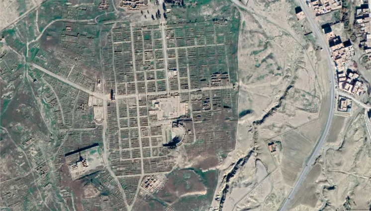
This gridded approach developed by the Ancient Greeks and other early civilisations was highly influential on Roman city planners (e.g. Timgad, North Africa; see Figure 1.1), who continued the practice as part of a ritualistic process, culminating in the distribution of building plots by lottery.6 Although Timgad seems a somewhat random case – isolated as it is in the barren landscape of North Africa – its function as a garrison town is very much representative of a formula that was established for new fort towns across Africa, Gaul and Britain during the Roman Empire, and illustrates the far-reaching and long-lasting effects of classically inspired Roman town planning.
1.1 Aerial view of the Roman City of Timgad,2 Algeria, dating to the 1st century BCE. The blocks, or ‘insulae’, measure approximately 21m2.
There are two relevant points that arise from these early examples of gridded masterplanning. Firstly, that the practice of creating a masterplan that defines urban blocks has a long history, and secondly, that these blocks were (at least initially) occupied by internally oriented courtyard houses, and as such did not address the streets that they enclosed.
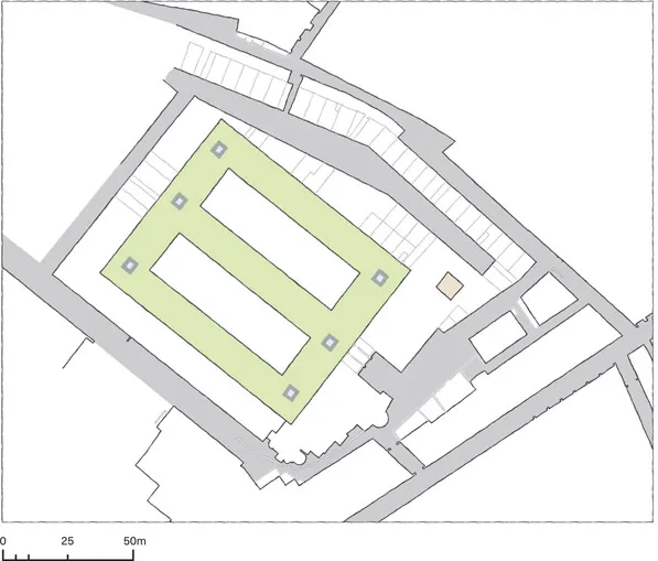
This relationship to the street appears to have been fundamentally altered by later Roman city building. Urban remains at the mercantile Roman city of Ostia have been relatively well preserved and the archaeological excavations of four-storey insulae dating to the 3rd century BCE7 show an urban form we can more readily associate with contemporary urban blocks (see Figure 1.2). The excavated block at Ostia is lined with shops at street level, with a series of passages and entrances leading to apartments overlooking the public street and a garden courtyard. The interior of the block contains shared open space with two further apartment blocks, and as such, creates what we define as a ‘nested perimeter block’.
1.2 A mixed-use block of apartments and shops, Ostia.
THE MEDIEVAL BLOCK
A new phase of urban development took place during the medieval period, between the 10th and 11th centuries CE, during which the political and economic climate in Europe regained some semblance of stability. The direct corollary of the masterplanned city of the Greeks and Romans (whether gridded or adopting a radial or other pattern) is the unplanned, seemingly ‘organic’ one, which is most commonly associated with the medieval towns developed during this period. As Spiro Kostof8 argues in The City Shaped: Urban Patterns and Meanings Through History, this apparent dichotomy is problematic. What reads as unordered may on closer examination prove to be an ‘irregular pattern’. Rather than being ‘unplanned’, it is more accurate to suggest that such forms resulted from the accumulated decisions of a greater number of agents over a longer period of time. It is also well documented that ‘new’ medieval towns (i.e. ones that did not inherit a pre-existing urban form) were often laid out by surveyors, albeit on occasion not very accurate ones.9 Because medieval land division was fixed with reference to metes and bounds (natural features or pre-urban land divisions and pathways), as well as with the use of instruments, it is not surprising that the results would yield seemingly organic forms, which contrast with the more orderly gridded masterplans of both earlier and subsequent eras.
Understanding the historical forces that brought these organic-seeming urban forms into being helps to explain the diversity of block formation that emerged during this medieval period.
According to Hindle10 there are five types of medieval plan layouts found in Britain:
Towns with central marketplaces (usually triangular owing to the meeting of three roads).
Linear towns (usually a street with a widening to accommodate a marketplace).
Castle towns (often consisting of a single street running from the castle gates and surrounded by a protective ditch or wall).
Rectilinear plans (planned towns with a rectilinear block pattern, extending to a few examples with gridded plans consisting of more than twelve rectilinear blocks).
Composite plans (plans that grew in different ways over time, for example organic in origin with planned extensions or alternatively planned cores with ad hoc extensions).
Elsewhere, in the later medieval period, bastide towns – established in Southern France, Northern Spain, the Netherlands and Wales – took on a more deliberately gridded arrangement. The more orderly form of these settlements can be read as an expression of control by wealthy nobles over land for farming, trade and defence over contested territories.11
Together these illustrate the complexity of urban morphology as an area of study, serving to highlight some of the factors that challenge the conventional assumption that the block is either the result of a rational masterplan (i.e. gridded) or the result of happenstance (i.e. organic). Rather the history of urban form is multilayered, with places being subject to multiple influences over time. Where a block layout originally formed as the result of a gridded masterplan, this order may also be disrupted by later occupiers. For example, the Roman grid is outward-related but the Islamic ‘block’ is inward-looking, and so Roman gridded towns that were taken over by Muslim invaders were re-moulded to suit the cultural and religious norms of Islam. Different processes disrupted the grid in the West, for example the primacy of the marketplace was asserted over and above the Roman forum and asserted a radial hierarchy of movement for which the grid is not so well suited.12
One such city is London. Within the Roman city walls the primary streets maintained their original alignments...