Rifted margins mark the transition between continents and oceans, which are the two first-order types of land masses on Earth. Rifted margins contribute to our understanding of lithospheric extensional processes and are studied by various disciplines of Earth Science (geology, geophysics, geochemistry). Thanks to better and wider public access to high-quality data, our understanding in these areas has improved significantly over these last two decades. This book summarizes this knowledge evolution and details where we stand today, with a series of case examples included. It is structured in a practical way, with concise text descriptions and comprehensive diagrams. Continental Rifted Margins 2 is a useful resource for students and newcomers to the rifted margin community – a "cookbook" of sorts to facilitate the reading of scientific publications and provide basic definitions and explanations.
Preguntas frecuentes
¿Cómo cancelo mi suscripción?
Simplemente, dirígete a la sección ajustes de la cuenta y haz clic en «Cancelar suscripción». Así de sencillo. Después de cancelar tu suscripción, esta permanecerá activa el tiempo restante que hayas pagado. Obtén más información aquí.
¿Cómo descargo los libros?
Por el momento, todos nuestros libros ePub adaptables a dispositivos móviles se pueden descargar a través de la aplicación. La mayor parte de nuestros PDF también se puede descargar y ya estamos trabajando para que el resto también sea descargable. Obtén más información aquí.
¿En qué se diferencian los planes de precios?
Ambos planes te permiten acceder por completo a la biblioteca y a todas las funciones de Perlego. Las únicas diferencias son el precio y el período de suscripción: con el plan anual ahorrarás en torno a un 30 % en comparación con 12 meses de un plan mensual.
¿Qué es Perlego?
Somos un servicio de suscripción de libros de texto en línea que te permite acceder a toda una biblioteca en línea por menos de lo que cuesta un libro al mes. Con más de un millón de libros sobre más de 1000 categorías, ¡tenemos todo lo que necesitas! Obtén más información aquí.
¿Perlego ofrece la función de texto a voz?
Busca el símbolo de lectura en voz alta en tu próximo libro para ver si puedes escucharlo. La herramienta de lectura en voz alta lee el texto en voz alta por ti, resaltando el texto a medida que se lee. Puedes pausarla, acelerarla y ralentizarla. Obtén más información aquí.
¿Es Continental Rifted Margins 2 un PDF/ePUB en línea?
Sí, puedes acceder a Continental Rifted Margins 2 de Gwenn Peron-Pinvidic en formato PDF o ePUB, así como a otros libros populares de Physical Sciences y Geophysics. Tenemos más de un millón de libros disponibles en nuestro catálogo para que explores.
1 The West Iberian Margin: Past and Current Research Concepts and Future Challenges
Gaël LYMER1 and Tim J. RESTON2
1 Fault Analysis Group/iCRAG (Irish Centre for Research in Applied Geosciences), School of Earth Sciences, University College Dublin, Ireland
2 School of Geography, Earth and Environmental Science, University of Birmingham, UK
The West Iberian Margin has historically been at the forefront of fundamental research on rifting and breakup. Decades of drilling, sampling and geophysical campaigns, including a recent high-resolution 3D seismic volume, have placed the West Iberian Margin among the best-documented continental margins worldwide. Data from the West Iberian Margin allowed initial development of the concepts of hyper-extension, detachment faulting, “undercrusting” by serpentinites and exhumed mantle rocks. Above all, they have revolutionized our modern scientific concepts of rifting by allowing us to demonstrate that the rifting process is diachronous across margins and involves the migration and/or the focusing of extension towards the future oceanic spreading center during rift evolution. These concepts resulted in the early theories about the processes of oceanic basin development and still contribute to defining the latest models of continental breakup. Three major models of continental breakup have been defined from observations at the West Iberian Margin: depth-dependent stretching (DDS), cross-cutting polyphase faulting and sequential faulting. The fundamental disparities between these models – in terms of the timing of faulting, the number of faulting phases and rheologies – demonstrate that our knowledge of rifting and breakup remains fundamentally incomplete, as long as the timing of geological events at rifted margins remains undefined.
In this chapter, we summarize the historical investigation of the West Iberian Margin and the current geological knowledge on the features formed during their rift evolution and breakup. We present an overview of their structures and litho-stratigraphy, and the latest ideas for their evolution, highlighting the key remaining questions, how they might be addressed and why answering these questions would represent a paradigm shift in our knowledge of the concepts of development of rifted margins worldwide.
1.1. Introduction: the West Iberian Margin, the “classic” magma-poor margin?
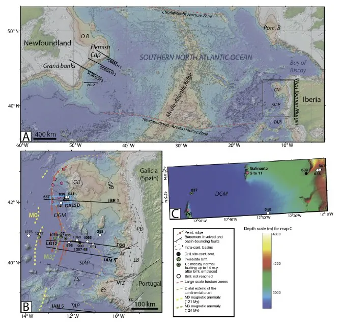
The West Iberian Margin (WIM) is the rifted margin marking the western edge of the Iberian Peninsula (Figure 1.1). It includes three main segments: the Galicia Margin (GM) in the north, the South Iberia Abyssal Plain (SIAP) and the Tagus Abyssal Plain (TAP) in the south. From land to sea, the GM comprises a narrow continental shelf, bounded to the west by the Galicia Interior Basin (GIB), the Galicia Bank (BG) and the Deep Galicia Margin (DGM), where the smooth seafloor is locally marked by local ridges (Figure 1.1b and 1.1c). To the south, the continental shelf includes intra-continental basins (Porto and Lusitania basins – PB and LB), bounded to the west by the SIAP showing a smooth and relatively flat seafloor. Finally, the southern segment of the WIM is marked by the Estramadura Spur (ES) and the Tore Seamounts (TS) that form the northern boundary of the TAP. The segmentation of the margin has been related to the south to north propagation of the North Atlantic rifting and crustal breakup (e.g. Brune et al. 2014; Srivastava et al. 1990; Malod and Mauffret 1990; Tucholke et al. 2007; Brune et al. 2014), favored by orthogonal fractures (AF, NFZ, TF on Figure 1.1), either considered to be inherited from Late Hercynian fabric (e.g. Boillot and Malod 1988; Manatschal et al. 2015) or to have developed during a Late Triassic–Early Jurassic phase of rifting (e.g. Vegas et al. 2016).
While the thinned continental crust is still relatively thick at the GIB/GB (≥10 km, although locally ~8 km at the center of the GIB, e.g. Reston 2005; Peron-Pinvidic et al. 2013; Druet et al. 2018) and at the PB/LB (Figure 1.2), the continental crust at the DGM, SIAP and TAP has been hyper-thinned to less than 5–10 km during rifting (e.g. Pérez-Gussinyé and Reston 2001; Lymer et al. 2019). Where hyper-thinned, the crust exhibits arrays of tilted fault blocks below a thin sedimentary cover (Figures 1.3 and 1.4), but the observed thinning greatly outstrips the amount of extension inferred from fault geometries (Ziegler 1983; Sibuet 1992; Davis and Kusznir 2004, pp. 92–136; Reston et al. 2007; Reston 2009; Figure 1.5). This problem, known as extensional discrepancy (Reston et al. 2007; Reston 2009), has been explained by distinct models involving different fault geometries and timing of fault activity to describe the rift evolution of the margin (see section 1.4). Beneath the hyper-thinned crust (Figures 1.3 and 1.4), the mantle with reduced seismic velocity (Figure 1.2) has been interpreted, but not yet proven, as being partially serpentinized, “undercrusting” the hyper-extended domain (Boillot et al. 1989; Whitmarsh et al. 2001; Bayrakci et al. 2016; Davy et al. 2016). This subcrustal layer is thought to form when the entire crust becomes brittle as a result of the ingress of seawater from above, through the thinned continental crust (Pérez-Gussinyé and Reston 2001; Bayrakci et al. 2016; Prada et al. 2017), and seems to continue beyond the distal edge of the crust (Figure 1.1, green drill sites, and Figure 1.2) as an expanse of partially serpentinized mantle, locally exhumed to the seafloor during the final stages of rifting (e.g. Boillot et al. 1987; Krawczyk et al. 1996; see Peridotite Ridges in Figure 1.1). The boundary between the hyper-extended crust and the underlying serpentinized mantle corresponds at the DGM to a set of bright reflections forming a major detachment surface known as the S reflector (Figure 1.3; e.g., Krawczyk et al. 1996; Reston et al. 2007; Schuba et al. 2018; Lymer et al. 2019). West of the exhumed mantle domain, the location of the transition to the oceanic domain remains debated (e.g. Sibuet et al. 2007; Welford et al. 2010; Peron-Pinvidic et al. 2013). Oceanic crust is commonly identified based on the presence of seafloor-spreading magnetic anomalies (e.g. Eagles et al. 2015), with the use of the oldest isochrons to define the approximate landward limit of the oceanic domain, but magnetic anomalies have also been observed within exhumed mantle or hyper-extended continental crust (Whitmarsh and Miles 1995; Funck et al. 2003). Two magnetic anomalies of debated nature are observed at the deep WIM (Figure 1.1; Tucholke et al. 2007): the M3 magnetic anomaly, within the exhumed mantle domain, and the M0 magnetic anomaly, generally interpreted as corresponding to the first identified oceanic crust (Srivastava et al. 1990). After its Early Cretaceous breakup, the WIM underwent a period of relative tectonic quiescence in the Late Cretaceous, until the progressive development of a compressive field in the northern margin, related to the Alpine orogeny during the Cenozoic (Thinon et al. 2001; Tugend et al. 2014). Compression led to the reactivation and inversion of structures formed during the rifting, as well as the development of new compressional structures, including thrusts, reverse faults and folds (e.g. Murillas et al. 1990; Druet et al. 2018).
Figure 1.1.Location maps of the Western Iberian Margin. a) Bathymetric and topographic map of the Southern North Atlantic Ocean and surrounding continental margins. Black rectangle indicates the location of the map of the Western Iberian Margin shown in b); and b) Bathymetric and topographic map of the Western Iberian Margin
CONTINUATION OF CAPTION FOR FIGURE 1.1.– Black and orange dashed lines are from Tucholke et al. (2007) and respectively show basins within continental crust containing uppermost Triassic to Lower Jurassic evaporite deposits and the oceanward extent of the continental crust. Peridotite ridges are marked by red lines (Tucholke et al. 2007; Druet et al. 2018). Green and yellow dashed lines respectively show the locations of magnetic anomalies M3 (124 Myr) and M0 (121 Myr) from Miles et al. (2012). DSDP and ODP drill sites (Boillot et al. 1988; Whitmarsh et al. 1998, Tucholke et al. 2007) are shown and coded according towhether they reached apparent continental basement (black circle), peridotite basement (green circle), or no basem...