![]()
Part 1
Earthquake and Tsunami Damage
![]()
1
Historical Geography of the Japanese Tsunami
Unryu Suganuma
Japan, one of the most advanced nations in the world and especially known for its high technology, has one of the best tsunami warning systems on earth (Oki and Koketsu 2011). The nation is famous worldwide for its ability to prepare against, train for, and mitigate damage from natural disasters. Nevertheless, Japan was not able to save lives during the ongoing triple disaster of earthquakes, tsunami, and nuclear radiation caused by the Sanriku Coast tsunami earthquake (named the Great East Japan Earthquake by the Japanese government) that took place on March 11, 2011. Some media and so-called experts in the Japanese media suggest that the 2011 Sanriku Coast tsunami earthquake was soteigai [unexpected], but this paper hints otherwise. Already two scientists (Tsuji 2011; Shimazaki 2011) have acknowledged their mistakes in predicting the tsunami earthquake in the Sanriku Coastal Region. Certainly, the experts cannot foresee everything in nature; however, the miscalculation by experts created additional human disaster on top of the natural disaster that occurred within the 2011 Sanriku tsunami. As a result of these miscalculations, the higher tsunami wall at Fukushima Daiichi that was originally planned was not built, and those living in the coastal area became careless about the tsunami warning systems. Almost no one expected this huge tsunami. If residents in the Sanriku region had known that an almost forty-meter-high tsunami was about to hit their area, they might have had a different mind-set and have been able to survive the catastrophic tsunami. Given these facts, the local residents have begun to learn lessons from the recent tsunami. In fact, five months after the 2011 disaster, the government of Miyagi Prefecture decided to launch 342 major recovery projects, including moving houses, schools, and hospitals to higher ground and constructing double-defense tsunami walls over the next ten years (Jiji News, August 17, 2011).
The purpose of this research is to provide a broad overview of Japanese tsunamis from a historical geography perspective by focusing on the thirty-five major tsunamis in Japan’s history. How have these tsunamis changed the environment of these regions? How have these tsunamis shaped the landscapes? How did the residents cope with the natural disasters in tsunami-prone areas, such as the Sanriku region, again and again? To what extent did these tsunamis change lifestyles in these regions? (In other words, were any lessons learned?) There are seven active tsunami regions in Japan’s geography, and each has its own characteristics. Some tsunamis, such as the 2011 Sanriku Coast tsunami, have become famous in the world; most of the other thirty-four major tsunamis, such as the 869 Jogan tsunami, remain unknown in the West. The Sanriku Coastal Region probably is one of the most active areas for the high magnitude earthquakes that generate gigantic tsunamis. The Sanriku Coast tsunami occurred in 2011. The previous major tsunami there had occurred 1,142 years earlier, in July 869 A.D. The people in the twenty-first century did not learn from the 869 Jogan tsunami at all. The Eastern Coastal Region of Hokkaido, by contrast, is one of the least active areas. Furthermore, the year 1854 is well known in the world; not only has geopolitics shaped Japan’s political landscape, but also the tsunami that year transformed the whole Tokai-Nan Kaido Region completely. The area had an unusual twin set of tsunamis strike on two consecutive days, the Ansei Tokai and Ansei Nankai tsunamis. The Kyushu Region often has small-magnitude earthquakes that create huge tsunamis. There you find the famous unsolved story of two islets, the cape of Hisamitsujima and Uryujima, that sank into the sea after the Beppu Bay tsunami in 1596. The Okinawa Region had a gigantic tsunami before Japan annexed the Ryukyu Kingdom in 1879. The Sea of Japan Region has fewer tsunamis than other regions, and many tsunamis in this area are unknown to those outside of Japan.
Certainly, the Sanriku Coast tsunami in 2011 provides valuable lessons for people to learn for generations to come. By learning the historical geography of the Japanese tsunamis, the past “bitterness” will be the “best medicine” for future lives. In addition, learning how to coexist with nature (rather than against it) might be the way to deal with the natural disasters in Japan.
Japan as a Tsunami Nation
Japan is a nation facing a variety of natural disasters, such as earthquakes, volcanoes, typhoons, floods, and tsunamis. For centuries, facing natural disasters, especially tsunamis, has been a part of daily Japanese life. Japan is a tsunami nation, and the tsunamis propagated toward the islands situated in the middle ocean produce abnormal wave heights (Hatori 1963). The word tsunami originated from the Japanese language, but tsunami did not appear in historical textbooks until 1611, when the Keicho Sanriku earthquake hit during the Edo Bakufu (the Tokugaku shogun) era (Tsuji 2001). It took nearly three hundred years for the word tsunami to enter international vocabulary. In the English language, people had historically described tsunamis as “tidal waves.” According to well-known Japanese tsunami expert N. Shuto, the first Western scholar to utilize the word tsunami was G. Platania, whose article was published in Bollettino della Societa Sismologica Italiana 13 (1908–1909). Platania learned from the Japanese pioneer of earthquake research, F. Omori (Shuto 2007). Platania’s was the first Western academic article published that used the word tsunami. After both the 1896 Meiji Sanriku tsunami and the 1933 Showa Sanriku tsunami in the Sanriku Coastal Region, the word tsunami began to spread as an international keyword. The term was firmly established in global academic circles after the Chile earthquake in 1960 (Shuto 2007). By the 1964 Alaska earthquake, the word tsunami became universally accepted—not only for academics, but also for others in their daily life.
Today, there are five possible explanations for “the cause of tsunamis.” First, volcano eruptions, such as the 1883 Karate volcano in Indonesia that killed more than thirty-six thousand people, can be the most damaging cause of a massive tsunami (Imamura 2007b). In Japan, when the Oshima-Oshima volcano erupted in 1741, a tsunami recorded at more than thirty-three meters hit southwest of Hokkaido. Second, gigantic earthquakes also trigger tsunamis. Most tsunamis are caused by earthquakes. The 1755 Lisbon earthquake in Portugal caused a six- to fifteen-meter-high tsunami and killed more than sixty-two thousand people on the European continent (Imamura 2007c). Similarly, the Sanriku Coast tsunami on March 11, 2011, which resulted in a nearly forty-meter tsunami, killed more than 15,893. Another 2,567 are still missing, 6,152 were injured, and about 400 of the bodies have yet to be identified (as of November 2015, at the writing of this paper). Initial estimates of the tsunami’s cost were more than 25 trillion yen (Japan Times, March 24, 2011; Japan Times, February 12, 2012), and the World Bank’s early estimate was as high as $235 billion (Washington Post, March 22, 2011). It will be the most expensive natural disaster in modern history, costing far more than the earthquakes in Haiti in 2010 and Kobe in 1995, Hurricane Katrina in 2005, or the 2004 tsunami in South Asia. Third, meteorite impacts can also create huge tsunamis. Around 65 million years ago, the meteorite impact at the Yucatán Peninsula in Mexico created a tsunami of approximately one hundred meters (Imamura 2007a). Fourth, rockslides and iceberg/glacier calving can cause tsunamis. Fifth, nuclear weapon attacks can cause tsunamis.
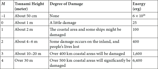
It is difficult to measure the size of a tsunami; Japanese scholars have contributed some models to calculate the sizes. As early as 1949, F. Imamura started to search for a way to calculate tsunami sizes. H. Kanamori (1972) provided the mechanism of measuring tsunamis by comparing and contrasting two tsunami earthquakes: the Sanriku in 1896 and the Aleutian Islands in 1946. In 1980, Abe and Kanamori studied the shallow earthquakes to measure wave scale based on data from 1951 to 1977 (Abe and Kanamori 1980). The first well-known model to measure tsunamis was the Imamura-Iida model, created by F. Imamura and K. Iida, which is characterized by 0–4 tsunami levels, with “m” indicating the magnitude of the tsunami. The Imamura-Iida model concludes that the tsunami energy will increase by four times as “m” goes up one level (see table 1.1).
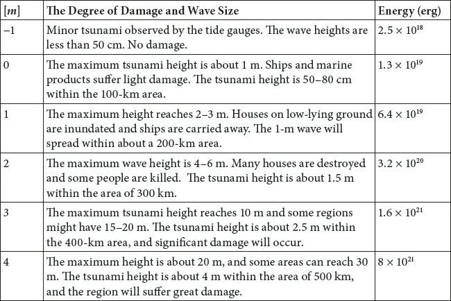
The second model of the measure of a tsunami’s power is called the Hatori model, which was proposed by T. Hatori from Tokyo Imperial University. He has suggested a comparable scale with six levels (from [−1] to [4]) to measure tsunami sizes, utilizing “m” to designate the magnitude of the tsunami. For instance, the Keicho Sanriku tsunami in 1611 and the Hoei tsunami in 1707 were m = [4] class tsunamis, while the Ansei Tokai tsunami and the Ansei Nankai tsunami in 1854, as well as the Showa Sanriku tsunami in 1933, were m = [3] class tsunamis. One of the most famous earthquakes in the world, the Taisho Kanto earthquake in 1923, caused a tsunami that was merely an m = [2]. The Niigata tsunami in 1964 was an m = [2] as well. The Tokachi Coast tsunami in 1968 was an m = [1] class tsunami, while the Tokachi Coast tsunami in 1961 was an m = [0] (Hatori 1977a; Hatori 2000).
Table 1.1 The Imamura-Iida Tsunami Model
Note: The calculation of m which is referred to as tsunami magnitude, is based on m = log2Hmax (Hmax indicates the maximum height of the tsunami)
Source: Shuto et al., eds. (2007), 42.
In 2000, Hatori reexamined his tsunami model grounded on tsunami data in the Sanriku Coastal Region between 1611 and 1861 (Hatori 2000). Based on thirty-one tsunamis occurring in Japan during the period from 1896 to 1983, Hatori concluded that the energy carried by tsunamis increases five-fold at each level (Hatori 1986; Hatori 1978b). (See table 1.2.) The Hatori tsunami model has been widely used by many scientists and Japanese governmental agencies (Usami 2003).
Table 1.2. The Hatori Tsunami Model
Note: The calculation of m, which is referred to as tsunami magnitude, is based on m = 2.7log H + 2.7 log Δ – 4.3 (H indicates the maximum of tsunami height as a meter; Δ refers to the range [20–2,000 km] between the epicenter to the monitor point).
Source: T. Hatori (1986b). Also see T. Hatori (2000), 44–45.
The third model to measure tsunami waves is by the Japan Meteorological Agency (JMA). Their model is the basis of the tsunami warning/advisory system, and lacks the details of the tsunami sizes and the degree of expected damages (see table 1.3). Based on the JMA tsunami warning system, Watanabe (2003) suggests that negative tsunamis have occurred in the Miyagi Coast, Tokachi, and Izu Peninsula Coast by analyzing the 108 years of data from 1894 to 2002.
Like with hurricane categories in the United States, one Japanese scholar has tried to put tsunamis in categories that measure their forces (Shuto 2007). Unfortunately, the category system has not been used in the world or even Japan.
Tsunami, according to Kojien [The Great Japanese Dictionary], is defined as a wave that arises from the bottom of the ocean due to an upheaval and collapse or a volcano’s eruption (Shinmura 1998). The deeper in the ocean the tsunami occurs, the faster the tsunami will travel to coastal areas. The fastest tsunami can match the speed of an eight-hundred-kilometer-per-hour airplane (JMA 2011). During the greatest Japanese disasters, such as undersea earthquakes or volcanos that erupt in the ocean, there is often less damage to people’s properties; however, the tsunami that is caused by the earthquake or volcano usually kills more people and creates gigantic destruction. As scientists have warned, a three-meter tsunami can easily reach the height of traffic signs and destroy houses and factories, spreading a few hundred kilometers. In fact, human beings are not able to stand up at all if the tsunami reaches fifty centimeters high, about as high as most people’s knees (Oki and Koketsu 2011). If the tsunami reaches above three meters, about 10 percent to 20 percent of affected homes will be destroyed, but the damage rate will go up once the tsunami gets to four meters, washing out 50 percent of the houses (Hatori 1984b). Consequently, the 2011 Sanriku Coast tsu...