![]()
1. Before the Bubble
Only a few years ago you would have sworn the commuter next to you was crazy. He talks into the air, as if to an imaginary friend, while playing with a tiny box he holds in front of his face. His whole world is a bubble two feet around his head. If, by a miracle, you get his attention and ask him questions, he can only answer by manipulating his tiny box. He checks the box and can tell you tomorrow’s weather, which way is north, and the name of that bright star in the sky. You hide the box, and he becomes helpless. You ask him, “Why is it warm in the summer and cold in the winter?” By way of explanation, the commuter gestures with his hands in front of his face. His left hand becomes the Sun and his right index finger becomes the Earth as it orbits his fist. He mumbles something about the Earth’s being closer to the Sun in the summer and farther away in the winter. His voice has a rising inflection that begs your affirmation.
Now let’s suppose it is three thousand years ago and you have transported yourself into a fisherman’s boat, far from land. He sings to himself as he hauls in a net from the sea. You ask him questions about the weather and the sky; he thinks you are crazy but humors you anyway. He confidently rattles off tomorrow’s weather, points north, and tells you a story about the bright star in the sky. He has no magic box to hide. You ask him, “Why is it warm in the summer and cold in the winter?” His outstretched arm traces an arc toward the sky, and he says that the Sun takes a high path in the summer, and the days are long; but in the winter the Sun has a low path, and the days are short. His voice has no hint of uncertainty.
Whom would you consider the more primitive of the two: the commuter or the fisherman? As information technology has grown, our ability to perceive and think independently without help from devices may be compromised to the point where we, not our forebears, are the primitive ones. Long before the advent of the Global Positioning System (GPS), our distant ancestors traveled vast distances using what seem to us to be primitive technologies. In many cases explanations for the effectiveness of their systems only arose in the twentieth century; some remain a mystery. Systems of navigation developed by different cultures may not have been based on an understanding of science as we conceive it today, but they made sense, and they worked. While the device-addicted commuter may seem oblivious to and clueless about his surroundings, his ancestors proved that humans can absorb exceedingly subtle environmental clues to find their way.
To many of us, the word “navigator” conjures up the image of a naval officer on board a ship with a sextant pointed at the stars. But the term means far more than that. Each of us is a navigator; we are constantly finding our way in our environment. The skill set needed to journey long distances is influenced by a number of factors—mode of transport, destination, the environment in which the journey takes place—and depending on the elements involved, different skills come into play, creating what I call “cultures of navigation” that are specific to the environment and mode of travel. In this book I examine these cultures and the various ways humans are able to navigate, using simple instruments and environmental clues.
Dissecting older cultures of navigation is a challenging task. Navigators, as a group, were not inclined to document their travels. Much of what we can gather about their techniques is based on fragmentary information: archaeological remains and traces of earlier languages, sagas, and chants passed down for generations. Ancient historians have left us narratives, but we ought to view them with appropriate skepticism. Cultures that developed in relative isolation before and even during Western European contact retain many of their traditional navigational schemes. By piecing together our knowledge of cultures of navigation, we can begin to appreciate a kinship we all share in the very human art of way-finding.
My work with students has convinced me that people can develop their own intuitive navigational skills. Many of these techniques, often presented in mysterious nuggets in diverse “how-to” books used by outdoor enthusiasts and survivalists, are frequently workable schemes, but whose subtleties can only be acquired through experience. What is needed is the time outdoors to allow a learning process. I will try to convey these techniques to you in this book, but there is no substitute for leaving the bubble and experiencing the Sun, the stars, the wind, and the waves. As you become more familiar with techniques of navigation that employ natural phenomena, you will gain an appreciation of the sophisticated skills developed by many cultures in the past.
Three of the most remarkable early cultures of navigation are those of the Norse, of medieval Arab traders, and of Pacific Islanders. Although I will not focus exclusively on these three cultures in this book, I will return to them many times to illustrate the schemes and adaptations I will discuss here.
The Norse began to colonize Iceland in the ninth century AD. According to Norse sagas, when they arrived they found Irish monks already living in established settlements. The monks may have found their way there by following the paths of migrating birds in crude boats called currachs.1 The Landnámabók (Book of Settlement) describes the first Norse contact with Iceland as occurring because of the accidental drift off course by a sailor named Naddoddr who was sailing between Norway and the Faroe Islands. Subsequent deliberate voyages established permanent Norse settlements in Iceland.
The violent storms and large waves that sweep the North Atlantic make navigating in the waters off Iceland and Greenland a challenge. Also, fog banks obscure the Sun for days at a time. Certainly, life on the open sailing vessels was miserable and exhausting. To sail deliberately to a destination in those waters, a navigator would have to be able to read the weather to gain a favorable wind and construct a vessel capable of sailing into the wind if necessary. Voyages were possible only in the summer months, when, unfortunately, few stars were visible at the high latitudes of Iceland and Greenland. Navigators had to rely mainly on the Sun and other natural signs to gain their bearings.
The first sighting of Greenland, somewhat before AD 1000, also appears to have been due to an accident, when Gunnbjörn Ulfsson, sailing from Norway to Iceland, was blown off course. By legend, Erik Thorvaldsson (Erik the Red) established the first colony in Greenland soon thereafter. A number of settlements along the south coast of Greenland were established but died out around the fourteenth century.
The first documented European sighting of North America also apparently came about by accident, just like the discoveries of Iceland and Greenland. The Saga of the Greenlanders describes a voyage from Iceland to Greenland by a Bjarni Herjolfsson, who was lost, along with his crew, for several days in a fog bank. When the Sun enabled him to regain his bearings, he encountered a land covered in forests that did not resemble Greenland. So he returned. Word reached Leif Eriksson, who, according to the Saga, embarked on a voyage to find the land that Bjarni encountered. The Saga of the Greenlanders describes a rich land, teaming with forests and salmon, along with hostile natives who attacked the Norse. Many of the descriptions of parts of the coast that Leif sailed along correspond well to parts of the North American coast.
A significant archaeological finding provides evidence of Norse attempts to colonize North America. In 1960 Helge Ingstad discovered the remains of a Norse village on the northernmost edge of Newfoundland, called L’Anse aux Meadows. Whether this was a primary Norse settlement or a staging area for forays farther to the south is uncertain, but the find does establish a Norse presence in North America in the eleventh century. This may have functioned as a wintering and repair stop for more explorations to the north and south.2
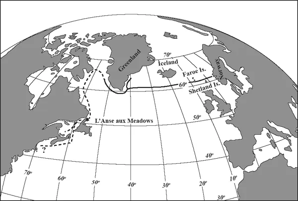
Figure 1 Routes of Norse from Norway to settlements in Greenland (solid) and Leif Eriksson’s possible route to North America (dashed) around the eleventh century AD.
Figure 1 shows the regions of the North Atlantic traversed by the Norse. These include a direct route from Norway to settlements in Greenland (solid line) along with a plausible route followed by Leif Eriksson (dashed line). The location of L’Anse aux Meadows is indicated on the northeast tip of Newfoundland. Judging from the Norse sagas, their stay in North America was short-lived. Many writers have speculated about the southerly extent of their voyaging, with Cape Breton, the coast of New England, and even Long Island suggested as destinations.
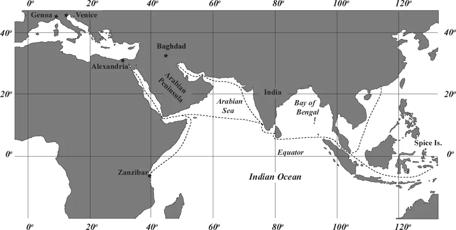
During the Middle Ages and into the Renaissance, Arab voyagers sailed the Indian Ocean conducting a lucrative trade involving silk, slaves, and spices. The alternative to the Indian Ocean was an arduous overland route, where goods changed hands many times, with a markup at each of the many cities along the Silk Road. Figure 2 shows the geography and approximate routes of Arab traders in the Indian Ocean from China, the Spice Islands, and Zanzibar to such trading cities as Alexandria and Baghdad.
Earlier forays by the ancient Persians, Greeks, and Romans often hugged the coast in vessels powered by galley slaves using oars and supplemented with crude sails. Voyages such as these were costly and time consuming. With the development of sail configurations making it possible to sail into the wind, and by using stars to steer at night, traders sailing out of sight of land for days at a time with small crews could substantially reduce the overhead needed to bring goods to Europe. In many cases they used the height of stars above the horizon to sail along a constant latitude toward a destination.
Traders crossing the Arabian Sea confronted seasonal wind patterns that blow from southwest to northeast during the monsoon, from June through September, and reverse direction the rest of the year. Voyages to and from India could exploit these wind patterns.
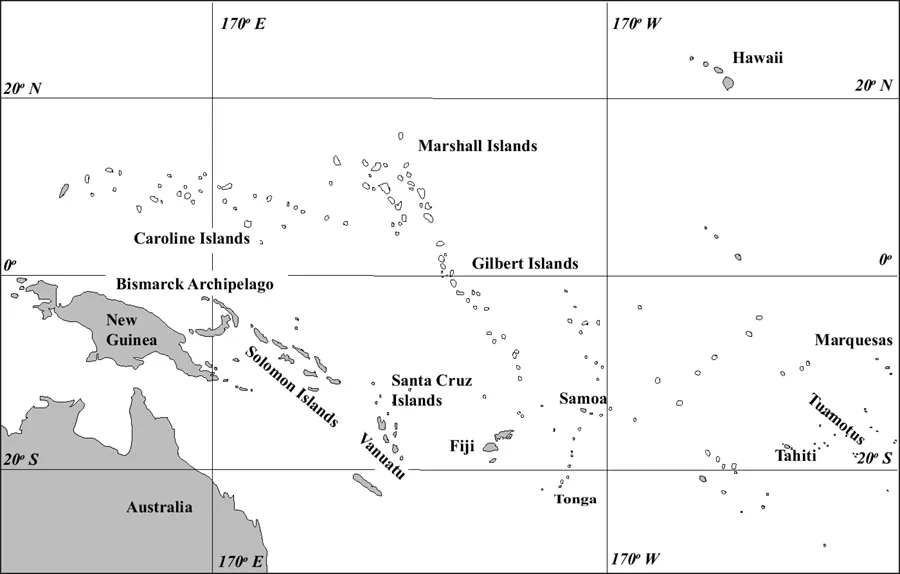
Figure 3 shows the central Pacific Ocean, a lonely expanse scattered with islands and atolls. Archaeological evidence suggests that a people called the Lapita who originated in the Bismarck Archipelago, northeast of New Guinea, began the colonization of islands to the east approximately thirty-six hundred years ago. Some of the voyages involved bold excursions of up to three hundred miles across gaps between major island groups.
The voyages of the Lapita are even more remarkable when we consider the pattern of currents and winds in the central Pacific. To travel eastward, these voyagers would have had to sail against both the prevailing wind and the current, meaning they built sailing vessels with this capability and could take advantage of seasonal shifts in weather. The pattern of colonization of the Pacific Islands from west to east against wind and current seemed counterintuitive at first and prompted scholars such as Thor Heyerdahl, author of Kon-Tiki, to speculate that the Pacific Islands were largely inhabited through accidental drifts originating in South America and proceeding westward, as opposed to deliberate eastward voyages.
Figure 2 Approximate routes of Arab trade in the Indian Ocean during the Middle Ages
On the other hand, anthropologists and archaeologists such as Geoffrey Irwin point out that an initial voyage into the wind is far safer than an initial voyage downwind.3 By sailing into the wind on an outward voyage, a safe homeward passage is assured, while an outward voyage downwind is fraught with the uncertainties of whether a return is possible.
Irwin and others base their argument on archaeological findings that show an initial eastward expansion in the direction of the Marquesas Islands, followed by longer voyages to Hawai‘i and New Zealand. The ancestors of today’s Pacific Islanders left no record of their navigational techniques, but many navigational practices in use from the time of first European contact are documented, and I will describe these in the chapters that follow.
As I said earlier, Norse, Arab, and Pacific Island navigational strategies are by no means the only ones I will describe. In fact, one could argue that mastery of navigation and sailing technologies was a major reason Western Europeans established global hegemony from the fifteenth century onward. I will describe these navigational achievements as well.
All navigational cultures have to deal with similar challenges: spatial orientation, the ability to estimate distances and find position from environmental clues. These are common to navigation on land and at sea. For mariners, in addition there is the need to predict the effects of weather, tides, and ocean currents. These challenges are the topics I cover in this book. I use the experiences of navigational cultures to illustrate the ways these challenges have been met. By focusing on the underlying science and the struggle to understand the forces of nature that confront a navigator, this book offers a tribute to the human desire to understand the world we inhabit.
There is no one “proper” way to navigate. Many individuals and cultures emphasized different skills. Often these skills were tuned to the local environment and handed down from generation to generation. A good navigator will call on multiple sources of information to complete a successful journey. No one sign or skill can be 100 percent reliable, but an array of skills, when taken together, creates a coherent picture that reinforces success.
Figure 3 Islands of the central Pacific.
You can approach this book in one of two ways: On the one hand, you can read it for an understanding of the challenges faced by voyagers trying to find their way across long distances and the ways they solved complex problems using their own cunning and available tools. On the other hand, you can use this book as an opportunity to test your own observational skills, increase your appreciation of your environment, and perhaps develop a lifetime practice. If you are interested in the latter, be forewarned: it takes practice and patience. I have found that students can become adept at reading star patterns, follo...