![]()
1
Site, surroundings and discovery
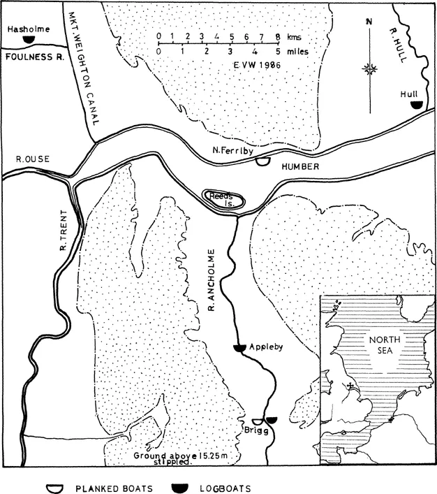
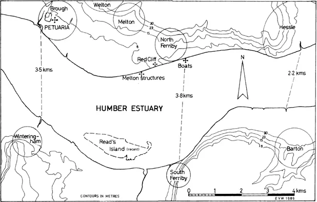
North Ferriby lies, as does its counterpart South Ferriby, tucked under the western side of the chalk escarpment of the Yorkshire and Lincolnshire Wolds where this is cut by the tidal estuary of the Humber (Figure 1.1). On the north bank the area is partially covered by a mantle of glacial till and at Ferriby itself there is today a low tongue of glacial deposits running south-west towards the shore of the estuary leaving a shallow re-entrant to the east before the chalk reaches the river-bank at Hessle and another deeper to the west between Ferriby and Brough-on-Humber (Figure 1.2). Where this tongue of glacial deposits reaches the estuary it forms a cliff some 10 m high, aptly named Red Cliff (Figure 1.3). Once tides in the estuary approached their modern levels, each of the two re-entrants became a catchment for deposition of the accumulated silts of the flood-plain of the Humber, and the ridge between provided an additional route of access from the water’s edge to the high ground inland: to the east the chalk of the Wolds, then the glacial tongue and to the west what is left of the oolitic Jurassic escarpment at Brough which is a minor feature compared with its counterpart, the Lincoln Edge to the south. Across the estuary opposite North Ferriby, the Lincolnshire Wolds fall steeply towards the shore with a thinner covering of glacial till than that on the north bank (Figure 1.4). The low ground between the Wolds and the Edge forms the valley of the River Anch-olme which drains north into the Humber at South Ferriby Sluice. Upstream of the Jurassic escarpment the flood-plain broadens out as the Vale of York to the north and west and the river Trent catchment to the south and there is no high ground to provide convenient crossings for a number of miles inland. In historic times the stretches of land between Hessle and Brough on the north bank and Barton and Winteringham on the south have for centuries been significant for north-south communication. The main link in Roman times was that between Winteringham, the road terminal north from Lincoln, and Brough which in turn gave access north to Malton and north-west to York by way of the Escrick moraine which provides some elevation above the vale. In medieval times regular crossing places were numerous as witness the extensive use of ferries on Lincolnshire rivers reviewed by Maurice Barley:
Bridges were few and so inadequate that ferries were at least equally important, nor do the former necessarily indicate the main routes into and out of the county. Domes-day gives ferries over the Humber at Grimsby (two – presumably over to one or other of the lost villages within the arm of Spurn Point), Barton-on-Humber, South Ferriby (two) and Winteringham. It is clear that by this time the main road north from Lincoln crossed the Ancholme at Brigg and the Humber at either Barton or South Ferriby.… These make it highly probable that the pre-Roman trackway along the western edge of the Wolds was the most frequented. Certainly from the 13 th Century the main crossing was between Barton and Hessle. (Barley 1936)
Figure 1.1 Location of the North Ferriby and other boat-finds in the area.
It can fairly be assumed that the area was equally important in pre-Roman times for passage north-south where the estuary is narrow and it is possible to avoid the carr-lands inland to the west. This is not to say that the low-lying areas were not inhabited or accessible. Finds of prehistoric logboats in the Ancholme valley, the Trent catchment and, most recently, the Foulness river marshes all attest to utilization of the waterways as well as the land routes.
Figure 1.2 Map of the middle Humber showing areas of high ground bordering the estuary. Modern villages circled.
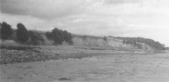
Figure 1.3 The 10-metre-high Red Cliff with section of glacial deposits. Traces of the Early Iron Age settlement were located in the 1 metre of soil at the top of the cliff edge.
Figure 1.4 View from the boat site across to the Lincolnshire shore. South Ferriby to right of centre where the woodland slopes down towards the water.
Before the landscape had been modified by deforestation, land use and settlement to something recognizably akin to its modern pattern, it is possible to visualize the area as being densely wooded on the heavier soils of the glacial deposits and more thinly so on the chalk and limestone ridges. While relative sea levels were markedly lower than today’s, the penetration of tidal, saline waters inland was less extensive than now; but as they rose the flood-plain of the Humber catchment became covered first by fen-woodland, the decaying vegetation of which formed the peat deposits which cover all the valley bottoms both west and east of the high ground. The further rising of sea levels resulted in the drowning of the fen-woodland environment and its replacement by open salt marsh from the accretion of sediments from which were formed the deposits of grey estuarine silty-clay readily recognizable where it occurs from its colour and consistency. Its faunal content gives evi-dence for the extent of tidal penetration, bringing salt water well inland up the river systems. Conditions such as these prevailed along the edges of the Humber estuary proper and well up the valleys of the rivers draining into it and they are exemplified by the deposits in the re-entrants to east and west of the tongue of glacial deposits at North Ferriby, Melton and Welton.
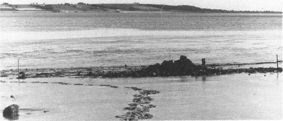
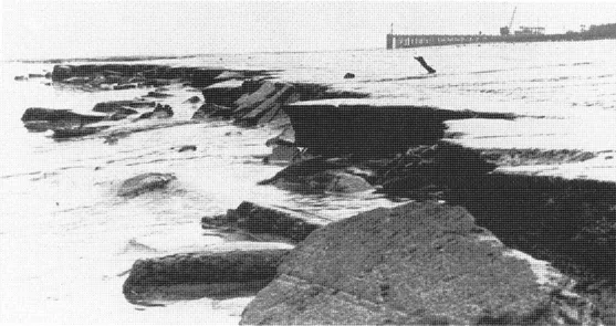
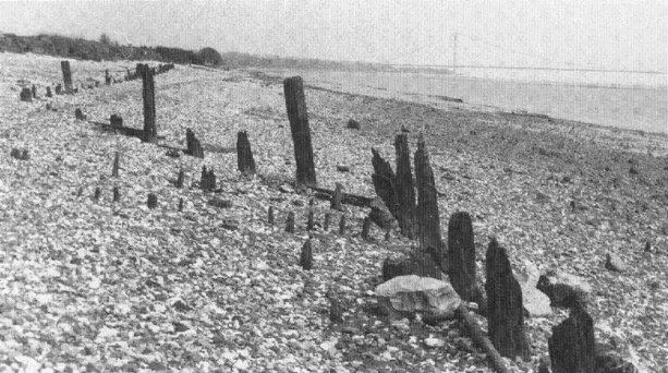
The peat and silts to the west which outcrop on the shore from Melton westwards (Figure 1.5) have been known for nearly a century and were observed and recorded by J. W. Stather (Stather 1896). Thereafter the vagaries of the silting processes in the Humber caused their submergence under inshore mudbanks for nearly fifty years; but in 1930 there was a comparatively sudden shift of the main deep-water channel used by sea-going shipping from the south to the north side of the estuary, and the whole of the recent silt was scoured away to reveal not only the Melton deposits once again, but also similar deposits in the eastern re-entrant at North Ferriby (Figure 1.6). Stather was still alive and active in the Hull Geological Society at the time (Figure 1.7) to witness this second emergence to view of these interesting post-glacial deposits and they were reported in print by W. S. Bisat, one of the leading local experts on East Yorkshire glaciology at the time (Bisat 1932).
Figure 1.5 Post-glacial deposits at Melton, first recorded by Stather in 1896.
Figure 1.6 The post-glacial deposits at North Ferriby first reported by Bisat in 1931.
My brother and I, then in our early teens, were already developing our interest in the geology, and more particularly palaeontology, of the region, encouraged often by Thomas Sheppard, the Director of the Hull Museums and knowledgeable in most fields of antiquarian and geological lore. It was he who first introduced us to the Ferriby deposits, and living as we did only a mile away they soon became a subject for regular study, initially for their faunal content of insects, molluscs, and animal bones...