![]()
Sites and regions
4. A BRIDGE BETWEEN WORLDS: SOUTH-WESTERN IRAN DURING THE FOURTH MILLENNIUM BC
Henry T. Wright
Introduction
During the last century, advances in archaeological methods have given researchers a completely different view of pre- and proto-historic cultural developments. Better stratigraphic and architectural excavation techniques, more sophisticated regional survey strategies, better approaches to contextual studies, and increasingly precise methods of absolute dating have swept away the vision of slow, steady increases in the complexity of early civilisations. Archaeologists now realise that, like the historic societies long known from the textual record, there was a mosaic of different kinds of pre- and proto-historic formations emerging and disappearing with startling rapidity. This contribution looks at one part of the great cultural mosaic of southwest Asia – south-western Iran, a bridge between the Mesopotamian alluvium and the mountain ranges and inner basins of Iran – from the end of the fifth to the middle of the fourth millennium BC. This period encompasses key steps in the development of specialised hierarchical control – the first emergence of what have been traditionally termed ”states” – and the study of the south-western Iranian region helps us better to understand the processes of earliest state formation in a broader trans-regional perspective.
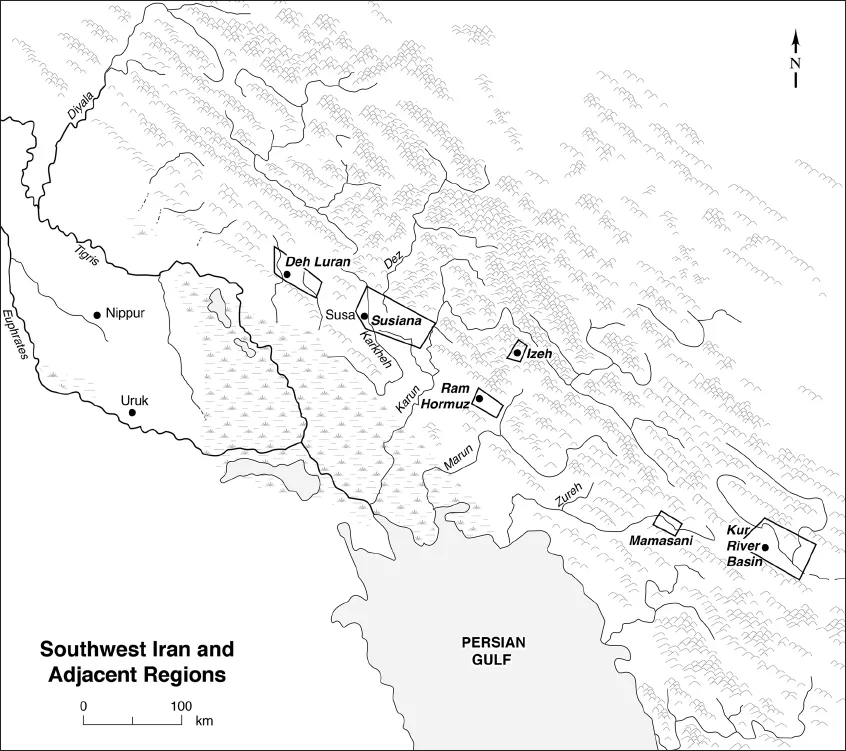
South-western Iran is relatively rich in natural resources. The front ranges and foothills of the central Zagros Mountains to the north and east have resources of stones, woods, and summer pasturage. The alluvial fans have permanent streams providing rich soil and water for permanent agriculture and pasture. The often saline and poorly watered alluvial steppes to the south-west provide winter pasture (Fig. 4.1). This alluvial desert and the marshes of the major rivers buffer south-western Iran from alluvial Mesopotamia in what is today southern Iraq, while the high Zagros buffer it from the interior plateau of Iran. There were numerous passable routes across these difficult borderlands, however, and nomads, traders, armies, and refugees were long able to move from region to region.
The cultural centre of south-western Iran throughout most of the time from the later fifth millennium BC to the end of the first millennium AD was a town called Shushun in earliest texts (Vallat 1980), Susa in classical times, and Shush today. This town gave its name to the region of Shushen, Susiana in classical times, and today the central portion of Khuzestan. In the following discussion, for four successive periods, I will first focus on the regional economy and settlement around Susa, then discuss related centres to the west and east in south-western Iran and beyond.
South-western Iran at the end of the fifth millennium BC
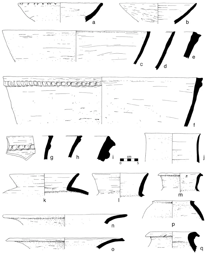
From approximately 4300 to 4150 BC, Susa was the centre of the rich Suse Phase polity, which had an organised network of smaller centres and villages whose elites participated in an elaborate display of iconography (Amiet 1972; Hole 1983; Wright 1994). By the end of the fifth millennium BC, however, this region was facing the consequences of the decline of this polity in a time of less rainfall and probably also a time of conflict with polities in alluvial Mesopotamia to the south-west (Neely and Wright 1994: 172; Wright 1994: 79). Although the ceramics is use after 4150 BC (Fig. 4.2) were technically some of the best made in the region, and were being made using fifth-millennium potting techniques and continuing the use of earlier vessel shapes, for the most part they ceased to manifest the elaborate Suse Phase symbolism. Diagnostic among these are flat-lipped basins with thumb-impressed strips below the rim (Fig. 4.2/f–i), large jars with very everted rims (Fig. 4.2/n–o), and fine jars or beakers (Fig. 4.2/j).1 These characteristic plain ceramics were recognised by Robert Dyson (1966: 315–36) in his 1954 sounding at Susa, and by Joseph Caldwell (1968: figs 7–10) in his analysis of the 1948–49 excavations at Tal-e Ghazir. None of these samples, however, are large or have very good context, and only scraps of architecture, craft debris, food remains, or other artefacts were reported. We are indebted to Gregory Johnson’s study of what he termed the Terminal Suse A Phase, as well as of the subsequent Uruk phases for key regional evidence (Johnson 1973). I suggest a date for the Terminal Suse Phase of 4150–4000 BC, concordant with Post Ubaid and Early Uruk dates from Upper Mesopotamia (Wright and Rupley 2001: 97–100).
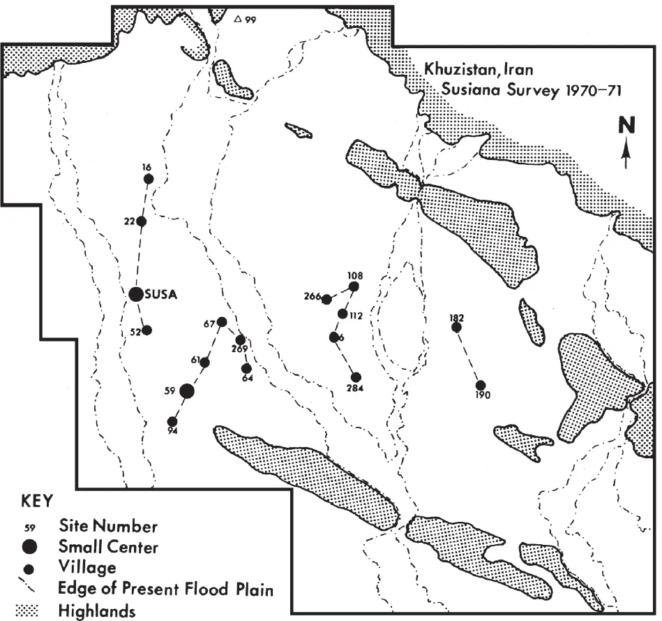
During this time, Susa was still the only definite small centre on the northern Susiana Plain. Current evidence suggests that the entire Acropole mound was occupied, with settlement covering at least 10 ha. On 16 other sites, the sherd distribution is limited, suggesting occupation at each covered 1 ha or less (Fig. 4.3) The maximum total occupied area was thus about 30 ha (Johnson 1973: 87, fig. 15 and Robert M. Schacht (1980: 791) estimated a population of 5600 people, about one third of estimates during the preceding Suse Phase. Johnson (1973: 87–90) noted that these settlements were distributed in a least three linear groups, suggesting orientation along natural or artificial watercourses, as one would expect in times of diminished rainfall.
The Terminal Suse Phase assemblage does not occur west of the Susiana Plain. There is only one possible late fifth-millennium BC site on the Deh Luran Plain, 110 km west-north-west of Susa, the village site of Sargarab (DL-169 in Neely and Wright 1994: 130–38). This settlement of small houses, courtyards, and terraces covers about 0.7 ha and has nearby check dams for rain-fed fields as well as small canals perhaps to water orchards. It has a ceramic assemblage whose closest relations are with the ceramics of northern Zagros and upper Mesopotamia with their vegetal and crushed calcite tempers (Figs. 4.4–4.5). Among the distinctive forms are tapered rim bowls (Figs. 4.4/b, 4.5/c), large bowls or basins, often with beaded rims and thumb-impressed strips (Figs. 4.4/f–j, 4.5), necked jars with round or ledge rims (Fig. 4.5/d–h, i–j), fine jars or beakers (Fig. 4.5/b) and flat-bottomed trays, perhaps bread moulds (Fig. 4.5/l). Some vessels on this ware have red slips, and some have painted horizontal bands. Another ceramic ware of northern affinity has coarse angular calcite inclusions; this is used exclusively to make large globular hole-mouth jars with thickened rims (Fig. 4.5g). There is, in contrast, one unmistakable sand-tempered Terminal Suse Phase basin rim (Fig. 4.4/e) and two sand-tempered ledge rim jars (Fig. 4.5/k) of Early Uruk affinity, indicating contact between these different ceramic traditions.
In contrast, sites on the lower alluvium of the Tigris and Euphrates to the south-west exhibit a different ceramic style, a Terminal ‘Ubaid assemblage, although it is placed in the Early Uruk period by some (Adams and Nissen 1972: 99–100). The technology and forms of these vessels are similar to those of Late ‘Ubaid ceramics, but lack painted decoration except on a few small jar necks and shoulders. It seems that the factors which led Terminal Suse Phase potters to cease painting their pottery might have also motivated ‘Ubaid potters as well. In contrast to south-western Iran, however, Adams (1981: 60–75, fig. 11) has demonstrated that there were more and much larger sites in Mesopotamia, particularly in the area east of Nippur. The largest of these, Tell Al-Hayyad, covered almost 50 ha (Adams 1981: 280, figs 11,13,14). It would not be surprising if this dense settlement network had impacts on the much smaller centres and settlement systems in south-western Iran. Among the possible motivations are conflict over interstitial areas of pasturage and marshland between lower Mesopotamia and Susiana, or competition over access to highland raw materials. However, these were relatively small populations, marsh and pasture areas were vast, and the demand for highland resources would have been small.
East of the Susiana Plain during this period, scattered occupation is attested. On the Ram Hormuz Plain 110 km from Susa, occupation is known only from the high central mound of Tal-e Ghazir (Caldwell 1968: 350, figs 7–10). In the mountains to the north and north-east, survey has recorded a large campsite with Terminal Suse Phase sherds on the plain of Qaleh Tol, 50 km north-east of Ghazir (Wright 1987: 144), and two small village sites on the plain of Izeh (Shahideh 1979: 54). These sites are in parts of the plains that are without summer water supplies, and may be the sites of transhumant pastoralists. Farther east, in the large and high Kur River Basin of southern Iran (Sumner 1988, also 1994), small early Lapui Phase centres and villages flourished, but there are no indications of stylistic similarities to Susiana at this time. In the smaller plains of Mamasani, which lies 90 km west-north-west of the Kur River Basin, excavation at Tol-e Spid (Petrie et al. 2009: 93–95, 101–05, 124,figs 4.50–4.59) and Nurabad (Weeks et al. 2009: 36, 49–53, 3.99–3.102 ), has documented few similarities to Terminal Suse Phase assemblages. Definitively early Lapui layers, however, have not yet been reported (see Petrie et al., this volume). Similarly, there is little evidence from surface survey of material with relations to the Terminal Suse Phase (McCall 20...