![]()
Part I
Basic Concepts of GIS
![]()
Chapter 1
Some Concepts That Underpin GIS
OVERVIEW
IN WHICH you begin to understand the rather large and complex body of ideas and techniques that allow people to use computers to comprehend and design the physical environment. And in which you use Esri’s ArcCatalog to explore geographic data.1
You Ask: “What Is GIS About?”
A poem “The Blind Men and the Elephant” tells the story of six sightless men who approach an elephant, one by one, to satisfy their curiosity.
It was six men of Indostan
To learning much inclined
Who went to see the Elephant
(Though all of them were blind)
That each by observation
Might satisfy his mind.
The First approached the Elephant,
And happening to fall
Against his broad and study side,
At once began to bawl,
“God bless em! But the elephant
Is very like a WALL!”
The Second, feeling of the tusk
Cried: “Ho! what have we here
So very round and smooth and sharp?
This wonder of an Elephant
Is very like a SPEAR!”
The Third approached the animal,
And, happening to take
The squirming trunk within his hands,
Thus boldly up and spake:
“I see,” quoth he, “the Elephant,
Is very like a SNAKE!”
The Fourth reached out an eager hand,
And felt about the knee
“What most this wondrous beast is like
Is mighty plain,” quoth he:
“’Tis clear enough the Elephant
Is very like a TREE!”
The Fifth, who chanced to touch the ear,
Said: “E’en the blindest man
Can tell what this resembles most;
Deny the fact who can,
This marvel of an Elephant
Is very like a FAN!”
The Sixth no sooner had begun
About the beast to grope,
Than seizing on the swinging tail
That fell within his scope,
“I see,” quoth he, “the Elephant
Is very like a ROPE!”
And so these men of Indostan
Disputed loud and long,
Each in his own opinion
Exceeding stiff and strong
Though each was partly in the right
And all were in the wrong!
[. . .]2
Excerpted from “The Blind Men and the Elephant”
(based on a famous Indian legend)
John Godfrey Saxe
American Poet (1816–1887)
And So You Ask Again: “What Is GIS About?”
Poet Saxe’s lines could apply to geographic information systems (GIS) in that relating to the subject may well depend on your point of view. Asking what GIS3 is about is sort of like asking “What is a computer about?” The capabilities of GIS are so broad and its uses so pervasive in society, geography, urban and regional planning, and the technical world in general that a short, meaningful description is impossible. But for starters, here is a generic definition of GIS that you might find in a dictionary:
To better understand one facet of GIS, consider how you might use the technology for a particular application. Solve the following site selection problem:
Exercise 1-1 (Project)
Finding a Geographic Site by Manual Means
Wildcat Boat Company is planning to construct a small office building and testing facility to evaluate new designs. They’ve narrowed the proposed site to a farming area near a large lake and several small towns. The company now needs to select a specific site that meets the following requirements:
- The site should not have trees (to reduce costs of clearing land and prevent the unnecessary destruction of trees). A regional agricultural preservation plan prohibits conversion of farmland. The other categories (urban, barren, and wetlands) are also out. So, the land cover must be “brush land.”
- The building must reside on soils suitable for construction.
- A local ordinance designed to prevent rampant development allows new construction only within 300 meters of existing sewer lines.
- Water-quality legislation requires that no construction occur within 20 meters of streams.
- The site must be at least 4000 square meters to provide space for building and grounds.
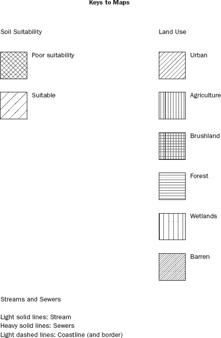
Figure 1-1 is a key to the following maps. It shows the symbols for land cover, soil suitability, streams, and sewers.4
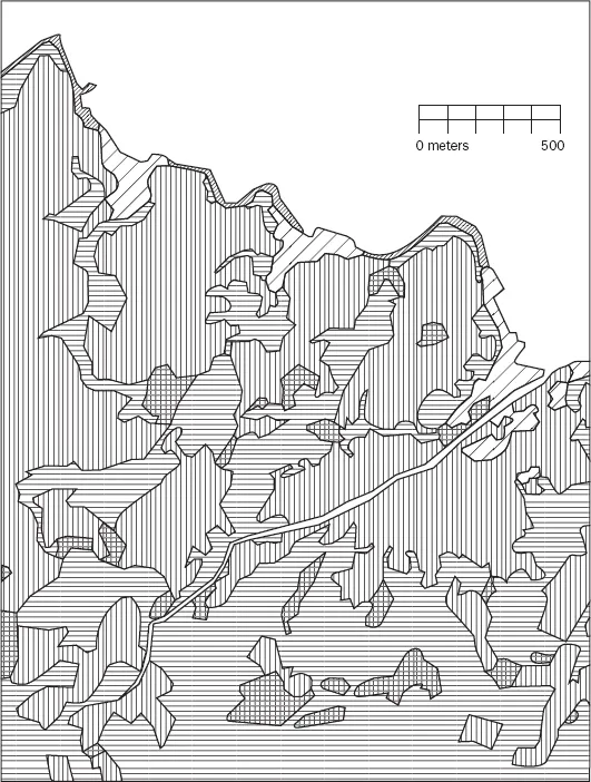
Figure 1-2 is a map showing landcover in the area from which the site will be chosen. Different crosshatch symbols indicate different types of land cover; the white area in the northern part of the map is water. The land cover codes (LC Codes) and categories (LC Type) are as follows:
| LC CODE | LC TYPE |
| 100 | Urban |
| 200 | Agriculture |
| 300 | Brush land |
| 400 | Forest |
| 500 | Water |
| 600 | Wetlands |
| 700 | Barren |
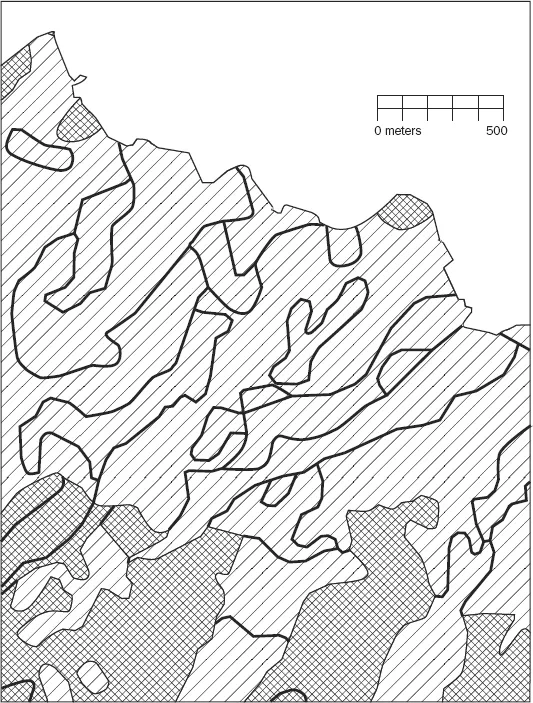
Figure 1-3 is a soil suitability map. Lines separate soils of different types. The different soils are categorized as suitable or unsuitable for building. Therefore, you will see the same symbol on both sides of a dividing line, indicating that, while such soil types may be different, their suitability is the same.
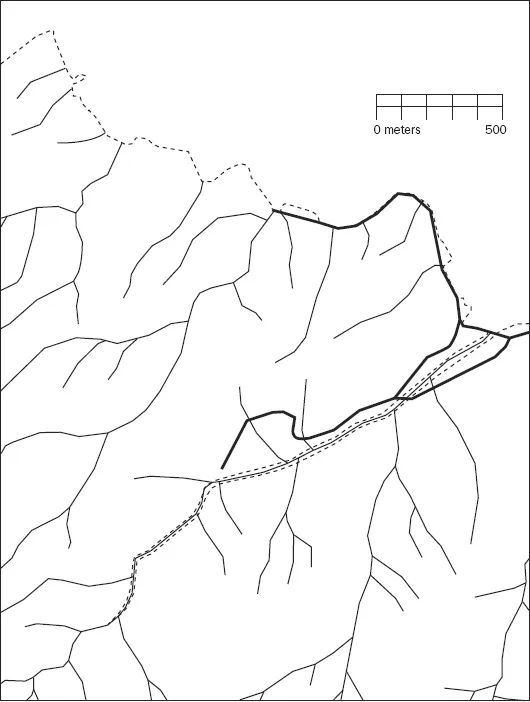
Figure 1-4 is a map that shows the streams (narrow lines) and sewers (broader lines).
You may use scissors, xerography, a computer-based drawing program, a light table, and any other tools to solve the problem.
You are asked to present a map that shows all, repeat ALL, the areas where the company could build, while meeting the requirements stated previously. Make your map the same scale and size as those maps provided on the DVD. Outline in red all the areas that meet the requirements. You don’t need to produce a high-quality cartographic product. The main objective here—indeed the object of this textbook—is to analyze geographic data. While making maps is important, it is not the primary focus of this book.
Write a brief description (100 to 200 words) of the procedure you used to make the map.
The problem is much easier than it might otherwise be because the maps provided cover exactly the same area, have the same underlying assumptions regarding the shape and size of Earth, are at the same scale, and use the same projection of Earth’s sphere onto the flat plane of the map. These benefits are often not available in the real world, where you frequently need a considerable amount of data preparation to solve such a problem. ArcGIS has many tools to aide in “lining up” geographic data. Despite these advantages, the process can be somewhat daunting.
More of What GIS Is About
Completing Exercise 1-1 showed how GIS can help you solve one kind of problem. There are many others. Computer-based GIS not only serves the purpose of traditional maps but also helps you perform activities that involve spatial analysis, even without maps. Understanding conditions that occur in the vicinity of Earth’s surface are important in building structures, growing crops, preserving wildlife habitat, protecting ourselves from natural disasters, navigating from one point to the next, and a myriad of other activities.
Among the many uses of GIS are:
Land use—Helps determine land uses, zoning, environmental impact analysis, locational analysis, and site analysis.
Natural environment—Identifies, delineates, and manages areas of environmental concern, analyzes land-carrying capacity, and assists in developing environmental impact statements.
Energy—Examines costs of moving energy, determines remaining available energy reserves, investigates the efficiency of different allocation schemes, reduces waste, reduces heat pollution, identifies areas of danger to humans and animals, assesses environmental impacts, sites new distribution lines and facilities, and develops resource allocation schemes.
Human resources—Plans for mass transit, recreation areas, police unit allocation, and pupil assignment; analyzes migration patterns, population growth, crime patterns, and welfare needs. It also manages public and government services.
Areas of environmental concern—Facilitates identification of unique resources, manages designated areas, and determines the relative importance of various resources.
Water—Determines floodplains, availability of clean water, irrigation sc...