Remote Sensing Imagery
  1. English
  2. ePUB (mobile friendly)
  3. Available on iOS & Android
eBook - ePub

About this book

Dedicated to remote sensing images, from their acquisition to their use in various applications, this book covers the global lifecycle of images, including sensors and acquisition systems, applications such as movement monitoring or data assimilation, and image and data processing.
It is organized in three main parts. The first part presents technological information about remote sensing (choice of satellite orbit and sensors) and elements of physics related to sensing (optics and microwave propagation). The second part presents image processing algorithms and their specificities for radar or optical, multi and hyper-spectral images. The final part is devoted to applications: change detection and analysis of time series, elevation measurement, displacement measurement and data assimilation.
Offering a comprehensive survey of the domain of remote sensing imagery with a multi-disciplinary approach, this book is suitable for graduate students and engineers, with backgrounds either in computer science and applied math (signal and image processing) or geo-physics.

About the Authors

Florence Tupin is Professor at Telecom ParisTech, France. Her research interests include remote sensing imagery, image analysis and interpretation, three-dimensional reconstruction, and synthetic aperture radar, especially for urban remote sensing applications.
Jordi Inglada works at the Centre National d'Études Spatiales (French Space Agency), Toulouse, France, in the field of remote sensing image processing at the CESBIO laboratory. He is in charge of the development of image processing algorithms for the operational exploitation of Earth observation images, mainly in the field of multi-temporal image analysis for land use and cover change.
Jean-Marie Nicolas is Professor at Telecom ParisTech in the Signal and Imaging department. His research interests include the modeling and processing of synthetic aperture radar images.

Frequently asked questions

Yes, you can cancel anytime from the Subscription tab in your account settings on the Perlego website. Your subscription will stay active until the end of your current billing period. Learn how to cancel your subscription.
No, books cannot be downloaded as external files, such as PDFs, for use outside of Perlego. However, you can download books within the Perlego app for offline reading on mobile or tablet. Learn more here.
Perlego offers two plans: Essential and Complete
  • Essential is ideal for learners and professionals who enjoy exploring a wide range of subjects. Access the Essential Library with 800,000+ trusted titles and best-sellers across business, personal growth, and the humanities. Includes unlimited reading time and Standard Read Aloud voice.
  • Complete: Perfect for advanced learners and researchers needing full, unrestricted access. Unlock 1.4M+ books across hundreds of subjects, including academic and specialized titles. The Complete Plan also includes advanced features like Premium Read Aloud and Research Assistant.
Both plans are available with monthly, semester, or annual billing cycles.
We are an online textbook subscription service, where you can get access to an entire online library for less than the price of a single book per month. With over 1 million books across 1000+ topics, we’ve got you covered! Learn more here.
Look out for the read-aloud symbol on your next book to see if you can listen to it. The read-aloud tool reads text aloud for you, highlighting the text as it is being read. You can pause it, speed it up and slow it down. Learn more here.
Yes! You can use the Perlego app on both iOS or Android devices to read anytime, anywhere — even offline. Perfect for commutes or when you’re on the go.
Please note we cannot support devices running on iOS 13 and Android 7 or earlier. Learn more about using the app.
Yes, you can access Remote Sensing Imagery by Florence Tupin, Jordi Inglada, Jean-Marie Nicolas, Florence Tupin,Jordi Inglada,Jean-Marie Nicolas in PDF and/or ePUB format, as well as other popular books in Technology & Engineering & Civil Engineering. We have over one million books available in our catalogue for you to explore.
Part 1
Systems, Sensors and Acquisitions

Chapter 1

Systems and Constraints

1.1. Satellite systems

A remote sensing satellite placed in orbit around the Earth is subject to several gravitational forces that will define its trajectory and motion. We will see that orbit formalism dates as far as Kepler (1609), and the motion of satellites is modeled using Newton’s laws. The Earth has specific properties, such as being flat at the poles; these specificities will introduce several changes to the Kepler model: quite strangely, as we will see, the consequences will turn out be extremely beneficial for remote sensing satellites, since they will allow us to have heliosynchronous sensors; this will enable them to acquire data at the same time as the solar hour, which in turn simplifies the comparisons of the respective data acquisitions.
The objective of this chapter is to briefly analyze orbital characteristics in order to draw some conclusions regarding the characteristics of imaging systems that orbit the Earth. For more details, readers can refer to the work of Capderou [CAP 03].

1.2. Kepler’s and Newton’s laws

By studying the appearance of the planets around the Sun (and, in particular, that of Mars), in 1609, Kepler proposed (in a purely phenomenological manner) the following three laws describing the motion of planets around the Sun:
– The planets’ trajectory lies in a plane and is represented by an ellipse having the Sun as its focus.
– The area swept out by the segment joining the Sun and the planet during a given period of time is constant.
– The square of the revolution period is proportional to the cube of the length of the major axis of the ellipse.
In 1687, Newton demonstrated these laws by giving us a model of the universal attraction. This model stipulates that two punctual masses m and M exercise a force F against each other, colinear to the line joining these two masses:
img_0004_0001.webp
with G = 6.672 × 10⁻¹¹ being the gravitational constant. Therefore, an interaction takes place between the two masses.
In the case of artificial satellites orbiting the Earth, it is obvious that the Earth’s mass (MT = 5.5974 × 1024 kg) is extremely large with respect to the mass of the satellite and we can easily assume that the center of the Earth may be mingled with the gravitational center of the Earth + satellite system. If we also assume that the Earth is a homogeneous sphere, we can consider it as a punctual mass by applying the Gauss theorem. The satellite with a mass m, located at a distance r from the Earth (with a mass MT), is then subjected to a so-called attractive “central force”:
img_0004_0002.webp
with μ = G MT = 3.986 × 10¹⁴ m3s –2. Therefore, we can say that we have a central potential U (r):
[1.1]
eq_0004_0001.gif
This force being the only one that can modify the motion of the satellite, we can therefore show that this motion verifies the following essential properties:
– The trajectory of the satellite lies in a plane, the “orbital plane”. The distance r verifies, using polar coordinates, the equation of an ellipse:
[1.2]
eq_0004_0002.gif
described by two parameters: the eccentricity e and the parameter p of the ellipse. The Earth is at one of the foci of this ellipse: this is the first Kepler law. For an ellipse, a trajectory point is solely determined by the angle θ. Just like for θ′ = θ + 2π we find the same position values, we can say that the trajectory is closed in the orbital plane. The period of time that a satellite needs to pass from an angle θ to an angle θ + 2π is called a period: this is the period of time required for circling the Earth. An elliptic orbit has two main points:
– for θθ0 = 0, we see that value r is at its minimum. We say that we are at the “perigee”: the distance to Earth is denoted as rP;
– for θθ0 = π, we see that the value r is at its maximum. We say that we are at the “apogee”: the distance to Earth is denoted as rA.
We can easily deduce the relations:
[1.3]
eq_0005_0001.gif
– Since the attractive force is colinear to the distance vector
rbar.gif
, and there is no other force, the angular momentum
hbar.gif
[1.4]
eq_0005_0002.gif
is conserved, so that:
img_0005_0001.webp
where C is a constant that represents the law of equal areas, i.e. the second Kepler law.
– An ellipse can be characterized by its semimajor axis a defined by:
img_0005_0002.webp
By applying the law of equal areas, we obtain the period T of the satellite:
[1.5]
eq_0005_0003.gif
which is the expression of the third Kepler law. The parameters of this period T are, therefore, only a – the semimajor axis – and μ (related to the Earth’s mass).
On an ellipse, the speed is not constant. We show that
[1.6]
eq_0006_0001.gif
except when we have a perfectly circular trajectory, for which we have:
[1.7]
eq_0006_0002.gif
The speed of a satellite varies along its trajectory around the Earth. The speed is, therefore, higher as the distance r becomes smaller. More specifically, if vP is the speed at the perigee (with rP = a(1 – e)) and vA is the speed at the apogee (with rA = a(1 + e)), we get:
img_0006_0001.webp
From this, we may then deduce the following useful relation:
[1.8]
eq_0006_0003.gif
which shows that the ratio of the speeds to the perigee and apogee depends only on the eccentricity and therefore on the shape of the ellipse.
To conclude on the general aspects of orbits, we must emphasize the fact that these ellipses only need two parameters to be described accurately. We often choose a, the semimajor axis, and e, the eccentricity.

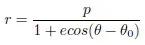
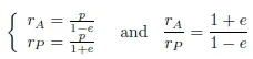
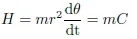
1.3. The quasi-circular orbits of remote sensing satellites

The satellite era started with the launch of the first satellite Sputnik in 1957. Some numbers of civilian remote sensing satellites have since been placed in orbit around the Earth. These orbits, whose eccentricity is very low (e < 0.001), are quasi-circular and, therefore, described either by the semimajor axis a or by their altitude h, defined by the relation:
img_0007_0001.webp
with RT = 6, 378.137 km being the radius of the Earth at the equator. We often speak of a circular orbit for this type of orbit.
Choosing an orbit for a remote sensing satellite needs to consider several things. First and foremost, since we can show that the energy of an orbit only depends on the semimajor axis a, we must note that the choice in altitude is restrictive in terms of launch: a high altitude requires a launcher that is both heavy and expensive. Therefore, it does not seem to be appropriate to choose a high altitude for an optical imaging system: the resolution being proportional to the distance, a low altitude will allow u...

Table of contents

  1. Cover Page
  2. Contents
  3. Title Page
  4. Copyright
  5. Preface
  6. Part 1: Systems, Sensors and Acquisitions
  7. Part 2: Physics and Data Processing
  8. Part 3: Applications: Measures, Extraction, Combination and Information Fusion
  9. Bibliography
  10. List of Authors
  11. Index