![]()
1
Picts and Romans
If anyone had doubts about the origins of the Picts, the Romans were not among them. A document dating from the early fourth century called “The Barbarian Nations that sprang up under the [Roman] Emperors,” claims that they created the Picts.1 Setting aside the title, the text is essentially a roll call of the peoples living outside the empire with which the Romans had contacts and its thesis is clear even before the completion of the inventory of 53 “nations” located beyond the imperial frontiers. This is a jumble of anciently known peoples together with nations which had recently appeared in the written records. As well as such fresh names as the Picts and Alemani there are older names such as the Caledonians and Persians. The tract shows Roman bigotry (a barbarian was a barbarian regardless of antiquity or achievements) together with a keen awareness that they were not living in isolation and that some knowledge of the people outside their borders might be helpful.
Fifteen hundred years later there was less certainty about the Picts. In 1971 the BBC broadcast a television program, accompanied by a book, with the title Who are the Scots? Various authors contributed chapters describing the different peoples who had settled in Scotland, beginning with the earliest inhabitants and culminating with the francophone emigrants of the High Middle Ages.2 With one exception, the chapter titles are simple, such as “Britons and Angles” or “Scots of Dalriada.” The exception is a chapter with the title “The Problem of the Picts.” The phrase was an acknowledgment of an influential book called The Problem of the Picts, edited by F.T. Wainwright and published in 1955, based on a collection of papers originally delivered at a conference in Dundee in 1952 held under the auspices of the Scottish Summer School of Archaeology. The individual essays fell into four categories that have largely defined the avenues of inquiry since then: history, archaeology, art history, and language. A dozen years later, Isabel Henderson published The Picts which drew together the separate topics into a continuous narrative. In those works, as in subsequent English-language studies, the Picts were limited to Britain and their history begun in the last centuries of the Western Roman Empire.
Before the Picts
The peoples of northern Britain were a military concern for the Romans even before the appearance of the name Pict.3 Tacitus gives an account of the peoples of northern Britain in his Agricola where he uses the generic term Britons (which in its widest application referred to everyone in the island) while mentioning specific peoples such as the Caledonians and Borestras. When Claudius Ptolemeus (the second-century geographer better known as Ptolemy of Alexandria) described Britain north of the Antonine Wall in his Geographia, he identified 16 peoples living in what is now Scotland.4 Suggestions on the locations of these groups place the Caereni, Cornavii, Lugi, and Smertae in the region of what is now Caithness and Sutherland, while the Decantae and Carnonacae were in Ross. Between the Moray Firth and the Firth of Forth were the Caledonii, the Vacomagi, the Taexali, and the Venicones in the east, with the Crenoes and Epidii in the west. The southern peoples, between the Antonine and Hadrian walls, were the Novantae and Selgovae in Galloway and Dumfriesshire, the Damnonii to their east, and the Otadini in what is now Lothian.
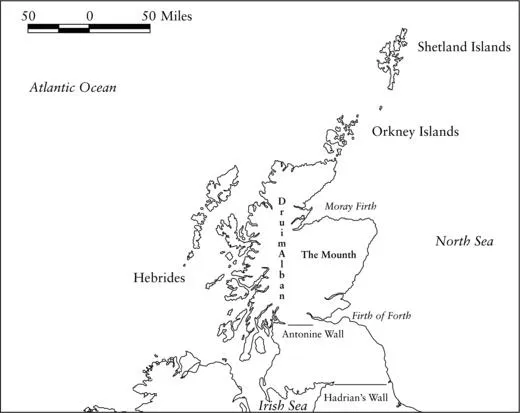
The Romans constructed two walls – today called after the emperors Hadrian and Antonius – as part of their efforts to impose some control over their northern boundary in Britain (see Map 1.1). Building walls was not unique to Britain, of course, and they are found either on their own or in connection with other defenses, as at the Danube. They do show that the Romans felt that their opponents were too dangerous to be left unchecked. The earlier and more southerly barrier is now called Hadrian’s Wall, built between AD 123 and 133 on roughly the same latitude as the southern boundary of Denmark. The more northerly construction, built a generation later, is known today as the Antonine Wall; situated between the inlets of the sea at the firths of Clyde and Forth, it lies farther north than Moscow. The two walls represent different levels of investment as well as longevity. Hadrian’s Wall initially was constructed of stone in the east and turf in the west, with the later replacement of the turf by stone. An entire military zone was created to service it and Hadrian’s Wall not only had portals, but also garrisons that were still stationed there in the fifth century. By contrast the Antonine Wall was built completely of turf and it is essentially a large ditch where the excavated soil was used on the southern side to make the defensive work. Compared with the southern wall, it was built hurriedly and cheaply. The debate continues on how long the Antonine Wall was an active feature of the Roman military establishment, but within the total time of Roman occupation in Britain it was brief, with possibly a total of 20 years of garrisoning. Except for a few decades, Hadrian’s Wall was, so far as the Roman administration was concerned, the divider between barbarism and civilization.
Even though the Antonine Wall was effectively abandoned in the second half of the second century, Roman interest remained north of Hadrian’s Wall. An outpost was the fortress built at Bremenium (now High Rochester) in Northumberland and it was occupied from the first to third centuries. The final Roman occupation of those lands came in the early third century, at the very end of the reign of Emperor Septimus Severus. He led a campaign for which the ostensible reason was to put down attacks from beyond the Wall. The emperor rebuffed efforts for a peaceful settlement in order (so the contemporary historian Herodian claimed) to give his indolent sons experience in warfare. Eager to avoid confrontation, the princes north of Hadrian’s Wall sent envoys to treat with the emperor. Herodian noted that the ambassadors from the northern tribes were clothed only with iron bands round their necks and stomachs; otherwise they wore only tattoos that covered their entire bodies.5 This sounds similar to the claim made three centuries earlier by Julius Caesar, who noted that the Britons wore few clothes and were covered in designs made with blue ink from the woad plant (Isatis tinctoria). Despite the determination of Severus, by the reign of his son Caracalla the imperial administration made Hadrian’s Wall its northern extent.
Herodian’s contemporary Dio gives an ethnic background to the expedition of Septimus Severus. He claims (book LXXVII) that the two principal peoples living north of Hadrian’s Wall were the Caledonians and the Maeatae; the latter lived next to the wall while the former lived beyond them.6 The appearance of the Maeatae is a new grouping from the outline given by Ptolemy. Dio describes both of them as among the principal races of Britons. Both Herodian and Dio remark on the mountains and swamps inhabited by the northern peoples. Dio makes the added comment that the northerners did not touch fish, which seems supported by modern archaeology which has not found much evidence for mounds of fish bones (see chapter 4).
North and South
Anyone who traveled the length of Britain at the end of the third century, on the eve of the first appearance of the use of “Pict” for a people in Britain, would have been aware of a contrast between two general cultural areas marked by Hadrian’s Wall. South of the wall were wide, paved roads that connected towns with markets, houses, government offices, and intersected with other roads leading to ports where ships sailed to continental Europe. North of the wall were a few paths (so inadequate for the Romans that Severus’ troops had to build military roads for their use) leading to scattered fortified encampments usually on elevated ground and known by the Romans as oppida (sing. oppidum). Dio claimed that the inhabitants lived in tents. Security north of Hadrian’s Wall was available to an individual within his own people, while to the south this security was mandated by imperial forces. The south had harbors, grain storage, and land reclamation projects (such as the Roman drainage of the Fen country), but the north had none of these except possibly the last, and then only in a small and irregular fashion. To the south there was also high taxation, requisition of goods, and conscription of men to fight battles far from their homes. In the north there were the goods paid to the local prince which were, in turn, used to maintain his household retinue and distributed among his subjects in public displays of gift-giving. South of Hadrian’s Wall was a culture that borrowed from the great civilizations of the Mediterranean in its art, literature, and scholarship. In the north was the continuation of traditions that had endured for centuries, with an art that was admired by its southern neighbor and a warrior ethos that celebrated the individual. The division is apparent in the perception of Britain after the end of direct imperial administration. The sixth-century historian Procopius (Historia Bellorum, VIII.20) believed that Britain was actually two islands, with the northern part, called Brittia, lying opposite the mouth of the Rhine.7
Equally important was the change in physical geography. There is a greater percentage of arable lands south of Hadrian’s Wall and comparatively fewer to the north. Unlike the broad sweep of the coastal shelf that extended from east to west on a gradually inclining trajectory in Roman Britain; north of Hadrian’s Wall the land suitable for cultivation or prime grazing was confined to coastal strips; the most expansive were found along the eastern coast. Snaking their way round the great sea inlets now known as the firths of Forth, Tay, and Moray, these lands were home to most of the population and are where most of the surviving Pictish symbol stones are found. The lands north of the Wall are much balmier than they should be because of warm water flowing from the Gulf of Mexico known as the Gulf Stream. This current divides at the Pentland Firth with the flow along the eastern coast of Britain known as the North Atlantic Drift. The short growing season in the north meant that the main cereals were barley and oats while crops such as wheat could be grown only in small pockets. What was lacking in arable was compensated by grazing. Hills are prime land for raising livestock, and animals flourished on sloping pastures where their diet was enhanced by the minerals in the grass. There were also fish along the coasts and rivers such as salmon, while shellfish and seaweed were gathered along the shores. Last to be mentioned are the mineral deposits, the copper and iron in Galloway or the gold in Rhynie. But for centuries the single most impressive physical feature was the great Caledonian forest. Not only did it provide wood for building and fuel, but it was an effective defensive barrier because of the difficulty of traveling through it. Interspersed among the woods were wetlands of various types, and together they made any movement slow especially for large numbers of men such as formed the Roman armies.
Hadrian’s Wall was a division in another way, and that was demographically. South of the Wall there had been changes in population as well as construction during the centuries of imperial rule. Population movement is often mentioned but is rarely studied. The Roman strategy of moving troops from one part of the empire to serve in another, the establishment of retirement communities (coloniae) for those troops in disparate lands (Boadicea’s rebellion was directed towards, in part, the veterans settled at the colonia at Colchester), and the general movement of people throughout the empire looking for work, profit, or safety meant that the population of Britain south of Hadrian’s Wall by the fourth century was different from that north of the wall. Inscriptions give some indication of the diversity as they show that civil servants, military officers, and common soldiers upon whom the imperial administration relied were immigrants: Romans, Syrians, and Greeks as well as Gauls and Germans. A section of Hadrian’s Wall from Carrawburgh to Brough on Noe was manned by the cohors I Aquitanorum.
The Picts Appear
The first reference to Picts in Britain comes at the end of the third century AD, three and a half centuries after the establishment of Roman rule in the island. Eumenius, a teacher of rhetoric in Augustodunum (now the city of Autun) in Gaul is believed to be the author of an oration, composed around 296, in praise of a Roman general named Constantius “the Pale” (Chlorus). Constantius had recently returned from Britain to Gaul in the wake of restoring imperial control after the island had fallen away from Rome’s cont...