![]()
Chapter 1
Climate-Based Design Approach for Facades
Building facades perform two functions: first, they are the barriers that separate a building’s interior from the external environment; and second, more than any other component, they create the image of the building. High-performance sustainable facades can be defined as exterior enclosures that use the least possible amount of energy to maintain a comfortable interior environment, which promotes the health and productivity of the building’s occupants. This means that sustainable facades are not simply barriers between interior and exterior; rather, they are building systems that create comfortable spaces by actively responding to the building’s external environment, and significantly reduce buildings’ energy consumption.
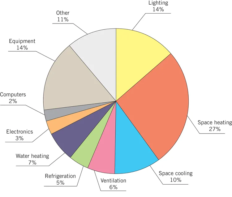
start figure end figure Average energy use for commercial buildings is shown in Figure 1-1. Heating, cooling, lighting, and ventilating interior spaces account for more than half of the energy use. The performance of the building facade can significantly affect the energy consumed by these building systems.
Designers of sustainable facades should use the specific characteristics of a building’s location and climate, as well as its program requirements and site constraints, to create high-performance building envelopes that reduce the building’s energy needs. Climate-specific guidelines must be considered during the design process. Strategies that work best in hot and arid climates are different from those that work in temperate or hot and humid regions.
In this chapter, we look at the different ways of classifying climates, and the characteristics of each climate zone. We also discuss some of the factors that must be considered when designing high-performance sustainable facades, based on climatic environmental characteristics.
Climate Classifications and Types
Climate encompasses the sum of temperature, humidity, atmospheric pressure, wind, rainfall, atmospheric particles, and other meteorological characteristics over extended periods of time. Climate is affected, in varying degrees, by latitude, terrain, and altitude, as well as by nearby mountain ranges or bodies of water. In the United States, for example, the coastal regions of the Pacific Northwest are at the same latitudes as the northern Great Plains. However, due to the tempering effects of ocean currents, its coastal winters are mild compared to the harsh winters on the northern plains. The effects of the Gulf Stream, an ocean current in the northern hemisphere, are responsible for moderating the climate of western Europe. Therefore, countries such as the United Kingdom and France have relatively warm winters, although they are positioned along the same latitude as Canada.
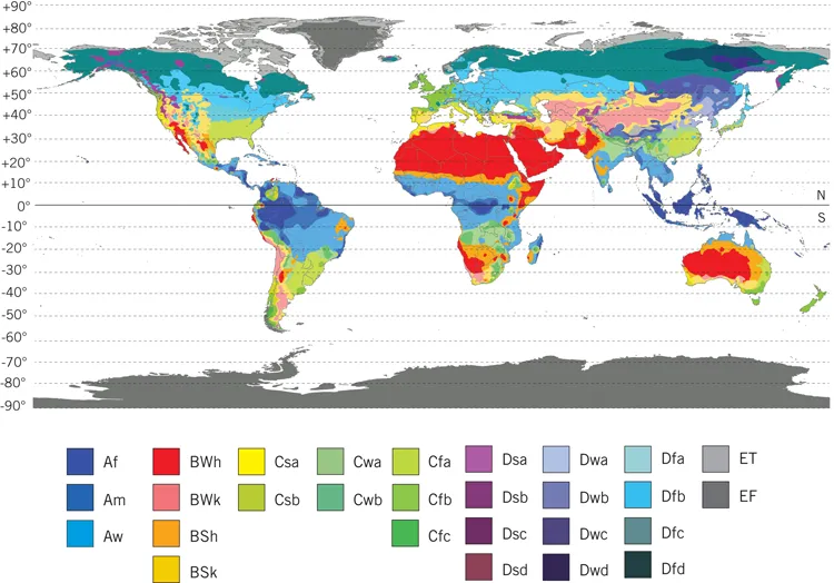
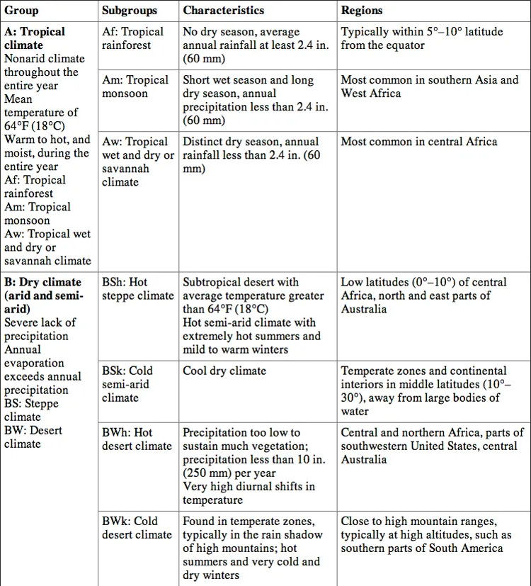
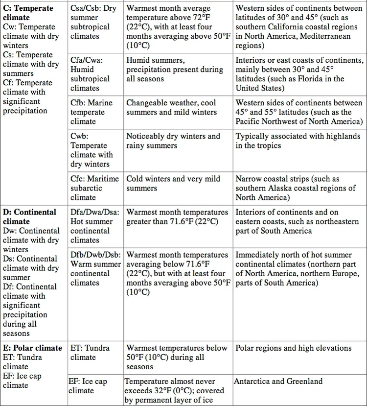
The Koppen Climate Classification System was one of the first methods to categorize different climates. It consists of five major climate groups, each of which is further divided into one or more subgroups. The five primary groups are labeled by the letters A through E, and the subgroups by two- and three-letter codes to designate relative temperature, average precipitation, and (where relevant) native vegetation. The entire world can be classified using this system, as shown in Figure 1-2. Table 1-1 summarizes the basic characteristics of all Koppen climate groups and subgroups, and indicates representative locations.
start figure end figure Table 1-1: Koppen Climate Classification System.
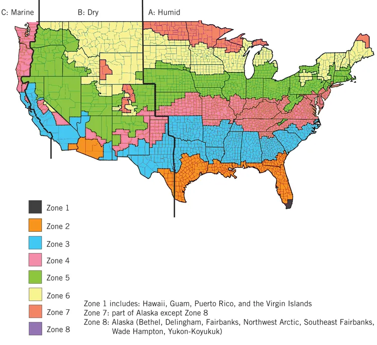
Although the Koppen Classification System can be used to classify climate and environmental conditions for any location in the world, its complexity makes it difficult for designers to use when relating local climate to energy-reduction design strategies. The International Energy Conservation Code (IECC), in conjunction with the American Society of Heating, Refrigerating and Air-Conditioning Engineers (ASHRAE), has developed a climate classification system for the United States that is easier for designers to use. The IECC climate map provides a simplified, consistent approach based on widely accepted descriptions of world climates, as well as the number of cooling and heating degree days for each location. This classification system divides the United States into eight temperature-based climate zones (labeled by numbers 1 to 8), and three subzones based on humidity levels (labeled by letters A, B, and C).
The eight climate zones are:
- Zone 1: very hot
- Zone 2: hot
- Zone 3: warm
- Zone 4: mixed
- Zone 5: cool
- Zone 6: cold
- Zone 7: very cold
- Zone 8: subarctic
The three subcategories based on the location’s humidity are:
- A: humid
- B: dry
- C: marine
Every location in the United States has an associated IECC climate zone and humidity subcategory, as seen in Figure 1-3. The IECC and ASHRAE standards, and the energy codes that are based on them, use this classification system.
Although the IECC climate classification system is useful for designers, and is referred to frequently throughout this book, it has some limitations. The IECC system does not recognize local microclimates. For example, the entire Chicago metropolitan region falls within climate zone 5A. However, the microclimate within a mile of Lake Michigan is different from an inland location such as O’Hare International Airport (one of the weather stations where Chicago weather data are collected). Another example is the city of Los Angeles, which is located in climate zone 3B. However, the microclimate near the Pacific Ocean shore is significantly different from the microclimate of the San Fernando Valley, which is 600 or more feet above sea level and entirely surrounded by hills. For buildings in urban areas, designers should research local microclimate conditions, which may vary from the IECC climate zone description.
start figure end figure Energy performance modeling for buildings is typically based on historical weather data, which are collected over a specific time period, such as thirty years. Temperature, relative humidity, wind speeds, precipitation, and solar radiation data are collected and statistically analyzed to identify typical weather patterns that can be used to predict heating and cooling loads when used in performance modeling. In addition to historic weather data, predictive climate models are currently being developed, which can be used to predict future conditions for a specific location (Lawrence and Chase, 2010). Predictive climate models account for climate changes, impacts of existing and projected greenhouse gas emissions, and slight increases in temperatures. Predicted weather data can be used instead of historical data for modeling a building’s energy consumption, thus taking into account these future changes in climate and their effects on energy consumption.
Climate-Specific Design Guidelines for Facades
Environmental Considerations and Design Criteria
For most buildings, the facade affects the building’s energy budget and the comfort of its occupants more than any other system. To provide occupants with a comfortable and safe environment, a facade must fulfill many functions, such as providing views to the outside, resisting wind loads, supporting its own dead-load weight, allowing daylight to interior spaces, blocking unwanted solar heat gain, protecting occupants from outside noise and temperature extremes, and resisting air and water penetration (Aksamija, 2009).
Designers need to consider the external environment, building orientation, space dimensions, and occupants’ comfort expectations. Table 1-2 shows how air temperature, solar radiation, humidity, wind velocity, noise, ground reflectivity, and dimension and location of external obstacles (e.g., buildings, topography, or plantings) can affect thermal, visual, and acoustic comfort. The relative importance of these criteria will affect design decisions, such as the properties of opaque materials (thickness, density, conduction, reflectivity) and transparent (glazing) materials (thickness, number of l...