![]()
1
Introduction
Philip L. Woodworth, John A. Church, Thorkild Aarup, and W. Stanley Wilson
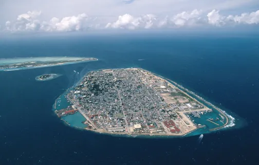
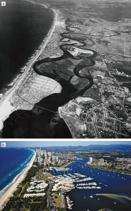
Millions of people are crowded along the coastal fringes of continents, attracted by rich fertile land, transport connections, port access, coastal and deep-sea fishing, and recreational opportunities. In addition, significant populations live on oceanic islands with elevations of only a few meters (Figure 1.1). Many of the world’s megacities, cities with populations of many millions, are situated at the coast, and new coastal infrastructure developments worth billions of dollars are being undertaken in many countries. This coastal development has accelerated over the past 50 years (e.g. Figure 1.2), but it has taken place with an assumption that the stable sea levels of the past several millennia will continue; there has been little consideration of global sea-level rise.
Global sea-level rise and its resultant impact on the coastal zone, one of the consequences of global climate change, has been identified as one of the major challenges facing humankind in the 21st century. Impacts on the environment, the economy, and societies in the coastal zone will likely be large (e.g. Chapters 2 and 3 of this volume; Intergovernmental Panel on Climate Change (IPCC) Working Group 2 Report1; Stern Review of the Economics of Climate Change2; Millennium Ecosystem Assessment3). However, estimates of the timescales, magnitudes, and rates of future sea-level rise vary considerably, partly as a consequence of uncertainties in future emissions and the associated climate response, but also because of the lack of detailed understanding of the processes by which the many contributions to sea-level change will evolve in a future climate. The study of historical records of sea level and their proxies offers a means for understanding and quantifying the many uncertainties, as well as determining how a global monitoring system suitable for improved understanding of sea level change in the future might be established.
Minimizing future coastal impacts will require mitigation of greenhouse gas emissions, to avoid the most extreme scenarios of sea-level rise, and adaption to the rise that actually takes place. Optimal planning and policy decisions by governments around the world as well as local-adaption decisions are currently constrained by our inadequate understanding of the response of sea level to increasing greenhouse gas concentrations. It is therefore imperative to identify and quantify the causes contributing to the presently observed sea-level change, in order that better models can be developed and more reliable predictions can be provided. Planners and decision-makers will need long-term forecasts of global sea-level rise, and also information on how short-term variability and long-term change of sea level will be expressed at regional and local scales.
In June 2006, a workshop was organized under the auspices of the World Climate Research Programme (WCRP) at the Intergovernmental Oceanographic Commission of United Nations Educational, Scientific and Cultural Organization (UNESCO) in Paris, with the aim of identifying the major uncertainties associated with sea-level rise and variability, as well as the research and observational activities needed for narrowing those uncertainties, thus laying the basis for improved projections of sea-level rise during the 21st century and beyond. It was sponsored by 34 organizations, and was attended by 163 scientists (from 29 countries) representing a wide range of expertise. The workshop also had the aim of obtaining consensus on sea-level observational requirements for the Global Earth Observation System of Systems (GEOSS) 10-Year Implementation Plan. Progress in major areas of research, their associated uncertainties and recommendations for future work were summarized in position papers circulated prior to and then discussed during the workshop. An interim report on research and observational priorities was prepared and is available4 (see also Church et al. 2007). Subsequently, the position papers were revised, expanded, and peer-reviewed to constitute the chapters of this book. The chapters were then edited and assembled to provide a coherent overview of the field of sea-level rise. Additional chapters were included to provide a review of future observational requirements and a synthesis of scientific findings.
This book is intended to complement the IPCC scientific assessments, by starting with the uncertainties the IPCC identified in sea-level rise and variability, and then focusing on the scientific and observational requirements needed to reduce those uncertainties. While the book provides consensus estimates of the present rate of global mean-sea-level rise, it does not provide new sea-level projections. In contrast, the IPCC Assessment does include projections, but does not provide the research and observational requirements needed to reduce uncertainties in those projections. Also, there are additional research and observational requirements relating to the impacts of sea-level rise which are beyond the scope of this book. These include information on the impact of waves on the coastline, including coastal inundation and erosion issues, information on local land motion and sediment budgets, information on the natural coastal environment, and the societal response to sea-level variability and rise.
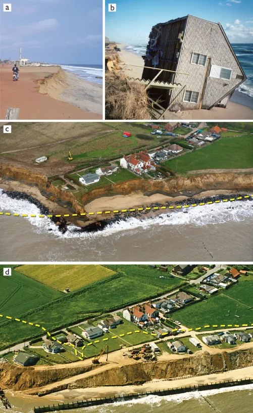
Chapters 2 and 3 contain contributions on the topic of the impacts of sea-level rise. In many parts of the world, coastal developments and infrastructure are becoming increasingly vulnerable to sea-level rise and extremes (for example Figure 1.3), as Hurricanes Katrina, Sidr, and Nargis have demonstrated so clearly. The purpose of including these two chapters, which discuss representative major impacts, is to put the research described in subsequent chapters into context and to make it clear that it has great value, not only in a scientific context, but also to society in general.
The impacts of sea-level change occur at the local level and are a result of changes in relative sea level. These relative changes occur as a result of large-scale, basin-wide, and global-scale changes in sea level and land levels, as well as regional and local changes. These changes in sea and land levels compound the impacts from coastal storm surges and high wave conditions. Chapter 2 explains that local geological factors including those associated with seismic events, compaction of coastal sediments, and loss of coastal sediment supplies are important and need to be considered together with regional sea-level rise. Consideration of these effects requires impact studies on a variety of spatial scales.
Chapter 4 and the following chapters contain a detailed and systematic discussion of aspects of sea-level change. They have the aim of improving our understanding of the uncertainties associated with the various contributions to observed sea-level change, so that ultimately those uncertainties can be reduced and the observed sea-level rise be adequately explained, thereby removing what the eminent oceanographer Walter Munk (2002) has called the “enigma of 20th century sea level rise” (the inability to account for the observations).
It should be no surprise to anyone that global mean sea level is changing, and has always changed on a range of timescales. Chapter 4 discusses the evidence for changes on millennial and multicentury timescales with the use of geological and archaeological data, thereby providing a context for the modern-day observations summarized in Chapter 5.
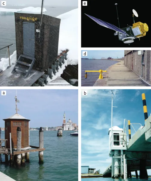
These two chapters explain that a number of more precise observational techniques have been developed in recent years. Examples include new techniques for dating geological sea-level indicators (Figure 1.4) and methods for exploiting salt-marsh information to determine sea-level changes of the relatively recent past (within a few hundred years). Improvements in observations of sea level by tide gauges (Figure 1.5) include the use of advanced geodetic techniques (Global Positioning System (GPS), absolute gravimetry, and Doppler Orbitography and Radiopositioning Integrated by Satellite (DORIS)) to monitor vertical movements of the land on which they are located and thereby remove the effects of land-level changes in their records. Since 1993, tide-gauge data have been complemented by high-quality measurements from space by satellite altimetry (Figure 1.5) and space gravity (see Figure 1.10, below). Satellite altimetry has revolutionized our understanding of oceanography and sea-level rise. High-quality satellite-altimeter missions provide direct, near-global observations of the rate of sea-level rise and its temporal and spatial variability. Continuity between missions and careful and rigorous intercomparison of different missions and of satellite data with in situ observations is critical to gaining maximum benefit from this investment. Each observational technique, whether in situ or space-based, contains its temporal and spatial inadequacies which result in uncertainties in estimates of the rates of global sea-level change.
The main processes responsible for sea-level change, each of which are associated with climate variability and change, are internal changes in the ocean due to changes in the density of sea water, inputs to the ocean of additional water due to losses of ice from glaciers, ice caps, and ice sheets, modifications in the exchanges of water between ocean and land storage, and smaller modifications in the exchanges between ocean and atmosphere. The internal ocean changes are called steric changes. They result from modifications in the density of sea water throughout the water column and can be considered as a combination of thermosteric and halosteric change, due to changes in temperature and salinity respectively, with the latter an order of magnitude smaller than the former in its importance to long-term, global sea-level rise. Steric changes are not globally uniform but have a spatial distribution which at many tropical and mid-latitude locations reflects changes in heat content.
The ocean temperature and salinity data sets from which steric changes are computed have their own temporal and spatial biases, with increasingly large gaps in coverage as one goes back in time, with relatively few measurements until recent years in the Southern Hemisphere. A different mix of observational methods (fixed moorings, research ships, ships of opportunity, profiling floats; Figure 1.6) have been used at different times, with consequent changes in sampling both in geographical position and vertically through the water column, and with varying accuracies dependin...