- Presents the most detailed and current work to date
- Written in a style that is both intelligent and accessible
- Fully illustrated with original drawings and photographs
- Relevant and information for a broad audience working on organic sediments in various environments
eBook - ePub
Geomorphology of Upland Peat
Erosion, Form and Landscape Change
- English
- ePUB (mobile friendly)
- Available on iOS & Android
eBook - ePub
About this book
The Geomorphology of Upland Peat offers a detailed synthesis of existing literature on peat erosion, incorporating new research ideas and data from two leading experts in the field.
Trusted by 375,005 students
Access to over 1.5 million titles for a fair monthly price.
Study more efficiently using our study tools.
Information
Chapter One
Introduction
1.1 The Aims of this Volume
The aim of this monograph is to report recent work on the geomorphology of upland peatlands, and review current understanding of erosion processes and the long-term evolution of eroding upland systems. The book is written not only for peatland geomorphologists but also to provide a useful reference on current understanding of the physical functioning of peat landsystems for those working on their ecology, whether from a research perspective, or involved in practical management. In essence this book provides a state-of-the-art appraisal of understanding of the geomorphology of upland peats and demonstrates the importance of a geomorphological perspective for the understanding and management of these important and sensitive upland systems.
In this chapter we outline the scope of the book and provide a framework for evaluating the geomorphology of upland peat landsystems. First we consider the thematic and geographical context of the study. This is followed by explanation of some basic terminology and definitions used to describe peat and the classification of peatlands. We then discuss the geography of blanket mire complexes and examine patterns and causes of peat erosion. This is placed in the context of the evolution of peatland geomorphological science culminating in the development of a peat landsystem model which is used as a general framework for the book as a whole.
1.1.1 Thematic coverage
Upland peat is the residual product of the functioning of a series of fascinating and highly complex moorland ecosystems. As such it is hardly surprising that writing about peat landsystems has been dominated by biologists and ecologists (e.g. Gore 1983). Central to understanding these wetland systems has been an appreciation of their hydrology and there is an extensive body of literature describing the hydrological functioning of upland peatlands (see for example Ivanov 1981; Ingram 1983; Hughes and Heathwaite 1995b; Baird et al. 2004). However, in addition to their ecological functioning, upland peats are important terrestrial material stores. The slow continual accumulation of peat in intact peat bogs preserves a prehistoric archive interrogated by palaeo-ecologists and archaeologists alike (Charman 2002). When environmental conditions change, whether naturally or through human intervention, the continual accumulation of peat can be interrupted, and when the surface vegetation is stressed or removed the deep accumulations of organic sediment may begin to erode. Under these circumstances both the morphology and the ecological and hydrological functioning of the system becomes strongly influenced by erosion processes. This is an aspect of peatland functioning which has been relatively little studied.
This volume covers the hydrologically and ecologically controlled forms of intact upland mires but the majority of the book is concerned with the geomorphology of peatlands where processes of physical erosion are dominant. This focus is pertinent to mire management and conservation since it is in eroding peatlands where an understanding of their geomorphology is central to contemporary management and prediction of future mire condition.
1.1.2 Geographical context
The core of the book is focused on the authors’ work on the eroding peatlands of northern Britain, particularly in the Pennine ranges, but every effort has been made to place this work in a wider context with reference to the most up-to-date work on upland mire systems. The United Kingdom (UK) has the most extensive erosion of upland peat in the world, and the vast majority of academic work on the causes, mechanisms and consequences of peat erosion is based on UK sites. Approximately 90 per cent of the published work on the geomorphology of upland peat refers to material derived from work in the British Isles. This fact, together with the geographical location of the authors’ work, inevitably means that there is a strong UK focus to this book. However, the implications of what is reported extend beyond concerns with the management of erosion in the UK.
There is much debate over the causes of the extensive erosion in UK uplands but whilst severe land-use pressure has certainly been a factor, there is strong circumstantial evidence that climatic changes have played a major role. Increased storminess (Stevenson et al. 1992; Rhodes and Stevenson 1997) and desiccation of the mire surface (Tallis 1995) are both implicated and are effects which might be exacerbated across much of the world’s northern peatlands under projected global climate changes (Houghton et al. 2001). UK peatlands are therefore an important field laboratory for the development of a thorough understanding of the dynamics of eroding peatlands. This will be essential in developing strategies to mitigate the possibility of enhanced physical degradation of wider northern peatlands in response to climate change, and the major effects on biodiversity, the carbon cycle and water quality which this would entail.
1.2 Terminology, Definitions and Peatland Geomorphology
There are several peatland classification schemes with terminology varying between nationalities and professional communities. Excellent summaries of the main classification types are given by Moore (1984) and Charman (2002). In this section the peatland terminology adopted in this volume is defined and the main types of upland peatland considered are identified.
1.2.1 Definitions of peat
Peat is an accumulation of the partly decomposed or undecomposed remains of plant material. There is a large range of peat types whose main properties vary depending primarily on the type of plant material composing the bulk of the organic matter and the degree of humification of the material. In most common soil classification schemes peat is usually treated as a distinct class. Even under specific organic soil classifications, peat is a distinct end member (Myślińska 2003). Under the widely accepted USDA Soil Taxonomy, organic soils form one of the main 12 soil orders and are known collectively as Histosols. Histosols contain at least 20–30 per cent organic matter by weight and are more than 0.4 metres thick. They have low bulk densities and high carbon contents. These soils occupy approximately 1.2 per cent of the ice-free land surface globally and are usually referred to as peats or mucks (McDaniel 2005). Peat deposits are also normally defined in terms of the depth of peat present in a particular setting but local definitions may vary. In a British and Irish context the criteria for separating peat from mineral soil varies. The Soil Survey of England and Wales uses 0.4 metres as the minimum depth for a peat deposit (Cruickshank and Tomlinson 1990), whilst 0.5 metres is used in Scotland (Burton 1996), and 0.45 metres (undrained) in Ireland (Bord na Móna 2001).
1.2.2 The physical and geotechnical properties of peat
Consideration of the physical processes of erosion affecting peatland surfaces requires an understanding of the physical characteristics of peat as an earth material. Many of the challenges of a process-based approach to the geomorphology and hydrology of peatlands stem from the unusual properties of peat. Hobbs (1986) provides an excellent review of the properties and behaviour of peat. In this account Hobbs refers to peat as an ‘ordinary extraordinary material’ due to its unusual characteristics as an earth surface material (Table 1.1). For example, some properties of peat are similar to the behaviours of clay, but due to the extremely high water content of the peat, simple relations with material strength cannot be easily established (Landva et al. 1983). The material structure of peat greatly affects the hydraulic properties and strength of the deposit (Hobbs 1986). Although peat varies enormously, a ‘typical’ peat might be composed, by volume, of 85% water, 2% ash or mineral material, 8% organic material, and 5% air. The bulk density of the peat will increase as the organic matter becomes more decomposed but conversely the water content of peat decreases with decomposition. It is therefore essential to have a means of describing the different forms of peat so that the behaviour of these materials can be properly characterized.
Table 1.1 Key properties of peat and examples of the importance of these for peatland geomorphic processes. This is not a comprehensive survey. It is included to demonstrate the important link between the peat material properties and controls on surficial processes
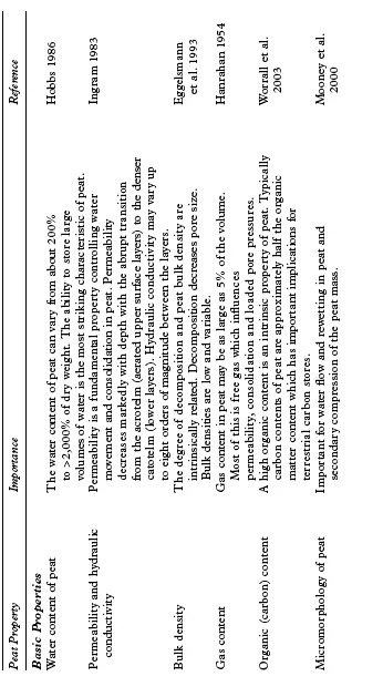
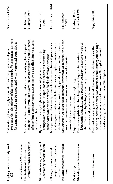
Several peat description schemes have been developed. However, the von Post classification (von Post 1924) is widely used to provide a semiquantitative description of the physical, chemical and structural properties of peat deposits. The scheme is based on semi-quantitative assessments of the principal plant remains, degree of humification, water content, fibre content and woody fragments. Hobbs (1986: 78–9) provides a succinct description of the main method. The von Post approach provides a rapid assessment method for characterizing peat properties. Table 1.1 considers examples of some of these key properties and identifies the important interrelationships between the basic peat components (phases) and the importance of these for the peatland geomorphic processes which are considered in more detail in subsequent chapters of this book.
1.2.3 Peatland classification
The term peatland is used, in this volume, to refer to all landscapes where the dominant surficial deposits are accumulations of organic matter (peat) in excess of 0.4 metres depth. The literature on the classification of peat landscapes is extensive but perhaps the most commonly adopted distinction is based on the source of water input to the peat mass. A distinction is made between bogs (ombrotrophic mires) and fens (minerotrophic mires) where the former are rainwater fed systems, typically acidic and nutrient poor, and the latter are groundwater fed, and typically circum-neutral with higher nutrient status (Hughes and Heathwaite 1995a). The term mire is used to refer to all forms of peatland, both bog and fen, and is the most appropriate term for many of the upland peatlands considered in this volume. Although typically dominated by ombrotrophic mire types these are complex upland systems with variable nutrient status. The definition adopted in this volume is closely related to the original definitions of mire and bog by Godwin (1941, 1956) which emphasize the nature of the sediments and the hydrological context and are appropriate to considerations of upland mires as geomorphological and hydrological systems.
The term ‘upland’ is widely used but needs clear definition in the context of this work. We conceive of the uplands as wildlands or areas where agriculture is extensive. As such we are working with a rather UK-specific definition of upland, akin to that of Ratcliffe (1977), of uplands as lands beyond the limit of enclosed cultivation. However, peatland landscapes of the type we are concerned with are not confined to the UK or indeed to a particular altitudinal band. They are often associated with resistant lithologies. The resultant thin soils tend to produce marginal lands, and indeed thin soils over impermeable bedrock tend to produce the waterlogged conditions favouring peat formation. Thus the low altitude peatlands of Newfoundland, Tasmania, the Shetlands and the Falkland Islands would fall within our definition of upland.
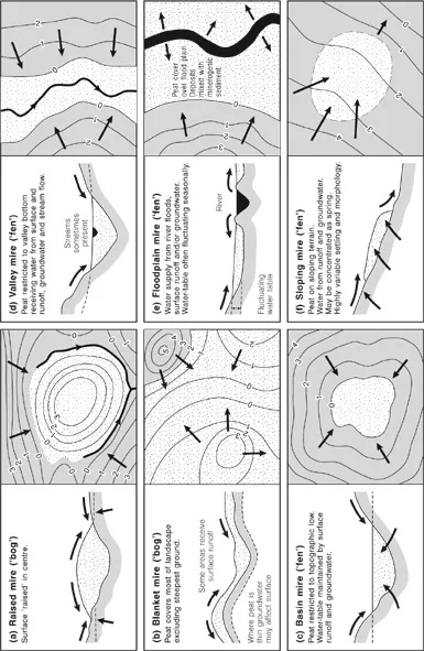
Hughes and Heathwaite (1995a) classify UK mires on a morphological basis into soligenous (sloping) mires, basin mires, valley mires, floodplain mires, raised mires and blanket mires. Charman (2002) suggests that this classification represents a generic hydro-morphological classification with broad applicability (Figure 1.1). The most widespread upland peat type is the blanket mire. Blanket bog is a term first defined by Tansley (1939) (Wheeler and Proctor 2000), to describe widespread ombrotrophic mire which follows the underlying topography like a blanket. Blanket bog is extensive and may therefore link other mire types into a continuous upland wetland system. A blanket bog may incorporate former basin mires in topographic low points and areas of raised mire formed either on summits, interfluves, or developed from former areas of basin mire. Where blanket peat is dissected or encompasses lines of pre-peat drainage then valley or floodplain mires form part of the complex, and where valley-side springlines are exposed soligenous mires may also form. Lindsay (1995) describes these mire assemblages, which span the full range of mire types identified by Hughes and Heathwaite (1995a), as blanket mire complexes. This usage is broadly synonymous with what we have termed upland mire complexes. Blanket peat is a necessary component of an extensive upland mire complex and in this volume, for reasons of style and respect for local usage, the terms upland mire complex, blanket mire complex and blanket peatland are used interchangeably.
Figure 1.1 Hydro-topographical classification of mire types (after Charman 2002)
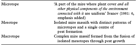
Lindsay (1995: 22) notes that ‘mire complexes are most frequently encountered in the uplands where several hydro-topographical units … fuse to form an extensive complex cloaking the landscape with peat.’ To understand what Lindsay means by hydro-topographical units it is necessary to first review the basic classification of peatland landforms produced by Russian peatland scientists and summarized in Ivanov (1981) (Table 1.2). In the context of upland peatlands the macrotope is the upland mire complex identified above and the mesotopes which combine to form this macrotope might reasonably be characterized as any of the mire types identified by Hughes and Heathwaite (1995a). The mesotope therefore is essentially a unit at the scale of peat landforms and the macrotope describes the peatland landscape. In a sense the geomorphology of a landscape where peat formation occurs is the prime control over the mire type produced since local slope is the major determinant of the direction of groundwater flow relative to the centre of mire growth and consequently of the division between fens and bogs. Lindsay (1995) uses an explicitly geomorphological framework to subdivide elements of the blanket bog type following Ivanov’s (1981) assertion that mire classification should include a geomorphological element. Lindsay describes watershed mires (probably better defined as summit mires), spur mires, saddle mires and valley side mires defined by their topographical setting. These hydro-topographical units are essentially mire mesotopes classified geomorphologically. Figure 1.2 illustrates the combination of a series of these hydro-topographical units to form an upland mire complex (macrotope).
Figure 1.2 Combination of hydro-topographical units to form an upland mire complex (redrawn after Lindsay 1995)
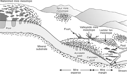
Table 1.2 Classification of scales of mire landforms (after Ivanov 1981)
At a smaller scale Lindsay et al. (1988) identify seven major microforms associated with UK blanket peatlands. These can be classified as follows:
Hydro-ecological microforms
hummocks
ridges, high or low
hollows, Sphagnum or mud-bottomed
pools, permanent or ephemeral
Geomorphological microforms
erosion gullies
erosion haggs
peat mounds
hummocks
ridges, high or low
hollows, Sphagnum or mud-bottomed
pools, permanent or ephemeral
Geomorphological microforms
erosion gullies
erosion haggs
peat mounds
The hydro-ecological microforms are largely controlled by the close interaction of hydrological and ecological processes on the mire surface (Belyea and Clymo 1998; Bragg 2002; Laine et al. 2004). These processes have formed the focus of the vast majority of previous academic work on upland peatlands. The geomorphological microforms and the physical processes which control them have received much less attention. Therefore, in terms of the classification of upland peats outlined above the focus of this volume is the geomorphology of upland blanket mire complexes.
1.3 The Geography of Blanket Mire Complexes
As primarily ombrotrophic systems, the distribution of blanket mire is closely controlled by climate. All mire systems require a positive water balance for their long-term growth and maintenance. In ombrotrophic systems the key components of the water balance are precipitation inputs and losses by evapotrans...
Table of contents
- Cover
- Half Title Page
- Title Page
- Copyright Page
- Dedication
- Series Editors’ Preface
- Acknowledgements
- Figure and Table Acknowledgements
- Chapter 1: Introduction
- Chapter 2: The Hydrology of Upland Peatlands
- Chapter 3: Sediment Production
- Chapter 4: Fluvial Processes and Peat Erosion
- Chapter 5: Slope Processes and Mass Movements
- Chapter 6: Wind Erosion Processes
- Chapter 7: Peat Erosion Forms – From Landscape to Micro-Relief
- Chapter 8: Sediment Dynamics, Vegetation and Landscape Change
- Chapter 9: Implications and Conclusions
- References
- Index
Frequently asked questions
Yes, you can cancel anytime from the Subscription tab in your account settings on the Perlego website. Your subscription will stay active until the end of your current billing period. Learn how to cancel your subscription
No, books cannot be downloaded as external files, such as PDFs, for use outside of Perlego. However, you can download books within the Perlego app for offline reading on mobile or tablet. Learn how to download books offline
Perlego offers two plans: Essential and Complete
- Essential is ideal for learners and professionals who enjoy exploring a wide range of subjects. Access the Essential Library with 800,000+ trusted titles and best-sellers across business, personal growth, and the humanities. Includes unlimited reading time and Standard Read Aloud voice.
- Complete: Perfect for advanced learners and researchers needing full, unrestricted access. Unlock 1.5M+ books across hundreds of subjects, including academic and specialized titles. The Complete Plan also includes advanced features like Premium Read Aloud and Research Assistant.
We are an online textbook subscription service, where you can get access to an entire online library for less than the price of a single book per month. With over 1.5 million books across 990+ topics, we’ve got you covered! Learn about our mission
Look out for the read-aloud symbol on your next book to see if you can listen to it. The read-aloud tool reads text aloud for you, highlighting the text as it is being read. You can pause it, speed it up and slow it down. Learn more about Read Aloud
Yes! You can use the Perlego app on both iOS and Android devices to read anytime, anywhere — even offline. Perfect for commutes or when you’re on the go.
Please note we cannot support devices running on iOS 13 and Android 7 or earlier. Learn more about using the app
Please note we cannot support devices running on iOS 13 and Android 7 or earlier. Learn more about using the app
Yes, you can access Geomorphology of Upland Peat by Martin Evans,Jeff Warburton in PDF and/or ePUB format, as well as other popular books in Physical Sciences & Geography. We have over 1.5 million books available in our catalogue for you to explore.