What is atmospheric pressure? How does latitude indicate the type of climate a specific place will have? Where are volcanic eruptions or strong earthquakes most likely to occur? With Physical Geography: A Self-Teaching Guide, you'll discover the answers to these questions and many more about the basics of how our planet operates.
Veteran geography teacher Michael Craghan takes you on a guided tour of Earth's surface, explaining our planet's systems and cycles and their complex interactions step by step. From seasonal changes to coastal processes, from effluvial basins to deep sea fissures, Craghan puts the emphasis on comprehension of the topics. He also includes more than 100 specially commissioned illustrations and 50 photographs to help clarify difficult concepts. The clearly structured format of Physical Geography makes it fully accessible, providing an easily understood, comprehensive overview for everyone from the student to the amateur geographer to the hobbyist.
Like all Self-Teaching Guides, Physical Geography allows you to build gradually on what you have learned-at your own pace. Questions and self-tests reinforce the information in each chapter and allow you to skip ahead or focus on specific areas of concern. Packed with useful, up-to-date information, this clear, concise volume is a valuable learning tool and reference source for anyone who wants to improve his or her understanding of physical geography.
Trusted by 375,005 students
Access to over 1 million titles for a fair monthly price.
• Earth rotates on its axis, which generates night and day.
• Latitude is an angle measurement used to identify a location on the surface of Earth.
• It takes Earth one year to revolve around the Sun.
• Seasons are caused by how the tilt of Earth’s axis affects the orientation of the planet as it revolves around the Sun.
• Hours of daylight are determined by Earth’s orientation with the Sun.
Size and Shape of Earth
Earth is a planet—it is a large body that moves around the Sun. It is not a perfect sphere, but Earth is a spherically shaped object. Earth has these approximate dimensions:
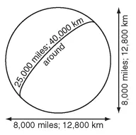
Figure 1.1. Earth is about 4,000 miles from its center to the surface (8,000-mile diameter) and approximately 25,000 miles around.
• Radius: 4,000 miles (6,400 km)
• Diameter: 8,000 miles (12,800 km)
• Circumference: 25,000 miles (40,000 km)
These values can vary slightly due to differences in surface topography and because Earth is not an exact sphere. If you could drive nonstop around the equator at 60 mph it would take seventeen days to make the trip.
What is the approximate distance around Earth (its circumference)? ________________
Answer: 25,000 miles (40,000 km)
Rotation, Poles, Equator
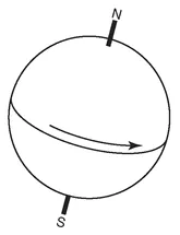
One feature of this planet is its rotation—it spins. It takes one day for Earth to rotate on its axis (one day exactly, because that is the definition of a day: one spin on its axis). Spinning leads to a reference system based on the axis of rotation. The North and South Poles are at the ends of the axis of rotation and thus can be used as unique reference points. If Earth did not spin (and thus had no rotation axis), then any place would be as good as any other for describing location.
Figure 1.2. Because Earth rotates, we can identify the North Pole and the South Pole as special spots. A place on Earth will rotate once around and find itself back in the same position a day later.
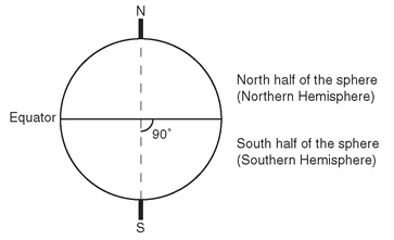
Rotation also produces another feature of interest: the equator. The equator is in a plane perpendicular to the axis of rotation, and it divides the spherical Earth into halves. All of the points on one side of the equator are closer to the North Pole than to the South Pole. All of the points on the other side are closer to the South Pole. The half of Earth closest to the North Pole is called the Northern Hemisphere (half a sphere). The half of Earth closest to the South Pole is the Southern Hemisphere.
Figure 1.3. The equator is in a plane perpendicular to the axis of rotation, and it separates Earth into two halves: the Northern Hemisphere and the Southern Hemisphere.
What is the line that divides Earth into a half that is closer to the North Pole and another half that is closer to the South Pole? ________________
Answer: the equator
Latitude
Once the two poles and the equator have been identified, then a system of measurement called latitude can be established. Latitude is an angle measurement from the equator to a point on Earth’s surface. The angle is measured from the center of Earth at the point where the rotation axis intersects the plane of the equator.
The latitude system has some simple qualities:
• All points on the equator are 0° away from the equator.
• The North Pole is 90° away from the equator.
• The South Pole is 90° away from the equator.
• If the angle is measured toward the North Pole it is called north latitude.
• If the angle is measured toward the South Pole it is called south latitude.
• North and south are important! You must state whether a place has north or south latitude to properly identify it.
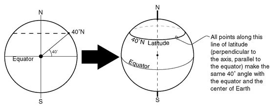
Figure 1.4. All points that are the same angle away from the equator and the center of Earth have the same latitude.
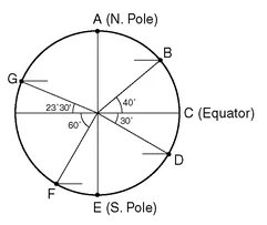
Figure 1.5.
What are the latitudes of points A, B, C, D, E, F, and G in Figure 1.5? ________________
Answer: A = 90°N, B = 40°N, C = 0°, D = 30°S, E = 90°S, F = 60°S, G = 23°30’N
Revolution around the Sun
At the same time that it is rotating on its axis, Earth also is following a path around the Sun. Earth is a planet that rotates on its axis and also revolves around the Sun.
Rotate = axis = 1 day
Revolve = orbit = 1 year
It takes one year for Earth to revolve around the Sun (one year exactly, because that is the definition of a year: one trip around the Sun). This journey also takes 365¼ days (i.e., one year). So Earth will rotate on its axis 365¼ times in the time it takes for the planet to go around the Sun and return to its departing point.
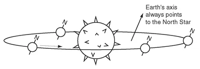
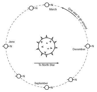
The path that Earth travels along is an ellipse—but it is very close to being a circle. The nearly circular path is used to define a geometric feature called the plane of revolution. Although the planet orbits within the plane of revolution—this is going to affect almost everything on Earth—Earth’s axis of rotation (the line running from the South Pole through the North Pole) always points toward the North Star.
Figure 1.6. It takes Earth one year to complete its nearly circular revolution around the Sun. Earth’s axis is always tilted toward the North Star.
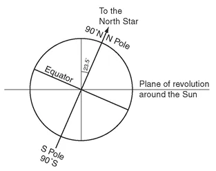
For the North Pole to be continuously directed toward the North Star, Earth’s axis has to be tilted 23½° away from perpendicular to its plane of revolution around the Sun. The direction and angle of the tilt will always be the same: the axis is always aligned toward the North Star. As a result of its constant aim to the North Star, the alignment of the axis with the Sun is always changing. For part of its revolution around the Sun, Earth’s North Pole generally leans toward the Sun, and for the other part of a year it leans away from the Sun.
• In December, the North Pole leans away from the Sun.
• In June, the North Pole leans toward the Sun.
Figure 1.7. Earth’s axis is tilted 23½° away from perpendicular to its orbit in the plane of revolution.
Figure 1.8. In this view from above Earth’s plane of revolution you can see that the North Pole is always pointed toward the North Star. This causes the orientation of Earth with respect to the Sun to always be changing.
• In March and September, the line from Earth to the Sun is perpendicular to the South Pole-North Pole axis.
Because the North Pole is always pointing to the North Star, Earth’s Northern Hemisphere is directed ________________ the Sun in June and ________________ the Sun in December.
Answer: toward; away from
Tilt and Reference Latitudes
This tilt of Earth’s axis creates five special latitude lines. These five lines are the equator, two “tropics,” and two “circle...
Table of contents
Title Page
Copyright Page
Acknowledgments
Introduction
Chapter 1 - Earth and Sun
Chapter 2 - Insolation and Temperature
Chapter 3 - The Atmosphere and Atmospheric Water
Chapter 4 - Pressure and Wind
Chapter 5 - General Circulation of the Atmosphere
Chapter 6 - Air Masses and Storms
Chapter 7 - Climate
Chapter 8 - Plate Tectonics
Chapter 9 - Plate Interactions
Chapter 10 - Volcanoes and Earthquakes
Chapter 11 - Weathering
Chapter 12 - Groundwater
Chapter 13 - Streams
Chapter 14 - Wind and Ice
Chapter 15 - Waves and Tides
Appendix 1: The Ancient Explanation of Earth-Sun Relationships
Appendix 2: Coriolis Force
Index
Frequently asked questions
Yes, you can cancel anytime from the Subscription tab in your account settings on the Perlego website. Your subscription will stay active until the end of your current billing period. Learn how to cancel your subscription
No, books cannot be downloaded as external files, such as PDFs, for use outside of Perlego. However, you can download books within the Perlego app for offline reading on mobile or tablet. Learn how to download books offline
Perlego offers two plans: Essential and Complete
Essential is ideal for learners and professionals who enjoy exploring a wide range of subjects. Access the Essential Library with 800,000+ trusted titles and best-sellers across business, personal growth, and the humanities. Includes unlimited reading time and Standard Read Aloud voice.
Complete: Perfect for advanced learners and researchers needing full, unrestricted access. Unlock 1.4M+ books across hundreds of subjects, including academic and specialized titles. The Complete Plan also includes advanced features like Premium Read Aloud and Research Assistant.
Both plans are available with monthly, semester, or annual billing cycles.
We are an online textbook subscription service, where you can get access to an entire online library for less than the price of a single book per month. With over 1 million books across 990+ topics, we’ve got you covered! Learn about our mission
Look out for the read-aloud symbol on your next book to see if you can listen to it. The read-aloud tool reads text aloud for you, highlighting the text as it is being read. You can pause it, speed it up and slow it down. Learn more about Read Aloud
Yes! You can use the Perlego app on both iOS and Android devices to read anytime, anywhere — even offline. Perfect for commutes or when you’re on the go. Please note we cannot support devices running on iOS 13 and Android 7 or earlier. Learn more about using the app
Yes, you can access Physical Geography by Michael Craghan in PDF and/or ePUB format, as well as other popular books in Physical Sciences & Geography. We have over one million books available in our catalogue for you to explore.