![]()
PART I
INTRODUCTION
Volcanology is a specialized field of geology – the science of volcano study. Volcanologists are not only the scientists who study volcanoes (mostly geologists, geophysicists, geochemists, and geodesists), but also the devoted technicians who spend their lives monitoring volcanoes at observatories. To become a volcanologist, one must certainly study a great deal of geology and other physical science, but the title cannot be meaningfully earned by reading books or bestowed by any university. Volcanoes themselves are the best teachers of volcanology, and the most respected volcanologists are those who have studied volcanoes in the field for many years. Volcanologists strive for a better understanding of volcanoes, and are concerned about how their work will contribute to human social needs. Protecting life and property, utilizing the tremendous stores of volcanic energy for society, and perhaps learning to lessen the dangers of certain volcanic phenomena – these are noble goals to strive for!
This Part contains only one chapter, an important one that begins with introductory narratives for a clearer understanding of what volcanic eruptions are like to experience first-hand, discusses some basic terminology, and includes a section on the history of our young science.
![]()
Chapter 1
Eruptions, Jargon, and History
Volcanoes assail the senses. They are beautiful in repose and awesome in eruption; they hiss and roar; they smell of brimstone.
Their heat warms, their fires consume; they are the homes of gods and goddesses.
(Robert Decker 1991)
Volcanic eruptions are the most exciting, awe-inspiring phenomena of all the Earth’s dynamic processes, and have always aroused human curiosity and/or fear. Volcanoes, volcanic rocks, and volcanic eruptions come in many varieties, however, and to begin to understand them one must absorb a great amount of terminology and information. We’ll get to that material soon enough, but first let’s explore what volcanoes are really like! The facts and figures in subsequent chapters could prove boring if you lose sight of the fact that each volcano and every piece of volcanic rock that you will ever study was born of fire and fury, and that all volcanic rocks are ultimately derived from underground bodies of incandescent liquid called magma – molten rock. Every volcanic mountain or rock that you will ever see or touch once knew terrible smells and sounds that you must close your eyes to imagine.
French volcanologists loosely divide the world’s volcanoes into two general types: Les volcans rouges (red volcanoes) and Les volcans gris (grey volcanoes). “Red volcanoes” are those volcanoes that are mostly found on mid-oceanic islands and are characterized by effusive activity (flowing red lava). The “grey volcanoes,” generally found near continental margins or in island chains close to the edges of continents, are characterized by explosive eruptions that cover vast surrounding areas with grey ash. This is a pretty good rough classification for most volcanoes, although there are many that have had both effusive and explosive eruptions throughout their histories (or during individual eruptions). The volcanic hazards and risks posed by each of these types of eruptions differ greatly, and will be described in detail in later chapters.
We hope that in this chapter you will gain some understanding of the look, smell, and feel of erupting volcanoes, and that this will put the material of the subsequent chapters in a more relevant light. To provide this we will describe our personal experiences during eruptions of two volcanoes – one “grey” and one “red.” The first narrative will describe events during the large 1982 explosive eruption of Galunggung volcano [99] (Indonesia), and the second will describe some small 1974 effusive eruptions of Kīlauea volcano [15] (Hawai`i). Each eruption was different, and each exemplifies opposites of volcanic behavior. The first eruption had serious economic impact on millions of people, whereas the second ones were primarily of scientific interest to the observers and caused no economic loss.
In this and a few other places, the first person “I” will be used in reference to personal accounts of the authors and identified by our initials, JPL (Lockwood) or RWH (Hazlett).
A “Grey Volcano” in Eruption – Galunggung – 1982
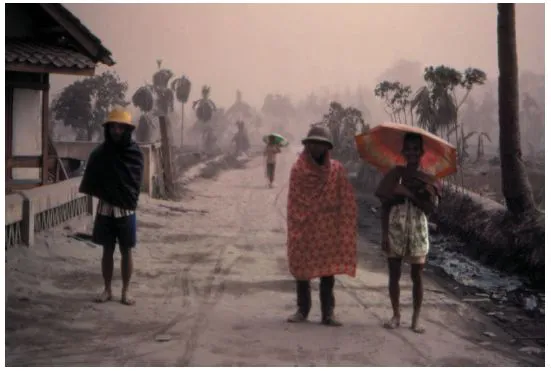
Fine ash was falling in a dim light that afternoon in July 1982, limiting visibility to about a hundred meters outside the Volcanological Survey of Indonesia (VSI) Cikasasah Emergency Observation Post. Light grey ash covered everything in sight and could have been mistaken for snow, were it not for the broken coconut palms and the sweltering tropical heat. The narrow road in front of the VSI Observation Post was clogged with fleeing refugees who, with heads covered with newspapers or plastic bags and faces covered with cloth breathing filters, carried their bundles and baskets quickly down the road (Fig. 1.1). Children carried babies and led water buffalo. An occasional small flatbed truck, almost obscured by its overflowing human cargo, crawled along with the refugees.
The fresh-fallen ash muffled the sounds of footsteps, and the people were silent as they hurried down the road away from danger. The only constant sounds were Muslim prayers, wailed in Arabic over a loudspeaker at a refugee camp on a high, relatively safe ridge 1 km away. Thunder and the dull booming of explosions from the direction of Galunggung’s crater 7 km away became louder and more frequent while ash fell more heavily, so I (JPL) turned to go back inside the observation post.
Inside the post, a beehive atmosphere prevailed as technicians busily checked seismographs and shouted out readings to communications specialists in an adjoining room. Their reports were being radioed to Civil Defense Headquarters in the city of Tasikmalaya, 17 km away (Fig. 1.2) and to the VSI Headquarters in Bandung, 75 km to the west: Tremor vulkanik mulai naik – amplitud duabelas millimeter sekarang – kami mendengar letusan-letusan dari kawah! (“Volcanic tremor is beginning to increase – the amplitude is now 12 mm – we hear explosions from the crater!”) The observation post was set up in a well-built house in the evacuated zone, but extremely fine volcanic dust nonetheless managed to infiltrate cracks and was everywhere. Note-taking was difficult since fine ash continuously settled on the paper and clogged our pens. The dust formed golden halos around the naked light bulbs dangling from the ceiling, and observers all wore cloth masks over their faces to facilitate breathing. We were in the dangerous Red Zone, as close to Galunggung’s central crater as possible, where no one but emergency personnel were allowed to stay at night, and the thought nibbled at the edge of my consciousness – “Do I really want to be here?” That thought never progressed very far, however, since I knew that at that moment I was one of the most fortunate volcanologists anywhere. Reading about volcanoes is fine, but being at a volcano, especially during an eruption, is the best means to discover new knowledge. I suspected that the next three months at Galunggung were going to include some of the most concentrated learning experiences of my life.
Fig. 1.1 Refugees from falling ash at midday, outside the Galunggung Volcano Observatory, Cikasasah, Indonesia, August, 1982. USGS photo by J. P. Lockwood.
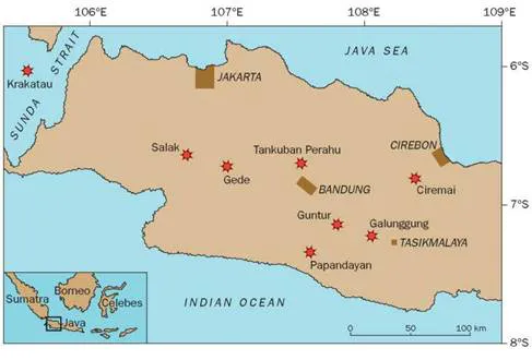
Fig. 1.2 Location of Galunggung and other major active volcanoes (starred circles) of central Java, Indonesia. Major metropolitan centers (bars) are also indicated.
Galunggung is at the center of the most fertile, heavily populated agricultural land in central Java. It is a horseshoe-shaped volcano, whose central portions had been blown out by a catastrophic prehistoric eruption (Fig. 1.3). For many kilometers to the east, the plain is littered with thousands of small hills, each representing a shattered fragment of the volcano’s heart. Hardworking farmers had established a productive complex of rice terraces and fish ponds inside Galunggung’s amphitheater, an area that was renowned in all Java for its beauty and agricultural efficiency. All was quiet during the early months of 1982, and there had been no activity at the volcano since the formation of a large dome during a small non-explosive eruption within the central crater in 1918. The VSI monitors the volcano on an annual basis, but the previous “check-up” in 1981 had shown nothing anomalous. Galunggung’s potential danger was well-known to local authorities, however, as about 4000 people had been killed downstream of the volcano by hot lahars (mudflows) in 1822. Legends of devastating prior eruptions abound in the records of the local Tasikmalaya Sultanate.
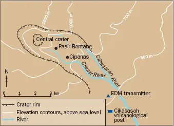
Fig. 1.3 Galunggung volcano, Indonesia. Terrain features and locations of geodetic survey stations during the 1982–3 eruption.
Residents did not need to be told what to do when a sharp earthquake was felt by Galunggung farmers on the evening of April 4 and snakes reportedly began to emerge from the ground. Those living within and near the central crater around the volcanic dome that had grown there in 1918 quickly began to evacuate. Earthquakes continued that night, and a violent eruption tore apart the center of the crater the next morning. Because the people had fled during the night, no one was killed, though many homes were destroyed. The VSI was alerted, and the first team of volcanologists arrived on April 6. Their portable seismometers showed high levels of earthquake activity, and they recommended an immediate evacuation of all people within the Galunggung “horseshoe.” Their warning came none too soon, as a powerful explosion on the evening of April 8 devastated a wider area up to 4 km from the crater and generated highly fluid, incandescent pyroclastic flows which poured about 5 km down the Cibanjaran River, incinerating several small villages. Again, because the people had been warned, there were no casualties. Eventually more than 100,000 residents left their homes for “temporary” refugee camps which had been hurriedly constructed just outside the danger area.
The Galunggung activity continued to increase in violence over the next several months. Explosive eruptions repeatedly sent churning clouds of ash and steam more than 16 km into the sky. Galunggung’s activity was noted on international news wires on June 24 when a British Airways 747 with 250 people aboard entered an ash cloud over central Java during an explosive night eruption of the volcano. The jet was flying between Singapore and Perth at 11,300 m when it entered the ash cloud and abruptly lost power in all four engines. After gliding free of the ash, the pilot was able to restart three engines and barely make it back to Jakarta airport for a “blind” emergency landing (the windshields had been frosted by ash abrasion).
These ash clouds deposited their loads over a wide area, and ash fell as far as Jakarta, 190 km away. About 25 million people were affected by “nuisance” ash, which required repeated cleanup. More than 500 million cubic meters of ash eventually blanketed much of west Java. An area of about 10,000 km2 was covered by ash at least one centimeter deep which clogged irrigation systems, damaged crops, and seriously lowered food production in the heart of central Java’s rich farmland. At one point, a half-million people faced serious food shortages that required expensive relief efforts by the Indonesian government.
I (JPL) first learned about the Galunggung eruption in early April, when John Dvorak called the US Geological Survey’s (USGS) Hawaiian Volcano Observatory (HVO), after having seen the first explosion from the summit of Merapi volcano, 290 km to the east. John was in Indonesia as a participant in a cooperative program between the USGS and the VSI, supported by the US Agency for International Development (USAID). This program was designed to introduce the VSI to modern volcano monitoring techniques in use at HVO. I was slated for a four-month assignment to Indonesia that summer, and spent the remainder of the spring at HVO preparing equipment for the trip.
My family and I left for Indonesia in July, burdened by an incredible load of tripods and other survey gear. While enroute, we read that yet another jet had been forced down after an encounter with a Galunggung ash cloud. We knew nothing of the seriousness of that episode, however, but were amazed on our flight between Singapore and Jakarta when I looked outside and counted three engines on the starboard wing! The pilot was walking down the isle at the time and I asked him what sort of strange airplane this must be with six engines. “No, there are only five,” he said, “the extra one on the starboard wing is being carried to Jakarta to replace one of the damaged engines on the plane downed by Galunggung.”
At the Jakarta airport, we could see the Singapore Airlines 747 parked off to one side with its badly sandblasted windshield and paint. The circumstances were similar to those of the earlier British Airways incident: The plane had flown into an ash cloud at 10,000 m and had lost power in three of its four engines. The disabled jetliner with its 230 terrified passengers had descended to 4000 m before the pilot was able to restore partial power to two engines and limp to Jakarta airport. Examination of the engines later revealed that the Galunggung ash had melted within each and had been deposited as glass on the turbine blades. After this second near-disaster, commercial aircraft re-routed their flights far from Galunggung for the duration of the eruption, and the aviation industry, in close cooperation with volcanologists, began major efforts to educate pilots about volcanic ash hazards (Chapter 14).
Upon our arrival at the VSI headquarters in Bandung, I was told by Dr Adjat Sudradjat, the VSI Director, that because of the mounting economic and social impact of the continuing Galunggung eruption, he would prefer that I not work primarily at Merapi as previously planned, but instead prepare to spend most of my time at Galunggung. I was delighted, and traveled to Galunggung that night.
Two critical questions urgently required answers from the volcanologists at Galunggung: i) When would the eruption stop? (critical information, which would dictate how long Government relief efforts would be required); and ii) Was there any chance that a much larger eruption might occur, and if so, was the evacuated zone large enough – was the city of Tasikmalaya safe? The 1883 eruptions of Krakatau [98] had killed more than 30,000 people in Java, and memories of that tragedy had not been forgotten.
Electronic Distance Measurement (EDM) instruments were some of the most important tools available to us for answering these questions. John Dvorak and his Indonesian colleagues had established a small EDM network in mid-May, and had set up laser reflectors close to the crater. However, those were destroyed by a violent eruption a few hours after the field party had left the area. Because of continuing eruptive activity, no one was able to visit the crater area for the next few months. The major eruptions occurred every few days, and were incredibly spectacular at night (Fig. 1.4). The continuing eruption was causing major economic impact on Indonesia, however, and there was no way to enjoy the fireworks. The eruption had already devastated a large area of fertile farmland near the volcano, more than 50,000 residents had been evacuated to refugee camps, and the lives of millions of people were being disrupted by widespread ash across central Java. By late July, it was apparent that a larger EDM network, including stations closer to the central crater, was critically needed. This would allow us to estimate the size of the magma reservoir beneath the volcano and thus assess the danger of larger eruptions, as well as to better predict individual eruptive phases. We somehow had to establish new stations closer to the crater.
Fig. 1.4 Night view of Galunggung volcano in eruption, September, 1982. This two second exposure indicates the continuous lightning activity associated with the eruption of electrostatically charged ash. USGS photo by J. P. Lockwood.
Our EDM equipment consisted of a laser transmitter and special reflectors. The transmitter (or “gun”) was set up at one survey point (Fig. 1.5) and the reflectors at another; the precise distance between gun and reflector can then be measured to the accuracy of a few millimeters by computerized comparison of the light signals leaving the gun and the returned light from the reflectors. To establish reflector stations closer to the crater, we had to figure a “safe” time to approach closer. Small explosions were nearly continuous at the crater but the violently explosive, more dangerous eruptions were occurring at intervals of one to seven days. We soon noticed that these larger eruptions were all preceded by a brief period of eruptive quiet, followed by 2–3 hours of gradually increasing activity building up to the most violent explosions. Thus, it looked as if a volcanological team would have time to make a quick visit to the outer rim of the central crater and install EDM reflectors during the pre-eruptive “quiet” p...