
- English
- ePUB (mobile friendly)
- Available on iOS & Android
eBook - ePub
Sustainable Development in the USA
About this book
After WWII, the United States of America proposed their way of life, based on an unlimited consumption of land, goods, and energy, as a model for the entire world. Nowadays, this expansionist model has reached its limits. This book provides a comprehensive study of the geographical basis of the American settlements, assuming that part of the U.S. overshooting is related to geography because of harsh climates and the continental size of the Nation, but another part is the result of a cultural habits of expansion and segregation. Urban Sprawl, for instance, is the real Achille's heel of America, because it challenges the cultural revolution required by sustainability. From the continental physiography to the New Orleans – Katrina case, this book explores these issues with maps and charts created with the help of a nationwide multiscalar GIS.
Trusted by 375,005 students
Access to over 1.5 million titles for a fair monthly price.
Study more efficiently using our study tools.
Information
Chapter 1
The American Territory
1.1. A continent-nation with a dispersed population
The United States of America consists of a federation of 50 states located on the North American continent and in the Pacific Ocean. The country’s surface area spans 9,161,924 km2, and represents 6.1% of the total of Œkoumene.1 It is the fourth largest country in the world after Russia, Canada, and China (see Figure 0.1).
Although it has the third largest population in the world after India and China, its population only represents 4.5% of the world’s total population.
With nearly 32.4 inhabitants/km2, the US has a lower population density than the world average of 50 inhabitants/km2 according to the latest population estimates of the United Nations. The US territory is composed of three distinct geographical areas. The vast boreal region located in the northwest became the 49th state of the Union in 1959. The state of Alaska spans 1,481,347 km2, but its estimated population of 663,661 in 2005 gives it an average density of only 0.45 inhabitants/km2.
After long benefiting from the status of “colony”, the Pacific archipelago of the Hawaiian Islands had a population of 1,275,194 inhabitants in 2005, a surface area of 16,635 km2, and an average population density of about 76.7 inhabitants/km2. Hawaii became the 50th state of the Union in 1959.
Most geographical studies of the United States focus on the territory of the 48 conterminous states, including the District of Columbia, and the two remaining states are treated separately. The surface area of the conterminous states is 7,663,942 km2. With an estimated population of 294,471,549 inhabitants in 2005, the average density (38.4 inhabitants/km2) remains below the world average.
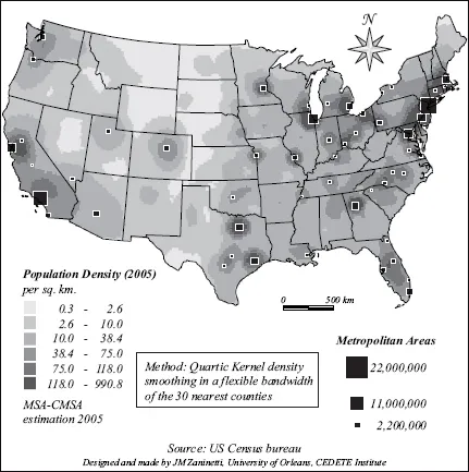
The population is very unevenly distributed (see Figure 1.1). The permanent imbalance between East and West can first be explained by the history of the country, but many other elements are explained as a matter of location and environment.
Geographical determinism is particularly important for the two peripheral states in the Pacific region.
Alaska is largely unoccupied, due both to its location and to its environment. It is a remote, peripheral territory, located in the extreme northwest of the continent on the opposite side of the territory from the area first settled by Europeans. It is also a boreal region with a very hostile climate; it is mostly barren, very mountainous (Mount McKinley, 6,194 m), volcanic, and highly prone to seismic activity. Access is very difficult; only the southern coast is free of ice all year round. As the “last frontier” for American pioneers, Alaska is nonetheless a highly coveted territory due to its wealth of natural resources, particularly hydrocarbons.
The Hawaiian Islands benefit from a tropical climate with relatively favorable trade winds since they are outside the path of major hurricanes in the Pacific. They are, however, a mountainous region of volcanic origin with highly active, though not eruptive, volcanoes. Populated areas are therefore concentrated along the coast. Freshwater resources in volcanic regions are typically scarce, particularly on the leeward coast.
It is also an ultra-peripheral region which lived in total isolation until the 19th century. Its intermediary position between America and Asia earned strategic interest during the imperial period of 1895–1945, which led to a mixed population of indigenous Polynesians, American settlers of European origin, and immigrants from Asia, particularly Japan.
With the arrival of long-distance aviation, its strategic importance declined, but the archipelago developed a solid tourism-based economy to the point where the Oahu island coast is, in fact, densely urbanized today. Today, over 72% of the archipelago’s population resides in the metropolitan area of Honolulu.
Geographical determinism also influences the 48 conterminous states. It is easier to understand the geography of the population through a map of counties2 as opposed to a map of states, but not without first adjusting values to smooth the effects of variability, improve the map’s general readability, and compensate for the fact that the very large counties of the West are much more visible than those of the East.
As with most maps that show detailed socioeconomic data, the following map was realized using this smoothing process [ZAN 05].
Figure 1.1. Population density 2005
From the Atlantic to the Pacific, the country has very simple, yet strikingly vast, structural areas. The territory forms a rectangular block of 7.7 million km2 which lies between 67°W and 125°W longitude and spans 4 time zones. New York is barely closer to San Francisco than it is to Ireland. From east to west, the 45th parallel crosses the country over nearly 4,500 km. In latitude, the country stretches from the 24th parallel North at the tip of Florida, to just a stone’s throw from the 49th parallel North, which was adopted under a treaty with England in 1846 as the official border between the United States and Canada, west of the Mississippi all the way to the Pacific coast. From north to south the 100th meridian crosses the country for more than 2,500 km between Mexico and Canada. With its continental mass and its position in latitude, the United States territory is quite similar to the territory of China, with one major difference: it shares borders with the ocean on three sides along nearly 40,000 km of its coastline. This long coastal played a considerable role in the settlement of the United States.
Figure 1.2. Population share living within 100 km of an ocean or the Great Lakes
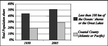
The Atlantic Ocean coast is the longest, with nearly 23,500 km, and follows a very jagged coastline from the tip of Florida to Maine, and 2,600 km in a straight line from Key West to the Canadian border. The Atlantic Ocean extends south and merges with the vast Gulf of Mexico. Less uneven than the Atlantic coast, the Gulf Coast is more than 8,300 km in length. Over 18,100 km long, the Pacific coastline stretches over 1,900 km in a straight line between San Diego and Vancouver. In addition to these three ocean fronts, the five freshwater Great Lakes at the Canadian border form a veritable inland sea stretching over nearly 250,000 km2, and greatly influencing the climate of the Northeast. The majority of the US population now resides in a “coastal region”, defined by the National Oceanic and Atmospheric Administration (NOAA) as a place usually located within 100 km of one of the three ocean fronts or the Great Lakes (see Figure 1.2). In 2005, the average population density of these coastal regions reached 118 inhabitants/km2, compared to only 22 inhabitants/km2 for the “inland” regions in the conterminous 48 states. Although not a new phenomenon, the importance of “coastal” regions has increased since 1930. While total population grew by 140% between 1930 and 2005, that of coastal regions increased by 176%, and that of inland areas by 114%. If we exclude the Great Lakes and only consider counties located along the coasts of the Atlantic, Gulf of Mexico or Pacific, the coastal population, as defined in its most traditional sense, increased from 24 million in 1930 to nearly 84.5 million in 2005, representing an increase of 250%, and a density of 165 inhabitants/km2.
The first seven chapters of this book are devoted to identifying the factors which explain today’s map of the population, and to exploring the diversity of these factors.
1.2. Major geographical areas
Figure 1.3. Topography of the United States of America
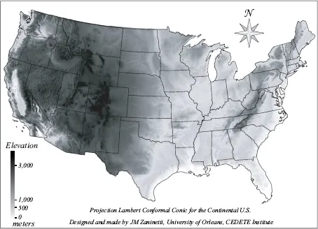
Land topography has as much influence on settlement as do climate and the presence of waterways. Topography influenced settlement patterns from the very beginnings of westward expansion, as well as the development of regions by populations of European origin. Site characteristics defined the location of major cities founded in the eighteenth and nineteenth centuries, less because of obstacles brought about by nature, and more because of the natural influence that the environment had on transportation conditions at a time when horse-drawn carts and inland waterways still represented the main means of transportation, and the first railways were struggling to climb steep slopes. The urban framework developed naturally, starting on the Atlantic coast and gradually expanding westward, based on opportunities determined in part by topography. Rural populations were more influenced by the obstacles of nature, mostly climate-based, but they were also strongly influenced by topography and altitude.
A land relief map shows three main regions running north to south (see Figure 1.3). To the east, the medium-size Appalachian Mountains reach 2,060 meters. They separate the coastal plains of the Atlantic, which are narrow in the north and wider in the south and end with the very flat peninsula of Florida, from the central Great Plains. Even though the Appalachians hardly represent a real obstacle to settlement, they played a role in the layout of transportation routes which prevailed before 1850. The development of some transportation and urbanization networks was influenced by the ease of movement offered by valleys. The development of New York, and its dominance over its rivals, Boston, Philadelphia and Baltimore, at a time when coastal cities (gateways to Europe) were supplying westbound settlers and therefore driving the country’s expansion was greatly assisted by its easy access to the Hudson-Mohawk passage. These same transportation factors facilitated to a lesser extent the development of the city of Pittsburgh, Pennsylvania, situated at the head of the Ohio River Valley.
The Great Plains form the largest geographical natural region on the continent, and extending into Canada. In the US portion they form a flat basin which is drained by the third largest river basin in the world, that of the Mississippi River and its major tributaries. From the source of the Missouri River all the way to the Mississippi River delta, the Missouri-Mississippi river system extends to 5,934 km. The drainage basin covers 3.22 million km2. The deep gutter that follows along the 2,000 km of the Mississippi’s lower course corresponds with a tectonic trench of high seismic risk (New Madrid fault). Towards the south, the Lowlands cover the entire coast of the Gulf of Mexico, with its uneven shores, especially in the vast delta of the Mississippi. In the north, the dividing line between the Mississippi and St Lawrence River basins does not show any significant land relief, but it represents the limits of the terminal moraine from the last Quaternary glaciation.
It was only in the vast plains of the Middle West that the US was really able to put into practice the geometric survey of the territory based on the parallels and meridians of Thomas Jefferson’s concept of Township.3 The geometric grid, which characterizes urban and rural areas, and was initiated in Philadelphia in the eighteenth century, is a hallmark of the American landscape. In these immense flat areas, it is the hydrographic system that determines the points of contact between land and river transport, or the crossing points of major rivers where main cities were built. The success of Chicago is therefore linked to its location at the southern tip of Lake Michigan.
The eastern part of the territory is populated in a continuous and relatively dense manner. This is first explained by the precedence of its colonization, but also by the absence of any major natural obstacles.
West of the Mississippi, the environment becomes less friendly, especially starting at the 100th meridian. The Great Plains rise gradually until they form the foothills of the Rocky Mountains. The city of Denver is more than 1,600 meters above sea level. These high plains differ from the lower plains of the Middle West mostly by their semi-arid climate. The plains end abruptly at the barrier of the Rocky Mountains. The Rocky Mountains are actually a series of separate mountain ranges whose altitude do not exceed 4,400 meters. They mark the beginning of the Pacific West region, whose topography is particularly rugged all the way to the coast.
The irregular geology of fault blocks explains the juxtaposition of mountain chains and basins, some of which form high plateaus and others very deep troughs. This is why, for instance, the Great Salt Lake of Utah is situated at an altitude of 1,280 meters.
The highest point of the conterminous United States is Mount Whitney (4,417 m) located in the Sierra Nevada in southern California, just 150 km away from the lowest point located in Death Valley at 86m below sea level.
This irregular topography considerably impeded the progress of settlers in the 19th century. High altitudes combined with the land’s general aridity explain the very sparse population of the plateaus and basins of the inland regions of the West. Apart from a few urban oases, the population of the West is concentrated along the shores of the Pacific Ocean.
Figure 1.4. Areas of volcanic and seismic risk
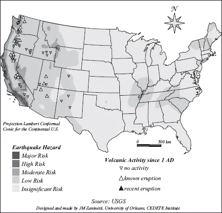
Of all the natural haz...
Table of contents
- Cover
- Title Page
- Copyright
- Introduction
- Chapter 1: The American Territory
- Chapter 2: Developing the Territory
- Chapter 3: A Rapidly Growing Population
- Chapter 4: A Multi-ethnic Nation
- Chapter 5: Regional Dynamics
- Chapter 6: Economic Change and Territories
- Chapter 7: A Suburban Nation
- Chapter 8: Urban Fragmentation and Sprawl
- Chapter 9: New Orleans in Dangerous Waters
- Conclusion: About the Ecological Footprint of the United States and of Sustainable Development in General
- Glossary
- References
- List of Tables and Figures
- Index
Frequently asked questions
Yes, you can cancel anytime from the Subscription tab in your account settings on the Perlego website. Your subscription will stay active until the end of your current billing period. Learn how to cancel your subscription
No, books cannot be downloaded as external files, such as PDFs, for use outside of Perlego. However, you can download books within the Perlego app for offline reading on mobile or tablet. Learn how to download books offline
Perlego offers two plans: Essential and Complete
- Essential is ideal for learners and professionals who enjoy exploring a wide range of subjects. Access the Essential Library with 800,000+ trusted titles and best-sellers across business, personal growth, and the humanities. Includes unlimited reading time and Standard Read Aloud voice.
- Complete: Perfect for advanced learners and researchers needing full, unrestricted access. Unlock 1.5M+ books across hundreds of subjects, including academic and specialized titles. The Complete Plan also includes advanced features like Premium Read Aloud and Research Assistant.
We are an online textbook subscription service, where you can get access to an entire online library for less than the price of a single book per month. With over 1.5 million books across 990+ topics, we’ve got you covered! Learn about our mission
Look out for the read-aloud symbol on your next book to see if you can listen to it. The read-aloud tool reads text aloud for you, highlighting the text as it is being read. You can pause it, speed it up and slow it down. Learn more about Read Aloud
Yes! You can use the Perlego app on both iOS and Android devices to read anytime, anywhere — even offline. Perfect for commutes or when you’re on the go.
Please note we cannot support devices running on iOS 13 and Android 7 or earlier. Learn more about using the app
Please note we cannot support devices running on iOS 13 and Android 7 or earlier. Learn more about using the app
Yes, you can access Sustainable Development in the USA by Jean-Marc Zaninetti in PDF and/or ePUB format, as well as other popular books in Social Sciences & Regional Studies. We have over 1.5 million books available in our catalogue for you to explore.