![]()
Chapter 1
The physical template
CHAPTER CONTENTS
Introduction
Marine regions
Salinity and mineral content
Depth, pressure, and topography
Light and irradiance
Temperature
Oxygen
Tides
Waves
Ocean currents
Vertical currents and the global conveyer belt
Local currents
Suspended sediments
Climate change
Conclusions
Introduction
The physical environment determines the most fundamental constraints acting upon life. Life is only possible over a small part of the potential range of physical variables such as temperature that may occur on Earth and all species have evolved adaptations optimized for particular conditions. However, the physical conditions on Earth which all life, including man, are constrained by are not purely the result of physical processes. Life on our planet, and particularly life in the oceans, modifies the physical environment and makes the planet more suitable for life. The physical template we observe is to some extent the product of organisms over millions of years. Since life began in the oceans about 3.5 billion years ago, factors such as salinity, temperature, oxygen and nutrient levels have been shaping the evolution of the myriad of marine organisms alive today and they have in turn been changing these and other variables. Before we examine in detail these organisms and their interactions, it is appropriate to consider the major physical processes acting within the oceans that form the template upon which every ecological community is built.
Marine regions
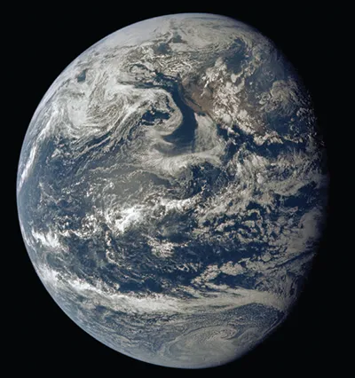
The sea covers 70% of the surface of the earth and offers greater than 98% of the total space available to life. The Earth from space (Figure 1.1) is clearly a water world; observers approaching from a distance would likely assume all dominant life is marine, simply from the color of the distant planet. Indeed, the preponderance of terrestrial species is a geologically recent phenomenon. Further most of the habitat is in deep water; only about 3% of the world’s waters lie over the continental shelf, which have an average depth of around 200 m. The average depth of the oceans is 3200 m and the maximum depth of about 11,200 m is at the bottom of the Challenger Deep in the Marianas Trench near Guam in the western Pacific.
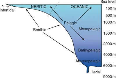
As shown in Figure 1.2, working from the land towards increasing depth, a number of major habitat divisions are recognized. The zone that is influenced by the sea but not always covered in water is the intertidal, or littoral. Next, the sublittoral extends from the extreme low water level down to about 40 m, which is around the safe limit for recreational scuba diving on compressed air. From the edge of the continental shelf the depth increases down the continental slope then slopes more gently down the continental rise to reach the abyssal zone. The continental shelf is the submerged gently sloping border of the land, the width of which varies from 100 m to 1300 km. The continental slope marks the edge of the continents and the region where the seabed slopes at an average angle of 4 degrees to a depth of about 2000 m. The foot of the slope marks the beginning of the abyssal plain.
Figure 1.1 Earth from space. Planet Earth taken by Apollo 11, July 16, 1969. (Photograph courtesy of NASA.)
Figure 1.2 Diagram showing location of major marine habitats in relation to depth.
Aquatic habitats are classified by depth and locality within the water body. The term benthic is used to describe living on or within the seabed at any depth. In comparison, the neritic zone extends from the low-tide level to a depth of 200 m, and is thus at or near coastlines in contrast to the oceanic zone which occurs away from land. Pelagic is used to describe the open water habitats, which may lie close to shore and they can also be described as neritic. Pelagic habitats are divided into four depth zones, epipelagic (0–200 m), mesopelagic (200–1000 m), bathypelagic (1000–4000 m), and abyssopelagic (below 4000 m). The term hadal is used for the deepest parts of the oceans below 6000 m in depth.
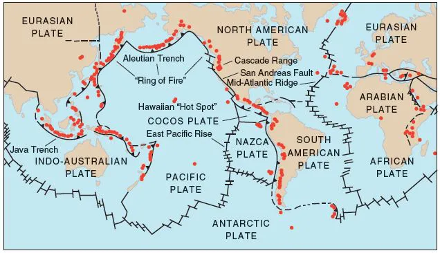
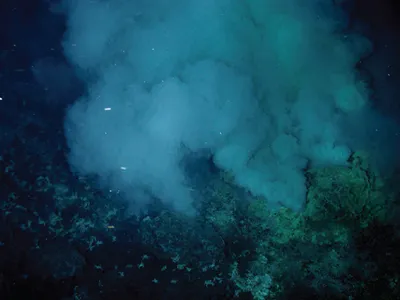
The ocean floor is not featureless and the boundaries of the tectonic plates (Figure 1.3) are marked by towering underwater mountain ranges. Figure 1.3 shows the Mid-Atlantic Ridge running down the centre of the Atlantic Ocean, roughly parallel to the shores of Africa and Europe to the east, and the Americas to the west. Similarly, in the Pacific Ocean, approximately 3000 km off the South American coast, there is the East Pacific Rise. This oceanic ridge towers about 2 km from the ocean floor, and stretches from the Gulf of California to the southernmost tip of South America. Submarine ridges owe their formation to the movement of the continental (tectonic) plates. As these plates slowly move away from each other, they leave gaps in the Earth’s crust. This allows molten rock from beneath the Earth’s crust to move up into the gap, forming a new ocean floor. As the molten rock seeping through these gaps is under pressure, it spews upward, forming a ridge. These ridges cause oceans and seas to be divided into basins. It is in these gaps that hydrothermal vents occur (Figure 1.4), where seawater is superheated by the volcanic activity and discharged in black or white “smokers.” This water is rich in dissolved sulfur, iron, and other minerals, and such sites may have supported the first appearance of life on earth.
Mid-ocean ridges are regions of high volcanic activity and are estimated to produce 75% of the total annual output of molten volcanic rock, magma, on earth. It has been estimated that there are more than one million submarine volcanoes and perhaps as many as 75,000 of these volcanoes rise over 1 km above the ocean floor. Some break the surface to form isolated volcanic islands. The Galapagos archipelago in the Pacific Ocean off the coast of South America is a well-known example of a volcanic island group. Ocean trenches are also linked to the boundaries of tectonic plates and are formed as two plates collide and one moves under the other.
Salinity and mineral content
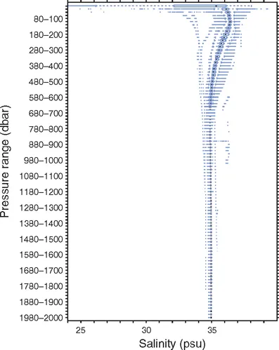
Ocean water has an average salinity of 34.72 parts per thousand (ppt) (or 3.472%) of sodium chloride (NaCl), normally approximated to 35 ppt. This reduces in coastal waters, for example, inshore British or East Coast American Atlantic waters have a salinity around 33–34 ppt. Mixtures of salt and freshwater are termed brackish when the salinity ranges between 8 and 33 ppt and fresh below 8 ppt. In seas where surface evaporation is not balanced by freshwater inputs, salinity can be higher than the average. The Mediterranean Sea has a surface salinity of about 38–39 ppt. Surface water salinity varies across the globe and is, on average, lowest towards the North Pole, probably associated with melting icecaps, and highest in more tropical latitudes where surface evaporation is greatest (though not necessarily exactly at the Equator due to ocean circulation patterns). Salinity also varies somewhat with depth and lower salinity water is less dense and will lie over higher salinity water of the same temperature. But as can be seen from Figure 1.5, as depth increases, in this case measured by water pressure measured in dbar or decibars (2000 dbar = 200 bar = 197 atmospheres = 2040 m H2O), salinity in the open sea (in this example in the Gulf of Mexico) stays fairly constant at just under 35 ppt (Thacker 2007).
Figure 1.3 The boundaries of the tectonic plates showing the areas of greatest geological activity. (Reproduced with permission of Cascades Volcano Observatory, US Geological Survey.)
Figure 1.4 Hydrothermal venting from sulphur mounds. (Photo courtesy of Submarine Ring of Fire 2006 Exploration, NOAA Vents Program.)
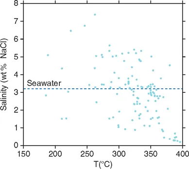
As we shall see later in this chapter, temperature and depth are linked, so that deeper water tends to be colder than surface water at least in temperate and tropical seas, though close to deep-sea hydrothermal vents where volcanic activity just beneath the seabed produces superheated seawater from cracks in the Earth’s crust, the temperatures can become extremely high. As temperatures reach upwards of 350°C, salinities may drop to less than 10 ppt (1‰ Figure 1.6, Fontaine et al 2007). Maximum salinities of water leaving vents such as black smokers are limited as a result of phase separation, where seawater which enters a vent system becomes separated into a low-salinity vapour phase, which rapidly rises and pours out through the vent chimneys, and a highly saline brine phase, which stays pooled within the vent system and is only released slowly.
Figure 1.5 Box and whisker plots of salinity within 20 dbar pressure intervals. Data collected from the Gult of Mexico. (From Thacker 2007; reproduced with permission of Elsevier.)
The mineral content of seawater is not a simple solution of sodium chloride, but is dominated by 11 chemicals which in order of concentration are chloride, sodium, sulphate, magnesium, calcium, potassium, bicarbonate, bromide, strontium, boron, and fluoride. In addition, there is a large number of trace elements that are listed in Table 1.1. Many of these trace components have important biological functions. For example, calcium is of course a vital building block for exoskeletons, potassium an important fertilizer for marine primary productions, whilst boron is a trace element used for cellular processes by plants such as seagrass. We shall revisit some of these actions in later chapters.
Figure 1.6 The salinity and temperature relationship for high temperature vents. (From Fontaine et al 2007; reproduced with permission of Elsevier.)
Table 1.1 Detailed composition of seawater at 35 ppt salinity in order of abundance (based on values given by Turekian (1968) Oceans, published by Pr...