This book explores how mountainous landscapes respond to tectonic deformation. It integrates previously unpublished concepts and ideas with recent articles about hills and streams. Readers will learn which landforms change quickly in response to uplift, which parts of the landscape are slowest to adjust to tectonic perturbations, and which landform characteristics are most useful for describing tectonically active and inactive terrains.
Study areas include diverse landscapes and tectonic settings: seacoasts, soil-mantled hills, and lofty mountains. The humid Southern Alps of New Zealand change quickly because of rapid uplift and erosion. The semiarid Panamint Range of southeastern California has such miniscule annual stream power that tectonic landforms persist for millions of years.
Tectonically Active Landscapes addresses diverse key topics about tectonics and topography. It is essential reading for research geologists and advance-level undergraduate and graduate students in the earth sciences.
Trusted by 375,005 students
Access to over 1.5 million titles for a fair monthly price.
This tectonically active landscape is rising out of the sea on the transpressional boundary between the Pacific and Australian plates. The landforms reflect three basic controls on landscape evolution – lithology, climate, and rock uplift.
The long pair of parallel ridges of the Eocene Amuri Formation is an erosionally truncated syncline in the Puhi Puhi valley of New Zealand. The limestone rock mass strength is higher than the fractured sandstone in the middleground, so differential erosion has made the syncline higher in the landscape.
Folding and thrust faulting here have resulted in ~10 km of local crustal shortening (Crampton et al., 2003). Uplift rates increase abruptly from 1 to 6 m/ky across the Jordan thrust fault in the foreground. They also appear to increase towards the left side of the view; note the parallism of the limestone ridges and the skylined ridgecrest underlain by fractured sandstone.
Steep braided rivers at the lower-right edge of this view reflect rapid erosion of the fractured greywacke sandstone of the Torlesse Formation underlying the 2,500 m high Seaward Kaikoura Range. Flat grassy ridgecrests in the broad valley are stream terraces that record tectonic and climatic controls on this rapidly changing landscape. Late Quaternary climatic changes caused pulses of aggradation that briefly raised valley floors. Long-term tectonically induced downcutting has preserved previous valley floors as the steps and risers in flights of stream terraces.
The format of this book is to explore wide-ranging, important, topics in tectonic geomorphology. I mainly use the exceptionally diverse landscapes and tectonic settings of southwestern North America. Lengthy discussions presented in Chapters 2, 6, and 7 use sites in tectonically young New Zealand and Greece, and in the Himalayas where time spans of tectonic deformation are much longer. United States mountainous landscapes investigated in Chapters 2 through 8 are influenced by regional tectonic shifts of the adjacent Pacific and North American plates. So, this diverse tectonic setting is summarized first.
Chapter 1 summarizes regional tectonic settings. This format underscores the interlinked nature of recent tectonic activity of southwestern North America in one place. Tectonic settings of this region include the Basin and Range Province, Walker Lane–Eastern California shear zone, Sierra Nevada microplate, Diablo Range adjacent to the San Andreas fault, and the migrating Mendocino triple junction. Chapters 2–4 study hillslope processes and responses to tectonic base-level fall of adjacent streams. Chapters 5–8 are a series of essays that explore steady-state premises, consider how erosion influences fracturing and faulting, examines drainage-net responses to propagation of fault tips, and discuss how upwelling asthenosphere affects geomorphic processes.
1.1 Introduction
Rising mountains are different than tectonically inactive landscapes. Just being high and lofty may not tell us if mountain-building forces are still active. Instead, we should scrutinize landforms and the geomorphic processes that create them. Streams deepen their valleys in response to increases of watershed relief, and this changes the length, slope, and curvature of the adjacent hills.
Uplift may be regional and isostatic, but often is concentrated on range-bounding faults and folds. Such local tectonic deformation may be regarded as a perturbation (change in a variable of fluvial systems) that steepens stream gradients in the mountain-front reach. The effects of such tectonic displacements emanate from the range-bounding fault. Long time spans may pass before the consequences of renewed uplift arrive at distant upstream reaches of the drainage basin. Streams are the essential connecting link between different sections of a drainage basin. Tectonically induced downcutting along a trunk stream channel steepens the footslopes of the adjacent hillsides and increases hillslope area too. Notable results include increases of stream power and hillslope sediment yield. Concurrent changes in climate also alter types and rates of geomorphic processes.
Changes in climate and rock uplift operate separately – they are independent variables – to alter geomorphic processes and landscape characteristics. Both variables originate outside of the drainage basins that comprise mountainous landscapes.
Response times for Late Quaternary climate-change perturbations are much shorter than those for mountain-front uplift. Climate change impacts all of a watershed with minimal time lag. The resulting changes in the size and amount of stream-channel bedload influence rates of tectonically induced downcutting. Climate-change induced impacts on geomorphic processes, such as changing valley-floor deposition to erosion, are pervasive. An aggradation event temporarily overwhelms the influence of concurrent tectonic displacements for a reach of a stream tending to maintain steady state valley-floor erosion (unchanging longitudinal profile underlain by a strath).
A good example is the Charwell River basin in the South Island of New Zealand. Repeated surface ruptures on a range-bounding fault created a 40 m high sub-alluvial fault scarp during a climatechange-induced aggradation event. Aggradation disrupted the continuity of an erosional fluvial system and prevented the tectonic perturbation from migrating upstream. The mountain range was raised 42 m between 26 and 9 ka1, but climatic controls delayed the upstream transmission of the tectonic perturbation for 17 ky. Sediment flux modeling (Gasparini et al., 2007) illustrates the strength of climatic controls on bedrock incision rates. “Geomorphic Responses to Climatic Change” (Bull, 1991) elucidates the effects of Late Quaternary climatic and tectonic perturbations in mountain ranges whose present climates range from extremely arid to extremely humid.
We have much to learn about the possible impacts associated with the present acceleration of human-induced global climate changes. Geomorphic impacts may resemble the consequences of the Late Quaternary climate changes, but the types, rates, and magnitudes of change in geomorphic processes could be quite different.
Both the Pleistocene and Holocene styles of climate change are now history, having been replaced by the Anthropocene (Crutzen and Stoermer, 2000). Intensification of human activities with the onset of the industrial revolution now influences the climate of planet Earth. Amounts of temperature change seem modest, but rates of change are more than an order of magnitude faster than during the Quaternary. Models based on slowly changing Quaternary climates may not be appropriate now.
We could be entering significantly new territory with local demise of permafrost (Cheng and Wu, 2007; Gruber and Haeberli, 2007), and eradication of so much tropical rain forest (Aitken and Leigh, 1992). But human impacts on forests are not a recent development (Bjorse and Bradshaw, 2000; Ruddiman, 2003).
Clearing of forests for agriculture began at 8 ka causing a modest increase in atmospheric carbon dioxide, CO2 (Ruddiman, 2003 and the polar ice cores (Ferretti et al., 2005) record the increase of methane, CH4, at the time of major increase of Asian rice paddies at 5 ka. Such human impacts in the early Anthropocene, with major acceleration since the onset of the industrial revolution, have more than offset the Holocene decrease of solar radiation at 65° N that is a function of Milankovitch orbital parameters (Ruddiman, 2003).
A key aspect will be crossings of the geomorphic threshold separating erosional and depositional modes of stream processes. Local uplift that changes slope of stream channels may put a given geomorphic process closer to, or further from, a threshold separating contrasting styles of landscape behavior.
This book emphasizes hills and their relation to streams. Streams catch our attention with visually impressive flows of water and debris, the power of boulder-transport processes, and as being sources of water, electric power, and fertile land. Tectonically induced changes in the altitude of a reach of a stream affect the base level to which the adjacent hillslopes are graded. Hills yield water and sediment to valley floors. Mountain ranges are nearly all hills, but their shape is dependent on the behavior of streams.
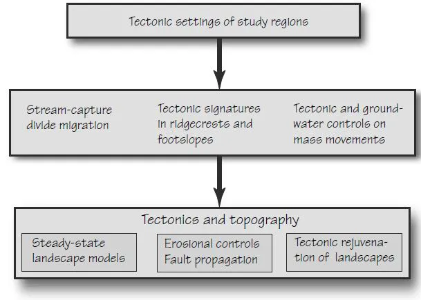
The landforms of tectonically active landscapes have definitive characteristics that reflect local rates of rock uplift, climate, and rock mass strength. This book is about the nature of these signatures and how the hills and streams of fluvial systems change with the passage of time. The three blocks of Figure 1.1 diagram the flow of topics presented in the three parts of the book. A discourse that focuses mainly on streams is worthy of a separate book, perhaps “Fluvial Tectonic Geomorphology”.
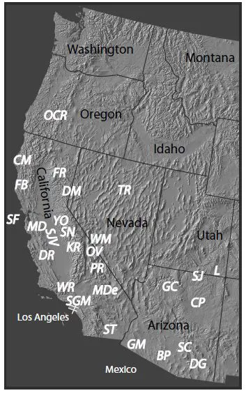
We use tectonic signatures in landforms to explore several topics in tectonics and topography. I present data and analyses from study areas in quite different tectonic, climatic, and lithologic settings. Insight gained from study sites in the southwestern United States, Greece, New Zealand, and the Himalayas should aid you in resolving similar problems in your favorite geographical settings. Study site locations of this book are shown in Figures 1.2, 1.9, and 1.13. The captions for these three figures contain links to chapter section numbers. A fluvial emphasis here excludes permafrost and glaciers, sand seas, lacustrine and tidal settings, and active volcanoes – but includes marine terraces.
I use a variety of geomorphic concepts, and presume that you know these key principles. A broad base of essential tools lets us explore diverse approaches in tectonic geomorphology. They include a sensitive erosional–depositional threshold, time lags of response to perturbations, type 1 and type 2 dynamic equilibrium, local and ultimate base levels, impediments to the continuity of fluvial systems, and the process of tectonically induced downcutting to the base level of erosion. See the Glossary for basic definitions. Chapter 2 in a companion book is devoted to defining and discussing these essential tenets; see “Tectonic Geomorphology of Mountains” (Bull, 2007). Chapter 1 of that book assesses the nuances of scrunch and stretch bedrock uplift.
Quaternary temporal terms (Table 1.1) have been assigned conventional ages. The 12-ka age assignment for the beginning of the Holocene is arbitrary and is preceded by the transition between full-glacial and interglacial climatic conditions. Unless specifically noted, radiocarbon ages are conventional (using the old 5,568 year half-life allows comparison with dates in the older literature) and have been corrected for isotope fractionation. The term “radiocarbon age” means that the correct 5,730 year half-life is used and that variations in atmospheric 14C have been accounted for, using the techniques of Stuiver et al. (1998). Calibration of radiocarbon ages (Bard et al., 1990) shows that the peak of full-glacial conditions may be 22 ka instead of the conventional radiocarbon age estimate of 18 ka. The 125- and 790-ka ages are radiometric and paleomagnetic ages that have been fine-tuned using the astronomical clock (Johnson, 1982; Edwards et al., 1987a, b). The 1,650-ka age is near the top of the Olduvai reversed polarity event (Berggren et al., 1995).
Figure 1.1 Flow chart of major topics of this book by chapter.
1.2 North America–Pacific Plate Boundary
The San Andreas transform boundary between the North America and Pacific plates in the southwestern United States is a 200–800 km wide transition zone extending from Pacific Ocean coastal fault zones far into the Basin and Range Province. Two primary components control many secondary tectonic features of the transition zone. The following synopsis emphasizes coincidences of timing of important tectonic events in the boundary between the Pacific and North American plates. The San Andreas fault is the primary plate-boundary fault zone at the present time. This right-lateral continental transform fault slices through batholithic complexes to create the Peninsular and Transverse Ranges of southern California. It then continues through the central and northern Coast Ranges, and turns west at Cape Mendocino to join the Mendocino fracture zone (Fig. 1.3).
The Sierra Nevada microplate is an equally important component. This 650 km long mountain range was created by batholithic intrusions in the Mesozoic. The mountain range is long but the microplate is immense because it also includes the adjacent Central Valley of California (Fig. 1.3). This tectonic block has minimal internal deformation but the eastern side of the Sierra Nevada was raised abruptly at about 4 ka (Jones et al., 2004; Saleeby and Foster, 2004). An impressive escarpment now rises 1,000 m in the north and 2,000 m in the south (Fig. 1.4).
Table 1.1 Assigned ages of Quaternary temporal terms, in thousands of years before present (ka).
Age
ka
Holocene
Late
0–4
Middle
4–8
Early
8–12
Pleistocene
Latest
12–22
Late
12–125
Middle
125–790
Early
790–1,650
Figure 1.2 Locations and study sites in the western United States and their book section numbers [3.5]. BP, Baboquivari Peak [3.6.1]; CM, Cape Mendocino [1.2.4, 4.2.2, 8.3]; CP Colorado Plateau [3.5]; DG, Downpour Gulch [3.4.2]; DM, Diamond and Fort Sage Mountains [8.1]; DR, Diablo Range sites including the Ciervo Hills, Dormant Hollow, Kettleman Hills, Laguna Seca Hills, Panoche Hills, Tumey Hills, and Vigorous Vale [1.2.3, 2.3.2.2, 3.2, 3.2, 3.7, 5.1, 5.4]; FB, Fort Bragg [8.3]; GC, Grand Canyon [3.5]; GM, Gila Mountains [3.6]; KR, Kings River [8.2]; MDe, Mojave Desert [1.2.1, 8.1]; FR, Feather River and Mount Lassen and the southern end of the subduction related Cascade volcanoes [8.2.2]; L, The Loop abandoned meander [3.5.1]; MD, Mount Diablo [2.3.2.2]; OCR, Oregon Coast Ranges; [3.4, 3.7]; OV Owens Valley[1.2.1, 8.1, 8.2]; PR, Panamint Range and Death Valley, [1.2.1.1, 2.2.1, 8.1.1]; SC, Santa Catalina Mountains [2.3.1]; SF, San Francisco Bay region [2.3.2.2, 4.2.1.2.2]; SGM, San Gabriel Mountains [3.6.2]; SJ, San Juan River [3.5.1]; SJV San Joaquin Valley [1.2.3, 3.4.1, 7.5.2]; SN, Sierra Nevada microplate [1.2.2, 5.3.2, 8.2]; ST, Salton Trough [1.2.1]; TR, Tobin Range [7.1.1]; WM, White Mountains [1.2.1, 7.3]; WR, Wheeler Ridge [7.2.2]; YO, Yosemite National Park [6.1]. Digital topography courtesy of Richard J. Pike, US Geological Survey.
Figure 1.3 Tectonic setting of southwestern United States. Numbered lines show the northward migration of the south edge of the Gorda plate (from Atwater and Stock, 1998) to its present position at the Mendocino triple junction. Mendocino fracture zone extends northwest, and the Cascadia subduction zone north, from the triple junction. The Sierra Nevada microplate was wider at 5 Ma because it extended west almost to the San Andreas fault, and extended east into the Basin and Range Province. Area within the solid line outlines the area of accelerated extensional faulting since 5 Ma (Jones et al., 2004, figure 1). This area and the area inside the dashed line approximate the province of the Walker Lane–Eastern California shear zone, that has accommodated >10% of the plate-boundary dextral shear since 5 Ma. Areas of sinestral shear act as transrotational domains that facilitate tectonic linking within the plate boundary (Dickinson and Wernicke, 1997).
A major tectonic event – detachment of the changed important tectonic processes elsewhere in Sierra Nevada batholithic root – (called delamination) the San Andreas transform boundary. Crustal extenresulted in a pulse of uplift of the microplate, and sion accelerated into the eastern margin of the Sierra Nevada, thus making the Basin and Range Province ever broader. See Figure 1.3. The San Andreas fault dextral shear zone split to create the seemingly diffuse Walker Lane–Eastern California shear zone in eastern California and western Nevada. Parts of the central Coast Ranges were created since the delamination event. The following summaries are made in the context of how this batholithic-root detachment affected the rates and styles in each distinct tectonic province.
Geomorphic features of hills and streams in of each study area tell us more about present and past tectonic activity. The rates and styles of tectonic activity, briefly noted in this introductory chapter, will be deciphered and discussed further when the tectonic geomorphology is presented for each study area.
1.2.1 Walker Lane–Eastern California Shear Zone
About 10 to 20% of the dextral shear between the Pacific and North American plates split off from the San Andreas fault at 3 to 5 Ma. Unlike the San Andreas fault, movements along this much younger shear zone seem dispersed. Diffuse, and appearing spatially intermittent, this is called the “Eastern California shear zone” in the south and the “Walker Lane shear zone” in the north. Two prominent dextral active faults in the south are separated by 100 km – the 310 km long Death Valley–Fish Lake and the 110 km long Owens Valley fault zones (Reheis and Dixon, 1996). Two active dextral fault zones in the north are separated by 60 km – Honey Lake and Mohawk Valley (Wills and Borchardt, 1993). Field studies and seismic analyses reveal additional widespread dextral faulting.
The importance of the San Andreas as a plate boundary fault is obvious because of its 300 km of cumulative displacement since 30 Ma (Dickinson, 1996). Magnitude Mw >7 earthquakes occurred on this fault in A.D. 1812, 1838, 1857, and 1906.
In marked contrast the Walker Lane–Eastern California shear zone initially appeared so intermittent and diffuse that it has taken a century to recognize its importance. Nevertheless, historic earthquakes attest to its tectonic significance. It too has had four Mw >7 dextral earthquakes since A.D. 1800 including the magnitude Mw 7.6 Owens Valley earthquake of 1872, the Mw 7.2 Cedar Mountain event of 1932 in western Nevada, the Mw 7.3 Landers earthquake in 1992 and Mw 7.1 Hector Mine earthquake in 1999; both recent events were in the central Mojave Desert.
Geodetic measurements indicate right-lateral shear between the Pacific and North American plates of about 10 to 14 m/ky (Bennett et al., 1999; Dixon et al., 2000; Argus and Gordon, 2001). The Sierra Nevada microplate has been rotated counterclockwise in response to deformation of adjacent tectonic provinces.
Extension of the distinctive Basin and Range Province began at 35 Ma in the north and had propagated to the south by 20 Ma (Dilles and Gans, 1995). Such normal faulting migrated westward during the late Cenozoic by encroaching into the Sierra Nevada microplate. The microplate was much wider just 5 My ago (Fig 1.3).
Uplift and eastward tilting of the lofty White Mountains as a separate block (Guth, 1997) began at 12 Ma (Stockli et al., 2003), which is the same time as encroachment near Reno created the Carson Range (Henry and Perkins, 2001). This early episode of synchronous normal faulting occurred along nearly 300 km of the Sierra Nevada–Basin and Range boundary. The Panamint Range also may have been created at this time.
Range-bounding normal faulting after ~3.5 Ma created the eastern escarpment of the Sierra Nevada (Fig. 1.4) and increased relief of the White and Inyo Mountains on the other side of Owens Valley. Neither synchronous episode of tectonic rejuvenation was related to the continued migration of the Mendocino triple junction (Unruh, 1991).
This encroachment has reduced the width of the Sierra Nev...
Table of contents
Cover
Title
Copyright
Preface
Chapter 1: Tectonic Settings f the Study Regions
Chapter 2: Drainage Basins
Chapter 3: Hillslopes
Chapter 4: Sediment Yield and Landslides
Chapter 5: A Debate About Steady State
Chapter 6: Erosion and Tectonics
Chapter 7: Fault-Propagation Landscapes
Chapter 8: Tectonic Geomorphology of a Plate Boundary
Glossary
Appendix A
References Cited
Index
Frequently asked questions
Yes, you can cancel anytime from the Subscription tab in your account settings on the Perlego website. Your subscription will stay active until the end of your current billing period. Learn how to cancel your subscription
No, books cannot be downloaded as external files, such as PDFs, for use outside of Perlego. However, you can download books within the Perlego app for offline reading on mobile or tablet. Learn how to download books offline
Perlego offers two plans: Essential and Complete
Essential is ideal for learners and professionals who enjoy exploring a wide range of subjects. Access the Essential Library with 800,000+ trusted titles and best-sellers across business, personal growth, and the humanities. Includes unlimited reading time and Standard Read Aloud voice.
Complete: Perfect for advanced learners and researchers needing full, unrestricted access. Unlock 1.5M+ books across hundreds of subjects, including academic and specialized titles. The Complete Plan also includes advanced features like Premium Read Aloud and Research Assistant.
Both plans are available with monthly, semester, or annual billing cycles.
We are an online textbook subscription service, where you can get access to an entire online library for less than the price of a single book per month. With over 1.5 million books across 990+ topics, we’ve got you covered! Learn about our mission
Look out for the read-aloud symbol on your next book to see if you can listen to it. The read-aloud tool reads text aloud for you, highlighting the text as it is being read. You can pause it, speed it up and slow it down. Learn more about Read Aloud
Yes! You can use the Perlego app on both iOS and Android devices to read anytime, anywhere — even offline. Perfect for commutes or when you’re on the go. Please note we cannot support devices running on iOS 13 and Android 7 or earlier. Learn more about using the app
Yes, you can access Tectonically Active Landscapes by William B. Bull in PDF and/or ePUB format, as well as other popular books in Physical Sciences & Geology & Earth Sciences. We have over 1.5 million books available in our catalogue for you to explore.