![]()
1
Beginnings: From Fire and Ice to Indian Homeland
Fire and ice forged the physical setting of California’s storied past. No matter how extensively humans have altered that setting with mining activities, transportation systems, aqueducts, and various other built structures, nature always has been integral to the state’s history. Before there was a human record there was pre-history, or a time of beginnings, by far the longest period in California’s timeline. During this genesis California literally rose from the Pacific, at times spewing flames and volcanic ash. Violent thrusts from below the Earth’s surface formed mountains and valleys that later would be carved by huge rivers of ice. Before these glaciers began melting, some 15,000 years ago, America’s first human inhabitants began making their way by foot and watercraft from Asia to North America. On reaching the New World, these mammoth-hunting migrants trekked southward and eastward, some settling in what would become California. Their seagoing Asian counterparts navigated North America’s coastline southward to the Channel Islands and mainland. These trekking and sailing Paleolithic, or Old Stone Age, peoples were the first human occupants of this remarkable land. Some scholars speculate that Polynesian and Chinese Pacific voyagers visited Indian California centuries before Europeans arrived in the province.
Timeline
| 30 million years ago | California’s land mass was formed by Pacific geological processes, especially through plate tectonic subductions and lateral movements |
| 13,000 years ago | Following the “Kelp Highway,” Asian Pacific voyagers arrive in the Channel Islands, perhaps becoming the first Californians, according to archeologist Jon M. Erlandson and others |
| 10,000 to 15,000 years ago | As climate warming set in and Beringia melted into the Bering Strait, the descendants of Paleo-Indian migratory hunters continue on their way eastward and southward throughout the New World in pursuit of game |
| 11,000 years ago | The skeletal remains of the so-called Arlington Woman are found at a site on Santa Rosa Island along California’s coast |
| 4,600 years ago | A bristlecone pine (Pinus longaeva), located in California’s White Mountains and dating back more than four millennia, is thought to be the oldest living thing on Earth |
| 2,000 years ago | Some of today’s California redwood trees, the world’s largest living things, date to the time of Jesus of Nazareth and the Roman Empire |
| 1000 CE | Chumash Indians build a seafaring culture in and around today’s Santa Barbara and on a few of the Channel Islands |
| 400–800 | Early Polynesians may have reached California in watercraft, according to a small group of anthropologists and linguists |
| 1500s | Specialists estimate that 15,000 Chumash lived in California at the time of European contact |
| Late 1700s | Between 300,000 and 1,000,000 indigenous people inhabited California most of them living in villages of 100 to 500 dwellers |
Landforms
Not only was California born of the Pacific, also it is situated on the Ring of Fire, an intercontinental perimeter of volcanoes and earthquake faults that line the Pacific Rim in a sweeping arc from Japan to Chile. Like many other areas along the Ring of Fire, the state’s varied landmass was assembled over time from geologic fragments of rocks and sediments, called “terranes,” lying on the crust or floor of the Pacific long after the Earth was formed some 4.6 billion years ago. Before these fragments began uplifting from the ocean, North America’s western shoreline extended to about where the Rocky Mountains are situated today. West of that ancient coastline loomed the vast, heaving Pacific.
According to widely accepted plate tectonics theory, formulated by geologists in the mid-1960s, California’s landmass has evolved over hundreds of millions of years. The process has been global and ongoing. Eons ago 20 huge subterranean masses of material, called plates, comprised the Earth’s crust and upper mantle. These plates meandered due to heat and pressure from deep within the planet, creating continents. The largest of these subterranean masses, the Pacific Plate, lies beneath roughly two-thirds of the ocean by that name. The eastward-moving Pacific Plate collided with the western edge of the North American Plate in a zone somewhat west of the Rockies. At the point of collision the Pacific Plate subducted, that is, pushed beneath the North American Plate, thereby generating enormous heat. The heat, in turn, melted subterranean basalt rock that combined with deeply buried sediments to produce ores – including gold that in the mid-1800s sparked a worldwide rush to California – while pushing up the Earth’s crust and forming granite outcroppings. In this way western mountains and their basins came into existence. The initial collision was followed by subsequent ones, called “dockings” or “accretions,” that assembled California’s topography, which included offshore volcanic islands. “Wherever you stand in this state,” says geologist Keith Heyer Meldahl, “if your feet are on bedrock, the odds are that you’re standing on an immigrant [piece of ground], reeled in by subduction from the far reaches of the Pacific in the process of assembling California.” About 30 million years ago, when the area for the most part assumed its present geographical configuration, these west-to-east collisions stopped and a lateral south-to-north movement of the Pacific Plate began that continues to this day.
This lateral movement has had major consequences for the region, especially in terms of earthquakes. The Pacific Plate has been moving northwestward at about 2 inches a year. Consequently, part of Baja California was carried over millions of years to the coastline and interior reaches of southern California and up to San Francisco. This movement has been characterized by gnashing and grinding along the Pacific–North American plates’ subduction zone. Stresses from the lateral movements of the two plates force an unlocking of surface-area terrain on both sides of the fissure known as the San Andreas Fault. The forced unlocking of these blocks results in powerful earthquakes along this fault system that extends from Point Reyes Peninsula just above San Francisco southeastward for 350 miles to the mountains of southern California. Earthquakes along that fault line have devastated cities, leaving many dead and striking fear into survivors. Such was the case in 1906 when much of San Francisco was flattened and burned (due to ruptured gas lines and water mains in the city) by a severe earthquake along the San Andreas Fault. Since 1769, when the Spanish began colonizing the province, there have been 117 measured or recorded earthquakes along this fault. Geology and geography augur more to come on this and other faults in the state.
Volcanoes, plate tectonics, earthquakes, winds, and waves have formed California’s coastline, offshore islands, mountains, and basins or valleys. That coastline, with its many picturesque coves and tree-crested cliffs, is one of the most photographed and tourist-visited in the world, extending 1,264 miles in length. Monster waves, or tsunamis, generated by distant earthquakes, have on occasion reportedly reached 195 feet in height before bombarding northern California’s shores. Such a wave struck just north of Humboldt Bay in 1913. Less noteworthy yet still powerful currents of wind and sea have been sculpting coastal California for eons.
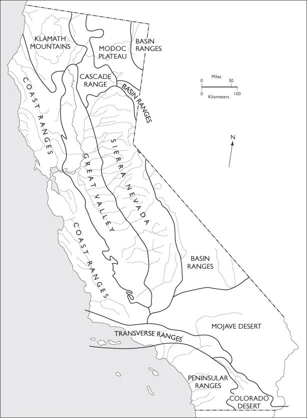
Inland from the coast, mountain ranges and plateaus of dramatically varying elevations dominate most of the state’s nearly 100 million acres of surface area. America’s third-largest state, after Alaska and Texas, California features at least half a dozen ramparts.
Two mountain chains and a high plateau occupy much of the far northern reach of the state’s boundaries. The Klamath range is located in the northwest corner of the state. Two major rivers, the Klamath and Trinity, flow through the mountains’ gorges, emptying into the Pacific. To the east the volcanic-created Cascades, which lie on a north–south axis from Washington to northern California, feature such peaks as Mt. Shasta (14,162 feet) and Mt. Lassen (10,457 feet), both of which resulted from thunderous, fiery eruptions along the Pacific Ring of Fire. Mt. Shasta’s volcanic origin goes back about 50 million years ago, while Mt. Lassen is around 200,000 years old. The Modoc Plateau, covered with rugged lava flows and site of an 1873 war between whites and Indians, is tucked in the northeastern corner of the state.
Slightly south of the Cascades, California’s highest range – the Sierra Nevada – begins its more than 400-mile span along part of the state’s eastern boundary. This relatively young rampart, the world’s longest and some 50 million years old (according to a team of Stanford scientists), is still rising, unlike the Appalachians in the eastern United States. The twin jewels of the Sierra, some say, are the glacial-carved Yosemite and Hetch-Hetchy valleys. The former is world-renowned for its granite cliffs and majestic waterfalls; the latter was transformed into a reservoir for San Francisco in the early twentieth century. A major obstacle to early overland migrants and the major construction challenge to builders of the nation’s first transcontinental railroad, the Sierra boasts the highest peak in the contiguous 48 states – Mt. Whitney (14,495 feet). Fifty other Sierra peaks measure above 13,000 feet. The eastern slopes of the Sierra Nevada, which rise abruptly out of a largely treeless basin, are especially steep as those who have hiked in that region will attest.
Beyond impressive recreational opportunities and perhaps unparalleled aesthetic endowments, the Sierra Nevada range has been a storehouse of riches in pelts, ores, timber, and water. For, example, Chinese miners in the 1850s referred to the Sierra as Gam Saan, Gold Mountain. Other valuable ores, like tungsten (used in weapon-making), were mined in the twentieth century. Rivers flowing from the Sierra, like the Feather and Tuolumne, have furnished hydroelectric power and water to farmers and thirsty Californians. Sapphire-blue Lake Tahoe, the state’s largest body of fresh water, is but one of the many lakes carved by Sierra glaciers.
The Great Basin – comprising parts of Utah, Arizona, and California – lies just east of the Sierra. Its historical importance has much to do with the early twentieth-century diversion of the Owens River into an aqueduct built to provide the inhabitants of Los Angeles with water. The resulting conflict between Owens Valley farmers and the City of Los Angeles became a major event in California’s more recent past. East of Owens Valley the White Mountains extend across the state border into Nevada.
Close to and paralleling the Pacific seaboard, the Coastal Ranges run much of the length of the state from Cape Mendocino down to Point Conception. The ranges were formed by the same subduction process, described above, which produced the state’s larger landmass. Younger than the Sierra Nevada, the Coastal Ranges – with some exceptions – generally ascend to between 3,000 and 4,000 feet. In addition to shale and sandstone, a good deal of serpentine, the state rock, can be found in these mountains.
Situated between the Coastal Ranges and the Sierra, the 450-mile-long and 50-mile-wide Central Valley was once immersed in sea water. The retreating ocean left in its wake what would evolve into one of the most fertile and productive farmlands in America, watered by the southward-flowing Sacramento River and the northward-flowing San Joaquin River. Together these two rivers formed a delta region in the state’s interior that remains linked to the Pacific by San Francisco Bay’s tributaries. The Bay’s narrow entrance and 400 square miles of inlets, which render Stockton and Sacramento Pacific ports, make it one of the world’s finest natural harbors.
Two more ramparts complete the mountainous profile of California. The southern end of the Great Valley gives way to the Transverse Ranges, so called because they extend for about 250 miles along an east–west axis that stretches to the offshore Santa Barbara Channel Islands. Still farther south, the Peninsular Ranges form the northernmost extremity of mountains that run the length of Baja California.
The state’s final landform comprises the adjoining Mojave and Colorado deserts, occupying California’s southeast corner. Death Valley, located in the Mojave, has the distinction of being the lowest point (282 feet below sea level) in North America. South of Death Valley, the Colorado Desert stretches to the Mexican border.
Climates
Just as California’s land mass was Pacific-born much the same is true for its climates, which are as diverse as its topographic features. Rainfall, temperature, and sunlight vary so significantly throughout the state that meteorologists speak of its micro-climates. Even within distinct geographical areas climates, especially temperatures, can fluctuate dramatically on a seasonal basis. Since the beginning of European settlement in California, climate has become increasingly important in shaping the state’s economy.
As elsewhere, California’s climates are influenced by many variables including wind patterns, ocean currents, and high-elevation mountains. The dominant weather pattern is for the westerly winds (precipitation-bearing onshore winds from the Pacific) to blow during the winter months, depositing rain – and in some places snow – from the northern to the southern end of the state. These somewhat warm winds have a swirling effect that draws colder ocean water to the surface, creating coastal fogs from the resulting air–moisture mix and condensation. Inland from the fog-shrouded coast, high-elevation mountains intercept the moisture carried by the prevailing westerlies while blocking their flow eastward. Hence the much drier and often arid weather east of the Coastal, Sierra Nevada, San Gabriel, and San Bernardino mountains.
The flow pattern of the westerlies is largely inoperative in the spring, summer, and early fall months when hot, dry winds blow from interior deserts toward the ocean. In southern California, for example, the Santa Ana winds often produce drought conditions, which, in turn, have resulted in hazardous fires. The Witch (Creek) fire in October 2007, for example, destroyed more than a thousand homes north and east of San Diego. Drought and Santa Ana wind gusts of up to 100 miles per hour forced the closure of many schools; the entire town of Julian was evacuated. Such wildfires have become more frequent and severe in recent decades.
Drought and wildfires occur throughout California despite the plentiful rainfall in the northern as compared to the southern part of the state. Temperatures rarely rise above 70 degrees Fahrenheit (F) in the northwestern corner of the state, where average annual rainfall exceeds 100 inches. The Mojave Desert in the southeastern part of the state represents the other end of the climate continuum. There temperatures can swing from below freezing in winter to summer highs above 120 degrees F. The average annual precipitation is 1.5 inches. In Furnace Creek, Death Valley, located in the Mojave, the American heat record was set on July 10, 1913, when the thermometer reached a hellish 136.4 degrees F! In what is billed as “the world’s toughest foot race,” athletes compete annually in the Badwater ultra-marathon, a grueling 135-mile run from Badwater, Death Valley to Mt. Whitney – from the lowest to the highest elevations in th...