This introductory textbook has been completely revised and updated, and is accompanied by a website which provides additional illustrations, global examples, case-studies and more detailed and advanced information on topics referenced in the book, together with explanations of terminology, annotated references and research material.
- English
- ePUB (mobile friendly)
- Available on iOS & Android
eBook - ePub
About this book
Coastal Geomorphology, Second Edition is a comprehensive and systematic introduction to this subject and demonstrates the dynamic nature of coastal landforms, providing a background for analytical planning and management strategies in coastal areas that are subject to continuing changes.
Trusted by 375,005 students
Access to over 1.5 million titles for a fair monthly price.
Study more efficiently using our study tools.
Information
1
Introduction
1.1 Coastal geomorphology
More than half the world’s population lives in coastal regions, and many people visit the coast frequently. Most come for seaside recreation, but some also wonder about the origins of coastal scenery. A walk along the shore or a coastal footpath prompts questions about how such features as cliffs, rocky outcrops, beaches and dunes formed, and how and why they are changing. A coastal journey is likely to encounter estuaries, lagoons and river deltas that have evolved over longer periods, and it soon becomes clear that sea level has not always been where it is now.
Coastal geomorphology deals with the shaping of coastal features (landforms), the processes at work on them and the changes taking place. Coastal geology is concerned with the rock formations and structures seen in cliff and shore outcrops, and the sediments that have been deposited in coastal regions. It provides the background for coastal geomorphology.
Apart from incidental comments by classical Greek and Roman observers and by Leonardo da Vinci, the first systematic attempts to explain coastal landforms were by 19th century scientists such as Charles Lyell and Charles Darwin, and the pioneer American geomorphologist William Morris Davis. While a great deal of work was done in the 20th century on various parts of the world’s coastline, particularly in Europe and North America, it is only in the past few decades that coastal research has become widespread, and there is still plenty of opportunity for original contributions.
Coastal geomorphology has several themes, each of which will be discussed in this book.
(a) The shaping of landforms in relation to geology, processes, variations in climate and the relative levels of land and sea.
(b) Coastline changes measured over specified periods, with analyses of their causes.
(c) Nearshore processes and responses, particularly on beaches.
(d) Evidence of geological history, notably changes in land and sea level and climatic variations.
(e) The sources and patterns of movement of coastal sediment.
(f) The array of weathering processes in the coastal zone.
1.2 Terminology
The coast consists of a number of zones (Figure 1.1). The shore is the zone between the water’s edge at low tide and the upper limit of effective wave action, usually extending to the cliff base. It includes the foreshore, exposed at low tide and submerged at high tide, and the backshore, extending landward from the normal high tide limit, but inundated by exceptionally high tides or by large waves during storms. The shoreline is strictly the water’s edge, migrating to and fro as the tide rises and falls.
Figure 1.1 Coastal terminology
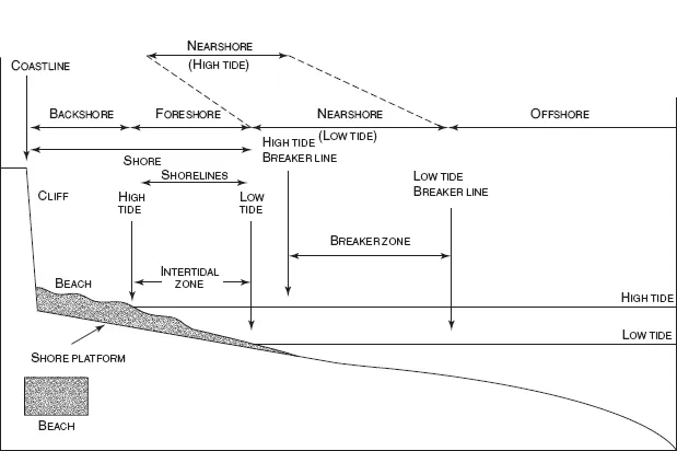
The nearshore zone, comprising the surf zone (with breaking waves) and the swash zone (covered as each wave runs up the foreshore), also migrates to and fro as the tides rise and fall. The breaker zone (where waves are disrupted) is bordered seaward by the offshore zone, extending to an arbitrary limit in deep water. The terms offshore, onshore and longshore are also used to describe directions of flow of wind, water or sediment.
A beach is an accumulation of loose sediment, such as sand, gravel or boulders, sometimes confined to the backshore but often extending across the foreshore as well. Some beaches extend down to, and below, low tide level. Shingle is beach gravel, especially where the stones are well rounded.
The coast is a zone of varying width, including the shore and the nearshore zone, out at least to the line where waves break, and extending inland to the limit of penetration of marine influences: the crest of a cliff, the head of a tidal estuary, or the rising ground behind coastal lowlands, or dunes, lagoons and swamps. The coast is thus the zone where land, sea and air (the lithosphere, hydrosphere and atmosphere) meet and interact. It is subject to an array of processes, including tectonic movements (upward, downward or laterally) of the land margin, changes in sea level, the effects of tides, waves and currents in the sea and variations in temperature, pressure and wind action in the atmosphere. Some coasts have been shaped primarily by erosion, others by deposition. Erosion is the removal of rock material, and the term denudation is used where surface rock is removed to expose underlying rock formations and structures to further erosion.
The term coastline indicates the land margin at normal high spring tide (behind the backshore zone), and may be the base of a cliff or the seaward margin of dunes or dry land. In American literature the term shoreline (or seaboard) is often used as a synonym for coastline, while the coast is elaborated to the coastal zone. The preference here is to maintain a distinction between coastline and shoreline (Panel 1.1), acknowledging that the shoreline moves to and fro as tides rise and fall, so that one can define a low-tide shoreline, a mid-tide shoreline, and a high-tide shoreline.
Panel 1.1 Coastline or shoreline?
| The coastline is defined as the edge of the land at the limit of normal high spring tides; the subaerial land margin, often marked by the seaward boundary of terrestrial vegetation. On cliffed coasts it is taken as the cliff foot at high spring tide level. |
| The shoreline is the water’s edge, moving to and fro as the tides rise and fall, so that there is a low-tide shoreline, a mid-tide shoreline and a high-tide shoreline. Shorelines thus move to and fro as the tide rises and falls, whereas coastlines are submerged only in exceptional circumstances (e.g. during storm surges). |
| If coastline and shoreline are regarded as synonyms this distinction is lost. There is a difficulty where the tide range is large, as in NW Australia, where tides exceed 10 m and the distance between the coastline (high spring tide shoreline) and the low spring tide shoreline is up to 8 km. However, the term shoreline is often used for the coastlines of lakes, estuaries and lagoons, where the tide range is generally small and the intertidal zone narrow or non-existent. |
| Many American authors have preferred the term shoreline to coastline, but there are notable exceptions: Shepard and Wanless (1971) entitled their book Our Changing Coastlines, and the leading American journal is called the Journal of Coastal Research. In the United States the term shoreline is defined legally as mean high water (MHW), as shown on nautical charts produced by the National Oceanic and Atmospheric Administration (NOAA). Shorelines at other levels are simply called lines, e.g. the mean lower low water line, which is a private property seaward boundary in some eastern states (Parker, 2001). It should be noted that the American shoreline, thus defined, is not the margin of normally dry land. |
| Details of work cited (Shepard and Wanless, 1971; Parker, 2001) are given in the References section (pp. 387–404). |
1.3 Ancient coastlines
Coastlines have existed since oceans first formed on the surface of a cooling Earth, about 4 000 million years ago, but it is difficult to find early coastlines because most of the evidence has been removed by erosion or concealed by deposition. Table 1.1 shows the geological column (the sequence of geological periods). Deposits indicating coastlines that existed in Mesozoic and Tertiary times can be found in the stratigraphy of southern Britain. An example is seen on the Haldon Hills, east of Dartmoor in SW England, where there are pebbly sands with corals and mollusc shells that represent a beach deposited in the Cretaceous, about 110 million years ago. Other fragments of ancient coastlines have been preserved far inland. In the Czech Republic there is a quarry on Kank Hill, near Kutna Hora, about 70 km east of Prague, where it is possible to stand on the Upper Cretaceous shore. A beach resting on an irregular wave-worn surface of Pre-Cambrian rock marks the limits of a Cretaceous sea that reached here about 95 million years ago (Ager, 1980). There have been many such transgressions of the sea over the land during geological time, probably related to changes in the size and shape of ocean basins, particularly during the splitting of the ancient supercontinent of Pangaea into several drifting continents, a process that began early in the Mesozoic era.
Table 1.1 The geological column: the sequence of rock formations arranged by age (my – million years).
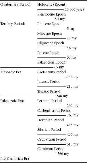
In North America the Carboniferous Period is divided into upper (Pennsylvanian) and lower (Mississippian) Periods.
Geologists recognise Formations within each Period, based on rock type (lithology), e.g. the Old Red Sandstone Formation in the Devonian and the Chalk Formation in the Cretaceous, and when these are shown on maps and in sections they are useful for geomorphology. Alternatively, they divide each period into a number of stages, based on their fossil content, but these may not correspond to lithological units.
Evidence of former coastlines becomes clearer in the most recent of the geological periods, the Quaternary, which comprises the Pleistocene (which began about 2.3 million years ago) and the succeeding Holocene (the last 10 000 years). The Quaternary period was one of major global climate and sea level fluctuations, and Quaternary coastlines can be found above and below present sea level (Chapter 3). There are Late Pleistocene beaches and shore platforms standing above present sea level on many coasts, notably in SW England and around Scotland, while submerged Pleistocene coastlines (cliffs, shore platforms and beaches) have been detected on the sea floor, notably off California and Japan. Coastal plains built forward by deposition, as in the SE United States, may include stranded remnants of coastlines of Pleistocene and Holocene age, containing evidence of past conditions that has generally been lost on receding cliffed coasts.
During cold climate phases of the Quaternary, when glaciers and ice sheets became extensive, global sea level was much lower than it is now, and when the climate of the Ice Age gave place to milder conditions there was a major world-wide sea level rise. Existing coastal landforms have been largely shaped within the past 6000 years, when the sea has stood at or close to its present level, with global climate much as it is now. Some coasts have older (relict) features, inherited from earlier environments when the sea stood higher or lower, or when the climate was warmer or colder, wetter or drier, or stormier or calmer than it is now.
1.4 Coastline morphology
Maps and charts show that few of the world’s coastlines are straight: even those of simple outline are typically gently curved. An example of an almost straight coastline is the north coast of Madura in Indonesia, which may be related to a major fault line. The almost straight 800 km east coast of Madagascar could also be fault guided, but it includes depositional sandy barriers shaped by Indian Ocean swell, and has not been produced directly by faulting. Probably the best example of a fault coast is seen in California north of San Francisco, where the coastline runs along the San Andreas Fault NW to the Bolinas Lagoon, and then follows the fault along the inner (eastern) shore of the Point Reyes peninsula bordering Tomales Bay.
There are often simple relationships between coastal outlines and the geology and topography of coastal areas. Headlands and promontories generally occur where there are outcrops of resistant rock at, above or below sea level, or where higher ground comes to the coast, as on interfluves between incised valleys. Bays have been excavated where softer rock outcrops are bordered by more resistant formations, particularly where lowlands have formed. Where there have been relatively recent tectonic movements (upward or downward, tilting or folding) of the land it is likely that uplifted sectors protrude seaward and that subsided areas have become bays.
There are distinctive cliff and shore features related to certain geological formations, such as chalk or granite, where they outcrop on the coast. However, there is not always a good correlation between coastal landforms and the outcrops of rock formations shown on geological maps, particularly when geological formations have been defined by mineralogy or palaeontology, rather than by rock type (lithology). Thus the cliffs and rocky shores on the coast of Aberdeenshire bear little relationship to several mapped divisions of the Dalradian schist, classified on the basis of their mineralogy (Ritchie, 2006). Some coasts of similar geology, latitude and aspect are compared in Panel 1.2.
Panel 1.2 Comparisons of coasts of similar geologies, latitudes and aspects
| It may be useful to compare features on similar geological formations in similar latitudes and with similar aspects: for example coastal landforms on glacial drift deposits in the Danish archipelago with those in New England and around Puget Sound. The features of the Normandy coast (such as the landslides at Les Vaches Noires and Longuessur-mer) are similar to those of the south coast of England, with contrasts related to the higher wave energy on the northern side of the English Channel. Davies (1980) suggested that features on coasts of varying aspect should be compared, for example the east and west or north and south coasts of islands such as Tasmania, Ireland or Sri Lanka. Contrasts related to aspect can be studied on islands, such as the coastal blowouts and parabolic dunes on the east and west coasts of King Island in Bass Strait (Jennings, 1957). Interpretation of the major dune formations of Fraser Island and Cooloola in SE Queensland is aided by comparisons with similar dune systems in equivalent latitudes on the coasts of southern Brazil and Mozambique. |
| On a smaller scale, there are contrasts related to local variations in exposure: on the coast of Tahiti beaches occur only inshore of gaps in the bordering coral reefs. On the west coast of the Galloway Peninsula, in Scotland, an emerged shore platform is backed by bluffs that became bolder as exposure through the ‘window’ to the Atlantic (between Islay and Ulster) increases at Bellochantuy Bay. |
| Certain rock sequences and structures produce the same kind of landform association. Similar landforms accompany particular rock sequences, as on the south coast of England where landslides occur as the Chalk gives place laterally to Upper Greensand and Gault Clay, as at Beer in Devon, White Nothe in Dorset, Freshwater Bay and Culver Cliff on the Isle of Wight, Holywell in Sussex and Folkestone in Kent. Similar features are seen at Bempton on the east coast of England, and near Boulogne and at Sainte Adresse in northern France. |
The shaping of many coastlines has been influenced by upward or downward movements of sea level (Chapter 3). Embayed coastlines with valley-mouth inlets, as on the Atlantic coasts of the United States and western Britain, are the outcome of relatively recent marine submergence (Chapter 11). Where sea level has fallen there are often emerged coastal plains and smooth coastlines where the sea floor was relatively featureless near the coast. There are exceptions where the sea floor had an irregular topography that has emerged, as in the archipelago of SW Finland.
Many coasts formed by deposition of sediments have simple, often gently curved beach-fringed outlines (e.g. much of the Gulf Coast of the United States), as have some cliffed coasts cut in fairly soft rock formations (e.g. Lyme Bay in Dorset, Figure 6.24). There are exceptions where deposition at a river mouth has formed protruding deltas. Other coasts with geological diversity are more intricate, with headlands and embayments (e.g. South China), branching inlets and ramifying peninsulas (e.g. Sulawesi in Indonesia and the Kimberley coast in northern Australia) or numerous islands (e.g. the Dalmatian coast).
Rounded bays have formed where the sea has penetrated into volcanic craters or calderas, as in the South Shetland Islands, a chain of volcanic islands parallel to the west coast of the Antarctic Peninsula. Here Deception Island is a partly collapsed volcanic cone with a rim rising to 580 m, overlooking a deep caldera penetrated by the sea to form a circular embayment. Similar rounded bays were formed by explosive eruptions at Santorini in the Aegean Sea and Krakatau, between Java and Sumatra, but these now contain younger volcanoes. Theoretically a rounded coastal embayment could be formed by marine submergence of a breached meteorite crater, but no example has been demonstrated. There are bays in breached and drowned sinkholes on the limestones of the NW coast of Gozo in Malta. Where a resistant geological formation running along the coast is backed landward by a weaker outcrop, penetration of the outer rampart by marine erosion may be followed by the excavation of a rounded embayment, as at Lulworth Cove on the south coast of England (Figure 4.28).
Smoothly curved coastlines have formed where incoming refracted waves have shaped the outlines of depositional coasts, as on the Ninety Mile Beach and in Discovery Bay, SE Australia. They are well developed on coasts exposed to ocean swell, but can also form on the shores of large bays and coastal lagoons (Section 6.9). On some coasts the smooth curvature extends across cliffed sectors in soft rock formations as well as along the intervening beaches, as in Hawke Bay on the east coast of North Island, New Zealand, and Te Waewae Bay in South Island, New Zealand. These are both shaped by refracted southerly ocean swell originating from storm centres in the Southern Ocean. On the south coast of England the Seven Sisters in Sussex are cliffs that truncate several valleys but are smooth in outline, with no inlets (Figure 1.2). The chalk cliffs are bordered b...
Table of contents
- Cover
- Title Page
- Copyright page
- Preface to the second edition
- Acknowledgements
- List of Figures
- List of Tables and Panels
- 1: Itroduction
- 2: Coastal processes
- 3: Land and sea level changes
- 4: Cliffs
- 5: Shore platforms
- 6: Beaches
- 7: Beach erosion
- 8: Spits, barriers and bars
- 9: Coastal dunes
- 10: Intertidal wetlands
- 11: Estuaries and lagoons
- 12: Deltas
- 13: Coral and algal reefs
- 14: Future coasts
- Reference
- Index
Frequently asked questions
Yes, you can cancel anytime from the Subscription tab in your account settings on the Perlego website. Your subscription will stay active until the end of your current billing period. Learn how to cancel your subscription
No, books cannot be downloaded as external files, such as PDFs, for use outside of Perlego. However, you can download books within the Perlego app for offline reading on mobile or tablet. Learn how to download books offline
We are an online textbook subscription service, where you can get access to an entire online library for less than the price of a single book per month. With over 1.5 million books across 990+ topics, we’ve got you covered! Learn about our mission
Look out for the read-aloud symbol on your next book to see if you can listen to it. The read-aloud tool reads text aloud for you, highlighting the text as it is being read. You can pause it, speed it up and slow it down. Learn more about Read Aloud
Yes! You can use the Perlego app on both iOS and Android devices to read anytime, anywhere — even offline. Perfect for commutes or when you’re on the go.
Please note we cannot support devices running on iOS 13 and Android 7 or earlier. Learn more about using the app
Please note we cannot support devices running on iOS 13 and Android 7 or earlier. Learn more about using the app
Yes, you can access Coastal Geomorphology by Eric C. F. Bird in PDF and/or ePUB format, as well as other popular books in Physical Sciences & Geology & Earth Sciences. We have over 1.5 million books available in our catalogue for you to explore.