![]()
1
Introduction
1.1 What are ‘applied’ and ‘environmental’ geophysics?
In the broadest sense, the science of geophysics is the application of physics to investigations of the Earth, Moon and planets. The subject is thus related to astronomy. Normally, however, the definition of ‘geophysics’ is used in a more restricted way, being applied solely to the Earth. Even then, the term includes such subjects as meteorology and ionospheric physics, and other aspects of atmospheric sciences.
To avoid confusion, the use of physics to study the interior of the Earth, from land surface to the inner core, is known as solid earth geophysics. This can be subdivided further into global geophysics, or alternatively pure geophysics, which is the study of the whole or substantial parts of the planet, and applied geophysics, which is concerned with investigating the Earth's crust and near-surface to achieve a practical and, more often than not, an economic aim.
‘Applied geophysics’ covers everything from experiments to determine the thickness of the crust (which is important in hydrocarbon exploration) to studies of shallow structures for engineering site investigations, exploring for groundwater and for minerals and other economic resources, to trying to locate narrow mine shafts or other forms of buried cavities, or the mapping of archaeological remains, or locating buried pipes and cables – but where in general the total depth of investigation is usually less than 100 m. The same scientific principles and technical challenges apply as much to shallow geophysical investigations as to pure geophysics. Sheriff (2002: p. 161) has defined ‘applied geophysics’ thus:
Making and interpreting measurements of physical properties of the Earth to determine sub-surface conditions, usually with an economic objective, e.g. discovery of fuel or mineral depositions.
‘Engineering geophysics’ can be described as being:
The application of geophysical methods to the investigation of sub-surface materials and structures that are likely to have (significant) engineering implications.
As the range of applications of geophysical methods has increased, particularly with respect to derelict and contaminated land investigations, the subdiscipline of ‘environmental geophysics’ has developed (Greenhouse, 1991; Steeples, 1991). This can be defined as being:
The application of geophysical methods to the investigation of near-surface bio-physico-chemical phenomena that are likely to have (significant) implications for the management of the local environment.
The principal distinction between engineering and environmental geophysics is more commonly that the former is concerned with structures and types of materials, whereas the latter can also include, for example, mapping variations in pore-fluid conductivities to indicate pollution plumes within groundwater. Chemical effects can be equally as important as physical phenomena. Since the mid-1980s in the UK, geophysical methods have been used increasingly to investigate derelict and contaminated land, with a specific objective of locating polluted areas prior to direct observations using trial pits and boreholes (e.g. Reynolds and Taylor, 1992). Geophysics is also being used much more extensively over landfills and other waste repositories (e.g. Reynolds and McCann, 1992). One of the advantages of using geophysical methods is that they are largely environmentally benign – there is no disturbance of subsurface materials. An obvious example is the location of a corroded steel drum containing toxic chemicals. To probe for it poses the real risk of puncturing it and creating a much more significant pollution incident. By using modern geomagnetic surveying methods, the drum's position can be isolated and a careful excavation instigated to remove the offending object without damage. Such an approach is cost-effective and environmentally safer.
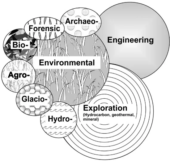
There are obviously situations where a specific site investigation contains aspects of engineering as well as environmental geophysics, and there may well be considerable overlap. Indeed, if each subdiscipline of applied geophysics is considered, they may be represented as shown in Figure 1.1, as overlapping. Also included are six other subdisciplines whose names are largely self-explanatory: namely, agro-geophysics (the use of geophysics for agriculture and soil science), archaeo-geophysics (geophysics in archaeology), bio-geophysics (geophysical manifestation of microbial activity within geological materials), forensic geophysics (the application of geophysical methods to investigations that might come before a court of law), glacio-geophysics (geophysics in glaciology) and hydro-geophysics (geophysics in groundwater investigations; see Pellerin et al. (2009) and accompanying papers). Glacio-geophysics is particularly well established within the polar scientific communities and has been since the 1950s. The application of ground-based geophysical techniques for glaciological studies (and particularly on temperate glaciers) has come of age especially since the early 1990s (see for example the thematic set of papers on the geophysics of glacial and frozen materials, Kulessa and Woodward (2007)). Forensic geophysics is now recognised as a subdiscipline of forensic geoscience (‘geoforensics’; cf. Ruffell and McKinley, 2008) and is used regularly in police investigations in searches for mortal remains, buried bullion, and so on: see Pye and Croft (2003) and Ruffell (2006) for a basic introduction and signposting to other literature. The subdiscipline of bio-geophysics has emerged over the last decade or so (e.g. Williams et al. 2005; Slater and Atekwana, 2009) and examines the geophysical signatures of microbial cells in the Earth, the interaction of micro-organisms and subsurface geological materials, and alteration of the physical and chemical properties of geological materials as a result of microbial activity. The microbial activity may be natural, as in microbial bio-mineralisation, or artificial as in the insertion of bacteria into the ground to remediate diesel spills, for example. Perhaps the newest branch is agro-geophysics (Allred et al., 2008; Lück and Müller, 2009), which has emerged over the last decade. Recent examples of these applications of geophysics include water retention capacity of agricultural soils (Lück et al., 2009, effects of long-term fertilisation on soil properties (Werban et al., 2009), and influences of tillage on soil moisture content (Müller et al., 2009).
The general orthodox education of geophysicists to give them a strong bias towards the hydrocarbon industry has largely ignored these other areas of our science. It may be said that this restricted view has delayed the application of geophysics more widely to other disciplines. Geophysics has been taught principally in Earth Science departments of universities. There is an obvious need for it to be introduced to engineers and archaeologists much more widely than at present. Similarly, the discipline of environmental geophysics needs to be brought to the attention of policy-makers and planners, to the insurance and finance industries (Doll, 1994).
The term ‘environmental geophysics’ has been interpreted by some to mean geophysical surveys undertaken with environmental sensitivity – that is, ensuring that, for example, marine seismic surveys are undertaken sympathetically with respect to the marine environment (Bowles, 1990). With growing public awareness of the environment and the pressures upon it, the geophysical community has had to be able to demonstrate clearly its intentions to minimise environmental impact (Marsh, 1991). By virtue of scale, the greatest likely impact on the environment is from hydrocarbon and some mineral exploration, and the main institutions involved in these activities are well aware of their responsibilities. In small-scale surveys the risk of damage is much lower, but all the same, it is still important that those undertaking geophysical surveys should be mindful of their responsibilities to the environment and to others whose livelihoods depend upon it.
While the term ‘applied geophysics’ covers a wide range of applications, the importance of ‘environmental’ geophysics is particularly highlighted within this book. Although the growth of this discipline has increased dramatically since the 1990s, it has not been as universally accepted as some anticipated. The reasons for this include the reluctance of some engineers to adopt modern geophysical methods, site investigation companies make more money out of drilling and trial pitting, and the perceived high cost of using geophysics rather than appreciating the subsequent ‘whole project life’ cost-benefit. What is clear, however, is that engineering and environmental geophysics are becoming increasingly important in the management of our environment.
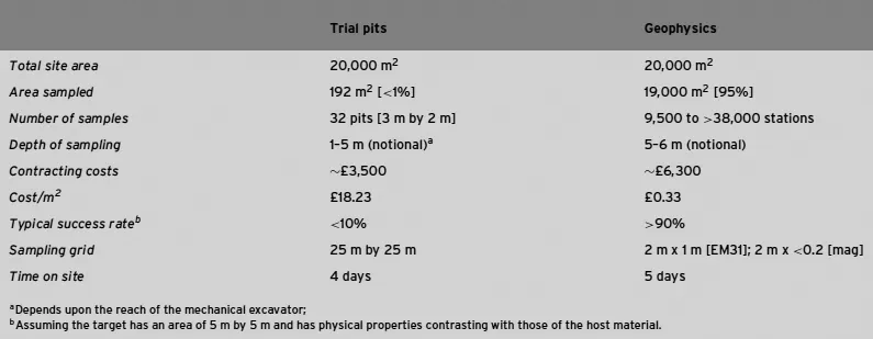
A further major advantage of the use of environmental geophysics in investigating sites is that large areas of the ground can be surveyed quickly at relatively low cost. This provides information to aid the location of trial pits and boreholes. The alternative and more usual approach is to use a statistical sampling technique (e.g. Ferguson, 1992). Commonly, trial pits are located on a 50 m by 50 m grid, and sometimes 25 m by 25 m. The disadvantage of this is that key areas of contamination can easily be missed, substantially reducing the value of such direct investigation. By targeting direct investigations by using a preliminary geophysical survey to locate anomalous areas, there is a much higher certainty that the trial pits and boreholes constructed will yield useful results. Instead of seeing the geophysical survey as a cost, it should be viewed as adding value by making the entire site investigation more cost-effective. For instance, consider the example shown in Table 1.1. On this particular site in northwest London, three successive site investigations had been undertaken over a former industrial site, involving trial pits, boreholes, and stripping 0.3 m off the ground level. For a 2 ha area, only 32 trial pits would have been used to characterise the site, representing sampling of less than 1% by area. Typically, as long as a field crew can gain access to the site on foot and the majority of obstacles have been removed, a geophysical survey can access more than 90% by area of a site. A typical geophysical survey over a brownfield (former industrial) site would consist of a ground conductivity and magnetic gradiometry survey, using dGPS for position fixing. Consequently, the line interval would commonly be 2 m and with a station interval along the line as small as 0.1 m, using a sampling rate of ten measurements a second and a reasonable walking pace for hand-carried instruments. The relative depths of penetration are as deep as a mechanical excavator can reach, typically down to 5 m below ground level; for the geophysical survey, this is a function of the method and the effective contribution of the target to form an anomaly. For a ground conductivity meter (e.g. Geonics EM31), the nominal depth of penetration is 6 m.
Table 1.1 Statistics of the use of geophysical surveys or trial pitting on a 2 ha site.
Had intrusive methods alone been used, then the probability of finding a target with dimensions of 5 m by 5 m would be <10%, whereas with geophysical methods (in this case ground conductivity and magnetic gradiometry) the success rate would be greater than 90%. Unfortunately, some clients see only the relative costs of the two methods, and geophysics loses out each time on this basis. However, if the cost-benefit is taken on the basis of the degree of success in finding objects, then the geophysical survey wins by a large margin. This is the difference between cost and cost-benefit!
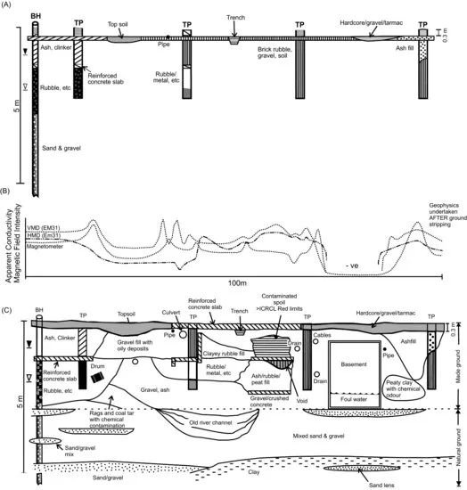
Instead of trying to have a competition between intrusive methods OR geophysics, the best practice is to use BOTH, where it is appropriate. By so doing, the geophysical survey can be used to target trial pits onto features that have been identified as anomalies by the geophysical survey. The benefit of this can be seen by reference to the two sets of ground models shown in Figure 1.2 (Reynolds, 2004b). The first model (Figure 1.2A) was produced purely as a consequence of four trial pits and one borehole. The second (Figure 1.2C) was derived following a geophysical survey (Figure 1.2B) and excavating on the locations of geophysical anomalies. It is clear that the combined approach has provided a much better knowledge of the subsurface materials.
Geophysical methods are being seen increasingly not just as a set of tools for site investigation but as a means of risk management. With the growing requirements for audit trails for liability, the risks associated with missing an important feature on a site may result in large financial penalties or legal action. For example, an environmental consultant may operate with a warranty to their...